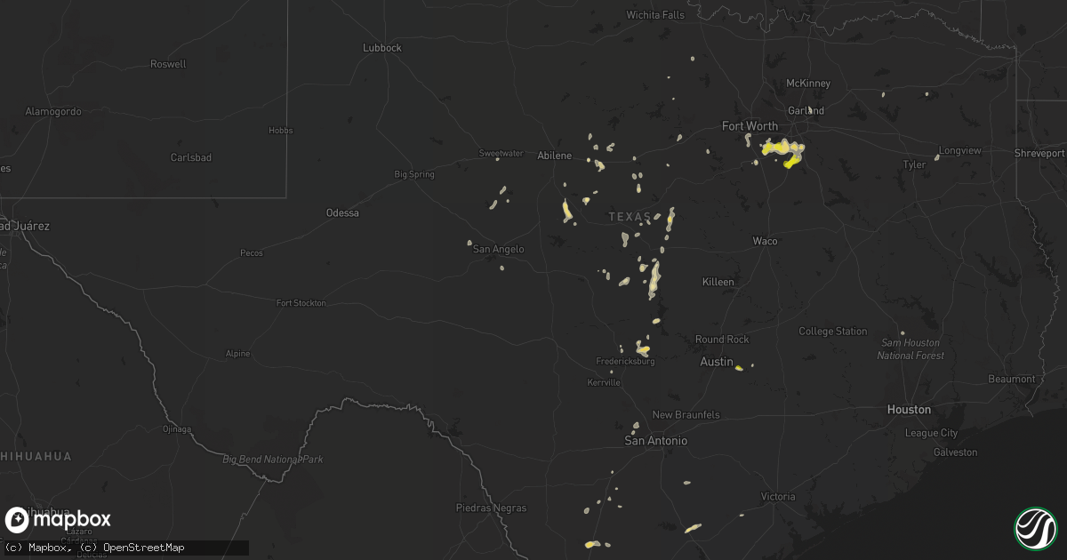
Hail Map in Texas on July 14, 2022
Get this storm
July 14 map
$229
one time, instant access
Download today. No call, no setup
Keep the $229
Bought the map and want the full workflow? Apply the entire $229 to a subscription within 7 days. None of it is wasted.
Every map, not just this one
This buys you this map. Subscription and you get every map we run, in the markets you choose from a few cities to whole states to nationwide. Plus real-time alerts the moment a storm fires.
Contact data
Name, contact info, occupancy, even credit band for addresses in the footprint. You go from where it hit to who to call.
Become the source they trust
Unlimited branding weather history reports on demand. You already have the documented answer ready for the property owner, and you are the one who showed up with it.
Property data and RoofTrace estimates
Pull up any address you have got, its value and the exact code rules for that jurisdiction, straight from One Click Code. Then RoofTrace estimates the squares, pitch, and roof value, priced the way you price.
Storm reports in Texas
Texas
| Date | Description |
|---|---|
| 07/14/20226:00 PM CDT | Asos station kmaf midland. |
| 07/14/20225:25 PM CDT | Tree down on harper road. |
| 07/14/20225:16 PM CDT | Shingles off roof and tree limbs broken. |
| 07/14/20225:09 PM CDT | A local report indicates 58 MPH wind near 4 NE VICTORIA |
| 07/14/20225:01 PM CDT | Law enforcement reported fallen tree blocking road. |
| 07/14/20224:55 PM CDT | Correction of 5:12 pm july 14 report from 3 sw fredericksburg. Measured at gillespie county airport. |
| 07/14/20224:55 PM CDT | Measured at kerv. |
| 07/14/20223:36 PM CDT | Large 30ft approx. 2.5 ft diameter chinaberry tree downed along with several pecan tree limbs. |
| 07/14/20222:58 PM CDT | A local report indicates 62 MPH wind near 5 E CHAMPION |
| 07/14/202212:25 PM CDT | Delayed report: barn blown apart... Trees down... A few large trees uprooted that took power lines down off of fm 876 a mile or so down from bigham road. Time estimated |
| 07/14/202212:20 PM CDT | Quarter size hail reported near 287 and lone star rd in northeast johnson county. |
| 07/14/202212:05 PM CDT | Trained spotter reports hail from approximately 12:05 pm to 12:10 pm. Hail up to 1.25 inches |
| 07/14/202212:00 PM CDT | 5 to 6 separate 8-10 inch tree limbs broken off separate trees along fm 876 between i-35e and brigham rd in waxahachie. |
| 07/14/202211:41 AM CDT | Delayed report: measured 60 mph wind gust near lcr 752 and 755 at 11:41 am. |
| 07/14/202211:40 AM CDT | Delayed report: 600 block of bear creek various reports of fences and trees down. Time estimated based on radar. |
| 07/14/20228:39 AM CDT | Power out and tree limbs down. Recorded gust of 41 mph. |
| 07/14/20228:30 AM CDT | Widespread downed trees... Power poles... And powerlines throughout the city of tyler. |
| 07/14/20228:22 AM CDT | *** 2 inj *** numerous trees were downed in the east lake woods subdivision along the eastern shore of lake tyler east. A large tree also fell through a mobile home nea |
| 07/14/20227:15 AM CDT | At 1215 PM CDT, a severe thunderstorm was located over Midlothian, moving southwest at 10 mph. HAZARD...60 mph wind gusts and nickel size hail. SOURCE...Radar indicated. IMPACT...Expect damage to roofs, siding, and trees. Locations impacted include... Fort Worth, Arlington, Grand Prairie, Mansfield, Cedar Hill, Burleson, Waxahachie, Cleburne, Midlothian, Crowley, Kennedale, Everman, Keene, Joshua, Alvarado, Rendon, Ovilla, Venus, Itasca and Grandview.This includes the following highways... Interstate 35W between mile markers 4 and 43. Interstate 35E between mile markers 374 and 383, and between milemarkers 400 and 402. |
| 07/14/20226:20 AM CDT | At 1119 AM CDT, a severe thunderstorm was located over Red Oak, moving south at 15 mph. HAZARD...60 mph wind gusts and penny size hail. SOURCE...Radar indicated. IMPACT...Expect damage to roofs, siding, and trees. Locations impacted include... Desoto, Lancaster, Waxahachie, Ennis, Midlothian, Glenn Heights, Red Oak, Wilmer, Ovilla, Ferris, Palmer, Oak Leaf, Maypearl, Bardwell, Garrett and Pecan Hill. |
| 07/14/20222:45 AM CDT | At 745 PM CDT, a severe thunderstorm was located near Wyldwood, or 9 miles northwest of Bastrop, moving northwest at 15 mph. HAZARD...60 mph wind gusts and quarter size hail. SOURCE...Radar indicated. IMPACT...Hail damage to vehicles is expected. Expect wind damage to roofs, siding, and trees. Locations impacted include... Austin, Bastrop, Austin Bergstrom Int Airport, Cedar Creek, Wyldwood, Camp Swift, Hornsby Bend, Webberville, Phelan, Garfield and Del Valle. |
| 07/14/20221:58 AM CDT | At 657 PM CDT, a severe thunderstorm was located over Oakville, or near Three Rivers, moving southwest at 20 mph. HAZARD...60 mph wind gusts and half dollar size hail. SOURCE...Radar indicated. IMPACT...Hail damage to vehicles is expected. Expect wind damage to roofs, siding, and trees. Locations impacted include... George West, Three Rivers, Choke Canyon, Calliham, Oakville, Simmons and Ray Point.This includes the following highways... Interstate 37 between mile markers 58 and 75. US Highway 281 between mile markers 618 and 632. US Highway 59 between mile markers 720 and 726. |
| 07/14/20221:28 AM CDT | At 628 PM CDT, a severe thunderstorm was located 12 miles south of Rocksprings, moving south at 35 mph. HAZARD...60 mph wind gusts. SOURCE...Radar indicated. IMPACT...Expect damage to roofs, siding, and trees. Locations impacted include... Brackettville, Camp Wood, Laguna, Montell, Barksdale, Alamo Village, Vance, Turkey Mountain, Fort Clark Springs and Kickapoo Cavern State Park. |
| 07/14/20221:06 AM CDT | At 604 PM CDT, outflow winds associated with a severe thunderstorm was located over Midland International Air and Space Port, or 7 miles northeast of Odessa, moving west at 40 mph. HAZARD...60 mph wind gusts. SOURCE...Radar indicated. IMPACT...Expect damage to roofs, siding, and trees. Locations impacted include... Odessa, Goldsmith, West Odessa, Notrees, Odessa Schlemeyer Field, Penwell and Pleasant Farms.This includes Interstate 20 between mile markers 93 and 121. |
| 07/14/202212:44 AM CDT | At 543 PM CDT, a severe thunderstorm was located over Midland, moving southwest at 30 mph. HAZARD...60 mph wind gusts. SOURCE...Radar indicated. IMPACT...Expect damage to roofs, siding, and trees. Locations impacted include... Midland, Odessa, Greenwood, Stanton, Midland International Air and Space Port, Courtney, Cotton Flat, Warfield, Midland Airpark and Skywest Airport.This includes Interstate 20 between mile markers 123 and 157. |
| 07/14/202212:12 AM CDT | At 512 PM CDT, severe thunderstorms were located along a line extending from near Inez to Victoria Detar Hospital North to near Ander, moving south at 20 mph. HAZARD...60 mph wind gusts and penny size hail. SOURCE...Radar indicated. IMPACT...Expect damage to roofs, siding, and trees. Locations impacted include... Victoria, Guadalupe, Fannin, Victoria Colony Creek Country Club, Schroeder, Dacosta, Wood Hi, Bloomington, Victoria Detar Hospital North, Victoria Riverside Park, Placedo, Coleto Creek Park, Victoria College, Victoria Mall, Saxet Lakes, Brentwood Subdivision, Oak Village, Inez, Victoria Regional Airport and Telferner.This includes the following highways... US Highway 183 between mile markers 632 and 634. US Highway 59 between mile markers 624 and 664. US Highway 77 between mile markers 572 and 594. US Highway 87 between mile markers 804 and 830. |
| 07/14/202212:10 AM CDT | At 510 PM CDT, a severe thunderstorm was located near Willow City, or 11 miles northeast of Fredericksburg, moving southwest at 35 mph. HAZARD...60 mph wind gusts and quarter size hail. SOURCE...Radar indicated. IMPACT...Hail damage to vehicles is expected. Expect wind damage to roofs, siding, and trees. Locations impacted include... Kerrville, Fredericksburg, Comfort, Ingram, Stonewall, Camp Verde, Tivydale, Kerrville-Schreiner Park, Rocky Hill, Rocky Creek, Hye, Blumenthal, Center Point, Albert, Grapetown, Luckenbach, Cain City, Old Tunnel State Park, Willow City and LBJ State Park. |
| 07/13/202211:46 PM CDT | At 446 PM CDT, a severe thunderstorm was located 9 miles northeast of Christoval, moving southeast at 10 mph. HAZARD...60 mph wind gusts and nickel size hail. SOURCE...Radar indicated. IMPACT...Expect damage to roofs, siding, and trees. This severe thunderstorm will remain over mainly rural areas of southeastern Tom Green County. |
| 07/13/202211:36 PM CDT | At 436 PM CDT, a severe thunderstorm was located over Gainesville, or near Kingsland, moving west at 20 mph. HAZARD...60 mph wind gusts and quarter size hail. SOURCE...Radar indicated. IMPACT...Hail damage to vehicles is expected. Expect wind damage to roofs, siding, and trees. Locations impacted include... Kingsland, Gainesville, Prairie Mountain, Oxford and Enchanted Rock State Natural Area. |
| 07/13/202211:27 PM CDT | At 427 PM CDT, a severe thunderstorm was located near Arden, moving southwest at 15 mph. HAZARD...70 mph wind gusts and quarter size hail. SOURCE...Radar indicated. IMPACT...Hail damage to vehicles is expected. Expect considerable tree damage. Wind damage is also likely to mobile homes, roofs, and outbuildings. This severe thunderstorm will remain over mainly rural areas of northwestern Tom Green and northeastern Irion Counties. |
| 07/13/202210:49 PM CDT | At 348 PM CDT, a severe thunderstorm was located near Chappel, moving southwest at 35 mph. HAZARD...60 mph wind gusts and quarter size hail. SOURCE...Radar indicated. IMPACT...Hail damage to vehicles is expected. Expect wind damage to roofs, siding, and trees. This severe thunderstorm will be near... Cherokee around 400 PM CDT. |
| 07/13/20229:58 PM CDT | At 257 PM CDT, a severe thunderstorm was located near Moran, moving south at 15 mph. HAZARD...60 mph wind gusts and penny size hail. SOURCE...Radar indicated. IMPACT...Expect damage to roofs, siding, and trees. This severe thunderstorm will be near... Putnam around 325 PM CDT.Other locations impacted by this severe thunderstorm include I-20Near The Callahan-Eastland County Line.This includes Interstate 20 between Mile Markers 312 and 323. |
| 07/13/20229:57 PM CDT | At 257 PM CDT, a severe thunderstorm was located near Bronte, moving south at 25 mph. HAZARD...60 mph wind gusts and penny size hail. SOURCE...Radar indicated. IMPACT...Expect damage to roofs, siding, and trees. This severe thunderstorm will be near... Robert Lee around 305 PM CDT. Tennyson around 330 PM CDT.Other locations impacted by this severe thunderstorm include OakCreek Reservoir and The Intersection Of Highway 208 And Ranch Road2662. |
| 07/13/20229:25 PM CDT | At 225 PM CDT, a severe thunderstorm was located 10 miles southeast of Gustine, or 10 miles west of Hamilton, moving south at 25 mph. HAZARD...60 mph wind gusts and quarter size hail. SOURCE...Radar indicated. IMPACT...Hail damage to vehicles is expected. Expect wind damage to roofs, siding, and trees. This severe thunderstorm will remain over mainly rural areas of southwestern Hamilton and southeastern Comanche Counties. |
| 07/13/20228:57 PM CDT | At 157 PM CDT, a severe thunderstorm was located 7 miles southwest of Gustine, or 11 miles southeast of Comanche, moving southwest at 25 mph. HAZARD...60 mph wind gusts and quarter size hail. SOURCE...Radar indicated. IMPACT...Hail damage to vehicles is expected. Expect wind damage to roofs, siding, and trees. Locations impacted include... Goldthwaite and Mullin. |
| 07/13/20228:41 PM CDT | At 140 PM CDT, a severe thunderstorm was located near Glen Cove, moving south at 25 mph. HAZARD...60 mph wind gusts. SOURCE...Radar indicated. IMPACT...Expect damage to roofs, siding, and trees. This severe thunderstorm will be near... Glen Cove around 150 PM CDT. Talpa around 205 PM CDT. Valera around 210 PM CDT. Voss around 215 PM CDT.Other locations impacted by this severe thunderstorm include Mozelle,Fisk and Hords Creek Reservoir. |
| 07/13/20228:35 PM CDT | Part of chapel hill high schools cafeteria roof was blown off. |
| 07/13/20228:16 PM CDT | At 116 PM CDT, a severe thunderstorm was located near Echo, or near Burkett, moving south at 10 mph. HAZARD...60 mph wind gusts. SOURCE...Radar indicated. IMPACT...Expect damage to roofs, siding, and trees. This severe thunderstorm will be near... Coleman around 200 PM CDT.Other locations impacted by this severe thunderstorm include Echo andUs-283 Near The Coleman-Callahan County Line. |
All States Impacted by Hail Map on July 14, 2022
Cities Impacted by Hail Map on July 14, 2022
- Steele, ND
- Robinson, ND
- Two Dot, MT
- Martinsdale, MT
- Reform, AL
- Millport, AL
- Lavina, MT
- Mansfield, TX
- Drake, ND
- Anamoose, ND
- Santo, TX
- Crystal River, FL
- Savannah, GA
- Port Wentworth, GA
- Bowie, TX
- Round Mountain, TX
- Willow City, TX
- Johnson City, TX
- Fredericksburg, TX
- Kissimmee, FL
- Middleboro, MA
- Vero Beach, FL
- Okeechobee, FL
- Bradenton, FL
- Oviedo, FL
- Dilley, TX
- Sheyenne, ND
- Saint Michael, ND
- San Antonio, TX
- Dublin, TX
- Gustine, TX
- Pottsville, TX
- Hamilton, TX
- Carlton, TX
- Bastrop, TX
- Bridger, MT
- Roberts, MT
- Columbus, MT
- Lodge Grass, MT
- Joliet, MT
- Fromberg, MT
- Hawthorne, FL
- Helotes, TX
- Gardner, ND
- Audubon, MN
- Lake Park, MN
- Sabin, MN
- Wolverton, MN
- Rothsay, MN
- Pelican Rapids, MN
- Barnesville, MN
- Princeton, MN
- Carver, MA
- Wareham, MA
- Plymouth, MA
- Birney, MT
- Bloomer, WI
- Cushing, MN
- Randall, MN
- Tolna, ND
- Pekin, ND
- Lafayette, AL
- Crowley, TX
- Burleson, TX
- Fort Worth, TX
- Moran, TX
- Cisco, TX
- Warwick, ND
- Oberon, ND
- Bristol, FL
- Rincon, GA
- Guyton, GA
- Bryson, TX
- Hardeeville, SC
- Brook Park, MN
- Hinckley, MN
- Hawley, MN
- Arthur, ND
- Grandin, ND
- Hillsboro, ND
- Argusville, ND
- Hunter, ND
- Harwood, ND
- Casselton, ND
- Galesburg, ND
- Blanchard, ND
- Mapleton, ND
- Goldthwaite, TX
- Park River, ND
- Comanche, TX
- Gorman, TX
- De Leon, TX
- Springfield, GA
- Walterboro, SC
- Manilla, IA
- Irwin, IA
- West, MS
- Saint Cloud, FL
- Eastland, TX
- Ranger, TX
- Comstock, WI
- Cumberland, WI
- Mullin, TX
- Lava Hot Springs, ID
- Dallas, WI
- Barron, WI
- Chetek, WI
- Cameron, WI
- Bancroft, ID
- Midlothian, TX
- Marshfield, MA
- Duxbury, MA
- Baird, TX
- Sarasota, FL
- Durant, MS
- Lexington, MS
- Early, TX
- Brownwood, TX
- Cotulla, TX
- Beatrice, NE
- Wymore, NE
- Blue Springs, NE
- Odell, NE
- Pierz, MN
- Little Falls, MN
- Fort Ripley, MN
- Vining, MN
- Parkers Prairie, MN
- Mount Pleasant, TX
- Mount Vernon, TX
- Ruffin, SC
- Winona, TX
- Kilgore, TX
- Gladewater, TX
- Mertzon, TX
- Carlsbad, TX
- Burkett, TX
- Carbon, TX
- San Saba, TX
- Foreston, MN
- Hillman, MN
- Milaca, MN
- Foley, MN
- Port Charlotte, FL
- Rotonda West, FL
- Englewood, FL
- Mount Dora, FL
- Decker, MT
- Live Oak, FL
- Bronte, TX
- Rochelle, TX
- Roundup, MT
- Cadott, WI
- Lakeville, MA
- Humarock, MA
- Berkley, MA
- Kingston, MA
- Norwell, MA
- Taunton, MA
- East Taunton, MA
- Bridgewater, MA
- Halifax, MA
- North Dighton, MA
- Hanson, MA
- Raynham, MA
- Pembroke, MA
- Dighton, MA
- Plympton, MA
- Farmingville, NY
- Centereach, NY
- Selden, NY
- Islandia, NY
- Central Islip, NY
- Bay Shore, NY
- Holtsville, NY
- Bohemia, NY
- Holbrook, NY
- Brentwood, NY
- Hauppauge, NY
- Nesconset, NY
- Ronkonkoma, NY
- Stephenville, TX
- New York Mills, MN
- Wadena, MN
- Henning, MN
- Deer Creek, MN
- Horace, ND
- Davenport, ND
- Kindred, ND
- West Fargo, ND
- Lima, MT
- Albany, TX
- Gold Creek, MT
- Brashear, TX
- Sulphur Springs, TX
- Blackwell, TX
- West Wareham, MA
- Rochester, MA
- Belgrade, ME
- Mount Vernon, ME
- Kents Hill, ME
- Grass Range, MT
- Winnett, MT
- Almena, WI
- Leesville, LA
- Crown King, AZ
- Clarendon, NC
- Tabor City, NC
- Granbury, TX
- Mora, MN
- Pine City, MN
- Grantsburg, WI
- Varnville, SC
- Apopka, FL
- Dolan Springs, AZ
- Red Oak, TX
- Lancaster, TX
- Ferris, TX
- Grand Prairie, TX
- Waxahachie, TX
- Arlington, TX
- Cedar Hill, TX
- Alvarado, TX
- Palmer, TX
- Venus, TX
- Desoto, TX
- Winter Garden, FL
- San Angelo, TX
- Coleman, TX
- Valera, TX
- Talpa, TX
- Novice, TX
- Lucedale, MS
- Orlando, FL
- Pearsall, TX
- Sweetwater, TX
- Turtle Lake, WI
- Jacksboro, TX
- Flagstaff, AZ
- Zephyr, TX
- Pisek, ND
- Buchanan Dam, TX
- Kingsland, TX
- Llano, TX
- Peach Springs, AZ
- Rowlett, TX
- Garland, TX
- Saint Croix Falls, WI
- Princeton, ME
- Onamia, MN
- Cleburne, TX
- Okatie, SC
- Bluffton, SC
- Tucson, AZ
- Ovalo, TX
- Clyde, TX
- Rush City, MN
- New Waverly, TX
- Huntsville, TX
- Hickman, NE
- Sterling, NE
- Firth, NE
- Adams, NE
- Sorrento, FL
- Beeville, TX
- Three Rivers, TX
- Robert Lee, TX
- Dalbo, MN
- McCool, MS
- Weir, MS
- Zolfo Springs, FL
- Clewiston, FL
- Labelle, FL
- Umatilla, FL
- Cedar Creek, TX
- Elgin, TX
- East Bridgewater, MA
- Lometa, TX
- Bend, TX
- Geneva, FL
- Goliad, TX
- Moore, TX
- Indiantown, FL
- Cape Coral, FL
- Falls City, TX
- Lampasas, TX
- Cross Plains, TX
- Casselberry, FL
- Lake Grove, NY
- Fort Totten, ND
- Scituate, MA
- Musselshell, MT


