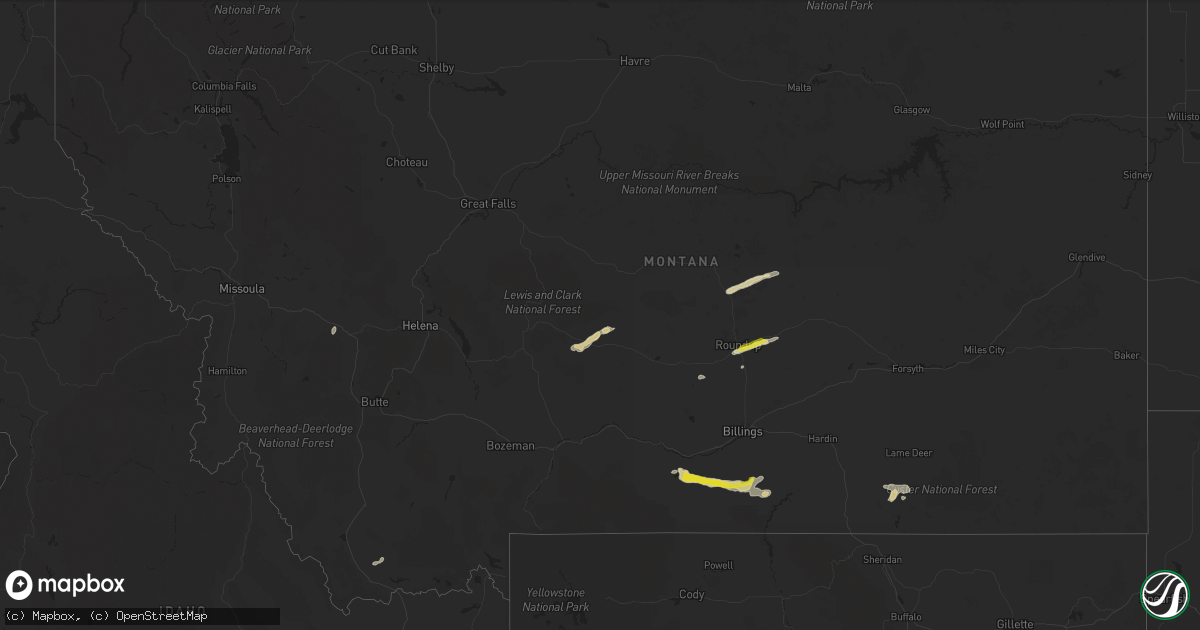
Hail Map in Montana on July 14, 2022
Get this storm
July 14 map
$229
one time, instant access
Download today. No call, no setup
Keep the $229
Bought the map and want the full workflow? Apply the entire $229 to a subscription within 7 days. None of it is wasted.
Every map, not just this one
This buys you this map. Subscription and you get every map we run, in the markets you choose from a few cities to whole states to nationwide. Plus real-time alerts the moment a storm fires.
Contact data
Name, contact info, occupancy, even credit band for addresses in the footprint. You go from where it hit to who to call.
Become the source they trust
Unlimited branding weather history reports on demand. You already have the documented answer ready for the property owner, and you are the one who showed up with it.
Property data and RoofTrace estimates
Pull up any address you have got, its value and the exact code rules for that jurisdiction, straight from One Click Code. Then RoofTrace estimates the squares, pitch, and roof value, priced the way you price.
Storm reports in Montana
Montana
| Date | Description |
|---|---|
| 07/14/20225:58 AM CDT | Awos station k1em echo. No lightning was observed at the time of gust. |
| 07/14/20224:38 AM CDT | Mesonet station mtden denton |
| 07/14/20222:00 AM CDT | At 700 PM MDT, a severe thunderstorm was located 9 miles west of Flatwillow, or 15 miles southwest of Winnett, moving northeast at 25 mph. HAZARD...60 mph wind gusts and quarter size hail. SOURCE...Radar indicated. IMPACT...Hail damage to vehicles is expected. Expect wind damage to roofs, siding, and trees. Locations impacted include... Winnett, Flatwillow and Petrolia Lake. |
| 07/14/20221:39 AM CDT | At 639 PM MDT, a severe thunderstorm was located 23 miles northwest of Roundup, moving northeast at 35 mph. HAZARD...60 mph wind gusts and quarter size hail. SOURCE...Radar indicated. IMPACT...Hail damage to vehicles is expected. Expect wind damage to roofs, siding, and trees. This severe thunderstorm will remain over mainly rural areas of northwestern Musselshell and northeastern Golden Valley Counties. |
| 07/13/202210:43 PM CDT | At 342 PM MDT, a severe thunderstorm was located near Joliet, or 19 miles southeast of Columbus, moving east at 35 mph. HAZARD...60 mph wind gusts and quarter size hail. SOURCE...Radar indicated. IMPACT...Hail damage to vehicles is expected. Expect wind damage to roofs, siding, and trees. Locations impacted include... Bridger, Joliet, Fromberg, Pryor, Edgar, Boyd and Rockvale. |
| 07/13/20228:27 PM CDT | A local report indicates 68 MPH wind near 7 NNE OTTER |
| 07/13/20228:25 PM CDT | A local report indicates 1.00 inch wind near 3 SSE WINNETT |
| 07/13/20227:59 PM CDT | A local report indicates 68 MPH wind near 7 NNE OTTER |
All States Impacted by Hail Map on July 14, 2022
Cities Impacted by Hail Map on July 14, 2022
- Steele, ND
- Robinson, ND
- Two Dot, MT
- Martinsdale, MT
- Reform, AL
- Millport, AL
- Lavina, MT
- Mansfield, TX
- Drake, ND
- Anamoose, ND
- Santo, TX
- Crystal River, FL
- Savannah, GA
- Port Wentworth, GA
- Bowie, TX
- Round Mountain, TX
- Willow City, TX
- Johnson City, TX
- Fredericksburg, TX
- Kissimmee, FL
- Middleboro, MA
- Vero Beach, FL
- Okeechobee, FL
- Bradenton, FL
- Oviedo, FL
- Dilley, TX
- Sheyenne, ND
- Saint Michael, ND
- San Antonio, TX
- Dublin, TX
- Gustine, TX
- Pottsville, TX
- Hamilton, TX
- Carlton, TX
- Bastrop, TX
- Bridger, MT
- Roberts, MT
- Columbus, MT
- Lodge Grass, MT
- Joliet, MT
- Fromberg, MT
- Hawthorne, FL
- Helotes, TX
- Gardner, ND
- Audubon, MN
- Lake Park, MN
- Sabin, MN
- Wolverton, MN
- Rothsay, MN
- Pelican Rapids, MN
- Barnesville, MN
- Princeton, MN
- Carver, MA
- Wareham, MA
- Plymouth, MA
- Birney, MT
- Bloomer, WI
- Cushing, MN
- Randall, MN
- Tolna, ND
- Pekin, ND
- Lafayette, AL
- Crowley, TX
- Burleson, TX
- Fort Worth, TX
- Moran, TX
- Cisco, TX
- Warwick, ND
- Oberon, ND
- Bristol, FL
- Rincon, GA
- Guyton, GA
- Bryson, TX
- Hardeeville, SC
- Brook Park, MN
- Hinckley, MN
- Hawley, MN
- Arthur, ND
- Grandin, ND
- Hillsboro, ND
- Argusville, ND
- Hunter, ND
- Harwood, ND
- Casselton, ND
- Galesburg, ND
- Blanchard, ND
- Mapleton, ND
- Goldthwaite, TX
- Park River, ND
- Comanche, TX
- Gorman, TX
- De Leon, TX
- Springfield, GA
- Walterboro, SC
- Manilla, IA
- Irwin, IA
- West, MS
- Saint Cloud, FL
- Eastland, TX
- Ranger, TX
- Comstock, WI
- Cumberland, WI
- Mullin, TX
- Lava Hot Springs, ID
- Dallas, WI
- Barron, WI
- Chetek, WI
- Cameron, WI
- Bancroft, ID
- Midlothian, TX
- Marshfield, MA
- Duxbury, MA
- Baird, TX
- Sarasota, FL
- Durant, MS
- Lexington, MS
- Early, TX
- Brownwood, TX
- Cotulla, TX
- Beatrice, NE
- Wymore, NE
- Blue Springs, NE
- Odell, NE
- Pierz, MN
- Little Falls, MN
- Fort Ripley, MN
- Vining, MN
- Parkers Prairie, MN
- Mount Pleasant, TX
- Mount Vernon, TX
- Ruffin, SC
- Winona, TX
- Kilgore, TX
- Gladewater, TX
- Mertzon, TX
- Carlsbad, TX
- Burkett, TX
- Carbon, TX
- San Saba, TX
- Foreston, MN
- Hillman, MN
- Milaca, MN
- Foley, MN
- Port Charlotte, FL
- Rotonda West, FL
- Englewood, FL
- Mount Dora, FL
- Decker, MT
- Live Oak, FL
- Bronte, TX
- Rochelle, TX
- Roundup, MT
- Cadott, WI
- Lakeville, MA
- Humarock, MA
- Berkley, MA
- Kingston, MA
- Norwell, MA
- Taunton, MA
- East Taunton, MA
- Bridgewater, MA
- Halifax, MA
- North Dighton, MA
- Hanson, MA
- Raynham, MA
- Pembroke, MA
- Dighton, MA
- Plympton, MA
- Farmingville, NY
- Centereach, NY
- Selden, NY
- Islandia, NY
- Central Islip, NY
- Bay Shore, NY
- Holtsville, NY
- Bohemia, NY
- Holbrook, NY
- Brentwood, NY
- Hauppauge, NY
- Nesconset, NY
- Ronkonkoma, NY
- Stephenville, TX
- New York Mills, MN
- Wadena, MN
- Henning, MN
- Deer Creek, MN
- Horace, ND
- Davenport, ND
- Kindred, ND
- West Fargo, ND
- Lima, MT
- Albany, TX
- Gold Creek, MT
- Brashear, TX
- Sulphur Springs, TX
- Blackwell, TX
- West Wareham, MA
- Rochester, MA
- Belgrade, ME
- Mount Vernon, ME
- Kents Hill, ME
- Grass Range, MT
- Winnett, MT
- Almena, WI
- Leesville, LA
- Crown King, AZ
- Clarendon, NC
- Tabor City, NC
- Granbury, TX
- Mora, MN
- Pine City, MN
- Grantsburg, WI
- Varnville, SC
- Apopka, FL
- Dolan Springs, AZ
- Red Oak, TX
- Lancaster, TX
- Ferris, TX
- Grand Prairie, TX
- Waxahachie, TX
- Arlington, TX
- Cedar Hill, TX
- Alvarado, TX
- Palmer, TX
- Venus, TX
- Desoto, TX
- Winter Garden, FL
- San Angelo, TX
- Coleman, TX
- Valera, TX
- Talpa, TX
- Novice, TX
- Lucedale, MS
- Orlando, FL
- Pearsall, TX
- Sweetwater, TX
- Turtle Lake, WI
- Jacksboro, TX
- Flagstaff, AZ
- Zephyr, TX
- Pisek, ND
- Buchanan Dam, TX
- Kingsland, TX
- Llano, TX
- Peach Springs, AZ
- Rowlett, TX
- Garland, TX
- Saint Croix Falls, WI
- Princeton, ME
- Onamia, MN
- Cleburne, TX
- Okatie, SC
- Bluffton, SC
- Tucson, AZ
- Ovalo, TX
- Clyde, TX
- Rush City, MN
- New Waverly, TX
- Huntsville, TX
- Hickman, NE
- Sterling, NE
- Firth, NE
- Adams, NE
- Sorrento, FL
- Beeville, TX
- Three Rivers, TX
- Robert Lee, TX
- Dalbo, MN
- McCool, MS
- Weir, MS
- Zolfo Springs, FL
- Clewiston, FL
- Labelle, FL
- Umatilla, FL
- Cedar Creek, TX
- Elgin, TX
- East Bridgewater, MA
- Lometa, TX
- Bend, TX
- Geneva, FL
- Goliad, TX
- Moore, TX
- Indiantown, FL
- Cape Coral, FL
- Falls City, TX
- Lampasas, TX
- Cross Plains, TX
- Casselberry, FL
- Lake Grove, NY
- Fort Totten, ND
- Scituate, MA
- Musselshell, MT


