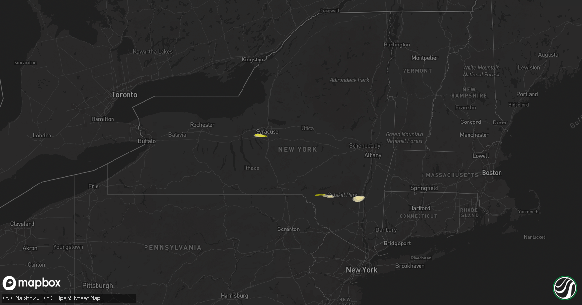
Hail Map in New York on July 13, 2022
Get this storm
July 13 map
$229
one time, instant access
Download today. No call, no setup
Keep the $229
Bought the map and want the full workflow? Apply the entire $229 to a subscription within 7 days. None of it is wasted.
Every map, not just this one
This buys you this map. Subscription and you get every map we run, in the markets you choose from a few cities to whole states to nationwide. Plus real-time alerts the moment a storm fires.
Contact data
Name, contact info, occupancy, even credit band for addresses in the footprint. You go from where it hit to who to call.
Become the source they trust
Unlimited branding weather history reports on demand. You already have the documented answer ready for the property owner, and you are the one who showed up with it.
Property data and RoofTrace estimates
Pull up any address you have got, its value and the exact code rules for that jurisdiction, straight from One Click Code. Then RoofTrace estimates the squares, pitch, and roof value, priced the way you price.
Storm reports in New York
New York
| Date | Description |
|---|---|
| 07/13/20226:20 PM CDT | Tree down on roadway. |
| 07/13/20226:20 PM CDT | State police came across a tree and wires down on roadway. |
| 07/13/20225:12 PM CDT | Wires down on roadway. |
| 07/13/20224:56 PM CDT | Power lines down on roadway. |
| 07/13/20224:53 PM CDT | Report from mping: quarter |
| 07/13/20224:52 PM CDT | Multiple downed trees with quarter sized hail. |
| 07/13/20224:51 PM CDT | Multiple trees and power lines down on falls rd. |
| 07/13/20224:50 PM CDT | Numerous trees down. Some tree 14 to 16 inches in diameter snapped. Nickel sized hail. |
| 07/13/20224:50 PM CDT | Trained spotter reported multiple trees down or split as well as dime sized hail. |
| 07/13/20224:49 PM CDT | A tree down on vehicle and a large tree uprooted in yard around roman ave and cranapple dr. |
| 07/13/20224:44 PM CDT | Tree and wires down on foster rd. Tree blocking entire road. |
| 07/13/20223:38 AM CDT | At 838 PM EDT, a severe thunderstorm was located near Olivebridge, or 7 miles west of Kingston, moving east at 30 mph. HAZARD...60 mph wind gusts. SOURCE...Radar indicated. IMPACT...Expect damage to roofs, siding, and trees. Locations impacted include... Kingston, Rhinebeck, Hyde Park, Hurley, Woodstock, Pine Plains, Red Hook, Millbrook, High Falls, Stanfordville, Tillson, West Hurley, Port Ewen, Kenneth L Wilson Campground, Lake Katrine, Staatsburg, Olivebridge, Esopus, Rosendale and Marbletown. |
| 07/13/20222:26 AM CDT | At 726 PM EDT, a severe thunderstorm was located near Willowemoc, or 12 miles north of Liberty, moving east at 30 mph. HAZARD...60 mph wind gusts and quarter size hail. SOURCE...Radar indicated. IMPACT...Hail damage to vehicles is expected. Expect wind damage to roofs, siding, and trees. Locations impacted include... Grahamsville, Willowemoc, Mongaup Pond Campground, Parkston, Lewbeach, Waneta Lake, Joscelyn, Debruce and Anderson. |
| 07/13/20222:22 AM CDT | At 721 PM EDT, a severe thunderstorm was located near Livingston Manor, or 10 miles north of Liberty, moving east at 30 mph. HAZARD...60 mph wind gusts. SOURCE...Radar indicated. IMPACT...Expect damage to roofs, siding, and trees. Locations impacted include... Hurley, Woodstock, Woodland Valley Campground, West Shokan, Kenneth L Wilson Campground, High Falls, West Hurley, Mount Tremper, Olivebridge, Kerhonkson, Marbletown, Denning, Cherrytown, Glenford, Palentown, Atwood, Oliverea, Shultis Corners, Pacama and Brodhead. |
| 07/13/20221:03 AM CDT | At 603 PM EDT, a severe thunderstorm was located near Syracuse, moving east at 30 mph. HAZARD...60 mph wind gusts and quarter size hail. SOURCE...Radar indicated. IMPACT...Hail damage to vehicles is expected. Expect wind damage to roofs, siding, and trees. Locations impacted include... Onondaga, Syracuse, De Witt, Sullivan, Solvay, Chittenango, Manlius, Fayetteville, Minoa and East Syracuse. |
| 07/13/202212:42 AM CDT | At 542 PM EDT, a severe thunderstorm was located near Skaneateles, or 8 miles northeast of Auburn, moving east at 25 mph. HAZARD...Quarter size hail. SOURCE...Radar indicated. IMPACT...Damage to vehicles is expected. Locations impacted include... Onondaga, Syracuse, Solvay, Skaneateles, Marcellus, Amboy, Camillus, Elbridge, New York State Fairgrounds and Galeville. |
| 07/12/20227:55 PM CDT | Tree and wires down broadway |
| 07/12/20227:50 PM CDT | Tree on trailer |
| 07/12/20227:50 PM CDT | Propane tank stuck by tree... Tank leaking... Lynette blvd |
| 07/12/20227:48 PM CDT | Tree on house |
| 07/12/20227:43 PM CDT | Route 209 closed at marbletown road due to a fallen tree and wires |
| 07/12/20227:42 PM CDT | Tree on wires route 209 |
| 07/12/20227:40 PM CDT | Tree and wires down atwood rd |
All States Impacted by Hail Map on July 13, 2022
Cities Impacted by Hail Map on July 13, 2022
- Hammond, MT
- Ringold, OK
- Dawsonville, GA
- Dewy Rose, GA
- Elberton, GA
- Broken Bow, OK
- Homer, MI
- Tekonsha, MI
- Litchfield, MI
- Holly Springs, MS
- Potts Camp, MS
- Mosby, MT
- Clarksdale, MS
- Lyon, MS
- Coahoma, MS
- Coffeeville, MS
- De Witt, AR
- Senatobia, MS
- Como, MS
- Schlater, MS
- Hickman, NE
- Roca, NE
- Lincoln, NE
- Bennet, NE
- Gainesville, GA
- Cumming, GA
- Queen City, TX
- Mena, AR
- Norman, AR
- Ringgold, LA
- Florien, LA
- Anacoco, LA
- Winona, KS
- Brewster, KS
- Colby, KS
- Levant, KS
- Atwood, KS
- Roanoke Rapids, NC
- Halifax, NC
- Mount Ida, AR
- Carlton, GA
- Firth, NE
- Alligator, MS
- Greenville, MS
- Ingomar, MT
- Musselshell, MT
- Pendleton, NC
- Amity, AR
- Cove, AR
- Shelby, MS
- Mound Bayou, MS
- Belhaven, NC
- Rayville, LA
- Burlington, NC
- Beaver Crossing, NE
- York, NE
- Exeter, NE
- Cordova, NE
- Friend, NE
- Long Branch, TX
- Carthage, TX
- Donaldson, AR
- Enterprise, LA
- Harrisonburg, LA
- Lexington, GA
- Edwards, MS
- Utica, MS
- Lewisville, AR
- Taylor, AR
- Keithville, LA
- Waskom, TX
- Karnack, TX
- Grenada, MS
- Scobey, MS
- Holcomb, MS
- Cascilla, MS
- Greenwood, MS
- Carrollton, MS
- Charleston, MS
- Tillatoba, MS
- Odell, NE
- Wright City, OK
- Brent, AL
- Centreville, AL
- Ashland, VA
- Glen Allen, VA
- Littleton, NC
- Oakland, MS
- Enid, MS
- Livingston Manor, NY
- Claryville, NY
- Roscoe, NY
- Utica, NE
- Milford, NE
- Seward, NE
- Goehner, NE
- Jonesville, MI
- Coushatta, LA
- Elm Grove, LA
- Waco, NE
- Walhalla, SC
- Crete, NE
- Newhope, AR
- Umpire, AR
- South Hill, VA
- Clarksville, VA
- Bullock, NC
- Boydton, VA
- Baskerville, VA
- Arkadelphia, AR
- Jefferson City, MT
- Lincolnton, NC
- Maiden, NC
- Denver, NC
- Hampton, AR
- Sheridan, AR
- Valliant, OK
- Garvin, OK
- West Yellowstone, MT
- Thornton, AR
- Doddridge, AR
- Rattan, OK
- Meridian, MS
- Newbern, AL
- Uniontown, AL
- Faunsdale, AL
- Lithonia, GA
- Zwolle, LA
- Many, LA
- Noble, LA
- Delhi, LA
- El Dorado, AR
- Daingerfield, TX
- Jamestown, LA
- Castor, LA
- Cades, SC
- Kingstree, SC
- Jefferson, TX
- Pittsburg, TX
- Diller, NE
- Tutwiler, MS
- Drew, MS
- Newellton, LA
- Rosston, AR
- Buckner, AR
- Goodman, MS
- Camden, MS
- Pickens, MS
- Warrenton, NC
- Roy, MT
- Dierks, AR
- De Queen, AR
- Mount Pleasant, TX
- Royal, AR
- Hot Springs National Park, AR
- Banks, AR
- Hampton, GA
- Jonesboro, GA
- Leesburg, TX
- Goldonna, LA
- Winnfield, LA
- Buffalo, MT
- Joaquin, TX
- Farmerville, LA
- Bernice, LA
- Choudrant, LA
- Eudora, AR
- Brusett, MT
- Duck Hill, MS
- Summit, MS
- Jordan, MT
- Mesa, AZ
- Gilbert, AZ
- Belgrade, MT
- Skaneateles, NY
- Elbridge, NY
- Syracuse, NY
- Marcellus, NY
- Wickes, AR
- Vandervoort, AR
- Grannis, AR
- Gillham, AR
- Deadwood, SD
- Waterford, MS
- Hugo, OK
- Zolfo Springs, FL
- Arcadia, FL
- McCool Junction, NE
- Waynesboro, MS
- Thonotosassa, FL
- Plant City, FL
- Dover, FL
- Lakeland, FL
- Orlando, FL
- Kirby, AR
- Logansport, LA
- Magnolia, AR
- Waldo, AR
- McNeil, AR
- Fouke, AR
- Comer, GA
- Shreveport, LA
- Leoti, KS
- Wallace, KS
- Sharon Springs, KS
- Tribune, KS
- Davenport, FL
- Stamps, AR
- Saline, LA
- Cloutierville, LA
- Lena, LA
- Eupora, MS
- Stewart, MS
- Center, TX
- Eutaw, AL
- Provencal, LA
- Punta Gorda, FL
- North Fort Myers, FL
- Oak Grove, LA
- Pioneer, LA
- Wharton, TX
- Trout, LA
- Wilmot, AR
- Grady, AR
- Texarkana, AR
- Nemaha, NE
- Brownville, NE
- Groveland, FL
- Yalaha, FL
- Howey In The Hills, FL
- Bunnell, FL
- Gloster, LA
- Tenaha, TX
- Smoaks, SC
- Williams, SC
- Ruffin, SC
- Eros, LA
- Nacogdoches, TX
- Ozona, TX
- Gore Springs, MS
- Summerfield, LA
- Fort Supply, OK
- Woodward, OK
- Hurley, NY
- West Hurley, NY
- Kingston, NY
- Ruleville, MS
- Lewistown, MT
- Stonewall, LA
- Rodessa, LA
- Ruth, MS
- Boling, TX
- Tetonia, ID
- Islandton, SC
- McCool, MS
- Ethel, MS
- Colbert, GA
- Louise, TX
- Monticello, MS
- Colfax, LA
- El Campo, TX
- Comstock, TX
- Clewiston, FL
- Hobson, MT
- Lake Providence, LA
- Sells, AZ
- Frierson, LA
- Mansfield, LA
- Douglass, TX
- Natchitoches, LA
- Hemphill, TX
- Tavares, FL
- Timpson, TX
- Umatilla, FL
- Eustis, FL
- Lillie, LA
- Junction City, AR
- Bloomington, NY
- Port Ewen, NY
- Cottekill, NY
- Stone Ridge, NY
- Olivebridge, NY
- Bogue Chitto, MS
- Hartwell, GA
- Rhinebeck, NY
- Ulster Park, NY
- Rosendale, NY
- Alcolu, SC
- Gable, SC
- Bivins, TX
- Vicksburg, MS
- Itta Bena, MS
- Garwood, TX
- Hallettsville, TX
- Boyle, MS
- Louin, MS
- Pierson, FL
- Seville, FL
- Keatchie, LA
- Grand Cane, LA
- Greenwood, LA
- McCarley, MS
- Lodge, SC
- Gunnison, MS
- Snow Lake, AR
- Wimauma, FL
- Bowman, GA
- Marshall, TX
- Hallsville, TX
- Terry, MS
- Raymond, MS
- Brady, TX
- Tallulah, LA
- Mount Vernon, TX
- San Augustine, TX
- Immokalee, FL
- Port Gibson, MS
- Alexis, NC
- Iron Station, NC
- Stanley, NC
- Cleveland, MS
- Doddsville, MS
- Holly Grove, AR
- Marvell, AR
- Dubberly, LA
- Brookhaven, MS
- Hernando, MS
- De Kalb, TX
- Griffin, GA
- Williamson, GA
- Mcdonough, GA
- Lorman, MS
- Brooks, GA
- Sparkman, AR
- Sontag, MS
- Leesburg, FL
- Felt, ID
- Lavonia, GA
- Alva, FL
- Brandon, FL
- Tampa, FL
- Riverview, FL
- Portland, AR
- Sondheimer, LA
- Epps, LA
- Greensboro, GA
- Hickory, MS
- Chunky, MS
- Dodson, LA
- Jena, LA
- Jefferson, GA
- Mora, LA
- Flatwoods, LA
- West Monroe, LA
- Bentley, LA
- Dry Prong, LA
- Monticello, AR
- Byram, MS
- Waverly, AL
- Mize, MS
- Raleigh, MS
- Naples, FL
- Joliet, MT
- Columbus, MT
- Laurel, MT
- Park City, MT
- Nedrow, NY
- East Branch, NY
- Downsville, NY


