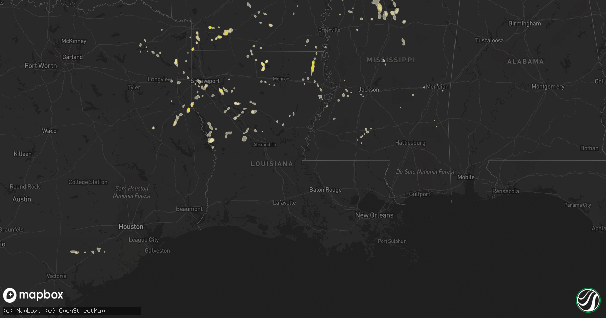
Hail Map in Louisiana on July 13, 2022
Get this storm
July 13 map
$229
one time, instant access
Download today. No call, no setup
Keep the $229
Bought the map and want the full workflow? Apply the entire $229 to a subscription within 7 days. None of it is wasted.
Every map, not just this one
This buys you this map. Subscription and you get every map we run, in the markets you choose from a few cities to whole states to nationwide. Plus real-time alerts the moment a storm fires.
Contact data
Name, contact info, occupancy, even credit band for addresses in the footprint. You go from where it hit to who to call.
Become the source they trust
Unlimited branding weather history reports on demand. You already have the documented answer ready for the property owner, and you are the one who showed up with it.
Property data and RoofTrace estimates
Pull up any address you have got, its value and the exact code rules for that jurisdiction, straight from One Click Code. Then RoofTrace estimates the squares, pitch, and roof value, priced the way you price.
Storm reports in Louisiana
Louisiana
| Date | Description |
|---|---|
| 07/13/20226:50 PM CDT | Corrects previous hail report from 5 w farmerville. Public reports hail of very large hail at lake d arbonne state park. |
| 07/13/20225:19 PM CDT | Trees down on philley lane. |
| 07/13/20225:15 PM CDT | Trees down on hurt rd. |
| 07/13/20225:15 PM CDT | Three trees down on hwy 17 south. |
| 07/13/20225:08 PM CDT | Trees down on brake rd. |
| 07/13/20224:56 PM CDT | Multiple trees down in pioneer. |
| 07/13/20224:56 PM CDT | Nickel to quarter size hail in pioneer. |
| 07/13/20224:50 PM CDT | Trees down on forest cemetery rd. |
| 07/13/20224:44 PM CDT | Powerlines down on hwy 589. |
| 07/13/20224:20 PM CDT | Quarter size hail fell along philley ln. |
| 07/13/20224:19 PM CDT | Corrects previous tstm wnd dmg report from 2 ene oak grove. Trees down on philley lane. |
| 07/13/202211:00 AM CDT | Sheriff department reports numerous trees and powerlines down across sabine parish... Including the city of many. |
| 07/13/20226:18 AM CDT | At 1117 PM CDT, a severe thunderstorm was located 8 miles northwest of Toledo Bend Dam, moving south at 35 mph. HAZARD...60 mph wind gusts and quarter size hail. SOURCE...Radar indicated. IMPACT...Hail damage to vehicles is expected. Expect wind damage to roofs, siding, and trees. Locations impacted include... Hemphill, Columbus, Fairmount and Yellowpine. |
| 07/13/20225:42 AM CDT | At 1041 PM CDT, a severe thunderstorm was located near Hutton, or 7 miles northeast of Slagle, moving south at 20 mph. HAZARD...60 mph wind gusts and quarter size hail. SOURCE...Radar indicated. IMPACT...Hail damage to vehicles is expected. Expect wind damage to roofs, siding, and trees. Locations impacted include... Slagle, Fort Polk, Lacamp, Kurthwood, Leander, Sieper, Hutton, Clifton and Simpson. |
| 07/13/20224:04 AM CDT | At 904 PM CDT, a severe thunderstorm was located near Natchitoches, moving south at 5 mph. HAZARD...60 mph wind gusts and quarter size hail. SOURCE...Radar indicated. IMPACT...Hail damage to vehicles is expected. Expect wind damage to roofs, siding, and trees. Locations impacted include... Natchitoches, Clarence, Grand Ecore and St. Maurice. |
| 07/13/20223:26 AM CDT | At 826 PM CDT, a severe thunderstorm was located near Shreveport, moving southeast at 5 mph. HAZARD...60 mph wind gusts and half dollar size hail. SOURCE...Radar indicated. IMPACT...Hail damage to vehicles is expected. Expect wind damage to roofs, siding, and trees. Locations impacted include... Shreveport, Greenwood, Cross Lake, Forbing and Keithville. |
| 07/13/20223:16 AM CDT | At 815 PM CDT, severe thunderstorms were located along a line extending from near Lawson to near Junction City to 7 miles west of Bernice, moving east at 20 mph. HAZARD...60 mph wind gusts and quarter size hail. SOURCE...Radar indicated. IMPACT...Hail damage to vehicles is expected. Expect wind damage to roofs, siding, and trees. Locations impacted include... Bernice, Strong, Urbana, Lawson, Cooley, Junction City, Lisbon, Spearsville, Lillie, Aurelle, Taylorville, Hillsboro, Corney Lake, Lockhart and Catesville. |
| 07/13/20222:58 AM CDT | At 757 PM CDT, a severe thunderstorm was located 8 miles southeast of Shreveport, moving southeast at 5 mph. HAZARD...60 mph wind gusts and half dollar size hail. SOURCE...Radar indicated. IMPACT...Hail damage to vehicles is expected. Expect wind damage to roofs, siding, and trees. Locations impacted include... Shreveport, Taylortown, Robson, Frierson and Forbing. |
| 07/13/20222:15 AM CDT | At 715 PM CDT, a severe thunderstorm was located 8 miles west of Ringgold, or 19 miles southeast of Bossier City, moving north at 5 mph. HAZARD...60 mph wind gusts and quarter size hail. SOURCE...Radar indicated. IMPACT...Hail damage to vehicles is expected. Expect wind damage to roofs, siding, and trees. Locations impacted include... Lake Bistineau South, Elm Grove, Mc Dade, Curtis and Koran. |
| 07/13/20222:10 AM CDT | At 709 PM CDT, a severe thunderstorm was located near Joaquin, or 12 miles north of Center, and is nearly stationary. HAZARD...60 mph wind gusts and quarter size hail. SOURCE...Radar indicated. IMPACT...Hail damage to vehicles is expected. Expect wind damage to roofs, siding, and trees. Locations impacted include... Logansport, Joaquin, Deadwood and Paxton. |
| 07/13/20221:50 AM CDT | At 649 PM CDT, a severe thunderstorm was located near Ringgold, or 23 miles south of Minden, and is nearly stationary. HAZARD...60 mph wind gusts and quarter size hail. SOURCE...Radar indicated. IMPACT...Hail damage to vehicles is expected. Expect wind damage to roofs, siding, and trees. Locations impacted include... Ringgold, Jamestown, Lake Bistineau South, Lake Bistineau North and Plum Orchard Landing. |
| 07/12/202211:54 PM CDT | At 454 PM CDT, a severe thunderstorm was located near Darnell, or 12 miles west of Transylvania, moving south at 30 mph. HAZARD...Ping pong ball size hail and 60 mph wind gusts. SOURCE...Radar indicated. IMPACT...People and animals outdoors will be injured. Expect hail damage to roofs, siding, windows, and vehicles. Expect wind damage to roofs, siding, and trees. This severe thunderstorm will be near... Darnell around 500 PM CDT. Monticello around 510 PM CDT. Warden around 520 PM CDT. Delhi, Waverly and Tendal around 535 PM CDT.Other locations impacted by this severe thunderstorm include Pioneerand Epps. |
| 07/12/202211:00 PM CDT | Corrects previous tstm wnd dmg report from many. Sheriff department reports numerous trees and powerlines down across sabine parish... Including the city of many. |
| 07/12/20229:25 PM CDT | Reports of large tree down on bucks grocery road... Just south of the grand ecore community. |
| 07/12/20227:56 PM CDT | A picture was posted to social media of a tree that was blown down across ellerbe road south of norris ferry road. |
| 07/12/20227:30 PM CDT | Public report of hail around quarter size on barnes bridge road... Resulting in a cracked windshield. |
| 07/12/20227:10 PM CDT | Report of a fallen limb on a car in the town of newellton. |
| 07/12/20227:10 PM CDT | Via social media... Damage to a home on shackleford road in newellton. |
All States Impacted by Hail Map on July 13, 2022
Cities Impacted by Hail Map on July 13, 2022
- Hammond, MT
- Ringold, OK
- Dawsonville, GA
- Dewy Rose, GA
- Elberton, GA
- Broken Bow, OK
- Homer, MI
- Tekonsha, MI
- Litchfield, MI
- Holly Springs, MS
- Potts Camp, MS
- Mosby, MT
- Clarksdale, MS
- Lyon, MS
- Coahoma, MS
- Coffeeville, MS
- De Witt, AR
- Senatobia, MS
- Como, MS
- Schlater, MS
- Hickman, NE
- Roca, NE
- Lincoln, NE
- Bennet, NE
- Gainesville, GA
- Cumming, GA
- Queen City, TX
- Mena, AR
- Norman, AR
- Ringgold, LA
- Florien, LA
- Anacoco, LA
- Winona, KS
- Brewster, KS
- Colby, KS
- Levant, KS
- Atwood, KS
- Roanoke Rapids, NC
- Halifax, NC
- Mount Ida, AR
- Carlton, GA
- Firth, NE
- Alligator, MS
- Greenville, MS
- Ingomar, MT
- Musselshell, MT
- Pendleton, NC
- Amity, AR
- Cove, AR
- Shelby, MS
- Mound Bayou, MS
- Belhaven, NC
- Rayville, LA
- Burlington, NC
- Beaver Crossing, NE
- York, NE
- Exeter, NE
- Cordova, NE
- Friend, NE
- Long Branch, TX
- Carthage, TX
- Donaldson, AR
- Enterprise, LA
- Harrisonburg, LA
- Lexington, GA
- Edwards, MS
- Utica, MS
- Lewisville, AR
- Taylor, AR
- Keithville, LA
- Waskom, TX
- Karnack, TX
- Grenada, MS
- Scobey, MS
- Holcomb, MS
- Cascilla, MS
- Greenwood, MS
- Carrollton, MS
- Charleston, MS
- Tillatoba, MS
- Odell, NE
- Wright City, OK
- Brent, AL
- Centreville, AL
- Ashland, VA
- Glen Allen, VA
- Littleton, NC
- Oakland, MS
- Enid, MS
- Livingston Manor, NY
- Claryville, NY
- Roscoe, NY
- Utica, NE
- Milford, NE
- Seward, NE
- Goehner, NE
- Jonesville, MI
- Coushatta, LA
- Elm Grove, LA
- Waco, NE
- Walhalla, SC
- Crete, NE
- Newhope, AR
- Umpire, AR
- South Hill, VA
- Clarksville, VA
- Bullock, NC
- Boydton, VA
- Baskerville, VA
- Arkadelphia, AR
- Jefferson City, MT
- Lincolnton, NC
- Maiden, NC
- Denver, NC
- Hampton, AR
- Sheridan, AR
- Valliant, OK
- Garvin, OK
- West Yellowstone, MT
- Thornton, AR
- Doddridge, AR
- Rattan, OK
- Meridian, MS
- Newbern, AL
- Uniontown, AL
- Faunsdale, AL
- Lithonia, GA
- Zwolle, LA
- Many, LA
- Noble, LA
- Delhi, LA
- El Dorado, AR
- Daingerfield, TX
- Jamestown, LA
- Castor, LA
- Cades, SC
- Kingstree, SC
- Jefferson, TX
- Pittsburg, TX
- Diller, NE
- Tutwiler, MS
- Drew, MS
- Newellton, LA
- Rosston, AR
- Buckner, AR
- Goodman, MS
- Camden, MS
- Pickens, MS
- Warrenton, NC
- Roy, MT
- Dierks, AR
- De Queen, AR
- Mount Pleasant, TX
- Royal, AR
- Hot Springs National Park, AR
- Banks, AR
- Hampton, GA
- Jonesboro, GA
- Leesburg, TX
- Goldonna, LA
- Winnfield, LA
- Buffalo, MT
- Joaquin, TX
- Farmerville, LA
- Bernice, LA
- Choudrant, LA
- Eudora, AR
- Brusett, MT
- Duck Hill, MS
- Summit, MS
- Jordan, MT
- Mesa, AZ
- Gilbert, AZ
- Belgrade, MT
- Skaneateles, NY
- Elbridge, NY
- Syracuse, NY
- Marcellus, NY
- Wickes, AR
- Vandervoort, AR
- Grannis, AR
- Gillham, AR
- Deadwood, SD
- Waterford, MS
- Hugo, OK
- Zolfo Springs, FL
- Arcadia, FL
- McCool Junction, NE
- Waynesboro, MS
- Thonotosassa, FL
- Plant City, FL
- Dover, FL
- Lakeland, FL
- Orlando, FL
- Kirby, AR
- Logansport, LA
- Magnolia, AR
- Waldo, AR
- McNeil, AR
- Fouke, AR
- Comer, GA
- Shreveport, LA
- Leoti, KS
- Wallace, KS
- Sharon Springs, KS
- Tribune, KS
- Davenport, FL
- Stamps, AR
- Saline, LA
- Cloutierville, LA
- Lena, LA
- Eupora, MS
- Stewart, MS
- Center, TX
- Eutaw, AL
- Provencal, LA
- Punta Gorda, FL
- North Fort Myers, FL
- Oak Grove, LA
- Pioneer, LA
- Wharton, TX
- Trout, LA
- Wilmot, AR
- Grady, AR
- Texarkana, AR
- Nemaha, NE
- Brownville, NE
- Groveland, FL
- Yalaha, FL
- Howey In The Hills, FL
- Bunnell, FL
- Gloster, LA
- Tenaha, TX
- Smoaks, SC
- Williams, SC
- Ruffin, SC
- Eros, LA
- Nacogdoches, TX
- Ozona, TX
- Gore Springs, MS
- Summerfield, LA
- Fort Supply, OK
- Woodward, OK
- Hurley, NY
- West Hurley, NY
- Kingston, NY
- Ruleville, MS
- Lewistown, MT
- Stonewall, LA
- Rodessa, LA
- Ruth, MS
- Boling, TX
- Tetonia, ID
- Islandton, SC
- McCool, MS
- Ethel, MS
- Colbert, GA
- Louise, TX
- Monticello, MS
- Colfax, LA
- El Campo, TX
- Comstock, TX
- Clewiston, FL
- Hobson, MT
- Lake Providence, LA
- Sells, AZ
- Frierson, LA
- Mansfield, LA
- Douglass, TX
- Natchitoches, LA
- Hemphill, TX
- Tavares, FL
- Timpson, TX
- Umatilla, FL
- Eustis, FL
- Lillie, LA
- Junction City, AR
- Bloomington, NY
- Port Ewen, NY
- Cottekill, NY
- Stone Ridge, NY
- Olivebridge, NY
- Bogue Chitto, MS
- Hartwell, GA
- Rhinebeck, NY
- Ulster Park, NY
- Rosendale, NY
- Alcolu, SC
- Gable, SC
- Bivins, TX
- Vicksburg, MS
- Itta Bena, MS
- Garwood, TX
- Hallettsville, TX
- Boyle, MS
- Louin, MS
- Pierson, FL
- Seville, FL
- Keatchie, LA
- Grand Cane, LA
- Greenwood, LA
- McCarley, MS
- Lodge, SC
- Gunnison, MS
- Snow Lake, AR
- Wimauma, FL
- Bowman, GA
- Marshall, TX
- Hallsville, TX
- Terry, MS
- Raymond, MS
- Brady, TX
- Tallulah, LA
- Mount Vernon, TX
- San Augustine, TX
- Immokalee, FL
- Port Gibson, MS
- Alexis, NC
- Iron Station, NC
- Stanley, NC
- Cleveland, MS
- Doddsville, MS
- Holly Grove, AR
- Marvell, AR
- Dubberly, LA
- Brookhaven, MS
- Hernando, MS
- De Kalb, TX
- Griffin, GA
- Williamson, GA
- Mcdonough, GA
- Lorman, MS
- Brooks, GA
- Sparkman, AR
- Sontag, MS
- Leesburg, FL
- Felt, ID
- Lavonia, GA
- Alva, FL
- Brandon, FL
- Tampa, FL
- Riverview, FL
- Portland, AR
- Sondheimer, LA
- Epps, LA
- Greensboro, GA
- Hickory, MS
- Chunky, MS
- Dodson, LA
- Jena, LA
- Jefferson, GA
- Mora, LA
- Flatwoods, LA
- West Monroe, LA
- Bentley, LA
- Dry Prong, LA
- Monticello, AR
- Byram, MS
- Waverly, AL
- Mize, MS
- Raleigh, MS
- Naples, FL
- Joliet, MT
- Columbus, MT
- Laurel, MT
- Park City, MT
- Nedrow, NY
- East Branch, NY
- Downsville, NY


