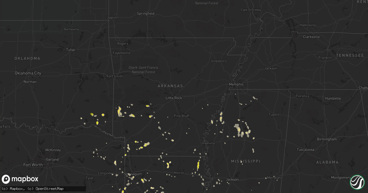
Hail Map in Arkansas on July 13, 2022
Get this storm
July 13 map
$229
one time, instant access
Download today. No call, no setup
Keep the $229
Bought the map and want the full workflow? Apply the entire $229 to a subscription within 7 days. None of it is wasted.
Every map, not just this one
This buys you this map. Subscription and you get every map we run, in the markets you choose from a few cities to whole states to nationwide. Plus real-time alerts the moment a storm fires.
Contact data
Name, contact info, occupancy, even credit band for addresses in the footprint. You go from where it hit to who to call.
Become the source they trust
Unlimited branding weather history reports on demand. You already have the documented answer ready for the property owner, and you are the one who showed up with it.
Property data and RoofTrace estimates
Pull up any address you have got, its value and the exact code rules for that jurisdiction, straight from One Click Code. Then RoofTrace estimates the squares, pitch, and roof value, priced the way you price.
Storm reports in Arkansas
Arkansas
| Date | Description |
|---|---|
| 07/13/20226:35 PM CDT | Large tree down on miller county road 9... Near the pisgah baptist church... South of fouke. |
| 07/13/20226:25 PM CDT | Two large trees down at residence on miller county road 481. One tree was uprooted and the other was snapped. |
| 07/13/20226:25 PM CDT | Quarter size hail reported on hwy 29 at the hempstead and lafayette county line. |
| 07/13/20226:25 PM CDT | Arkansas state police reported large limbs across state hwy 29... About 5 miles nnw of lewisville... Along with quarter size hail. |
| 07/13/20225:30 PM CDT | A local report indicates 1.00 inch wind near DAISY |
| 07/13/20221:59 AM CDT | At 659 PM CDT, a severe thunderstorm was located near Lanark, or 9 miles southeast of Hampton, moving south at 5 mph. HAZARD...60 mph wind gusts and quarter size hail. SOURCE...Radar indicated. IMPACT...Hail damage to vehicles is expected. Expect wind damage to roofs, siding, and trees. Locations impacted include... Hermitage... Harrell... Lanark... Jersey... Gravelridge... |
| 07/13/20221:54 AM CDT | At 654 PM CDT, a severe thunderstorm was located over Caddo Valley, or near Arkadelphia, moving southeast at 5 mph. HAZARD...60 mph wind gusts and quarter size hail. SOURCE...Radar indicated. IMPACT...Hail damage to vehicles is expected. Expect wind damage to roofs, siding, and trees. Locations impacted include... Arkadelphia... Caddo Valley... Gum Springs in Clark County... Richwoods... DeGray Lake State Park... Joan... Lower Lake Recreation Area... This includes Interstate 30 between mile markers 65 and 81. |
| 07/13/20221:32 AM CDT | At 631 PM CDT, a severe thunderstorm was located over Fouke, or 15 miles southeast of Texarkana, and is nearly stationary. HAZARD...60 mph wind gusts and quarter size hail. SOURCE...Radar indicated. IMPACT...Hail damage to vehicles is expected. Expect wind damage to roofs, siding, and trees. Locations impacted include... Fouke and Fort Lynn. |
| 07/13/20221:29 AM CDT | At 629 PM CDT, a severe thunderstorm was located near Lewisville, and is nearly stationary. HAZARD...60 mph wind gusts and quarter size hail. SOURCE...Public. IMPACT...Hail damage to vehicles is expected. Expect wind damage to roofs, siding, and trees. Locations impacted include... Stamps, Lewisville, Buckner, Patmos, Spirit Lake and Piney Grove. |
| 07/13/202212:28 AM CDT | At 528 PM CDT, a severe thunderstorm was located near Smithland, or 7 miles southeast of Stamps, moving northeast at 5 mph. HAZARD...60 mph wind gusts and quarter size hail. SOURCE...Radar indicated. IMPACT...Hail damage to vehicles is expected. Expect wind damage to roofs, siding, and trees. Locations impacted include... Magnolia, Stamps, Waldo, McNeil, Buckner, Smithland, Mount Vernon, Cornelius, Lerch, McKamie and Lamartine. |
| 07/13/202212:15 AM CDT | At 515 PM CDT, a severe thunderstorm was located over Daisy, or 12 miles northwest of Murfreesboro, moving southeast at 5 mph. HAZARD...60 mph wind gusts and quarter size hail. SOURCE...Radar indicated. IMPACT...Hail damage to vehicles is expected. Expect wind damage to roofs, siding, and trees. Locations impacted include... Daisy... Narrows Dam... Daisy State Park... Bear Creek Public Use Area... Kirby... New Hope in Pike County... Langley... |
| 07/12/202211:50 PM CDT | At 449 PM CDT, a severe thunderstorm was located near Wickes, or 13 miles west of Umpire, moving southeast at 5 mph. Other scattered storms were rapidly developing northward toward Mena, and may become severe. HAZARD...60 mph wind gusts and quarter size hail. SOURCE...Radar indicated. IMPACT...Hail damage to vehicles is expected. Expect wind damage to roofs, siding, and trees. Locations impacted include... Mena... Wickes... Grannis... Vandervoort... Shady... Hartley... Cossatot River State Park... Bard Springs Recreation Area... Caney Creek Wilderness... Polk County Fairgrounds... Mena Intermountain Airport... Mccauley... Shady Lake Recreation Area... Hatton... Roaring Branch Natural Area... Dallas... Nunley... |
| 07/12/202211:19 PM CDT | At 418 PM CDT, a severe thunderstorm was located near Oak Grove, or 10 miles northwest of Lake Providence, moving east at 10 mph. HAZARD...60 mph wind gusts and quarter size hail. SOURCE...Radar indicated. IMPACT...Hail damage to vehicles is expected. Expect wind damage to roofs, siding, and trees. This severe thunderstorm will be near... Millikin around 440 PM CDT. Shelburn around 450 PM CDT. Lake Providence around 510 PM CDT.Other locations impacted by this severe thunderstorm includeKilbourne and Forest. |
| 07/12/202210:58 PM CDT | At 358 PM CDT, a severe thunderstorm was located 7 miles west of Umpire, moving southeast at 10 mph. HAZARD...60 mph wind gusts and penny size hail. SOURCE...Radar indicated. IMPACT...Expect damage to roofs, siding, and trees. Locations impacted include... Umpire and Burg. |
| 07/12/20227:00 PM CDT | A local report indicates 1.00 inch wind near 2 NNE DE GRAY |
All States Impacted by Hail Map on July 13, 2022
Cities Impacted by Hail Map on July 13, 2022
- Hammond, MT
- Ringold, OK
- Dawsonville, GA
- Dewy Rose, GA
- Elberton, GA
- Broken Bow, OK
- Homer, MI
- Tekonsha, MI
- Litchfield, MI
- Holly Springs, MS
- Potts Camp, MS
- Mosby, MT
- Clarksdale, MS
- Lyon, MS
- Coahoma, MS
- Coffeeville, MS
- De Witt, AR
- Senatobia, MS
- Como, MS
- Schlater, MS
- Hickman, NE
- Roca, NE
- Lincoln, NE
- Bennet, NE
- Gainesville, GA
- Cumming, GA
- Queen City, TX
- Mena, AR
- Norman, AR
- Ringgold, LA
- Florien, LA
- Anacoco, LA
- Winona, KS
- Brewster, KS
- Colby, KS
- Levant, KS
- Atwood, KS
- Roanoke Rapids, NC
- Halifax, NC
- Mount Ida, AR
- Carlton, GA
- Firth, NE
- Alligator, MS
- Greenville, MS
- Ingomar, MT
- Musselshell, MT
- Pendleton, NC
- Amity, AR
- Cove, AR
- Shelby, MS
- Mound Bayou, MS
- Belhaven, NC
- Rayville, LA
- Burlington, NC
- Beaver Crossing, NE
- York, NE
- Exeter, NE
- Cordova, NE
- Friend, NE
- Long Branch, TX
- Carthage, TX
- Donaldson, AR
- Enterprise, LA
- Harrisonburg, LA
- Lexington, GA
- Edwards, MS
- Utica, MS
- Lewisville, AR
- Taylor, AR
- Keithville, LA
- Waskom, TX
- Karnack, TX
- Grenada, MS
- Scobey, MS
- Holcomb, MS
- Cascilla, MS
- Greenwood, MS
- Carrollton, MS
- Charleston, MS
- Tillatoba, MS
- Odell, NE
- Wright City, OK
- Brent, AL
- Centreville, AL
- Ashland, VA
- Glen Allen, VA
- Littleton, NC
- Oakland, MS
- Enid, MS
- Livingston Manor, NY
- Claryville, NY
- Roscoe, NY
- Utica, NE
- Milford, NE
- Seward, NE
- Goehner, NE
- Jonesville, MI
- Coushatta, LA
- Elm Grove, LA
- Waco, NE
- Walhalla, SC
- Crete, NE
- Newhope, AR
- Umpire, AR
- South Hill, VA
- Clarksville, VA
- Bullock, NC
- Boydton, VA
- Baskerville, VA
- Arkadelphia, AR
- Jefferson City, MT
- Lincolnton, NC
- Maiden, NC
- Denver, NC
- Hampton, AR
- Sheridan, AR
- Valliant, OK
- Garvin, OK
- West Yellowstone, MT
- Thornton, AR
- Doddridge, AR
- Rattan, OK
- Meridian, MS
- Newbern, AL
- Uniontown, AL
- Faunsdale, AL
- Lithonia, GA
- Zwolle, LA
- Many, LA
- Noble, LA
- Delhi, LA
- El Dorado, AR
- Daingerfield, TX
- Jamestown, LA
- Castor, LA
- Cades, SC
- Kingstree, SC
- Jefferson, TX
- Pittsburg, TX
- Diller, NE
- Tutwiler, MS
- Drew, MS
- Newellton, LA
- Rosston, AR
- Buckner, AR
- Goodman, MS
- Camden, MS
- Pickens, MS
- Warrenton, NC
- Roy, MT
- Dierks, AR
- De Queen, AR
- Mount Pleasant, TX
- Royal, AR
- Hot Springs National Park, AR
- Banks, AR
- Hampton, GA
- Jonesboro, GA
- Leesburg, TX
- Goldonna, LA
- Winnfield, LA
- Buffalo, MT
- Joaquin, TX
- Farmerville, LA
- Bernice, LA
- Choudrant, LA
- Eudora, AR
- Brusett, MT
- Duck Hill, MS
- Summit, MS
- Jordan, MT
- Mesa, AZ
- Gilbert, AZ
- Belgrade, MT
- Skaneateles, NY
- Elbridge, NY
- Syracuse, NY
- Marcellus, NY
- Wickes, AR
- Vandervoort, AR
- Grannis, AR
- Gillham, AR
- Deadwood, SD
- Waterford, MS
- Hugo, OK
- Zolfo Springs, FL
- Arcadia, FL
- McCool Junction, NE
- Waynesboro, MS
- Thonotosassa, FL
- Plant City, FL
- Dover, FL
- Lakeland, FL
- Orlando, FL
- Kirby, AR
- Logansport, LA
- Magnolia, AR
- Waldo, AR
- McNeil, AR
- Fouke, AR
- Comer, GA
- Shreveport, LA
- Leoti, KS
- Wallace, KS
- Sharon Springs, KS
- Tribune, KS
- Davenport, FL
- Stamps, AR
- Saline, LA
- Cloutierville, LA
- Lena, LA
- Eupora, MS
- Stewart, MS
- Center, TX
- Eutaw, AL
- Provencal, LA
- Punta Gorda, FL
- North Fort Myers, FL
- Oak Grove, LA
- Pioneer, LA
- Wharton, TX
- Trout, LA
- Wilmot, AR
- Grady, AR
- Texarkana, AR
- Nemaha, NE
- Brownville, NE
- Groveland, FL
- Yalaha, FL
- Howey In The Hills, FL
- Bunnell, FL
- Gloster, LA
- Tenaha, TX
- Smoaks, SC
- Williams, SC
- Ruffin, SC
- Eros, LA
- Nacogdoches, TX
- Ozona, TX
- Gore Springs, MS
- Summerfield, LA
- Fort Supply, OK
- Woodward, OK
- Hurley, NY
- West Hurley, NY
- Kingston, NY
- Ruleville, MS
- Lewistown, MT
- Stonewall, LA
- Rodessa, LA
- Ruth, MS
- Boling, TX
- Tetonia, ID
- Islandton, SC
- McCool, MS
- Ethel, MS
- Colbert, GA
- Louise, TX
- Monticello, MS
- Colfax, LA
- El Campo, TX
- Comstock, TX
- Clewiston, FL
- Hobson, MT
- Lake Providence, LA
- Sells, AZ
- Frierson, LA
- Mansfield, LA
- Douglass, TX
- Natchitoches, LA
- Hemphill, TX
- Tavares, FL
- Timpson, TX
- Umatilla, FL
- Eustis, FL
- Lillie, LA
- Junction City, AR
- Bloomington, NY
- Port Ewen, NY
- Cottekill, NY
- Stone Ridge, NY
- Olivebridge, NY
- Bogue Chitto, MS
- Hartwell, GA
- Rhinebeck, NY
- Ulster Park, NY
- Rosendale, NY
- Alcolu, SC
- Gable, SC
- Bivins, TX
- Vicksburg, MS
- Itta Bena, MS
- Garwood, TX
- Hallettsville, TX
- Boyle, MS
- Louin, MS
- Pierson, FL
- Seville, FL
- Keatchie, LA
- Grand Cane, LA
- Greenwood, LA
- McCarley, MS
- Lodge, SC
- Gunnison, MS
- Snow Lake, AR
- Wimauma, FL
- Bowman, GA
- Marshall, TX
- Hallsville, TX
- Terry, MS
- Raymond, MS
- Brady, TX
- Tallulah, LA
- Mount Vernon, TX
- San Augustine, TX
- Immokalee, FL
- Port Gibson, MS
- Alexis, NC
- Iron Station, NC
- Stanley, NC
- Cleveland, MS
- Doddsville, MS
- Holly Grove, AR
- Marvell, AR
- Dubberly, LA
- Brookhaven, MS
- Hernando, MS
- De Kalb, TX
- Griffin, GA
- Williamson, GA
- Mcdonough, GA
- Lorman, MS
- Brooks, GA
- Sparkman, AR
- Sontag, MS
- Leesburg, FL
- Felt, ID
- Lavonia, GA
- Alva, FL
- Brandon, FL
- Tampa, FL
- Riverview, FL
- Portland, AR
- Sondheimer, LA
- Epps, LA
- Greensboro, GA
- Hickory, MS
- Chunky, MS
- Dodson, LA
- Jena, LA
- Jefferson, GA
- Mora, LA
- Flatwoods, LA
- West Monroe, LA
- Bentley, LA
- Dry Prong, LA
- Monticello, AR
- Byram, MS
- Waverly, AL
- Mize, MS
- Raleigh, MS
- Naples, FL
- Joliet, MT
- Columbus, MT
- Laurel, MT
- Park City, MT
- Nedrow, NY
- East Branch, NY
- Downsville, NY


