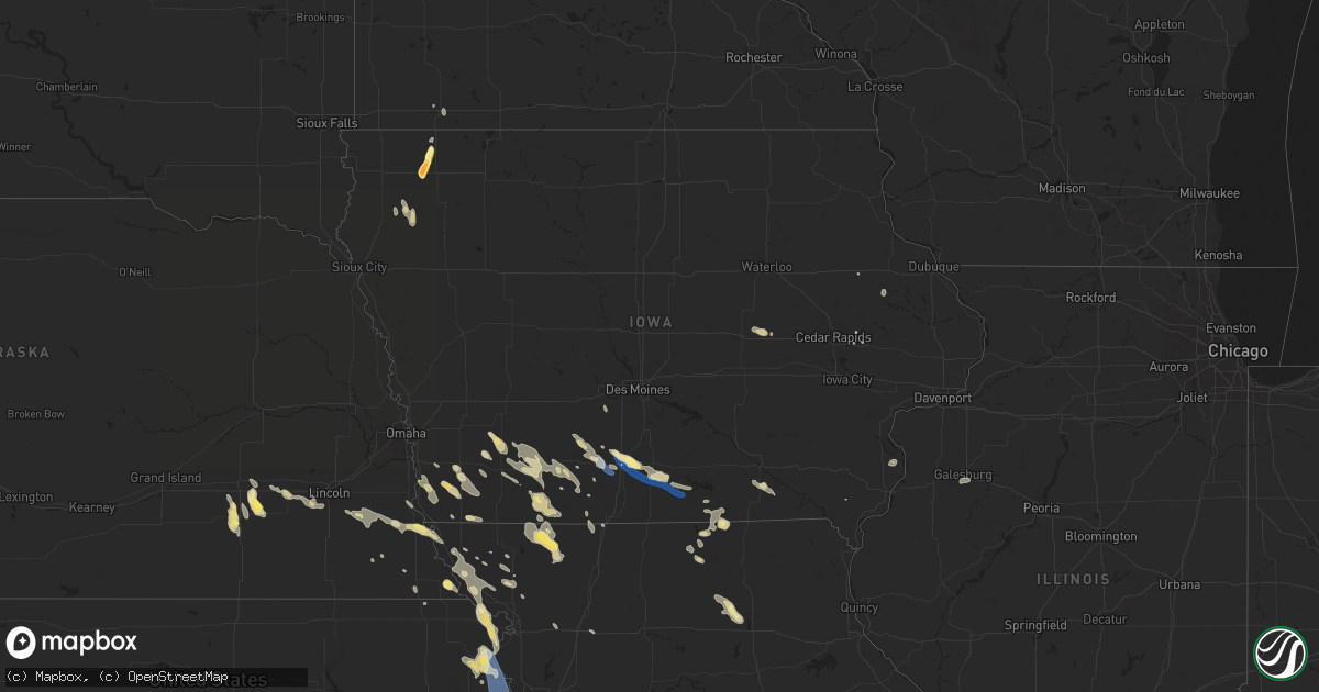
Hail Map in Iowa on July 10, 2024
Get this storm
July 10 map
$229
one time, instant access
Download today. No call, no setup
Keep the $229
Bought the map and want the full workflow? Apply the entire $229 to a subscription within 7 days. None of it is wasted.
Every map, not just this one
This buys you this map. Subscription and you get every map we run, in the markets you choose from a few cities to whole states to nationwide. Plus real-time alerts the moment a storm fires.
Contact data
Name, contact info, occupancy, even credit band for addresses in the footprint. You go from where it hit to who to call.
Become the source they trust
Unlimited branding weather history reports on demand. You already have the documented answer ready for the property owner, and you are the one who showed up with it.
Property data and RoofTrace estimates
Pull up any address you have got, its value and the exact code rules for that jurisdiction, straight from One Click Code. Then RoofTrace estimates the squares, pitch, and roof value, priced the way you price.
Storm reports in Iowa
Iowa
| Date | Description |
|---|---|
| 07/10/20245:24 PM CDT | Emergency management reported lots of hail the size of dimes and nickels with a few quarter sized hail stones mixed in. |
| 07/10/20243:42 PM CDT | Emergency management reported quarter sized hail in coburg. |
| 07/10/20243:01 PM CDT | A local report indicates 2.00 inch wind near 2 ENE Sheldon |
| 07/10/20242:59 PM CDT | Golf ball size hail along hwy 18 roughly 2 miles east of sheldon city center. Time estimated from radar. |
| 07/10/20242:50 PM CDT | No damage has been reported with this gust. |
| 07/10/20242:30 PM CDT | Mostly penny to nickel size but a few as large as quarter size. |
| 07/10/20242:22 PM CDT | Emergency management reported quarter sized hail. |
| 07/10/20241:35 PM CDT | Tower blown down at dispatch office in clarke county. Numerous trees in osceola of 14 to 16 diameter also damaged. Estimated winds of 60 to 70 mph. |
| 07/10/20241:30 PM CDT | Received a call estimating 40-50 mph winds... With 6-8 inch branches down around town. |
| 07/10/20241:19 PM CDT | Measured wind gust. Nearly an inch of rain in 30 minutes. 1 to 2 inch limbs broken off trees. |
All States Impacted by Hail Map on July 10, 2024
Cities Impacted by Hail Map on July 10, 2024
- Forestville, NY
- Irving, NY
- Perrysburg, NY
- Lawtons, NY
- North Collins, NY
- Eden, NY
- Hamburg, NY
- Orchard Park, NY
- Lake View, NY
- West Falls, NY
- Constableville, NY
- Lowville, NY
- Buffalo, NY
- Elma, NY
- Glenfield, NY
- Turin, NY
- Stewart, MN
- Castorland, NY
- Oswego, NY
- Orient, IA
- Greig, NY
- Brantingham, NY
- Lyons Falls, NY
- Macksburg, IA
- Lorimor, IA
- Pulaski, NY
- Peru, IA
- Murray, IA
- Afton, IA
- Springwater, NY
- Avon, NY
- Truro, IA
- Osceola, IA
- Penfield, NY
- Webster, NY
- Ontario, NY
- Fairport, NY
- Walworth, NY
- Macedon, NY
- Lima, NY
- Honeoye Falls, NY
- Williamson, NY
- Honeoye, NY
- Naples, NY
- Canandaigua, NY
- Redfield, NY
- Woodburn, IA
- New Virginia, IA
- Thayer, IA
- Franklin, MN
- Sodus, NY
- Griswold, IA
- Lewis, IA
- Morgan, MN
- Sacramento, NM
- Massena, IA
- Weldon, IA
- Humeston, IA
- Derby, IA
- Chariton, IA
- Corydon, IA
- Mescalero, NM
- Morton, MN
- Redwood Falls, MN
- Manchester, IA
- Lucas, IA
- Ellston, IA
- Ocheyedan, IA
- Sibley, IA
- Saint Michael, MN
- Bridgewater, IA
- Corning, IA
- Prescott, IA
- Savannah, NY
- Seneca Falls, NY
- Monticello, IA
- Hopkinton, IA
- Elliott, IA
- Creston, IA
- Cromwell, IA
- Cumberland, IA
- Villisca, IA
- Grant, IA
- Hanover, MN
- Millerton, IA
- Promise City, IA
- Russell, IA
- Ashton, IA
- Goliad, TX
- Red Oak, IA
- Plano, IA
- Shannon City, IA
- Lenox, IA
- Capitan, NM
- Lincoln, NM
- Weedsport, NY
- Port Byron, NY
- Montezuma, NY
- Nodaway, IA
- Gaines, PA
- Newcomb, NY
- Morris, PA
- Keene Valley, NY
- Lake Placid, NY
- Granville, IA
- Marcus, IA
- Sheldon, IA
- Sanborn, IA
- Remsen, IA
- Tingley, IA
- Ovid, NY
- Centerville, IA
- Mystic, IA
- Lakeville, NY
- Mathis, TX
- Skidmore, TX
- Diagonal, IA
- Jordan, NY
- Worthington, MN
- Brewster, MN
- Interlaken, NY
- Unionville, MO
- Archer, IA
- Mount Vernon, IA
- Kellerton, IA
- Wellsboro, PA
- Springville, IA
- Reading, MN
- Keene, NY
- Exline, IA
- Minneapolis, MN
- Mexico, NY
- Pollock, MO
- Cincinnati, IA
- Scipio Center, NY
- Genoa, NY
- Moravia, NY
- Mount Ayr, IA
- Clay, NY
- Liverpool, NY
- Baldwinsville, NY
- Livonia, MO
- Moulton, IA
- Hastings, IA
- Emerson, IA
- Lacona, NY
- Lisbon, IA
- Green City, MO
- Aurora, NY
- King Ferry, NY
- Geneseo, NY
- Alton, IA
- Lansing, NY
- Locke, NY
- Trumansburg, NY
- Imogene, IA
- Essex, IA
- Sharpsburg, IA
- Bedford, IA
- Bloomfield, IA
- Malvern, IA
- Glenwood, IA
- Milan, MO
- Ottumwa, IA
- Eagleville, MO
- Homer, NY
- Stanton, IA
- Toledo, IA
- Gravity, IA
- Hatfield, MO
- Melvin, IA
- Chelsea, IA
- Elberon, IA
- Clutier, IA
- Olmstedville, NY
- Minerva, NY
- Floris, IA
- Randolph, IA
- Le Mars, IA
- Tully, NY
- Skaneateles, NY
- Preble, NY
- Clearfield, IA
- Pottersville, NY
- Schroon Lake, NY
- North Creek, NY
- Bernhards Bay, NY
- Chestertown, NY
- Camden, NY
- Vining, IA
- Fabius, NY
- La Fayette, NY
- Blockton, IA
- Farragut, IA
- Shenandoah, IA
- Groton, NY
- Freeville, NY
- Adirondack, NY
- Paradox, NY
- New Boston, MO
- Cortland, NY
- Northboro, IA
- Ethel, MO
- Elmer, MO
- Redding, IA
- Manlius, NY
- Apulia Station, NY
- Crown Point, NY
- Truxton, NY
- McGraw, NY
- Ticonderoga, NY
- Waco, NE
- Coin, IA
- Blanchard, IA
- Forestport, NY
- Parnell, MO
- Sheridan, MO
- Cincinnatus, NY
- York, NE
- Hopkins, MO
- Bridport, VT
- Worth, MO
- Gentry, MO
- Bevier, MO
- Callao, MO
- Prescott, AZ
- North Hudson, NY
- Grant City, MO
- Pacific Junction, IA
- Yarnell, AZ
- Utica, NE
- Thurman, IA
- Exeter, NE
- McCool Junction, NE
- Kirkland, AZ
- Albany, MO
- Beaver Crossing, NE
- Seward, NE
- Goehner, NE
- West Point, IA
- Corona, NM
- Stanberry, MO
- Tabor, IA
- Sidney, IA
- Laredo, TX
- Milford, NE
- Carrizozo, NM
- Nebraska City, NE
- Moriah, NY
- Port Henry, NY
- Plattsmouth, NE
- Denton, NE
- Lincoln, NE
- Rock Port, MO
- Fairfax, MO
- Pleasant Dale, NE
- Canyon, TX
- Palm City, FL
- Port Saint Lucie, FL
- Moriah Center, NY
- Hamburg, IA
- Rowley, IA
- Independence, IA
- Friend, NE
- Brackettville, TX
- Roca, NE
- Cleveland, NY
- Walton, NE
- Martell, NE
- Skidmore, MO
- Benson, AZ
- Palmyra, NE
- Douglas, NE
- Fairmont, NE
- Galesburg, IL
- Bennet, NE
- Henderson, NE
- Mediapolis, IA
- Craig, MO
- Mound City, MO
- Maryville, MO
- Burr, NE
- Adams, NE
- Oakville, IA
- Grafton, NE
- Tecumseh, NE
- Waukee, IA
- Dallas Center, IA
- Adel, IA
- Van Meter, IA
- Geneva, NE
- Falls City, NE
- Unadilla, NE
- Derry, NM
- Las Cruces, NM
- Elk Creek, NE
- Rulo, NE
- Forest City, MO
- Humboldt, NE
- Dunbar, NE
- Talmage, NE
- Syracuse, NE
- Graham, MO
- Bolckow, MO
- White Cloud, KS
- Oregon, MO
- Barnard, MO
- Rosendale, MO
- Savannah, MO
- Highland, KS
- Brock, NE
- Troy, KS
- Peru, NE
- Rea, MO
- Ithaca, NY
- Dawson, NE
- Wathena, KS
- Julian, NE
- Otis, KS
- Sabetha, KS
- Watson, MO
- Atchison, KS
- Rushville, MO
- Muleshoe, TX
- Cummings, KS
- Lancaster, KS
- Effingham, KS
- Hoisington, KS
- Nortonville, KS
- Osborn, MO
- Stewartsville, MO
- Leavenworth, KS
- Easton, KS
- Maitland, MO
- Weston, MO
- Fort Leavenworth, KS
- Lansing, KS
- McLouth, KS
- Basehor, KS
- Tonganoxie, KS
- Kansas City, KS
- Bonner Springs, KS
- Shawnee, KS
- Amado, AZ
- Winchester, KS
- Arivaca, AZ
- Friona, TX
- Hamilton, MO
- Kidder, MO
- Winterset, IA
- Riverton, IA
- De Soto, IA
- Keystone, IA
- De Ruyter, NY
- Lodi, NY
- Hector, NY
- Sodus Point, NY
- Gypsum, KS
- Assaria, KS
- Peabody, KS
- New Russia, NY
- Martelle, IA
- West Branch, IA
- Coralville, IA
- Iowa City, IA
- Coatsville, MO
- Worthington, IA
- Delhi, IA


