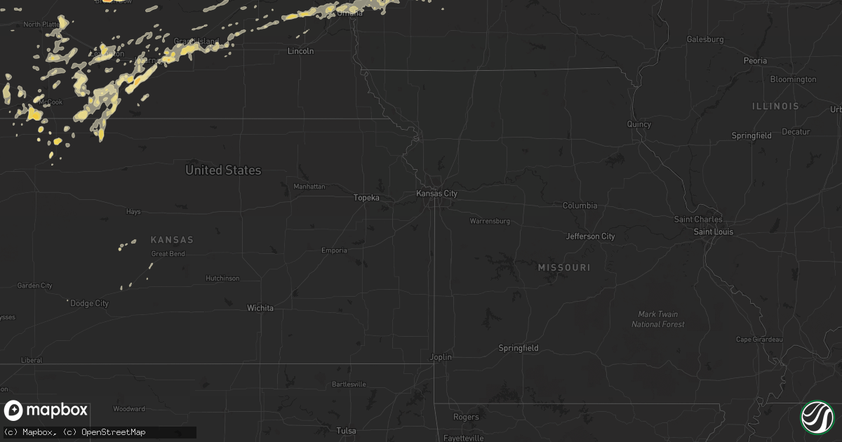
Hail Map in Nebraska on July 10, 2011
Get this storm
July 10 map
$229
one time, instant access
Download today. No call, no setup
Keep the $229
Bought the map and want the full workflow? Apply the entire $229 to a subscription within 7 days. None of it is wasted.
Every map, not just this one
This buys you this map. Subscription and you get every map we run, in the markets you choose from a few cities to whole states to nationwide. Plus real-time alerts the moment a storm fires.
Contact data
Name, contact info, occupancy, even credit band for addresses in the footprint. You go from where it hit to who to call.
Become the source they trust
Unlimited branding weather history reports on demand. You already have the documented answer ready for the property owner, and you are the one who showed up with it.
Property data and RoofTrace estimates
Pull up any address you have got, its value and the exact code rules for that jurisdiction, straight from One Click Code. Then RoofTrace estimates the squares, pitch, and roof value, priced the way you price.
Storm reports in Nebraska
Nebraska
| Date | Description |
|---|---|
| 07/10/20111:09 AM CDT | Measured thunderstorm gust by home wind equipment on roof. Scattered tree damage with some power outages...mainly on north side of town. |
| 07/10/201112:55 AM CDT | Power outages in newcastle |
| 07/10/201112:32 AM CDT | A local report indicates 60 MPH wind near 2 SW PENDER |
| 07/10/201112:24 AM CDT | A local report indicates 60 MPH wind near WAYNE |
| 07/10/201112:20 AM CDT | Law enforcement reported wind caused structual and tree damage on the west side of oneill to include downed trees 8 inches in diameter and blown out windows. |
| 07/10/201112:15 AM CDT | A local report indicates 60 MPH wind near 2 W ONEILL |
| 07/10/201112:13 AM CDT | A local report indicates 1.00 inch wind near DAVID CITY |
| 07/10/201112:13 AM CDT | A local report indicates 59 MPH wind near NORFOLK |
| 07/10/201112:05 AM CDT | Numerous tree limbs downed...some eight inches in diameter...power out. |
| 07/10/201112:05 AM CDT | Sustained for 1.5 minutes. Widespread power outages throughout the county. Estimated 3000 to 4000 people without power. |
| 07/10/201112:01 AM CDT | A local report indicates 60 MPH wind near 2 NW DAVID CITY |
| 07/09/201111:56 PM CDT | A local report indicates 68 MPH wind near NORFOLK |
| 07/09/201111:36 PM CDT | Numerous trees down...some vehicle damage...damage reports were from 1136 to 1146 pm. |
| 07/09/201111:22 PM CDT | Difficult to keep car on the road |
| 07/09/201111:20 PM CDT | Estimated 50 to 60 mile per hour winds just south of fullerton |
| 07/09/201111:16 PM CDT | Elba is without power. |
| 07/09/201111:03 PM CDT | Numerous reports of trees down in palmer |
| 07/09/201111:02 PM CDT | Quarter size hail lasted 2 minutes with 40 mile per hour winds. |
| 07/09/201111:00 PM CDT | A local report indicates 80 MPH wind near NORTH LOUP |
| 07/09/201110:50 PM CDT | Roof blown off of a shed and knocked a wall down as well. |
| 07/09/201110:43 PM CDT | Estimated 65 mile per hour winds with penny size hail. Some tree branches and power lines down as well. |
| 07/09/201110:43 PM CDT | A local report indicates 64 MPH wind near GRAND ISLAND AIRPORT |
| 07/09/201110:39 PM CDT | 60 mile per hour winds for the past 10 minute on the corner of wildwood and highway 281. |
| 07/09/201110:30 PM CDT | A utility pole was knocked down near 8th and 3rd streets and a large tree was blown over at 31st and e street. Power was knocked out in ravenna. |
| 07/09/201110:20 PM CDT | A local report indicates 60 MPH wind near 4 W GRAND ISLAND |
| 07/09/201110:10 PM CDT | Farmer reported some green snap damage to his corn crop and basketball hoop blown over as thunderstorms passed over his location. Report delayed from evening of july 10 |
| 07/09/201110:10 PM CDT | Farmer reported some green snap damage to his corn crop and basketball hoop blown over as thunderstorms passed over his location. Report delayed from evening of july 10 |
| 07/09/20119:55 PM CDT | A local report indicates 68 MPH wind near KEARNEY |
| 07/09/20119:48 PM CDT | A local report indicates 70 MPH wind near KEARNEY |
| 07/09/20119:45 PM CDT | A local report indicates 1.00 inch wind near LEXINGTON |
| 07/09/20119:42 PM CDT | 60 mile per hour wind in axtell with dime size hail. |
| 07/09/20119:42 PM CDT | A local report indicates 60 MPH wind near 7 SW GOTHENBURG |
| 07/09/20119:37 PM CDT | Trailer house was blown over on the west edge of holdrege. Mulitple power outages across holdredge and tree limbs with a diameter up to 2 to 6 inches blown down. |
| 07/09/20119:37 PM CDT | A local report indicates 60 MPH wind near 10 WSW HAYES CENTER |
| 07/09/20119:37 PM CDT | Trailer house was blown over on the west edge of holdrege. Mulitple power outages across holdredge and tree limbs with a diameter up to 2 to 6 inches blown down. |
| 07/09/20119:33 PM CDT | A local report indicates 1.00 inch wind near 9 E WELLFLEET |
| 07/09/20119:30 PM CDT | A local report indicates 60 MPH wind near 9 E WELLFLEET |
| 07/09/20119:30 PM CDT | A local report indicates 1.50 inch wind near 5 SE HOLDREGE |
| 07/09/20119:29 PM CDT | 60 mile per hour winds northwest of holdrege and nickel size hail. |
| 07/09/20119:28 PM CDT | A local report indicates 70 MPH wind near 2 E FARNAM |
| 07/09/20119:26 PM CDT | Power lines down in holdrege. |
| 07/09/20119:16 PM CDT | A local report indicates 70 MPH wind near 7 SW HAYES CENTER |
| 07/09/20119:16 PM CDT | A local report indicates 1.25 inch wind near BROKEN BOW |
| 07/09/20119:05 PM CDT | A local report indicates 2.00 inch wind near 1 NW BROKEN BOW |
| 07/09/20119:05 PM CDT | Said there was tree damage with spiked hailstones the size of tennis balls. |
| 07/09/20119:05 PM CDT | A local report indicates 1.00 inch wind near 2 S OXFORD |
| 07/09/20119:05 PM CDT | Delayed report from evening of july 10th. Southwest public power substation at hayes center recorded a wind gust to 71 mph on automated davis weather station. |
| 07/09/20118:57 PM CDT | A local report indicates 60 MPH wind near 14 SE STOCKVILLE |
| 07/09/20118:50 PM CDT | A local report indicates 1.50 inch wind near 9 NNE CALLAWAY |
| 07/09/20118:48 PM CDT | A local report indicates 60 MPH wind near 1 W EDISON |
| 07/09/20118:45 PM CDT | A few shingles blown off roof of house. |
| 07/09/20118:45 PM CDT | A local report indicates 60 MPH wind near BENKELMAN |
| 07/09/20118:39 PM CDT | A local report indicates 59 MPH wind near BENKELMAN |
| 07/09/20118:28 PM CDT | A local report indicates 1.50 inch wind near 8 NE ARNOLD |
| 07/09/20118:28 PM CDT | Local law enforcement reported 2 to 3 large cottonwood trees were blown down in and just west of edison. A 20 to 30 foot long tree limb that is 8 to 10 inches in diamet |
| 07/09/20118:20 PM CDT | 7 to 8 inch diameter green tree limbs broken off. |
| 07/09/20118:15 PM CDT | A local report indicates 1.75 inch wind near 3 NNW ARNOLD |
| 07/09/20118:15 PM CDT | A local report indicates 60 MPH wind near 3 NNW ARNOLD |
| 07/09/20117:52 PM CDT | 6 inch diameter tree branches were snapped off his elm tree. |
| 07/09/20117:26 PM CDT | A local report indicates 1.00 inch wind near 9 N TRYON |
All States Impacted by Hail Map on July 10, 2011
Cities Impacted by Hail Map on July 10, 2011
- Floresville, TX
- Argyle, WI
- Blanchardville, WI
- Valley, NE
- Weston, NE
- Brainard, NE
- Gretna, NE
- Colon, NE
- Waterloo, NE
- Malmo, NE
- Wahoo, NE
- Ashland, NE
- Mead, NE
- Bennington, NE
- Fremont, NE
- Omaha, NE
- Prague, NE
- Elkhorn, NE
- Yutan, NE
- Pueblo, CO
- McDonald, KS
- Register, GA
- Arthur, NE
- Hankinson, ND
- Wahpeton, ND
- Ellendale, ND
- Forbes, ND
- Broken Bow, NE
- Merna, NE
- Ewing, NE
- Hyannis, NE
- De Soto, WI
- Wilsonville, NE
- Sully, IA
- Glen Ullin, ND
- New Leipzig, ND
- Almont, ND
- Trenton, NE
- Culbertson, NE
- Herndon, KS
- Watertown, WI
- Juneau, WI
- Lowell, WI
- Beaver Dam, WI
- Reeseville, WI
- Statesboro, GA
- Hanover, IL
- Elizabeth, IL
- Glenwood, MN
- Atwood, KS
- Sutherland, NE
- Juda, WI
- Brodhead, WI
- Archer, IA
- Primghar, IA
- Stapleton, NE
- Chassell, MI
- Lake Linden, MI
- Mandan, ND
- Saint Anthony, ND
- Bismarck, ND
- Palisade, NE
- Hancock, IA
- Montevideo, MN
- Sacred Heart, MN
- Maynard, MN
- Granite Falls, MN
- Brady, NE
- Genoa, CO
- Bellingham, MN
- Gibbon, NE
- Shelton, NE
- Oakland, IA
- Minden, IA
- Logandale, NV
- Wentworth, SD
- Strasburg, ND
- Fort Yates, ND
- Richardton, ND
- Elgin, ND
- Bennett, CO
- Kiowa, CO
- Warren, IL
- Gratiot, WI
- Miller, NE
- Fairmount, ND
- Cyrus, MN
- Starbuck, MN
- Hospers, IA
- Paxton, NE
- Agate, CO
- Elizabeth, CO
- Littlefield, AZ
- Pflugerville, TX
- Shullsburg, WI
- Darlington, WI
- Madison, MN
- Marietta, MN
- Dickinson, ND
- Mound City, SD
- Eureka, SD
- Larned, KS
- Leola, SD
- Holbrook, NE
- Arapahoe, NE
- Black Canyon City, AZ
- Baldwin, IA
- Waterloo, WI
- Columbus, WI
- New Salem, ND
- Mott, ND
- Ashley, ND
- Jackson, MN
- Lakefield, MN
- Grinnell, IA
- Tama, IA
- Temple, GA
- Buchanan, GA
- Holmen, WI
- Selfridge, ND
- Kintyre, ND
- Napoleon, ND
- Braddock, ND
- Fennimore, WI
- Lancaster, WI
- Osceola, NE
- Columbus, NE
- Silver Creek, NE
- State Center, IA
- Carson, ND
- Maxwell, NE
- Regent, ND
- Kulm, ND
- Lehr, ND
- Fredonia, ND
- Eustis, NE
- Cambridge, NE
- Boone, IA
- Ogden, IA
- Madrid, IA
- Hecla, SD
- La Crosse, WI
- Cashton, WI
- Ontario, WI
- Scranton, IA
- Jefferson, IA
- Amherst, NE
- Pleasanton, NE
- Hazard, NE
- Lefor, ND
- Gladstone, ND
- Hebron, ND
- Flasher, ND
- Taylor, ND
- Linton, ND
- Menoken, ND
- Dawson, ND
- Hazelton, ND
- Moffit, ND
- Tappen, ND
- Oxford, NE
- Stamford, NE
- Berlin, ND
- Blue Earth, MN
- Granada, MN
- Fairmont, MN
- Cogswell, ND
- Forman, ND
- Chaseburg, WI
- Templeton, IA
- Manning, IA
- Audubon, IA
- Stuart, NE
- Atkinson, NE
- Ravenna, NE
- Enterprise, AL
- Elba, AL
- New Brockton, AL
- Elk River, MN
- Hokah, MN
- Caliente, NV
- Anselmo, NE
- Arnold, NE
- Lidgerwood, ND
- Plymouth, WI
- Minburn, IA
- Fowler, CO
- Olney Springs, CO
- Florence, SD
- Jackson, WI
- Davis, IL
- Durand, IL
- Alexander, KS
- Lismore, MN
- Norton, KS
- Henning, MN
- Phillips, NE
- Alda, NE
- Wood River, NE
- Grand Island, NE
- Doniphan, NE
- Baraboo, WI
- Reedsburg, WI
- Villard, MN
- Alexandria, MN
- Saint Francis, KS
- Brooten, MN
- Sunburg, MN
- New London, MN
- Belgrade, MN
- Dawson, MN
- Revillo, SD
- Labolt, SD
- New Era, MI
- Shelby, MI
- Lenora, KS
- Terril, IA
- Java, SD
- Hosmer, SD
- Campbell, MN
- Runnells, IA
- Pleasant Hill, IA
- Palo, IA
- Dallas Center, IA
- Grimes, IA
- Bouton, IA
- Perry, IA
- Woodward, IA
- Polk City, IA
- Granger, IA
- Marion, AL
- Centreville, AL
- Lawley, AL
- Wakpala, SD
- Mobridge, SD
- Trail City, SD
- Malta, ID
- Elwood, NE
- Lexington, NE
- Norwalk, IA
- Cumming, IA
- Elbow Lake, MN
- Wendell, MN
- Garrison, IA
- Dysart, IA
- La Porte City, IA
- Vinton, IA
- Mount Auburn, IA
- Clutier, IA
- Winter, WI
- Rupert, GA
- Collins, GA
- Henderson, NE
- Callaway, NE
- Masonville, IA
- Walker, IA
- Urbana, IA
- Brandon, IA
- Center Point, IA
- Rowley, IA
- Coggon, IA
- Winthrop, IA
- Traer, IA
- Stoddard, WI
- Hugo, CO
- Cimarron, KS
- Camden, AL
- Mequon, WI
- Milwaukee, WI
- Bagley, IA
- Rippey, IA
- Grand Junction, IA
- Coon Valley, WI
- Edgeley, ND
- Mears, MI
- Hesperia, MI
- Hart, MI
- Woodstock, MN
- Lake Wilson, MN
- Fullerton, ND
- Bowdle, SD
- Frederick, SD
- Crofton, NE
- Bloomfield, NE
- Niobrara, NE
- Springfield, SD
- Wallingford, IA
- Estherville, IA
- Ansley, NE
- Whitehall, MI
- Muskegon, MI
- Twin Lake, MI
- Fremont, MI
- Holton, MI
- Rothbury, MI
- Coon Rapids, IA
- Reynolds, GA
- Butler, GA
- Flagler, CO
- Polk, NE
- Benedict, NE
- Hampton, NE
- Bradshaw, NE
- Tallapoosa, GA
- Fullerton, NE
- Genoa, NE
- Round Lake, MN
- Worthington, MN
- Kenesaw, NE
- Northport, AL
- Victor, IA
- Raymond, NE
- Davey, NE
- Glidden, IA
- Wilmot, SD
- Hartwick, IA
- Deforest, WI
- Rio, WI
- Arlington, WI
- Litchfield, NE
- Randolph, AL
- Westfield, IA
- Marshalltown, IA
- Swea City, IA
- Elmore, MN
- Aurora, NE
- Giltner, NE
- Lost Nation, IA
- Pipestone, MN
- Cozad, NE
- Avoca, IA
- Kearney, NE
- Sisseton, SD
- Peever, SD
- Adrian, MN
- Ellsworth, MN
- Stanton, AL
- Bangor, MI
- Alberta, AL
- Oberlin, KS
- Anoka, MN
- Whitman, NE
- Nordheim, TX
- Hartington, NE
- Florala, AL
- Adair, IA
- New London, WI
- Oakes, ND
- Monroe, WI
- Monticello, WI
- Browntown, WI
- Selden, KS
- Arriba, CO
- Gwinner, ND
- Stirum, ND
- Wellfleet, NE
- Curtis, NE
- Maywood, NE
- West Salem, WI
- Onalaska, WI
- Tryon, NE
- Montague, MI
- Farwell, MN
- Toledo, IA
- Nevada, IA
- Ames, IA
- Egan, SD
- Trent, SD
- Flandreau, SD
- Elbert, CO
- Naponee, NE
- Wilcox, NE
- Prairie City, IA
- Stratford, SD
- Groton, SD
- Okabena, MN
- Ridott, IL
- Pecatonica, IL
- Rock City, IL
- Loomis, NE
- Atlanta, NE
- Holdrege, NE
- Searsboro, IA
- Lynnville, IA
- Reasnor, IA
- Pella, IA
- New Sharon, IA
- Dakota, MN
- Winona, MN
- Shellman, GA
- Potosi, WI
- Colfax, IA
- Axtell, NE
- Minden, NE
- Funk, NE
- Edison, NE
- Stevens Point, WI
- Panora, IA
- Guthrie Center, IA
- Yale, IA
- Lyndon Station, WI
- Rock Springs, WI
- Poynette, WI
- Lodi, WI
- La Valle, WI
- Merrimac, WI
- North Freedom, WI
- Overton, NE
- Lisbon, ND
- Montrose, CO
- Maxwell, IA
- Olin, IA
- Clarence, IA
- Oxford Junction, IA
- Mechanicsville, IA
- Wheatland, IA
- Stanwood, IA
- Lowden, IA
- Stratton, NE
- Wauneta, NE
- Benkelman, NE
- Spirit Lake, IA
- Milford, IA
- North Platte, NE
- Moorefield, NE
- Stromsburg, NE
- Guttenberg, IA
- Holy Cross, IA
- Orlando, FL
- D Hanis, TX
- Shelby, NE
- Loup City, NE
- Mitchellville, IA
- Johnstown, NE
- Green Valley, AZ
- Soldiers Grove, WI
- Larchwood, IA
- Dyersville, IA
- Worthington, IA
- Earlville, IA
- Carroll, IA
- Arcadia, IA
- Chipley, FL
- Bonifay, FL
- Lebanon, NE
- Weyauwega, WI
- Wiota, IA
- Anita, IA
- Tucson, AZ
- Kingsland, GA
- Hilliard, FL
- Folkston, GA
- White Oak, GA
- Sherrill, IA
- Colo, IA
- Arlington, CO
- Cambridge, IA
- Williamsburg, IA
- Oxford, IA
- Pollock, SD
- Britton, SD
- Malcom, IA
- Montezuma, IA
- Sumner, NE
- Ipswich, SD
- San Antonio, TX
- Muscadine, AL
- Ironwood, MI
- Wishek, ND
- Bertrand, NE
- Beaver City, NE
- Kinston, AL
- Arnolds Park, IA
- Okoboji, IA
- Tohatchi, NM
- Bird City, KS
- Stratford, IA
- Stanhope, IA
- Marion, IA
- Springville, IA
- Lyons, GA
- Zeeland, ND
- Elkhart Lake, WI
- Barnes City, IA
- Fort Ransom, ND
- Richland Center, WI
- Timewell, IL
- Camden, IL
- Pardeeville, WI
- Portage, WI
- Webster, SD
- Lawrence, MI
- Paw Paw, MI
- Hartford, MI
- Shellsburg, IA
- Fall River, WI
- Randolph, WI
- Mount Hope, WI
- Sahuarita, AZ
- Pennock, MN
- Akron, IA
- Elk Point, SD
- Le Mars, IA
- Marengo, IA
- South Amana, IA
- Maquoketa, IA
- Verona, ND
- Lamoure, ND
- Eden, SD
- Ramer, AL
- McCook, NE
- Hague, ND
- Fargo, GA
- Du Pont, GA
- Statenville, GA
- Monroe, NE
- Hastings, NE
- Wyoming, IA
- Blue River, WI
- Bangor, WI
- Hillpoint, WI
- Lone Rock, WI
- Grant, MI
- Montour, IA
- Mount Sterling, IL
- Colesburg, IA
- New Vienna, IA
- Holland, MN
- Ruthton, MN
- Dickey, ND
- Overton, NV
- Eufaula, AL
- Midway, AL
- Maple Lake, MN
- Annandale, MN
- La Crescent, MN
- Graettinger, IA
- Carson, IA
- Council Bluffs, IA
- Walnut, IA
- Underwood, IA
- Neola, IA
- McClelland, IA
- Crescent, IA
- Carter Lake, IA
- Treynor, IA
- Honey Creek, IA
- Lewis, IA
- Barrett, MN
- Moose Lake, MN
- Kettle River, MN
- Cedar Rapids, IA
- Toddville, IA
- Hiawatha, IA
- Robins, IA
- Elk Horn, IA
- Marne, IA
- Atlantic, IA
- Brayton, IA
- Shelby, IA
- Garretson, SD
- Jasper, MN
- Galena, IL
- Hazel Green, WI
- East Dubuque, IL
- Casey, IA
- Fountain City, WI
- Lowry, MN
- Ulysses, NE
- Hartland, WI
- Colgate, WI
- Houston, MN
- Malad City, ID
- Morris, MN
- Central City, IA
- Wausa, NE
- Kinsley, KS
- Offerle, KS
- Marion Junction, AL
- Orrville, AL
- Ledyard, IA
- Montgomery, AL
- Brantley, AL
- Anamosa, IA
- Clayton, AL
- Monticello, MN
- Big Lake, MN
- West Bend, WI
- Clearwater, NE
- Gays Mills, WI
- Sparta, WI
- Black River Falls, WI
- Gladbrook, IA
- Clear Lake, MN
- Ladora, IA
- Gilman, IA
- Kellogg, IA
- Renville, MN
- Nekoma, KS
- Danube, MN
- Olivia, MN
- Charlotte, IA
- Goose Lake, IA
- De Witt, IA
- Barney, ND
- Comstock, NE
- Westerville, NE
- Arcadia, NE
- Bellevue, IA
- Farley, IA
- Hopkinton, IA
- Deer Trail, CO
- Ramah, CO
- Gackle, ND
- Streeter, ND
- Punta Gorda, FL
- Pawnee Rock, KS
- Elm Creek, NE
- Rising City, NE
- David City, NE
- Viroqua, WI
- Genoa, WI
- Caledonia, MN
- Hartford, WI
- Oconomowoc, WI
- Lebanon, WI
- Ixonia, WI
- Rubicon, WI
- Ashippun, WI
- Neosho, WI
- Ravenna, MI
- Tuscaloosa, AL
- Palmer, NE
- Safford, AL
- Hordville, NE
- Nogales, AZ
- Rutland, ND
- Heron Lake, MN
- Hortense, GA
- Dixon, IL
- Rockland, WI
- Vona, CO
- Mantador, ND
- Orleans, NE
- Alma, NE
- Hayes Center, NE
- La Crosse, KS
- Magnet, NE
- Mclean, NE
- Randolph, NE
- Wyndmere, ND
- Coleridge, NE
- Lake Benton, MN
- Dresden, KS
- Jennings, KS
- Coalville, UT
- Guernsey, IA
- Monroe, IA
- Simla, CO
- White Cloud, MI
- Walkerville, MI
- Newaygo, MI
- Orangeville, IL
- Tanner, AL
- Windom, MN
- Huxley, IA
- Clemons, IA
- Saint Anthony, IA
- Melbourne, IA
- McCallsburg, IA
- Roland, IA
- Collins, IA
- Story City, IA
- Zearing, IA
- Tony, WI
- Page, NE
- Menlo, IA
- Ringsted, IA
- Superior, IA
- Vining, MN
- Long Lake, SD
- Albany, WI
- Prentice, WI
- Brantwood, WI
- Norcatur, KS
- Republican City, NE
- Hildreth, NE
- Smithfield, NE
- Astoria, IL
- Rushville, IL
- Westby, WI
- Martelle, IA
- Mount Vernon, IA
- Dayton, MN
- Becker, MN
- Saint Michael, MN
- Buffalo, MN
- Albertville, MN
- Rogers, MN
- Slayton, MN
- Balaton, MN
- Castle Rock, CO
- Linden, IA
- Bartley, NE
- Farnam, NE
- Albion, NE
- Glen Haven, WI
- Cassville, WI
- Armstrong, IA
- Norwalk, WI
- Stockholm, SD
- Shields, ND
- Sargent, NE
- Limon, CO
- Clarkfield, MN
- Saint Helena, NE
- Fordyce, NE
- Columbia, SD
- Houghton, SD
- Surprise, NE
- Laurel, NE
- Grenville, SD
- Tampico, IL
- Riverdale, NE
- Garfield, MN
- Fond Du Lac, WI
- Eden, WI
- Fort Dodge, IA
- Veblen, SD
- Chandler, MN
- Platteville, WI
- Warrens, WI
- Cobbtown, GA
- Metter, GA
- Wonewoc, WI
- Elroy, WI
- Fort Gaines, GA
- Abbeville, AL
- Chapman, NE
- Saint Libory, NE
- Donnelly, MN
- Hancock, MN
- Buckeye, AZ
- Newton, IA
- Sheboygan Falls, WI
- Keystone, NE
- Center, NE
- Verdigre, NE
- Hendley, NE
- Readstown, WI
- Lanark, IL
- Milnor, ND
- Galesville, WI
- Westport, SD
- Brunswick, GA
- Waverly, GA
- Waynesville, GA
- Ridgway, CO
- Waubay, SD
- Dalton, WI
- Dell Rapids, SD
- Colman, SD
- Monticello, IA
- Gresham, NE
- Ralston, IA
- Osmond, NE
- Stockville, NE
- Newcastle, NE
- Defuniak Springs, FL
- La Motte, IA
- Zwingle, IA
- Hawkinsville, GA
- Trempealeau, WI
- Brewster, MN
- South Shore, SD
- Watertown, SD
- Oostburg, WI
- Cedar Grove, WI
- Waldo, WI
- Winnetoon, NE
- Creighton, NE
- Junction City, WI
- Custer, WI
- Rosholt, WI
- Aberdeen, SD
- Quasqueton, IA
- Van Meter, IA
- Booneville, IA
- Waukee, IA
- West Des Moines, IA
- Sun Prairie, WI
- Marshall, WI
- Adell, WI
- Fredonia, WI
- Random Lake, WI
- Campbellsport, WI
- Cascade, WI
- Kewaskum, WI
- Savanna, IL
- Ainsworth, NE
- Selby, SD
- Carlisle, IA
- Des Moines, IA
- Indianola, IA
- Swan, IA
- Hartford, IA
- Pleasantville, IA
- Glenbeulah, WI
- Glenwood, AL
- Vesper, WI
- Titus, AL
- Cascade, IA
- Albany, IL
- Fruitport, MI
- Spring Lake, MI
- Ceresco, NE
- Cazenovia, WI
- Inman, NE
- Maplesville, AL
- Brooklyn, IA
- Chelsea, IA
- Hardwick, MN
- Luverne, MN
- Ryan, IA
- Odessa, NE
- Cedartown, GA
- Bayard, IA
- Edgerton, MN
- Lockney, TX
- Chippewa Falls, WI
- Sanderson, FL
- Brandon, MN
- Kensington, MN
- Tulare, SD
- Shorterville, AL
- Bruce, SD
- Toronto, SD
- Rocksprings, TX
- Ladysmith, WI
- Bruce, WI
- Sutherland, IA
- Paullina, IA
- Athens, AL
- Kenneth, MN
- Mentone, AL
- Medina, TX
- Hondo, TX
- Dickens, IA
- Spencer, IA
- Hershey, NE
- Cedar Rapids, NE
- Garwin, IA
- Barnard, SD
- Greenfield, IA
- Fontanelle, IA
- Burlington, CO
- Dedham, IA
- Mineral Point, WI
- Cuba City, WI
- Belmont, WI
- Goodland, KS
- Sheboygan, WI
- Dakota, IL
- Roscoe, SD
- Long Prairie, MN
- Spicer, MN
- Atwater, MN
- Iron Ridge, WI
- Horicon, WI
- Hustisford, WI
- Warner, SD
- Coker, AL
- Buhl, AL


