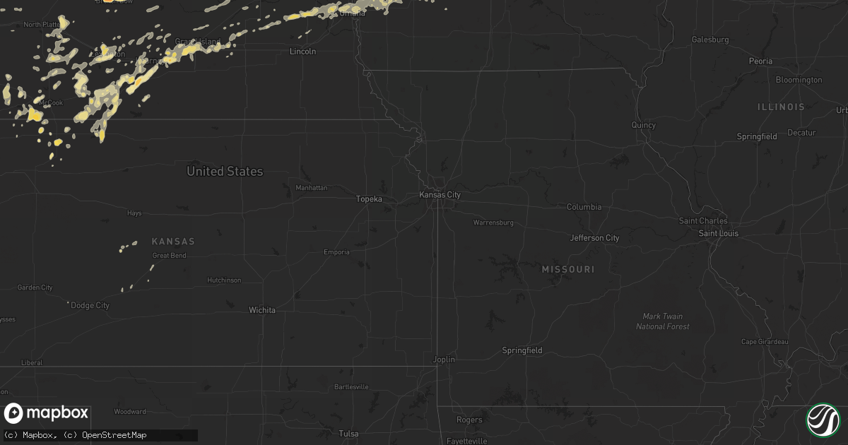
Hail Map in North Dakota on July 10, 2011
Get this storm
July 10 map
$229
one time, instant access
Download today. No call, no setup
Keep the $229
Bought the map and want the full workflow? Apply the entire $229 to a subscription within 7 days. None of it is wasted.
Every map, not just this one
This buys you this map. Subscription and you get every map we run, in the markets you choose from a few cities to whole states to nationwide. Plus real-time alerts the moment a storm fires.
Contact data
Name, contact info, occupancy, even credit band for addresses in the footprint. You go from where it hit to who to call.
Become the source they trust
Unlimited branding weather history reports on demand. You already have the documented answer ready for the property owner, and you are the one who showed up with it.
Property data and RoofTrace estimates
Pull up any address you have got, its value and the exact code rules for that jurisdiction, straight from One Click Code. Then RoofTrace estimates the squares, pitch, and roof value, priced the way you price.
Storm reports in North Dakota
North Dakota
| Date | Description |
|---|---|
| 07/10/20116:32 PM CDT | Trees down at farmstead...including tree leaning on house. Surrounding shelterbelts do not seem to have as much damage. |
| 07/10/20116:20 PM CDT | Grain bin damaged. |
| 07/10/20115:40 PM CDT | A local report indicates 60 MPH wind near LIDGERWOOD |
| 07/10/20115:38 PM CDT | Report of trees down in cayuga |
| 07/10/20115:30 PM CDT | Barn and four grain bins blown off their foundations. Pole barn lost its roof. Several trees uprooted and branches up to a foot in diameter snapped. Estimated wind gust |
| 07/10/20115:17 PM CDT | Trained spotter estimates 70 mph wind gust that has knocked over large tree branches |
| 07/10/20115:15 PM CDT | Roof on grain bin collapsed |
| 07/10/20115:10 PM CDT | Roof blown off machine shop. Time approximate. |
| 07/10/20115:06 PM CDT | Law enforcement estimates 60 mph wind gust |
| 07/10/20115:00 PM CDT | Some houses missing shingles off roof. Large trees down in town. |
| 07/10/20114:42 PM CDT | Numerous trees and branches down in and around ludden. |
| 07/10/20114:35 PM CDT | Oakes police department reports a tornado on the ground near oakes. |
| 07/10/20114:35 PM CDT | Roof damage to building and sheet metal missing. |
| 07/10/20114:31 PM CDT | Numerous tree branches down. Winds estimated up to 80 mph. |
| 07/10/20114:30 PM CDT | Grain bins blown over. |
| 07/10/20114:09 PM CDT | Shingles blown off roof. Winds estimated at least 60 mph. |
| 07/10/20114:04 PM CDT | Power lines down. |
| 07/10/20114:02 PM CDT | Winds estimated at 50 to 60 mph...pea size hail. |
| 07/10/20113:48 PM CDT | Delayed report. Damage assessment team surveyed damage at a farmstead 5 miles northwest of merricourt. Residents witnessed a tornado touchdown in a shelterbelt as they |
| 07/10/20113:40 PM CDT | Arb observer reported 70 to 80 miles per hour winds with grain bin blown down. 2.90 inches precipitation in 40 minutes and 3/4 inch hail. |
| 07/10/20113:34 PM CDT | Mcintosh county sheriff reported a tornado on the ground. Relayed by state radio. |
| 07/10/20112:57 PM CDT | A local report indicates 80 MPH wind near 1 SE BURNSTAD |
| 07/10/20112:45 PM CDT | Grain bin with estimated weight of 17 to 20 thousand pounds...10 tons...was lifted and rolled nearly three quarters of a mile from its original location to another farm |
| 07/10/20112:45 PM CDT | Trees uprooted...some as large as 4 feet in diameter and greater than 100 feet tall. |
| 07/10/20112:40 PM CDT | 18 thousand bushel grain bin moved 250 yds. Extensive tree damage with downed trees pointing in random directions. Trees 60 years old...100 ft tall. |
| 07/10/20112:40 PM CDT | Heavy rain. |
| 07/10/20112:40 PM CDT | Possible tornado. 1800 feet of shelter belt missing. Grain bin destroyed and thrown into tree in front yard. Nws damage survey will be conducted. |
| 07/10/20112:35 PM CDT | Empty grain bins damaged. Winds estimated at 85 mph. |
| 07/10/20112:33 PM CDT | A local report indicates 60 MPH wind near 2 E BRADDOCK |
| 07/10/20112:33 PM CDT | Also had 1 inch hail and heavy rain. |
| 07/10/20112:28 PM CDT | Extensive tree branch damage in hazelton. Three inch to six inch in diameter branches blown off of trees. Gas station on the west side of town had damage to the roof ov |
| 07/10/20112:24 PM CDT | Minor damage to farmstead. Shingles blown off of trailer home and small building blown over. Winds estimated at 70 mph. |
| 07/10/20112:20 PM CDT | Double poled wood transmission lines snapped in half. Heavy ranch sign with three foot concrete anchors ripped out of the ground. Camper flipped off of the highway and |
| 07/10/20112:15 PM CDT | Relayed by media. Measured with home anemometer. |
| 07/10/20112:14 PM CDT | Double power lines are snapped about 2 miles south of moffit road on 262nd st se. |
| 07/10/20111:53 PM CDT | Nickel to qaurter size hail. |
| 07/10/20111:52 PM CDT | Nws employee estimated 75 mph wind gusts and penny sized hail. |
| 07/10/20111:50 PM CDT | Lasted until 205 pm. Peak wind speeds around 40 mph. This is falconer estates subdivision. Several homes had roof and gutter damage. Leaves...small branches...and fruit |
| 07/10/20111:50 PM CDT | A local report indicates 1.75 inch wind near 9 S SHIELDS |
| 07/10/20111:45 PM CDT | 2 foot in diamater oak trees were uprooted near huff. Initial estimates of winds in excess of 75 mph. |
| 07/10/20111:43 PM CDT | Lasted 10 minutes |
| 07/10/201112:25 PM CDT | Strong winds lasted 15 minutes. Also pea sized hail. |
| 07/10/201112:02 PM CDT | Nickel to quarter size hail. |
| 07/10/201111:50 AM CDT | A local report indicates 1.75 inch wind near 5 SSE GLEN ULLIN |
| 07/10/201111:30 AM CDT | Mostly pea size hail with a few larger stones. No damage to report. Correction to earlier report. |
| 07/10/201111:30 AM CDT | A local report indicates 2.00 inch wind near 5 SSE GLEN ULLIN |
| 07/10/201111:15 AM CDT | Hail estimated at 2 inches based upon photo provided by media. |
| 07/09/20117:12 PM CDT | Person 5 s of sutton nd sees a tornado 10 miles to his east ... Relayed via wfo bismarck |
All States Impacted by Hail Map on July 10, 2011
Cities Impacted by Hail Map on July 10, 2011
- Floresville, TX
- Argyle, WI
- Blanchardville, WI
- Valley, NE
- Weston, NE
- Brainard, NE
- Gretna, NE
- Colon, NE
- Waterloo, NE
- Malmo, NE
- Wahoo, NE
- Ashland, NE
- Mead, NE
- Bennington, NE
- Fremont, NE
- Omaha, NE
- Prague, NE
- Elkhorn, NE
- Yutan, NE
- Pueblo, CO
- McDonald, KS
- Register, GA
- Arthur, NE
- Hankinson, ND
- Wahpeton, ND
- Ellendale, ND
- Forbes, ND
- Broken Bow, NE
- Merna, NE
- Ewing, NE
- Hyannis, NE
- De Soto, WI
- Wilsonville, NE
- Sully, IA
- Glen Ullin, ND
- New Leipzig, ND
- Almont, ND
- Trenton, NE
- Culbertson, NE
- Herndon, KS
- Watertown, WI
- Juneau, WI
- Lowell, WI
- Beaver Dam, WI
- Reeseville, WI
- Statesboro, GA
- Hanover, IL
- Elizabeth, IL
- Glenwood, MN
- Atwood, KS
- Sutherland, NE
- Juda, WI
- Brodhead, WI
- Archer, IA
- Primghar, IA
- Stapleton, NE
- Chassell, MI
- Lake Linden, MI
- Mandan, ND
- Saint Anthony, ND
- Bismarck, ND
- Palisade, NE
- Hancock, IA
- Montevideo, MN
- Sacred Heart, MN
- Maynard, MN
- Granite Falls, MN
- Brady, NE
- Genoa, CO
- Bellingham, MN
- Gibbon, NE
- Shelton, NE
- Oakland, IA
- Minden, IA
- Logandale, NV
- Wentworth, SD
- Strasburg, ND
- Fort Yates, ND
- Richardton, ND
- Elgin, ND
- Bennett, CO
- Kiowa, CO
- Warren, IL
- Gratiot, WI
- Miller, NE
- Fairmount, ND
- Cyrus, MN
- Starbuck, MN
- Hospers, IA
- Paxton, NE
- Agate, CO
- Elizabeth, CO
- Littlefield, AZ
- Pflugerville, TX
- Shullsburg, WI
- Darlington, WI
- Madison, MN
- Marietta, MN
- Dickinson, ND
- Mound City, SD
- Eureka, SD
- Larned, KS
- Leola, SD
- Holbrook, NE
- Arapahoe, NE
- Black Canyon City, AZ
- Baldwin, IA
- Waterloo, WI
- Columbus, WI
- New Salem, ND
- Mott, ND
- Ashley, ND
- Jackson, MN
- Lakefield, MN
- Grinnell, IA
- Tama, IA
- Temple, GA
- Buchanan, GA
- Holmen, WI
- Selfridge, ND
- Kintyre, ND
- Napoleon, ND
- Braddock, ND
- Fennimore, WI
- Lancaster, WI
- Osceola, NE
- Columbus, NE
- Silver Creek, NE
- State Center, IA
- Carson, ND
- Maxwell, NE
- Regent, ND
- Kulm, ND
- Lehr, ND
- Fredonia, ND
- Eustis, NE
- Cambridge, NE
- Boone, IA
- Ogden, IA
- Madrid, IA
- Hecla, SD
- La Crosse, WI
- Cashton, WI
- Ontario, WI
- Scranton, IA
- Jefferson, IA
- Amherst, NE
- Pleasanton, NE
- Hazard, NE
- Lefor, ND
- Gladstone, ND
- Hebron, ND
- Flasher, ND
- Taylor, ND
- Linton, ND
- Menoken, ND
- Dawson, ND
- Hazelton, ND
- Moffit, ND
- Tappen, ND
- Oxford, NE
- Stamford, NE
- Berlin, ND
- Blue Earth, MN
- Granada, MN
- Fairmont, MN
- Cogswell, ND
- Forman, ND
- Chaseburg, WI
- Templeton, IA
- Manning, IA
- Audubon, IA
- Stuart, NE
- Atkinson, NE
- Ravenna, NE
- Enterprise, AL
- Elba, AL
- New Brockton, AL
- Elk River, MN
- Hokah, MN
- Caliente, NV
- Anselmo, NE
- Arnold, NE
- Lidgerwood, ND
- Plymouth, WI
- Minburn, IA
- Fowler, CO
- Olney Springs, CO
- Florence, SD
- Jackson, WI
- Davis, IL
- Durand, IL
- Alexander, KS
- Lismore, MN
- Norton, KS
- Henning, MN
- Phillips, NE
- Alda, NE
- Wood River, NE
- Grand Island, NE
- Doniphan, NE
- Baraboo, WI
- Reedsburg, WI
- Villard, MN
- Alexandria, MN
- Saint Francis, KS
- Brooten, MN
- Sunburg, MN
- New London, MN
- Belgrade, MN
- Dawson, MN
- Revillo, SD
- Labolt, SD
- New Era, MI
- Shelby, MI
- Lenora, KS
- Terril, IA
- Java, SD
- Hosmer, SD
- Campbell, MN
- Runnells, IA
- Pleasant Hill, IA
- Palo, IA
- Dallas Center, IA
- Grimes, IA
- Bouton, IA
- Perry, IA
- Woodward, IA
- Polk City, IA
- Granger, IA
- Marion, AL
- Centreville, AL
- Lawley, AL
- Wakpala, SD
- Mobridge, SD
- Trail City, SD
- Malta, ID
- Elwood, NE
- Lexington, NE
- Norwalk, IA
- Cumming, IA
- Elbow Lake, MN
- Wendell, MN
- Garrison, IA
- Dysart, IA
- La Porte City, IA
- Vinton, IA
- Mount Auburn, IA
- Clutier, IA
- Winter, WI
- Rupert, GA
- Collins, GA
- Henderson, NE
- Callaway, NE
- Masonville, IA
- Walker, IA
- Urbana, IA
- Brandon, IA
- Center Point, IA
- Rowley, IA
- Coggon, IA
- Winthrop, IA
- Traer, IA
- Stoddard, WI
- Hugo, CO
- Cimarron, KS
- Camden, AL
- Mequon, WI
- Milwaukee, WI
- Bagley, IA
- Rippey, IA
- Grand Junction, IA
- Coon Valley, WI
- Edgeley, ND
- Mears, MI
- Hesperia, MI
- Hart, MI
- Woodstock, MN
- Lake Wilson, MN
- Fullerton, ND
- Bowdle, SD
- Frederick, SD
- Crofton, NE
- Bloomfield, NE
- Niobrara, NE
- Springfield, SD
- Wallingford, IA
- Estherville, IA
- Ansley, NE
- Whitehall, MI
- Muskegon, MI
- Twin Lake, MI
- Fremont, MI
- Holton, MI
- Rothbury, MI
- Coon Rapids, IA
- Reynolds, GA
- Butler, GA
- Flagler, CO
- Polk, NE
- Benedict, NE
- Hampton, NE
- Bradshaw, NE
- Tallapoosa, GA
- Fullerton, NE
- Genoa, NE
- Round Lake, MN
- Worthington, MN
- Kenesaw, NE
- Northport, AL
- Victor, IA
- Raymond, NE
- Davey, NE
- Glidden, IA
- Wilmot, SD
- Hartwick, IA
- Deforest, WI
- Rio, WI
- Arlington, WI
- Litchfield, NE
- Randolph, AL
- Westfield, IA
- Marshalltown, IA
- Swea City, IA
- Elmore, MN
- Aurora, NE
- Giltner, NE
- Lost Nation, IA
- Pipestone, MN
- Cozad, NE
- Avoca, IA
- Kearney, NE
- Sisseton, SD
- Peever, SD
- Adrian, MN
- Ellsworth, MN
- Stanton, AL
- Bangor, MI
- Alberta, AL
- Oberlin, KS
- Anoka, MN
- Whitman, NE
- Nordheim, TX
- Hartington, NE
- Florala, AL
- Adair, IA
- New London, WI
- Oakes, ND
- Monroe, WI
- Monticello, WI
- Browntown, WI
- Selden, KS
- Arriba, CO
- Gwinner, ND
- Stirum, ND
- Wellfleet, NE
- Curtis, NE
- Maywood, NE
- West Salem, WI
- Onalaska, WI
- Tryon, NE
- Montague, MI
- Farwell, MN
- Toledo, IA
- Nevada, IA
- Ames, IA
- Egan, SD
- Trent, SD
- Flandreau, SD
- Elbert, CO
- Naponee, NE
- Wilcox, NE
- Prairie City, IA
- Stratford, SD
- Groton, SD
- Okabena, MN
- Ridott, IL
- Pecatonica, IL
- Rock City, IL
- Loomis, NE
- Atlanta, NE
- Holdrege, NE
- Searsboro, IA
- Lynnville, IA
- Reasnor, IA
- Pella, IA
- New Sharon, IA
- Dakota, MN
- Winona, MN
- Shellman, GA
- Potosi, WI
- Colfax, IA
- Axtell, NE
- Minden, NE
- Funk, NE
- Edison, NE
- Stevens Point, WI
- Panora, IA
- Guthrie Center, IA
- Yale, IA
- Lyndon Station, WI
- Rock Springs, WI
- Poynette, WI
- Lodi, WI
- La Valle, WI
- Merrimac, WI
- North Freedom, WI
- Overton, NE
- Lisbon, ND
- Montrose, CO
- Maxwell, IA
- Olin, IA
- Clarence, IA
- Oxford Junction, IA
- Mechanicsville, IA
- Wheatland, IA
- Stanwood, IA
- Lowden, IA
- Stratton, NE
- Wauneta, NE
- Benkelman, NE
- Spirit Lake, IA
- Milford, IA
- North Platte, NE
- Moorefield, NE
- Stromsburg, NE
- Guttenberg, IA
- Holy Cross, IA
- Orlando, FL
- D Hanis, TX
- Shelby, NE
- Loup City, NE
- Mitchellville, IA
- Johnstown, NE
- Green Valley, AZ
- Soldiers Grove, WI
- Larchwood, IA
- Dyersville, IA
- Worthington, IA
- Earlville, IA
- Carroll, IA
- Arcadia, IA
- Chipley, FL
- Bonifay, FL
- Lebanon, NE
- Weyauwega, WI
- Wiota, IA
- Anita, IA
- Tucson, AZ
- Kingsland, GA
- Hilliard, FL
- Folkston, GA
- White Oak, GA
- Sherrill, IA
- Colo, IA
- Arlington, CO
- Cambridge, IA
- Williamsburg, IA
- Oxford, IA
- Pollock, SD
- Britton, SD
- Malcom, IA
- Montezuma, IA
- Sumner, NE
- Ipswich, SD
- San Antonio, TX
- Muscadine, AL
- Ironwood, MI
- Wishek, ND
- Bertrand, NE
- Beaver City, NE
- Kinston, AL
- Arnolds Park, IA
- Okoboji, IA
- Tohatchi, NM
- Bird City, KS
- Stratford, IA
- Stanhope, IA
- Marion, IA
- Springville, IA
- Lyons, GA
- Zeeland, ND
- Elkhart Lake, WI
- Barnes City, IA
- Fort Ransom, ND
- Richland Center, WI
- Timewell, IL
- Camden, IL
- Pardeeville, WI
- Portage, WI
- Webster, SD
- Lawrence, MI
- Paw Paw, MI
- Hartford, MI
- Shellsburg, IA
- Fall River, WI
- Randolph, WI
- Mount Hope, WI
- Sahuarita, AZ
- Pennock, MN
- Akron, IA
- Elk Point, SD
- Le Mars, IA
- Marengo, IA
- South Amana, IA
- Maquoketa, IA
- Verona, ND
- Lamoure, ND
- Eden, SD
- Ramer, AL
- McCook, NE
- Hague, ND
- Fargo, GA
- Du Pont, GA
- Statenville, GA
- Monroe, NE
- Hastings, NE
- Wyoming, IA
- Blue River, WI
- Bangor, WI
- Hillpoint, WI
- Lone Rock, WI
- Grant, MI
- Montour, IA
- Mount Sterling, IL
- Colesburg, IA
- New Vienna, IA
- Holland, MN
- Ruthton, MN
- Dickey, ND
- Overton, NV
- Eufaula, AL
- Midway, AL
- Maple Lake, MN
- Annandale, MN
- La Crescent, MN
- Graettinger, IA
- Carson, IA
- Council Bluffs, IA
- Walnut, IA
- Underwood, IA
- Neola, IA
- McClelland, IA
- Crescent, IA
- Carter Lake, IA
- Treynor, IA
- Honey Creek, IA
- Lewis, IA
- Barrett, MN
- Moose Lake, MN
- Kettle River, MN
- Cedar Rapids, IA
- Toddville, IA
- Hiawatha, IA
- Robins, IA
- Elk Horn, IA
- Marne, IA
- Atlantic, IA
- Brayton, IA
- Shelby, IA
- Garretson, SD
- Jasper, MN
- Galena, IL
- Hazel Green, WI
- East Dubuque, IL
- Casey, IA
- Fountain City, WI
- Lowry, MN
- Ulysses, NE
- Hartland, WI
- Colgate, WI
- Houston, MN
- Malad City, ID
- Morris, MN
- Central City, IA
- Wausa, NE
- Kinsley, KS
- Offerle, KS
- Marion Junction, AL
- Orrville, AL
- Ledyard, IA
- Montgomery, AL
- Brantley, AL
- Anamosa, IA
- Clayton, AL
- Monticello, MN
- Big Lake, MN
- West Bend, WI
- Clearwater, NE
- Gays Mills, WI
- Sparta, WI
- Black River Falls, WI
- Gladbrook, IA
- Clear Lake, MN
- Ladora, IA
- Gilman, IA
- Kellogg, IA
- Renville, MN
- Nekoma, KS
- Danube, MN
- Olivia, MN
- Charlotte, IA
- Goose Lake, IA
- De Witt, IA
- Barney, ND
- Comstock, NE
- Westerville, NE
- Arcadia, NE
- Bellevue, IA
- Farley, IA
- Hopkinton, IA
- Deer Trail, CO
- Ramah, CO
- Gackle, ND
- Streeter, ND
- Punta Gorda, FL
- Pawnee Rock, KS
- Elm Creek, NE
- Rising City, NE
- David City, NE
- Viroqua, WI
- Genoa, WI
- Caledonia, MN
- Hartford, WI
- Oconomowoc, WI
- Lebanon, WI
- Ixonia, WI
- Rubicon, WI
- Ashippun, WI
- Neosho, WI
- Ravenna, MI
- Tuscaloosa, AL
- Palmer, NE
- Safford, AL
- Hordville, NE
- Nogales, AZ
- Rutland, ND
- Heron Lake, MN
- Hortense, GA
- Dixon, IL
- Rockland, WI
- Vona, CO
- Mantador, ND
- Orleans, NE
- Alma, NE
- Hayes Center, NE
- La Crosse, KS
- Magnet, NE
- Mclean, NE
- Randolph, NE
- Wyndmere, ND
- Coleridge, NE
- Lake Benton, MN
- Dresden, KS
- Jennings, KS
- Coalville, UT
- Guernsey, IA
- Monroe, IA
- Simla, CO
- White Cloud, MI
- Walkerville, MI
- Newaygo, MI
- Orangeville, IL
- Tanner, AL
- Windom, MN
- Huxley, IA
- Clemons, IA
- Saint Anthony, IA
- Melbourne, IA
- McCallsburg, IA
- Roland, IA
- Collins, IA
- Story City, IA
- Zearing, IA
- Tony, WI
- Page, NE
- Menlo, IA
- Ringsted, IA
- Superior, IA
- Vining, MN
- Long Lake, SD
- Albany, WI
- Prentice, WI
- Brantwood, WI
- Norcatur, KS
- Republican City, NE
- Hildreth, NE
- Smithfield, NE
- Astoria, IL
- Rushville, IL
- Westby, WI
- Martelle, IA
- Mount Vernon, IA
- Dayton, MN
- Becker, MN
- Saint Michael, MN
- Buffalo, MN
- Albertville, MN
- Rogers, MN
- Slayton, MN
- Balaton, MN
- Castle Rock, CO
- Linden, IA
- Bartley, NE
- Farnam, NE
- Albion, NE
- Glen Haven, WI
- Cassville, WI
- Armstrong, IA
- Norwalk, WI
- Stockholm, SD
- Shields, ND
- Sargent, NE
- Limon, CO
- Clarkfield, MN
- Saint Helena, NE
- Fordyce, NE
- Columbia, SD
- Houghton, SD
- Surprise, NE
- Laurel, NE
- Grenville, SD
- Tampico, IL
- Riverdale, NE
- Garfield, MN
- Fond Du Lac, WI
- Eden, WI
- Fort Dodge, IA
- Veblen, SD
- Chandler, MN
- Platteville, WI
- Warrens, WI
- Cobbtown, GA
- Metter, GA
- Wonewoc, WI
- Elroy, WI
- Fort Gaines, GA
- Abbeville, AL
- Chapman, NE
- Saint Libory, NE
- Donnelly, MN
- Hancock, MN
- Buckeye, AZ
- Newton, IA
- Sheboygan Falls, WI
- Keystone, NE
- Center, NE
- Verdigre, NE
- Hendley, NE
- Readstown, WI
- Lanark, IL
- Milnor, ND
- Galesville, WI
- Westport, SD
- Brunswick, GA
- Waverly, GA
- Waynesville, GA
- Ridgway, CO
- Waubay, SD
- Dalton, WI
- Dell Rapids, SD
- Colman, SD
- Monticello, IA
- Gresham, NE
- Ralston, IA
- Osmond, NE
- Stockville, NE
- Newcastle, NE
- Defuniak Springs, FL
- La Motte, IA
- Zwingle, IA
- Hawkinsville, GA
- Trempealeau, WI
- Brewster, MN
- South Shore, SD
- Watertown, SD
- Oostburg, WI
- Cedar Grove, WI
- Waldo, WI
- Winnetoon, NE
- Creighton, NE
- Junction City, WI
- Custer, WI
- Rosholt, WI
- Aberdeen, SD
- Quasqueton, IA
- Van Meter, IA
- Booneville, IA
- Waukee, IA
- West Des Moines, IA
- Sun Prairie, WI
- Marshall, WI
- Adell, WI
- Fredonia, WI
- Random Lake, WI
- Campbellsport, WI
- Cascade, WI
- Kewaskum, WI
- Savanna, IL
- Ainsworth, NE
- Selby, SD
- Carlisle, IA
- Des Moines, IA
- Indianola, IA
- Swan, IA
- Hartford, IA
- Pleasantville, IA
- Glenbeulah, WI
- Glenwood, AL
- Vesper, WI
- Titus, AL
- Cascade, IA
- Albany, IL
- Fruitport, MI
- Spring Lake, MI
- Ceresco, NE
- Cazenovia, WI
- Inman, NE
- Maplesville, AL
- Brooklyn, IA
- Chelsea, IA
- Hardwick, MN
- Luverne, MN
- Ryan, IA
- Odessa, NE
- Cedartown, GA
- Bayard, IA
- Edgerton, MN
- Lockney, TX
- Chippewa Falls, WI
- Sanderson, FL
- Brandon, MN
- Kensington, MN
- Tulare, SD
- Shorterville, AL
- Bruce, SD
- Toronto, SD
- Rocksprings, TX
- Ladysmith, WI
- Bruce, WI
- Sutherland, IA
- Paullina, IA
- Athens, AL
- Kenneth, MN
- Mentone, AL
- Medina, TX
- Hondo, TX
- Dickens, IA
- Spencer, IA
- Hershey, NE
- Cedar Rapids, NE
- Garwin, IA
- Barnard, SD
- Greenfield, IA
- Fontanelle, IA
- Burlington, CO
- Dedham, IA
- Mineral Point, WI
- Cuba City, WI
- Belmont, WI
- Goodland, KS
- Sheboygan, WI
- Dakota, IL
- Roscoe, SD
- Long Prairie, MN
- Spicer, MN
- Atwater, MN
- Iron Ridge, WI
- Horicon, WI
- Hustisford, WI
- Warner, SD
- Coker, AL
- Buhl, AL


