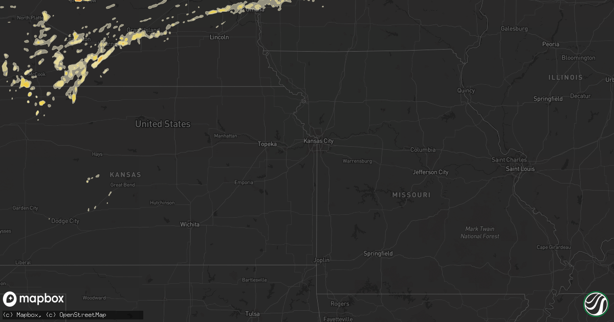
Hail Map in Iowa on July 10, 2011
Get this storm
July 10 map
$229
one time, instant access
Download today. No call, no setup
Keep the $229
Bought the map and want the full workflow? Apply the entire $229 to a subscription within 7 days. None of it is wasted.
Every map, not just this one
This buys you this map. Subscription and you get every map we run, in the markets you choose from a few cities to whole states to nationwide. Plus real-time alerts the moment a storm fires.
Contact data
Name, contact info, occupancy, even credit band for addresses in the footprint. You go from where it hit to who to call.
Become the source they trust
Unlimited branding weather history reports on demand. You already have the documented answer ready for the property owner, and you are the one who showed up with it.
Property data and RoofTrace estimates
Pull up any address you have got, its value and the exact code rules for that jurisdiction, straight from One Click Code. Then RoofTrace estimates the squares, pitch, and roof value, priced the way you price.
Storm reports in Iowa
Iowa
| Date | Description |
|---|---|
| 07/10/20116:30 AM CDT | 1 inch diameter limbs down in andrew. |
| 07/10/20116:30 AM CDT | Tree branches down blocking streets in maquoketa. Time estimated. Power outage. |
| 07/10/20116:25 AM CDT | Power lines down in town. Time estimated. |
| 07/10/20116:15 AM CDT | 3 trees blown over lewis access road blocking road to bridge across cedar river. |
| 07/10/20116:15 AM CDT | Large number of 12 to 16 inch trees down in town...delayed report. |
| 07/10/20116:15 AM CDT | Damage to shingles on home. |
| 07/10/20116:10 AM CDT | Also widespread crop damage. |
| 07/10/20116:10 AM CDT | A local report indicates 74 MPH wind near DUBUQUE REGIONAL AIRPOR |
| 07/10/20116:07 AM CDT | A local report indicates 64 MPH wind near DUBUQUE REGIONAL AIRPOR |
| 07/10/20116:02 AM CDT | 12 inch diameter trees down on property on top of an outbuilding. |
| 07/10/20116:00 AM CDT | Two large trees blown down. |
| 07/10/20116:00 AM CDT | A local report indicates 72 MPH wind near CHARLOTTE |
| 07/10/20115:55 AM CDT | A local report indicates 60 MPH wind near DUBUQUE REGIONAL AIRPOR |
| 07/10/20115:54 AM CDT | A local report indicates 65 MPH wind near 3 SSW CENTER JUNCTION |
| 07/10/20115:54 AM CDT | Top half of a 12 inch diameter pine tree snapped off. |
| 07/10/20115:50 AM CDT | Asbury area. 24 inch diameter tree split in half. Also 1.3 inches of rain with storm. |
| 07/10/20115:37 AM CDT | Windows broken in some homes...with some power outages being reported as well. |
| 07/10/20115:35 AM CDT | A local report indicates 66 MPH wind near MONTICELLO MUNICIPAL AI |
| 07/10/20115:30 AM CDT | Numerous trees blown over with some cars damaged. |
| 07/10/20115:30 AM CDT | 3 foot diameter tree blown down. Delayed report relayed by des moines nws office. |
| 07/10/20115:28 AM CDT | County ema reports trees down countywide. Occurred between about 520 am and 610 am. |
| 07/10/20115:27 AM CDT | Trees blown down |
| 07/10/20115:25 AM CDT | Numerous power outages reported in town as well as in alburnett. |
| 07/10/20115:24 AM CDT | Semi overturned at center point i-380 truck stop. |
| 07/10/20115:24 AM CDT | Time estimated from radar...relayed by emergency manager. |
| 07/10/20115:24 AM CDT | 60+ mph winds...relayed by emergency manager. |
| 07/10/20115:23 AM CDT | Time estimated from radar. |
| 07/10/20115:21 AM CDT | Metal building completely destroyed with numerous roofs blown over in town. |
| 07/10/20115:20 AM CDT | Lazy acres campground...camper flipped over...time estimated from radar. |
| 07/10/20115:16 AM CDT | 8 small utility size trailers blown over on i-380...lots of flattened crop damage in the area seen as well...time estimated from radar. |
| 07/10/20115:15 AM CDT | Time estimated from radar. |
| 07/10/20115:14 AM CDT | Interstate signs blown over near sunset st exit on i-380...many 4 inch diameter trees snapped off...time estimated from radar. |
| 07/10/20115:12 AM CDT | Time estimated from radar...relayed by emergency manager. |
| 07/10/20115:12 AM CDT | A local report indicates 70 MPH wind near 3 E CEDAR RAPIDS |
| 07/10/20115:12 AM CDT | Since 5 am have had sustained 60 mph winds...reported by county eoc. |
| 07/10/20115:11 AM CDT | A local report indicates 80 MPH wind near 1 SSE CEDAR RAPIDS |
| 07/10/20115:09 AM CDT | Estimated 55 to 60 mph. |
| 07/10/20115:05 AM CDT | 2x4 flew through exterior wall of home...knocking tv over inside home...time estimated from radar. |
| 07/10/20115:05 AM CDT | A local report indicates 60 MPH wind near 1 SSE CEDAR RAPIDS |
| 07/10/20115:03 AM CDT | Numerous 12 to 14 inch trees down in town...crop damage is also being seen. Time estimated from radar. |
| 07/10/20115:01 AM CDT | Semi blown off highway 150 just north of town. |
| 07/10/20115:00 AM CDT | 70+ mph winds being seen at this time. |
| 07/10/20114:58 AM CDT | Reported by benton eoc. |
| 07/10/20114:50 AM CDT | Large trees down in town with power outages reported on north side. |
| 07/10/20114:50 AM CDT | A local report indicates 60 MPH wind near BELLE PLAINE |
| 07/10/20114:49 AM CDT | A local report indicates 75 MPH wind near 3 SE KEYSTONE |
| 07/10/20114:41 AM CDT | Trees limbs down and power out. Swing set wrapped around a tree. |
| 07/10/20114:40 AM CDT | Numerous trees down...windows broke out and rescue crews called out. Time estimated from radar. Report relayed by kwwl tv. |
| 07/10/20114:35 AM CDT | Numerous trees down. No electricity in neighborhood. Time estimated from radar. Report relayed by kwwl tv. |
| 07/10/20114:35 AM CDT | Numerous trees down throughout town. Grain elevators destroyed...roofs damaged by falling trees...and spotters chimney destroyed by the wind. Time estimated from radar. |
| 07/10/20114:30 AM CDT | Many trees and fences down. Bins down at the coop and roof torn off of the legion hall. Possible natural gas leak noted. |
| 07/10/20114:25 AM CDT | Barn and brick silo flattened. Many trees down...some up to 3 ft in diameter. Time estimated from radar. |
| 07/10/20114:25 AM CDT | A 180 ft radio tower snapped and many trees down. |
| 07/10/20114:25 AM CDT | Trees and powerlines down all over the place. Time estimated from radar. Reported by kwwl. |
| 07/10/20114:23 AM CDT | Numerous large trees down with a couple on the house. Outbuilding damage at the residence as well. A funnel cloud was reported near time damage occurred. |
| 07/10/20114:22 AM CDT | 70 to 100 mph winds estimated between montour and toledo. Road signs blown down...power outages. |
| 07/10/20114:20 AM CDT | Measured on personal weather station. Damage noted includes fences down...trees snapped...and siding ripped from houses. |
| 07/10/20114:13 AM CDT | Semi blown over on highway 30...near le grand |
| 07/10/20114:12 AM CDT | Trees down...transformers down...power outages...high winds reported...no estimate of speed. |
| 07/10/20114:09 AM CDT | Extensive damage reported in marshalltown...trees over roads...trees on homes...gas leaks...possible structural damage. |
| 07/10/20114:05 AM CDT | 1 to 2 miles of topped trees along the haverhill blacktop just south of marshalltown. |
| 07/10/20114:04 AM CDT | Power poles snapped in half near highway 30...330 junction. |
| 07/10/20114:00 AM CDT | Delayed report. Time estimated from radar. Roof blown off building. |
| 07/10/20113:57 AM CDT | A local report indicates 64 MPH wind near NW BAXTER |
| 07/10/20113:50 AM CDT | Shed destroyed. Time estimated from radar. |
| 07/10/20113:45 AM CDT | Roof ripped off of a mobile home. Time estimated from radar. |
| 07/10/20113:43 AM CDT | 59 mph wind gust measured at amw asos. |
| 07/10/20113:35 AM CDT | Power lines down along hwy 69 near the polk county line. Time estimated from radar. |
| 07/10/20113:31 AM CDT | Some shingles ripped off the roof of a house. |
| 07/10/20113:31 AM CDT | A local report indicates 70 MPH wind near 5 NNW ANKENY AIRPORT |
| 07/10/20113:30 AM CDT | Who tv radar blown into a farm field and destroyed. |
| 07/10/20113:30 AM CDT | Numerous 10 to 12 inch in diameter trees snapped...largest trees downed were 3 ft in diameter. Trees laying in different directions. Power lines down across the area. A |
| 07/10/20113:25 AM CDT | Trees down and crop damage |
| 07/10/20113:25 AM CDT | Trees down |
| 07/10/20113:25 AM CDT | Spotter estimated 60 mph gust. |
| 07/10/20113:25 AM CDT | Several large tree branches down along merle hay road. Largest was four to five inches in diameter. Time estimated from radar. |
| 07/10/20113:25 AM CDT | Trees down |
| 07/10/20113:22 AM CDT | 4 inch limbs down...heavy rain...wind increasing |
| 07/10/20113:20 AM CDT | Corrugated steel roof from a house ripped off and thrown approximately 120 yards. A section of the roof impaled the side of a neighboring house...with part of the metal |
| 07/10/20113:20 AM CDT | Delayed report. Time estimated. 10 x 34 ft section of a newly constructed house roof blown off and trusses snapped in half. Several 18 to 24 ft diameter trees snapped o |
| 07/10/20113:05 AM CDT | A local report indicates 63 MPH wind near 4 S FORT DODGE |
| 07/10/20112:46 AM CDT | 2 to 4 inch diameter limbs down in yale. |
| 07/10/20112:30 AM CDT | Several large tree branches in area down. Heavy patio table with umbrella toppled and blown many feet. Damage to lawn furniture...garbage containers...yard decor...all |
| 07/10/20112:10 AM CDT | Tree down partially blocking highway 6. |
| 07/10/20112:00 AM CDT | Damage to a garage and branches down |
| 07/10/20111:55 AM CDT | A local report indicates 61 MPH wind near CHEROKEE |
| 07/10/20111:35 AM CDT | Branches and trees down. |
All States Impacted by Hail Map on July 10, 2011
Cities Impacted by Hail Map on July 10, 2011
- Floresville, TX
- Argyle, WI
- Blanchardville, WI
- Valley, NE
- Weston, NE
- Brainard, NE
- Gretna, NE
- Colon, NE
- Waterloo, NE
- Malmo, NE
- Wahoo, NE
- Ashland, NE
- Mead, NE
- Bennington, NE
- Fremont, NE
- Omaha, NE
- Prague, NE
- Elkhorn, NE
- Yutan, NE
- Pueblo, CO
- McDonald, KS
- Register, GA
- Arthur, NE
- Hankinson, ND
- Wahpeton, ND
- Ellendale, ND
- Forbes, ND
- Broken Bow, NE
- Merna, NE
- Ewing, NE
- Hyannis, NE
- De Soto, WI
- Wilsonville, NE
- Sully, IA
- Glen Ullin, ND
- New Leipzig, ND
- Almont, ND
- Trenton, NE
- Culbertson, NE
- Herndon, KS
- Watertown, WI
- Juneau, WI
- Lowell, WI
- Beaver Dam, WI
- Reeseville, WI
- Statesboro, GA
- Hanover, IL
- Elizabeth, IL
- Glenwood, MN
- Atwood, KS
- Sutherland, NE
- Juda, WI
- Brodhead, WI
- Archer, IA
- Primghar, IA
- Stapleton, NE
- Chassell, MI
- Lake Linden, MI
- Mandan, ND
- Saint Anthony, ND
- Bismarck, ND
- Palisade, NE
- Hancock, IA
- Montevideo, MN
- Sacred Heart, MN
- Maynard, MN
- Granite Falls, MN
- Brady, NE
- Genoa, CO
- Bellingham, MN
- Gibbon, NE
- Shelton, NE
- Oakland, IA
- Minden, IA
- Logandale, NV
- Wentworth, SD
- Strasburg, ND
- Fort Yates, ND
- Richardton, ND
- Elgin, ND
- Bennett, CO
- Kiowa, CO
- Warren, IL
- Gratiot, WI
- Miller, NE
- Fairmount, ND
- Cyrus, MN
- Starbuck, MN
- Hospers, IA
- Paxton, NE
- Agate, CO
- Elizabeth, CO
- Littlefield, AZ
- Pflugerville, TX
- Shullsburg, WI
- Darlington, WI
- Madison, MN
- Marietta, MN
- Dickinson, ND
- Mound City, SD
- Eureka, SD
- Larned, KS
- Leola, SD
- Holbrook, NE
- Arapahoe, NE
- Black Canyon City, AZ
- Baldwin, IA
- Waterloo, WI
- Columbus, WI
- New Salem, ND
- Mott, ND
- Ashley, ND
- Jackson, MN
- Lakefield, MN
- Grinnell, IA
- Tama, IA
- Temple, GA
- Buchanan, GA
- Holmen, WI
- Selfridge, ND
- Kintyre, ND
- Napoleon, ND
- Braddock, ND
- Fennimore, WI
- Lancaster, WI
- Osceola, NE
- Columbus, NE
- Silver Creek, NE
- State Center, IA
- Carson, ND
- Maxwell, NE
- Regent, ND
- Kulm, ND
- Lehr, ND
- Fredonia, ND
- Eustis, NE
- Cambridge, NE
- Boone, IA
- Ogden, IA
- Madrid, IA
- Hecla, SD
- La Crosse, WI
- Cashton, WI
- Ontario, WI
- Scranton, IA
- Jefferson, IA
- Amherst, NE
- Pleasanton, NE
- Hazard, NE
- Lefor, ND
- Gladstone, ND
- Hebron, ND
- Flasher, ND
- Taylor, ND
- Linton, ND
- Menoken, ND
- Dawson, ND
- Hazelton, ND
- Moffit, ND
- Tappen, ND
- Oxford, NE
- Stamford, NE
- Berlin, ND
- Blue Earth, MN
- Granada, MN
- Fairmont, MN
- Cogswell, ND
- Forman, ND
- Chaseburg, WI
- Templeton, IA
- Manning, IA
- Audubon, IA
- Stuart, NE
- Atkinson, NE
- Ravenna, NE
- Enterprise, AL
- Elba, AL
- New Brockton, AL
- Elk River, MN
- Hokah, MN
- Caliente, NV
- Anselmo, NE
- Arnold, NE
- Lidgerwood, ND
- Plymouth, WI
- Minburn, IA
- Fowler, CO
- Olney Springs, CO
- Florence, SD
- Jackson, WI
- Davis, IL
- Durand, IL
- Alexander, KS
- Lismore, MN
- Norton, KS
- Henning, MN
- Phillips, NE
- Alda, NE
- Wood River, NE
- Grand Island, NE
- Doniphan, NE
- Baraboo, WI
- Reedsburg, WI
- Villard, MN
- Alexandria, MN
- Saint Francis, KS
- Brooten, MN
- Sunburg, MN
- New London, MN
- Belgrade, MN
- Dawson, MN
- Revillo, SD
- Labolt, SD
- New Era, MI
- Shelby, MI
- Lenora, KS
- Terril, IA
- Java, SD
- Hosmer, SD
- Campbell, MN
- Runnells, IA
- Pleasant Hill, IA
- Palo, IA
- Dallas Center, IA
- Grimes, IA
- Bouton, IA
- Perry, IA
- Woodward, IA
- Polk City, IA
- Granger, IA
- Marion, AL
- Centreville, AL
- Lawley, AL
- Wakpala, SD
- Mobridge, SD
- Trail City, SD
- Malta, ID
- Elwood, NE
- Lexington, NE
- Norwalk, IA
- Cumming, IA
- Elbow Lake, MN
- Wendell, MN
- Garrison, IA
- Dysart, IA
- La Porte City, IA
- Vinton, IA
- Mount Auburn, IA
- Clutier, IA
- Winter, WI
- Rupert, GA
- Collins, GA
- Henderson, NE
- Callaway, NE
- Masonville, IA
- Walker, IA
- Urbana, IA
- Brandon, IA
- Center Point, IA
- Rowley, IA
- Coggon, IA
- Winthrop, IA
- Traer, IA
- Stoddard, WI
- Hugo, CO
- Cimarron, KS
- Camden, AL
- Mequon, WI
- Milwaukee, WI
- Bagley, IA
- Rippey, IA
- Grand Junction, IA
- Coon Valley, WI
- Edgeley, ND
- Mears, MI
- Hesperia, MI
- Hart, MI
- Woodstock, MN
- Lake Wilson, MN
- Fullerton, ND
- Bowdle, SD
- Frederick, SD
- Crofton, NE
- Bloomfield, NE
- Niobrara, NE
- Springfield, SD
- Wallingford, IA
- Estherville, IA
- Ansley, NE
- Whitehall, MI
- Muskegon, MI
- Twin Lake, MI
- Fremont, MI
- Holton, MI
- Rothbury, MI
- Coon Rapids, IA
- Reynolds, GA
- Butler, GA
- Flagler, CO
- Polk, NE
- Benedict, NE
- Hampton, NE
- Bradshaw, NE
- Tallapoosa, GA
- Fullerton, NE
- Genoa, NE
- Round Lake, MN
- Worthington, MN
- Kenesaw, NE
- Northport, AL
- Victor, IA
- Raymond, NE
- Davey, NE
- Glidden, IA
- Wilmot, SD
- Hartwick, IA
- Deforest, WI
- Rio, WI
- Arlington, WI
- Litchfield, NE
- Randolph, AL
- Westfield, IA
- Marshalltown, IA
- Swea City, IA
- Elmore, MN
- Aurora, NE
- Giltner, NE
- Lost Nation, IA
- Pipestone, MN
- Cozad, NE
- Avoca, IA
- Kearney, NE
- Sisseton, SD
- Peever, SD
- Adrian, MN
- Ellsworth, MN
- Stanton, AL
- Bangor, MI
- Alberta, AL
- Oberlin, KS
- Anoka, MN
- Whitman, NE
- Nordheim, TX
- Hartington, NE
- Florala, AL
- Adair, IA
- New London, WI
- Oakes, ND
- Monroe, WI
- Monticello, WI
- Browntown, WI
- Selden, KS
- Arriba, CO
- Gwinner, ND
- Stirum, ND
- Wellfleet, NE
- Curtis, NE
- Maywood, NE
- West Salem, WI
- Onalaska, WI
- Tryon, NE
- Montague, MI
- Farwell, MN
- Toledo, IA
- Nevada, IA
- Ames, IA
- Egan, SD
- Trent, SD
- Flandreau, SD
- Elbert, CO
- Naponee, NE
- Wilcox, NE
- Prairie City, IA
- Stratford, SD
- Groton, SD
- Okabena, MN
- Ridott, IL
- Pecatonica, IL
- Rock City, IL
- Loomis, NE
- Atlanta, NE
- Holdrege, NE
- Searsboro, IA
- Lynnville, IA
- Reasnor, IA
- Pella, IA
- New Sharon, IA
- Dakota, MN
- Winona, MN
- Shellman, GA
- Potosi, WI
- Colfax, IA
- Axtell, NE
- Minden, NE
- Funk, NE
- Edison, NE
- Stevens Point, WI
- Panora, IA
- Guthrie Center, IA
- Yale, IA
- Lyndon Station, WI
- Rock Springs, WI
- Poynette, WI
- Lodi, WI
- La Valle, WI
- Merrimac, WI
- North Freedom, WI
- Overton, NE
- Lisbon, ND
- Montrose, CO
- Maxwell, IA
- Olin, IA
- Clarence, IA
- Oxford Junction, IA
- Mechanicsville, IA
- Wheatland, IA
- Stanwood, IA
- Lowden, IA
- Stratton, NE
- Wauneta, NE
- Benkelman, NE
- Spirit Lake, IA
- Milford, IA
- North Platte, NE
- Moorefield, NE
- Stromsburg, NE
- Guttenberg, IA
- Holy Cross, IA
- Orlando, FL
- D Hanis, TX
- Shelby, NE
- Loup City, NE
- Mitchellville, IA
- Johnstown, NE
- Green Valley, AZ
- Soldiers Grove, WI
- Larchwood, IA
- Dyersville, IA
- Worthington, IA
- Earlville, IA
- Carroll, IA
- Arcadia, IA
- Chipley, FL
- Bonifay, FL
- Lebanon, NE
- Weyauwega, WI
- Wiota, IA
- Anita, IA
- Tucson, AZ
- Kingsland, GA
- Hilliard, FL
- Folkston, GA
- White Oak, GA
- Sherrill, IA
- Colo, IA
- Arlington, CO
- Cambridge, IA
- Williamsburg, IA
- Oxford, IA
- Pollock, SD
- Britton, SD
- Malcom, IA
- Montezuma, IA
- Sumner, NE
- Ipswich, SD
- San Antonio, TX
- Muscadine, AL
- Ironwood, MI
- Wishek, ND
- Bertrand, NE
- Beaver City, NE
- Kinston, AL
- Arnolds Park, IA
- Okoboji, IA
- Tohatchi, NM
- Bird City, KS
- Stratford, IA
- Stanhope, IA
- Marion, IA
- Springville, IA
- Lyons, GA
- Zeeland, ND
- Elkhart Lake, WI
- Barnes City, IA
- Fort Ransom, ND
- Richland Center, WI
- Timewell, IL
- Camden, IL
- Pardeeville, WI
- Portage, WI
- Webster, SD
- Lawrence, MI
- Paw Paw, MI
- Hartford, MI
- Shellsburg, IA
- Fall River, WI
- Randolph, WI
- Mount Hope, WI
- Sahuarita, AZ
- Pennock, MN
- Akron, IA
- Elk Point, SD
- Le Mars, IA
- Marengo, IA
- South Amana, IA
- Maquoketa, IA
- Verona, ND
- Lamoure, ND
- Eden, SD
- Ramer, AL
- McCook, NE
- Hague, ND
- Fargo, GA
- Du Pont, GA
- Statenville, GA
- Monroe, NE
- Hastings, NE
- Wyoming, IA
- Blue River, WI
- Bangor, WI
- Hillpoint, WI
- Lone Rock, WI
- Grant, MI
- Montour, IA
- Mount Sterling, IL
- Colesburg, IA
- New Vienna, IA
- Holland, MN
- Ruthton, MN
- Dickey, ND
- Overton, NV
- Eufaula, AL
- Midway, AL
- Maple Lake, MN
- Annandale, MN
- La Crescent, MN
- Graettinger, IA
- Carson, IA
- Council Bluffs, IA
- Walnut, IA
- Underwood, IA
- Neola, IA
- McClelland, IA
- Crescent, IA
- Carter Lake, IA
- Treynor, IA
- Honey Creek, IA
- Lewis, IA
- Barrett, MN
- Moose Lake, MN
- Kettle River, MN
- Cedar Rapids, IA
- Toddville, IA
- Hiawatha, IA
- Robins, IA
- Elk Horn, IA
- Marne, IA
- Atlantic, IA
- Brayton, IA
- Shelby, IA
- Garretson, SD
- Jasper, MN
- Galena, IL
- Hazel Green, WI
- East Dubuque, IL
- Casey, IA
- Fountain City, WI
- Lowry, MN
- Ulysses, NE
- Hartland, WI
- Colgate, WI
- Houston, MN
- Malad City, ID
- Morris, MN
- Central City, IA
- Wausa, NE
- Kinsley, KS
- Offerle, KS
- Marion Junction, AL
- Orrville, AL
- Ledyard, IA
- Montgomery, AL
- Brantley, AL
- Anamosa, IA
- Clayton, AL
- Monticello, MN
- Big Lake, MN
- West Bend, WI
- Clearwater, NE
- Gays Mills, WI
- Sparta, WI
- Black River Falls, WI
- Gladbrook, IA
- Clear Lake, MN
- Ladora, IA
- Gilman, IA
- Kellogg, IA
- Renville, MN
- Nekoma, KS
- Danube, MN
- Olivia, MN
- Charlotte, IA
- Goose Lake, IA
- De Witt, IA
- Barney, ND
- Comstock, NE
- Westerville, NE
- Arcadia, NE
- Bellevue, IA
- Farley, IA
- Hopkinton, IA
- Deer Trail, CO
- Ramah, CO
- Gackle, ND
- Streeter, ND
- Punta Gorda, FL
- Pawnee Rock, KS
- Elm Creek, NE
- Rising City, NE
- David City, NE
- Viroqua, WI
- Genoa, WI
- Caledonia, MN
- Hartford, WI
- Oconomowoc, WI
- Lebanon, WI
- Ixonia, WI
- Rubicon, WI
- Ashippun, WI
- Neosho, WI
- Ravenna, MI
- Tuscaloosa, AL
- Palmer, NE
- Safford, AL
- Hordville, NE
- Nogales, AZ
- Rutland, ND
- Heron Lake, MN
- Hortense, GA
- Dixon, IL
- Rockland, WI
- Vona, CO
- Mantador, ND
- Orleans, NE
- Alma, NE
- Hayes Center, NE
- La Crosse, KS
- Magnet, NE
- Mclean, NE
- Randolph, NE
- Wyndmere, ND
- Coleridge, NE
- Lake Benton, MN
- Dresden, KS
- Jennings, KS
- Coalville, UT
- Guernsey, IA
- Monroe, IA
- Simla, CO
- White Cloud, MI
- Walkerville, MI
- Newaygo, MI
- Orangeville, IL
- Tanner, AL
- Windom, MN
- Huxley, IA
- Clemons, IA
- Saint Anthony, IA
- Melbourne, IA
- McCallsburg, IA
- Roland, IA
- Collins, IA
- Story City, IA
- Zearing, IA
- Tony, WI
- Page, NE
- Menlo, IA
- Ringsted, IA
- Superior, IA
- Vining, MN
- Long Lake, SD
- Albany, WI
- Prentice, WI
- Brantwood, WI
- Norcatur, KS
- Republican City, NE
- Hildreth, NE
- Smithfield, NE
- Astoria, IL
- Rushville, IL
- Westby, WI
- Martelle, IA
- Mount Vernon, IA
- Dayton, MN
- Becker, MN
- Saint Michael, MN
- Buffalo, MN
- Albertville, MN
- Rogers, MN
- Slayton, MN
- Balaton, MN
- Castle Rock, CO
- Linden, IA
- Bartley, NE
- Farnam, NE
- Albion, NE
- Glen Haven, WI
- Cassville, WI
- Armstrong, IA
- Norwalk, WI
- Stockholm, SD
- Shields, ND
- Sargent, NE
- Limon, CO
- Clarkfield, MN
- Saint Helena, NE
- Fordyce, NE
- Columbia, SD
- Houghton, SD
- Surprise, NE
- Laurel, NE
- Grenville, SD
- Tampico, IL
- Riverdale, NE
- Garfield, MN
- Fond Du Lac, WI
- Eden, WI
- Fort Dodge, IA
- Veblen, SD
- Chandler, MN
- Platteville, WI
- Warrens, WI
- Cobbtown, GA
- Metter, GA
- Wonewoc, WI
- Elroy, WI
- Fort Gaines, GA
- Abbeville, AL
- Chapman, NE
- Saint Libory, NE
- Donnelly, MN
- Hancock, MN
- Buckeye, AZ
- Newton, IA
- Sheboygan Falls, WI
- Keystone, NE
- Center, NE
- Verdigre, NE
- Hendley, NE
- Readstown, WI
- Lanark, IL
- Milnor, ND
- Galesville, WI
- Westport, SD
- Brunswick, GA
- Waverly, GA
- Waynesville, GA
- Ridgway, CO
- Waubay, SD
- Dalton, WI
- Dell Rapids, SD
- Colman, SD
- Monticello, IA
- Gresham, NE
- Ralston, IA
- Osmond, NE
- Stockville, NE
- Newcastle, NE
- Defuniak Springs, FL
- La Motte, IA
- Zwingle, IA
- Hawkinsville, GA
- Trempealeau, WI
- Brewster, MN
- South Shore, SD
- Watertown, SD
- Oostburg, WI
- Cedar Grove, WI
- Waldo, WI
- Winnetoon, NE
- Creighton, NE
- Junction City, WI
- Custer, WI
- Rosholt, WI
- Aberdeen, SD
- Quasqueton, IA
- Van Meter, IA
- Booneville, IA
- Waukee, IA
- West Des Moines, IA
- Sun Prairie, WI
- Marshall, WI
- Adell, WI
- Fredonia, WI
- Random Lake, WI
- Campbellsport, WI
- Cascade, WI
- Kewaskum, WI
- Savanna, IL
- Ainsworth, NE
- Selby, SD
- Carlisle, IA
- Des Moines, IA
- Indianola, IA
- Swan, IA
- Hartford, IA
- Pleasantville, IA
- Glenbeulah, WI
- Glenwood, AL
- Vesper, WI
- Titus, AL
- Cascade, IA
- Albany, IL
- Fruitport, MI
- Spring Lake, MI
- Ceresco, NE
- Cazenovia, WI
- Inman, NE
- Maplesville, AL
- Brooklyn, IA
- Chelsea, IA
- Hardwick, MN
- Luverne, MN
- Ryan, IA
- Odessa, NE
- Cedartown, GA
- Bayard, IA
- Edgerton, MN
- Lockney, TX
- Chippewa Falls, WI
- Sanderson, FL
- Brandon, MN
- Kensington, MN
- Tulare, SD
- Shorterville, AL
- Bruce, SD
- Toronto, SD
- Rocksprings, TX
- Ladysmith, WI
- Bruce, WI
- Sutherland, IA
- Paullina, IA
- Athens, AL
- Kenneth, MN
- Mentone, AL
- Medina, TX
- Hondo, TX
- Dickens, IA
- Spencer, IA
- Hershey, NE
- Cedar Rapids, NE
- Garwin, IA
- Barnard, SD
- Greenfield, IA
- Fontanelle, IA
- Burlington, CO
- Dedham, IA
- Mineral Point, WI
- Cuba City, WI
- Belmont, WI
- Goodland, KS
- Sheboygan, WI
- Dakota, IL
- Roscoe, SD
- Long Prairie, MN
- Spicer, MN
- Atwater, MN
- Iron Ridge, WI
- Horicon, WI
- Hustisford, WI
- Warner, SD
- Coker, AL
- Buhl, AL


