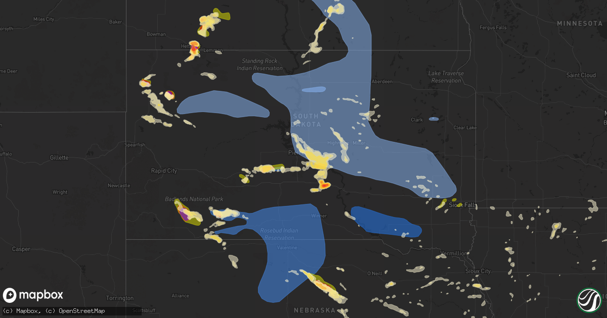
Hail Map in South Dakota on July 9, 2025
Get this storm
July 9 map
$229
one time, instant access
Download today. No call, no setup
Keep the $229
Bought the map and want the full workflow? Apply the entire $229 to a subscription within 7 days. None of it is wasted.
Every map, not just this one
This buys you this map. Subscription and you get every map we run, in the markets you choose from a few cities to whole states to nationwide. Plus real-time alerts the moment a storm fires.
Contact data
Name, contact info, occupancy, even credit band for addresses in the footprint. You go from where it hit to who to call.
Become the source they trust
Unlimited branding weather history reports on demand. You already have the documented answer ready for the property owner, and you are the one who showed up with it.
Property data and RoofTrace estimates
Pull up any address you have got, its value and the exact code rules for that jurisdiction, straight from One Click Code. Then RoofTrace estimates the squares, pitch, and roof value, priced the way you price.
Storm reports in South Dakota
South Dakota
| Date | Description |
|---|---|
| 07/09/20256:39 PM CDT | Mesonet station 178 trail city |
| 07/09/20256:30 PM CDT | Mesonet station tims2 timber lake (sd mesone |
| 07/09/20256:30 PM CDT | Mesonet station tims2 timber lake |
| 07/09/20256:28 PM CDT | A local report indicates 72 MPH wind near 6 W Parmelee |
| 07/09/20256:26 PM CDT | A local report indicates 70 MPH wind near 11 NE Vetal |
| 07/09/20256:13 PM CDT | Personal weather station. |
| 07/09/20255:50 PM CDT | A local report indicates 60 MPH wind near 5 ENE Martin |
| 07/09/20255:30 PM CDT | A local report indicates 79 MPH wind near 4 E Martin |
| 07/09/20255:25 PM CDT | A local report indicates 60 MPH wind near 5 SE Usta |
| 07/09/20255:24 PM CDT | A local report indicates 59 MPH wind near 1 NNE Faith |
| 07/09/20255:12 PM CDT | A local report indicates 60 MPH wind near 2 ENE Kyle |
| 07/09/20255:09 PM CDT | A local report indicates 64 MPH wind near Usta |
| 07/09/20254:59 PM CDT | A local report indicates 60 MPH wind near 8 WSW Swett |
| 07/09/20254:40 PM CDT | A local report indicates 60 MPH wind near 8 SE Mud Butte |
| 07/09/20254:34 PM CDT | A local report indicates 61 MPH wind near 1 ENE Mud Butte |
| 07/09/20254:24 PM CDT | A local report indicates 62 MPH wind near 1 ENE Mud Butte |
| 07/09/20254:00 PM CDT | A local report indicates 1.50 inch wind near 19 E Redig |
| 07/09/202511:50 AM CDT | Report of car blown off road north of henry. Additional report of debris on roads in henry from winds a couple mins earlier. |
| 07/09/20251:04 AM CDT | Report from mping: quarter (1.00 i |
| 07/09/20251:04 AM CDT | Report from mping: quarter |
| 07/09/202512:49 AM CDT | Report from mping: quarter |
| 07/09/202512:46 AM CDT | Mostly pea to dime sized hail... But some as big as quarters. |
| 07/09/202512:44 AM CDT | Personal weather station. |
| 07/09/202512:42 AM CDT | Report from mping: quarter |
| 07/09/202512:15 AM CDT | Report from mping: quarter |
| 07/08/202511:50 PM CDT | Corrects time of previous tstm wnd dmg report from 1 nnw henry. Report of car blown off road north of henry. Additional report of debris on roads in henry from winds a |
| 07/08/202511:24 PM CDT | Personal weather station. |
| 07/08/202510:46 PM CDT | Mesonet station 26 sd rwis tripp. |
| 07/08/202510:45 PM CDT | A local report indicates 1.00 inch wind near Tyndall |
| 07/08/202510:34 PM CDT | Asos station khon huron regional airport. |
| 07/08/202510:32 PM CDT | Perso |
| 07/08/202510:32 PM CDT | Personal weather station. |
| 07/08/202510:31 PM CDT | Mesonet station 164 sd rwis wolsey. |
| 07/08/202510:10 PM CDT | Mesonet station wgms2 wessington 3w |
| 07/08/20259:50 PM CDT | Greater than 4 inch diameter branch broken off tree. Radar estimated time. |
| 07/08/20259:42 PM CDT | Mesonet station 201 gann valley |
| 07/08/20259:20 PM CDT | Emergency manager relayed photos of 3 snapped power poles and many haybales rolled from west to east across a field. Radar estimated time. |
| 07/08/20259:17 PM CDT | Meso |
| 07/08/20259:17 PM CDT | Mesonet station 183 macs corner |
| 07/08/20259:10 PM CDT | Personal weather station. (fs |
| 07/08/20259:10 PM CDT | Personal weather station. |
| 07/08/20259:07 PM CDT | Mesonet station 154 sd rwis platte-winner bridge. |
| 07/08/20259:02 PM CDT | A local report indicates 66 MPH wind near Howes |
| 07/08/20259:00 PM CDT | Mesonet station lbms2 lower brule 2wnw |
| 07/08/20258:55 PM CDT | Emergency manager reports golf ball size hail in the area of west bed rec area. No damage at west bend. Radar estimated time. |
| 07/08/20258:50 PM CDT | Cornfield crop damage from hail and wind. |
| 07/08/20258:40 PM CDT | Mesonet station hmms2 highmore 23n |
| 07/08/20258:35 PM CDT | Mesonet station pims2 pierre 17e |
| 07/08/20258:33 PM CDT | Mping comments include reports of broken branches... Power lines damaged and poles shifted. |
| 07/08/20258:30 PM CDT | Winds estimated at 50 to 60 mph. |
| 07/08/20258:22 PM CDT | Mesonet station 215 polo 17 w jct sd47/sd26 |
| 07/08/20258:18 PM CDT | Mesonet station 19 harrold |
| 07/08/20258:04 PM CDT | A local report indicates 1.00 inch wind near 2 ENE Overlook Rec Area |
| 07/08/20257:59 PM CDT | Spotter reports hen egg to tennis ball size hail near lyman. Time estimated based on radar. |
| 07/08/20257:55 PM CDT | A local report indicates 62 MPH wind near 3 ENE Midland |
| 07/08/20257:53 PM CDT | Corrects previous high sust winds report from 1 e pierre regional airport. Asos station kpir pierre muni ap. |
| 07/08/20257:50 PM CDT | A local report indicates 1.00 inch wind near 8 N Kadoka |
| 07/08/20257:50 PM CDT | Corrects previous high sust winds report from 2 n herreid. Mesonet station 50 herreid |
| 07/08/20257:45 PM CDT | A local report indicates 72 MPH wind near 4 SSE Witten |
| 07/08/20257:45 PM CDT | Mesonet station onms2 onida 13wsw |
| 07/08/20257:40 PM CDT | A local report indicates 64 MPH wind near 4 SSE Witten |
| 07/08/20257:35 PM CDT | Mesonet station lrms2 lowry 2s |
| 07/08/20257:35 PM CDT | Mesonet station 212 agar |
| 07/08/20257:34 PM CDT | A local report indicates 60 MPH wind near Selby |
| 07/08/20257:30 PM CDT | Mesonet station 209 lowry |
| 07/08/20257:30 PM CDT | Mesonet station 212 agar |
| 07/08/20257:30 PM CDT | Mesonet station 157 forest city |
| 07/08/20257:22 PM CDT | A local report indicates 62 MPH wind near 15 SSE Mission |
| 07/08/20257:16 PM CDT | A local report indicates 61 MPH wind near Mobridge Municipal Airp |
| 07/08/20257:15 PM CDT | Three broken power poles in mobridge. Previously damaged roof of business shop now completely ripped off. |
| 07/08/20257:10 PM CDT | A local report indicates 63 MPH wind near 15 SSE Mission |
| 07/08/20257:00 PM CDT | Sdsu mesonet site 1 wnw of laplant. |
All States Impacted by Hail Map on July 9, 2025
Cities Impacted by Hail Map on July 9, 2025
- Comanche, TX
- Newburg, ND
- Balfour, ND
- Saint Edward, NE
- Alapaha, GA
- Pullman, WV
- West Union, WV
- Berea, WV
- Auburn, WV
- New Milton, WV
- Harrisville, WV
- Pennsboro, WV
- Willacoochee, GA
- Ambrose, GA
- Whitesburg, KY
- Rochelle, GA
- Weston, WV
- Camden, WV
- Douglas, GA
- Hawkinsville, GA
- Pearson, GA
- Axson, GA
- Ermine, KY
- Nicholls, GA
- Abbeville, GA
- Roanoke, VA
- Pineview, GA
- Eastman, GA
- Troutville, VA
- Broxton, GA
- Gassaway, WV
- Cedarville, WV
- Exchange, WV
- Camilla, GA
- Cadwell, GA
- Waycross, GA
- Denton, GA
- Hazlehurst, GA
- Tarrytown, GA
- Cochran, GA
- Eagle Rock, VA
- Gable, SC
- Rhine, GA
- Ailey, GA
- Burnsville, WV
- Olanta, SC
- Milan, GA
- Flatwoods, WV
- Keysville, GA
- Waynesboro, GA
- Vidalia, GA
- Stapleton, GA
- Avera, GA
- Louisville, GA
- Eutawville, SC
- Napier, WV
- Walkersville, WV
- Heaters, WV
- Ireland, WV
- Alamo, GA
- McRae Helena, GA
- Jacksonville, GA
- Dorchester, SC
- Scranton, SC
- Collettsville, NC
- Lyons, GA
- Metter, GA
- Lumber City, GA
- Guyton, GA
- Rincon, GA
- Cross, SC
- Twin City, GA
- Mount Vernon, GA
- Uvalda, GA
- Glenwood, GA
- Holly Hill, SC
- Millen, GA
- Buffalo, SD
- Soperton, GA
- Garfield, GA
- Aiken, SC
- Lovingston, VA
- Denver City, TX
- Greenville, MI
- Sandy Level, VA
- Bowman, SC
- Reevesville, SC
- Saint George, SC
- Lehigh Acres, FL
- Branchville, SC
- Sardis, GA
- Windsor, SC
- Martinsville, VA
- Claxton, GA
- Fort Stewart, GA
- Rocky Ford, GA
- Sylvania, GA
- Ponce De Leon, FL
- Tampa, FL
- Belding, MI
- Rockford, MI
- Barnwell, SC
- Butler, GA
- Harbor Beach, MI
- Leesville, SC
- Okeechobee, FL
- Cape Coral, FL
- Arrington, VA
- Shipman, VA
- Schuyler, VA
- Wingina, VA
- Junction City, GA
- Pittsville, VA
- Vero Beach, FL
- Statesboro, GA
- Ruth, MI
- Wagener, SC
- Spencer, VA
- Corrigan, TX
- Moscow, TX
- Williston, SC
- Esmont, VA
- Ridgeway, VA
- Salley, SC
- Fairfax, SC
- Brunson, SC
- Prairie City, SD
- Springfield, SC
- Sanford, FL
- Lake Mary, FL
- Reva, SD
- Lodgepole, SD
- Penhook, VA
- Midville, GA
- Walnut Cove, NC
- Madison, NC
- Mayodan, NC
- Gretna, VA
- Chatham, VA
- Live Oak, FL
- Pelion, SC
- Batesburg, SC
- Lancaster, SC
- Heath Springs, SC
- Neeses, SC
- Pageland, SC
- Monroe, NC
- Winston Salem, NC
- Lemmon, SD
- Hettinger, ND
- Axton, VA
- Pine Hall, NC
- Walkertown, NC
- Mousie, KY
- Concord, VA
- North Fort Myers, FL
- Geneva, FL
- Marshville, NC
- Wingate, NC
- Clermont, FL
- Pine Ridge, SD
- Fairburn, SD
- Union Grove, NC
- Wayland, KY
- Raven, KY
- Red House, VA
- Mott, ND
- Allendale, SC
- Peachland, NC
- Polkton, NC
- Midland, VA
- Warrenton, VA
- Punta Gorda, FL
- Winter Garden, FL
- Kissimmee, FL
- Oviedo, FL
- Swansea, SC
- North, SC
- Blairs, VA
- Keeling, VA
- Vernon Hill, VA
- Orlando, FL
- Winnsboro, SC
- Great Falls, SC
- Remington, VA
- Bealeton, VA
- Bumpass, VA
- Spotsylvania, VA
- Mineral, VA
- Belews Creek, NC
- Newberry, SC
- Prosperity, SC
- Pomaria, SC
- Blair, SC
- Wounded Knee, SD
- Farmville, VA
- Keysville, VA
- Harmony, NC
- Catlett, VA
- Davenport, FL
- Stoneville, NC
- Java, VA
- South Boston, VA
- Appomattox, VA
- Brookneal, VA
- Stokesdale, NC
- Summerfield, NC
- Hampden Sydney, VA
- Nathalie, VA
- Conestoga, PA
- Millersville, PA
- Washington Boro, PA
- Eden, NC
- Bison, SD
- Meadow, SD
- Kernersville, NC
- Minden City, MI
- Albertville, AL
- Manderson, SD
- Porcupine, SD
- Bradley, SC
- Elkwood, VA
- Avon Park, FL
- Reidsville, NC
- Windermere, FL
- Meherrin, VA
- Green Bay, VA
- New London, NC
- Richfield, NC
- Crossville, AL
- Boaz, AL
- Cascade, VA
- Wrightsville, PA
- Oak Ridge, NC
- Denton, NC
- Wanblee, SD
- Allen, SD
- Kyle, SD
- Greensboro, NC
- Martin, SD
- Phenix, VA
- Charlotte Court House, VA
- Crewe, VA
- Polk City, FL
- Okatie, SC
- Bluffton, SC
- Arcadia, FL
- Felton, PA
- Lancaster, PA
- Rice, VA
- Wadesboro, NC
- Batesland, SD
- Mud Butte, SD
- Faith, SD
- Hampton, SC
- Varnville, SC
- Claremont, NC
- Rock Hill, SC
- High Point, NC
- Lexington, NC
- Catawba, NC
- Newton, NC
- Conover, NC
- Willow Street, PA
- Clifton, TX
- Asheboro, NC
- Sophia, NC
- Drakes Branch, VA
- Saxe, VA
- New Leipzig, ND
- Elon, NC
- Union Point, GA
- Randleman, NC
- Colfax, NC
- Burkeville, VA
- Thomasville, NC
- Red Lion, PA
- Browns Summit, NC
- Brogue, PA
- Stewartstown, PA
- Halifax, VA
- Long Valley, SD
- Norris, SD
- Burlington, NC
- Alto, TX
- Airville, PA
- Oxford, NC
- Nelson, VA
- Virgilina, VA
- Bullock, NC
- Tuthill, SD
- Dupree, SD
- Lantry, SD
- Eagle Butte, SD
- Newell, SD
- Stem, NC
- New Park, PA
- Liberty, NC
- Anniston, AL
- Gordon, NE
- Ona, FL
- McLaughlin, SD
- Timber Lake, SD
- Isabel, SD
- Belle Fourche, SD
- Mebane, NC
- Haw River, NC
- Julian, NC
- Climax, NC
- Whitsett, NC
- Chester, SC
- Maiden, NC
- Pequea, PA
- Rougemont, NC
- Trail City, SD
- Glencross, SD
- Whitehorse, SD
- Wakpala, SD
- Roundup, MT
- Graham, NC
- Lincolnton, NC
- Malone, TX
- Elgin, ND
- Glen Ullin, ND
- Bynum, TX
- Merriman, NE
- Wilton, ND
- Taylor, ND
- Gladstone, ND
- Richardton, ND
- Shelby, NC
- Lawndale, NC
- Strasburg, PA
- Baldwin, ND
- Regan, ND
- Clyde, OH
- Atlanta, GA
- Menoken, ND
- Sterling, ND
- Presho, SD
- Llano, TX
- Hague, VA
- Mcclusky, ND
- Mobridge, SD
- Selby, SD
- Glenham, SD
- Gettysburg, SD
- Akaska, SD
- Pierre, SD
- Agar, SD
- Onida, SD
- Hoven, SD
- Java, SD
- Bowdle, SD
- Eureka, SD
- Mound City, SD
- Bismarck, ND
- Hillsboro, TX
- Saint Francis, SD
- Kilgore, NE
- Crookston, NE
- Mission, SD
- Sparks, NE
- Springview, NE
- Valentine, NE
- Mullen, NE
- Thedford, NE
- Johnstown, NE
- Wood Lake, NE
- Seneca, NE
- Parmelee, SD
- Mandan, ND
- Okreek, SD
- Wood, SD
- White River, SD
- Winner, SD
- Witten, SD
- Rosebud, SD
- Vickery, OH
- Kennebec, SD
- Orange, VA
- Louisa, VA
- Elsmere, NE
- Ainsworth, NE
- Long Pine, NE
- Colbert, GA
- Crawford, GA
- Athens, GA
- North Port, FL
- Kershaw, SC
- Brandy Station, VA
- Harrold, SD
- Blunt, SD
- Fort Pierre, SD
- Lebanon, SD
- Holabird, SD
- Highmore, SD
- Lower Brule, SD
- Tolstoy, SD
- Hosmer, SD
- Ree Heights, SD
- Onaka, SD
- Orient, SD
- Roscoe, SD
- Stephan, SD
- Seneca, SD
- Fort Thompson, SD
- Miller, SD
- Faulkton, SD
- Saint Lawrence, SD
- Ipswich, SD
- Rockham, SD
- Cresbard, SD
- Tulare, SD
- Northville, SD
- Mansfield, SD
- Westport, SD
- Leola, SD
- Kulm, ND
- Fredonia, ND
- Forbes, ND
- Long Lake, SD
- Ellendale, ND
- Ashley, ND
- Edgeley, ND
- Frederick, SD
- Gackle, ND
- Lehr, ND
- Jud, ND
- Wishek, ND
- Streeter, ND
- Medina, ND
- Tappen, ND
- Napoleon, ND
- Dawson, ND
- Steele, ND
- Zeeland, ND
- Linton, ND
- Braddock, ND
- Kintyre, ND
- Driscoll, ND
- York, ND
- Burke, SD
- Wing, ND
- Herreid, SD
- Hague, ND
- Pollock, SD
- Robinson, ND
- Kinsale, VA
- Marco Island, FL
- Covington, GA
- Jacksonville, TX
- Leeds, ND
- Strasburg, ND
- Monroe, GA
- Sheyenne, ND
- Stapleton, NE
- Reliance, SD
- Henderson, NC
- Oxford, GA
- Harvey, ND
- Maddock, ND
- Lancaster, MN
- Oberon, ND
- Arnold, NE
- Watkinsville, GA
- Cleveland, ND
- Jamestown, ND
- Winterville, GA
- Callaway, NE
- Jefferson, TX
- Tolna, ND
- New Rockford, ND
- Goodland, FL
- Saint Michael, ND
- Warwick, ND
- Arnoldsville, GA
- Junction, TX
- Lynch, NE
- Ennis, TX
- Gann Valley, SD
- Kimball, SD
- Wessington, SD
- Wessington Springs, SD
- Alpena, SD
- Letcher, SD
- Plankinton, SD
- Woonsocket, SD
- Virgil, SD
- Wolsey, SD
- Fulton, SD
- Mitchell, SD
- Artesian, SD
- Carthage, SD
- Huron, SD
- De Smet, SD
- Hitchcock, SD
- Yale, SD
- Cavour, SD
- Fedora, SD
- Iroquois, SD
- Redfield, SD
- Page, NE
- Avon, SD
- Ewing, NE
- Orchard, NE
- Brady, NE
- Fort Myers, FL
- Blooming Grove, TX
- Verdigre, NE
- Oconto, NE
- Ringgold, VA
- Danville, VA
- Strandquist, MN
- Clearwater, NE
- Rice, TX
- Gothenburg, NE
- Barry, TX
- Creighton, NE
- Winnetoon, NE
- Petersburg, NE
- Elgin, NE
- Chambers, NE
- Italy, TX
- Center, NE
- Scotland, SD
- Delmont, SD
- Armour, SD
- Tripp, SD
- Parkston, SD
- Olivet, SD
- Cozad, NE
- Cathay, ND
- Yanceyville, NC
- Durham, NC
- Ashton, SD
- Midland, SD
- Tabor, SD
- Karlstad, MN
- Philip, SD
- Kadoka, SD
- Bloomfield, NE
- Wausa, NE
- Albion, NE
- Greenbush, MN
- Bartlett, NE
- Chapel Hill, NC
- Platte, SD
- Geddes, SD
- Harrison, SD
- Corsica, SD
- Wagner, SD
- Lake Andes, SD
- Dante, SD
- Tyndall, SD
- Kaylor, SD
- New Holland, SD
- Lesterville, SD
- Menno, SD
- Colome, SD
- Ideal, SD
- Canova, SD
- Alexandria, SD
- Howard, SD
- Spencer, SD
- Winfred, SD
- Oldham, SD
- Salem, SD
- Strathcona, MN
- Newfolden, MN
- Neligh, NE
- Fordyce, NE
- Hartington, NE
- Okaton, SD
- Battle Creek, NE
- Meadow Grove, NE
- Pierce, NE
- Belvidere, SD
- Scotia, NE
- Osmond, NE
- Mclean, NE
- Viking, MN
- Warren, MN
- Bishop, GA
- Ramona, SD
- Lake Preston, SD
- Madison, SD
- Union Center, SD
- Lexington, NE
- Murdo, SD
- Randolph, NE
- Wynot, NE
- Marion, SD
- Bridgewater, SD
- Belden, NE
- The Colony, TX
- Carrollton, TX
- Tilden, NE
- Montrose, SD
- Colton, SD
- Humboldt, SD
- Hartford, SD
- Canistota, SD
- Wentworth, SD
- Chester, SD
- Palmer, NE
- Wolbach, NE
- Humphrey, NE
- Winside, NE
- Draper, SD
- Vivian, SD
- Amherst, NE
- Laurel, NE
- Monroe, SD
- Milford, DE
- Carroll, NE
- Wayne, NE
- Platte Center, NE
- Monroe, NE
- Ravenna, NE
- Grand Island, NE
- Cairo, NE
- Wood River, NE
- Alda, NE
- Shelton, NE
- Pleasanton, NE
- Gibbon, NE
- Riverdale, NE
- Miller, NE
- Kearney, NE
- Thief River Falls, MN
- Fisher, MN
- East Grand Forks, MN
- Euclid, MN
- Creston, NE
- Parker, SD
- Stromsburg, NE
- Clarks, NE
- Grace City, ND
- Leigh, NE
- Columbus, NE
- Kenesaw, NE
- Polk, NE
- Wakefield, NE
- Minden, NE
- Juniata, NE
- Doniphan, NE
- Roseland, NE
- Hastings, NE
- Giltner, NE
- Trumbull, NE
- Henderson, NE
- Harvard, NE
- Aurora, NE
- Phillips, NE
- Hampton, NE
- Schuyler, NE
- Buxton, ND
- Marquette, NE
- Bradshaw, NE
- Hordville, NE
- Pender, NE
- Thurston, NE
- Elk Point, SD
- Westfield, IA
- Eatonton, GA
- Emerson, NE
- Shelby, NE
- Bellwood, NE
- Clarkson, NE
- Osceola, NE
- Andalusia, AL
- Sioux Falls, SD
- Winnebago, NE
- Homer, NE
- West Point, NE
- Marcus, IA
- Rising City, NE
- Rogers, NE
- Quimby, IA
- Cherokee, IA
- Cleghorn, IA
- Dakota City, NE
- Hubbard, NE
- Cushing, IA
- Holstein, IA
- Correctionville, IA
- Gresham, NE
- Dodge, NE
- Benedict, NE
- Larchwood, IA
- North Bend, NE
- Morse Bluff, NE
- Linwood, NE
- York, NE
- David City, NE
- Rosalie, NE
- Bancroft, NE
- Waco, NE
- Dell Rapids, SD
- Sutton, NE
- Inland, NE
- Glenvil, NE
- Ayr, NE
- Meriden, IA
- Magnolia, MN
- Saronville, NE
- Prague, NE
- Bruno, NE
- Brainard, NE
- Oakland, NE
- Scribner, NE
- Hooper, NE
- Macy, NE
- Walthill, NE
- Hills, MN
- Sloan, IA
- Washta, IA
- Utica, NE
- Neola, IA
- Persia, IA
- Malmo, NE
- Colon, NE
- McCool Junction, NE
- Adrian, MN
- Lismore, MN
- Onawa, IA
- Reading, MN
- Whiting, IA
- Uehling, NE
- Ute, IA
- Mapleton, IA
- Decatur, NE
- Bennington, NE
- Omaha, NE
- Battle Creek, IA
- Staplehurst, NE
- Luverne, MN
- Wahoo, NE
- Weston, NE
- Tekamah, NE
- Cedar Bluffs, NE
- Kenneth, MN
- Comstock, NE
- Elkhorn, NE
- Fairmont, NE
- Exeter, NE
- Shickley, NE
- Valparaiso, NE
- Gary, MN
- Ellsworth, MN
- Rock Rapids, IA
- Morris, MN
- Fertile, MN
- Ceresco, NE
- Geneva, NE
- Worthington, MN
- Ong, NE
- Edgar, NE
- Milford, NE
- Seward, NE
- Grafton, NE
- Ithaca, NE
- Hornick, IA
- Valley, NE
- Modale, IA
- Paullina, IA
- Sibley, IA
- Granville, IA
- Underwood, IA
- Sanborn, IA
- Charter Oak, IA
- Clare, IA
- Humboldt, IA
- Gretna, NE
- Friend, NE
- Milligan, NE
- Cylinder, IA
- Waterloo, NE
- Kennard, NE
- Missouri Valley, IA
- Bigelow, MN
- Davey, NE
- Raymond, NE
- Waverly, NE
- Ashton, IA
- Melvin, IA
- Carleton, NE
- Davenport, NE
- Windom, MN
- Glenwood, IA
- Bellevue, NE
- Council Bluffs, IA
- Lamberton, MN
- Wabasso, MN
- Springfield, NE
- Wilber, NE
- Western, NE
- Swanton, NE
- Hoffman, MN
- Heron Lake, MN
- Tobias, NE
- Greenwood, NE
- Ashland, NE
- Papillion, NE
- Minden, IA
- Boys Town, NE
- Ocheyedan, IA
- Harris, IA
- Alexandria, NE
- Bruning, NE
- Bassett, NE
- Hartley, IA
- Kensington, MN
- Kiron, IA
- Odebolt, IA
- Jansen, NE
- Plymouth, NE
- McClelland, IA
- Barrett, MN
- Hebron, NE
- Deshler, NE
- Arthur, IA
- Clatonia, NE
- Louisville, NE
- Plattsmouth, NE
- Silver City, IA
- Malvern, IA
- Milford, IA
- Treynor, IA
- Hallam, NE
- Schaller, IA
- Everly, IA
- Weeping Water, NE
- Cedar Creek, NE
- La Vista, NE
- Eagle Grove, IA
- Union, NE
- Spirit Lake, IA
- Denison, IA
- Vail, IA
- Taylor, NE
- De Witt, NE
- Spencer, IA
- Jackson, MN
- Lakefield, MN
- Hastings, IA
- Henderson, IA
- Dunbar, NE
- Murray, NE
- Alpha, MN
- Sleepy Eye, MN
- Oakland, IA
- Breda, IA
- Arcadia, IA
- Westside, IA
- Graettinger, IA
- Emmetsburg, IA
- Big Falls, MN
- Emerson, IA
- Pacific Junction, IA
- Beatrice, NE
- Dunnell, MN
- Menahga, MN
- Ayrshire, IA
- Curlew, IA
- Estherville, IA
- Nebraska City, NE
- Burwell, NE
- Malcolm, NE
- Lincoln, NE
- Pleasant Dale, NE
- Walton, NE
- Truman, MN
- Parkers Prairie, MN
- Welcome, MN
- Loman, MN
- New York Mills, MN
- Sebeka, MN
- Wadena, MN
- Bluffton, MN
- Ruthven, IA
- Rockwell City, IA
- Bennet, NE
- Offutt Afb, NE
- Mineola, IA
- Red Oak, IA
- Stanton, IA
- Johnson, NE
- Granada, MN
- Mallard, IA
- Saint James, MN
- Fairmont, MN
- Loup City, NE
- Woolstock, IA
- Henry, SD
- Watertown, SD
- Amelia, NE
- Litchfield, NE
- Winnebago, MN
- Clearfield, IA
- Verndale, MN
- Webster City, IA
- Essex, IA
- Algona, IA
- Park Rapids, MN
- Kelliher, MN
- Blackduck, MN
- Auburn, NE
- Hazard, NE
- Titonka, IA
- Lakota, IA
- Buffalo Center, IA
- Arcadia, NE
- Ord, NE
- Staples, MN
- Newport, NE
- Frost, MN
- Blue Earth, MN
- Garner, IA
- Kanawha, IA
- Goodell, IA
- Bricelyn, MN
- Thompson, IA
- Rake, IA
- Klemme, IA
- Mirando City, TX
- Bruni, TX
- Diagonal, IA
- Deer River, MN
- Hackensack, MN
- Backus, MN
- Blairsburg, IA
- Ackley, IA
- Longville, MN
- Rockville, NE
- Pine River, MN
- Wellsburg, IA
- Holstein, NE
- Hampton, IA
- Sheffield, IA
- Latimer, IA
- Dumont, IA
- Ashton, NE
- Boelus, NE
- Aplington, IA
- Aredale, IA
- Allison, IA
- Parkersburg, IA
- Geneva, IA
- Blue Hill, NE
- Waterloo, IA
- La Porte City, IA
- Guide Rock, NE
- Mankato, KS
- Burr Oak, KS
- Jesup, IA
- Gilbertville, IA
- Evansdale, IA
- Independence, IA
- Mount Auburn, IA
- Brandon, IA
- Hamill, SD


