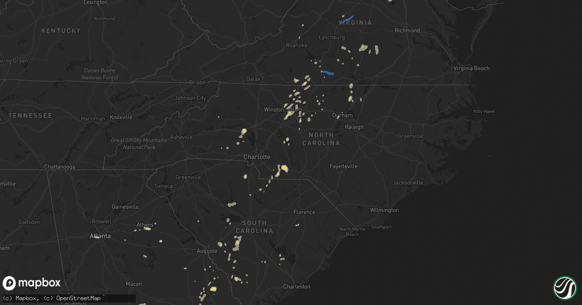
Hail Map in North Carolina on July 9, 2025
Get this storm
July 9 map
$229
one time, instant access
Download today. No call, no setup
Keep the $229
Bought the map and want the full workflow? Apply the entire $229 to a subscription within 7 days. None of it is wasted.
Every map, not just this one
This buys you this map. Subscription and you get every map we run, in the markets you choose from a few cities to whole states to nationwide. Plus real-time alerts the moment a storm fires.
Contact data
Name, contact info, occupancy, even credit band for addresses in the footprint. You go from where it hit to who to call.
Become the source they trust
Unlimited branding weather history reports on demand. You already have the documented answer ready for the property owner, and you are the one who showed up with it.
Property data and RoofTrace estimates
Pull up any address you have got, its value and the exact code rules for that jurisdiction, straight from One Click Code. Then RoofTrace estimates the squares, pitch, and roof value, priced the way you price.
Storm reports in North Carolina
North Carolina
| Date | Description |
|---|---|
| 07/09/20256:58 PM CDT | Multiple trees and power lines down across central lincoln county. |
| 07/09/20256:57 PM CDT | Tree down at hwy 902 and the rocky river bridge. Radar estimated time. |
| 07/09/20256:45 PM CDT | 911 center reports several trees down around siler city. |
| 07/09/20256:22 PM CDT | Tree down blocking both lanes. |
| 07/09/20256:20 PM CDT | Tree down on lineberger road. |
| 07/09/20256:15 PM CDT | Power line down on 5th avenue southwest. |
| 07/09/20256:00 PM CDT | Trees down on braxton drive. |
| 07/09/20255:54 PM CDT | Trees down on power equipment. |
| 07/09/20255:53 PM CDT | Tree blocking the road at smith farm road and highway 90. |
| 07/09/20255:51 PM CDT | Tree down on emmanuel church road. |
| 07/09/20255:48 PM CDT | Power lines down near i-40 and stamey farm road. |
| 07/09/20255:46 PM CDT | Tree in road way on buffalo ford rd & grantville ln. |
| 07/09/20255:46 PM CDT | Tree down on power equipment. |
| 07/09/20255:45 PM CDT | Tree down on us highway 70 east. |
| 07/09/20255:43 PM CDT | Tree down on riverbend road. |
| 07/09/20255:42 PM CDT | Tree down near commonwealth rd & walker mill rd in sophia... Nc. |
| 07/09/20255:37 PM CDT | Tree down on power equipment. |
| 07/09/20255:37 PM CDT | Tree down near henderson grove church road and jacob bost road. |
| 07/09/20255:28 PM CDT | Trees down on powerlines. |
| 07/09/20255:20 PM CDT | Tree down on airport road. |
| 07/09/20255:18 PM CDT | Tree down on shiptontown rd. |
| 07/09/20255:12 PM CDT | Tree down on power equipment. |
| 07/09/20255:08 PM CDT | Tree on house and car off jackson hill rd... Denton. |
| 07/09/20255:04 PM CDT | Tree down on power equipment. |
| 07/09/20254:56 PM CDT | Tree down on tuckertown rd. |
| 07/09/20254:35 PM CDT | Trees down across the roadway. |
| 07/09/20254:27 PM CDT | Trees down with damage to power poles near the courthouse. |
| 07/09/20254:25 PM CDT | Several power poles broken. |
| 07/09/20254:24 PM CDT | Tree down on bethal church rd. |
| 07/09/20254:21 PM CDT | Trees down in wadesboro. |
| 07/09/20254:18 PM CDT | Trees down in peachland... Nc. |
| 07/09/20254:11 PM CDT | Tree down near belews creek rd. |
| 07/09/20254:11 PM CDT | Multiple trees down on witty rd. |
| 07/09/20254:07 PM CDT | Tree down near landsford road and white store road. |
| 07/09/20254:00 PM CDT | Tree down on vance road. |
| 07/09/20253:58 PM CDT | Tree down near lanes creek rd. |
| 07/09/20253:54 PM CDT | Thunderstorm winds blew down one tree along the 2600 block of whitaker road. |
| 07/09/20253:05 PM CDT | Thunderstorm winds blew down multiple trees near the intersection of roberts rock road and lime rock road. |
| 07/09/20252:43 PM CDT | Thunderstorm winds blew down one tree near the intersection of interstate 77 and us route 21 bypass. |
| 07/09/20252:17 PM CDT | Tree down near kincaid southwest circle and southwest boulevard. |
| 07/09/20252:17 PM CDT | Thunderstorm winds blew down one tree near the intersection of grassy fork road and beaver road. |
| 07/09/20252:10 PM CDT | Thunderstorm winds blew down one tree near the intersection of thurmond road and zephyr mountain park road. |
| 07/09/20251:59 PM CDT | Thunderstorm winds blew down one tree near the intersection of traphill road and traphill union road. |
| 07/09/20251:54 PM CDT | Tree down on brown mountain beach road. |
| 07/09/20251:43 PM CDT | A local report indicates 1.00 inch wind near 1 WSW Halls Mills |
| 07/09/20251:07 PM CDT | Trees down along highway 16. Road bloc |
| 07/09/20251:07 PM CDT | Trees down along highway 16. Road blocked. |
| 07/09/20259:05 AM CDT | Several trees down near and west of halifax. |
| 07/09/20257:04 AM CDT | Tree down on power equipment near hanks street. |
| 07/08/202511:40 PM CDT | Crabtree creek crested in flood stage at the wake forest gage with a reading of 12.6 feet at 1240 am flooding nearby areas. |
| 07/08/202511:05 PM CDT | Walnut creek crested in flood stage at the trailwood drive gage with a reading of 10.5 feet at 1205 am flooding nearby areas and roads. |
| 07/08/20259:13 PM CDT | Tree down at roanoke ave and harriet st. |
| 07/08/20258:00 PM CDT | Tree down on power equipment near glasscock street. |
| 07/08/20257:57 PM CDT | Tree down at western blvd near nazareth st... Resulting in power outages. |
| 07/08/20257:57 PM CDT | Tree down resulting in power outages on western blvd near nazareth st. |
| 07/08/20257:18 PM CDT | Tree down at old us 421 and foust rd. Radar estimated time. |
| 07/08/20257:16 PM CDT | Tree down at chapel hill rd and pinecrest rd... Resulting in power outages. |
| 07/08/20257:15 PM CDT | Tree down at old chapel hill rd near mohawk trail... Resulting in power outages. |
| 07/08/20257:15 PM CDT | Tree down at old chapel hill rd and mohawk trail... Resulting in power outages. |
| 07/08/20257:04 PM CDT | Corrects previous tstm wnd dmg report from pittsboro. Tree down on power equipment near hanks street. |
| 07/08/20257:03 PM CDT | Corrects previous tstm wnd dmg report from pittsboro. Tree down on power equipment near hanks st. |
| 07/08/20257:03 PM CDT | Corrects previous tstm wnd dmg report from pittsboro. Tree down on power equipment near hanks drive. |
All States Impacted by Hail Map on July 9, 2025
Cities Impacted by Hail Map on July 9, 2025
- Comanche, TX
- Newburg, ND
- Balfour, ND
- Saint Edward, NE
- Alapaha, GA
- Pullman, WV
- West Union, WV
- Berea, WV
- Auburn, WV
- New Milton, WV
- Harrisville, WV
- Pennsboro, WV
- Willacoochee, GA
- Ambrose, GA
- Whitesburg, KY
- Rochelle, GA
- Weston, WV
- Camden, WV
- Douglas, GA
- Hawkinsville, GA
- Pearson, GA
- Axson, GA
- Ermine, KY
- Nicholls, GA
- Abbeville, GA
- Roanoke, VA
- Pineview, GA
- Eastman, GA
- Troutville, VA
- Broxton, GA
- Gassaway, WV
- Cedarville, WV
- Exchange, WV
- Camilla, GA
- Cadwell, GA
- Waycross, GA
- Denton, GA
- Hazlehurst, GA
- Tarrytown, GA
- Cochran, GA
- Eagle Rock, VA
- Gable, SC
- Rhine, GA
- Ailey, GA
- Burnsville, WV
- Olanta, SC
- Milan, GA
- Flatwoods, WV
- Keysville, GA
- Waynesboro, GA
- Vidalia, GA
- Stapleton, GA
- Avera, GA
- Louisville, GA
- Eutawville, SC
- Napier, WV
- Walkersville, WV
- Heaters, WV
- Ireland, WV
- Alamo, GA
- McRae Helena, GA
- Jacksonville, GA
- Dorchester, SC
- Scranton, SC
- Collettsville, NC
- Lyons, GA
- Metter, GA
- Lumber City, GA
- Guyton, GA
- Rincon, GA
- Cross, SC
- Twin City, GA
- Mount Vernon, GA
- Uvalda, GA
- Glenwood, GA
- Holly Hill, SC
- Millen, GA
- Buffalo, SD
- Soperton, GA
- Garfield, GA
- Aiken, SC
- Lovingston, VA
- Denver City, TX
- Greenville, MI
- Sandy Level, VA
- Bowman, SC
- Reevesville, SC
- Saint George, SC
- Lehigh Acres, FL
- Branchville, SC
- Sardis, GA
- Windsor, SC
- Martinsville, VA
- Claxton, GA
- Fort Stewart, GA
- Rocky Ford, GA
- Sylvania, GA
- Ponce De Leon, FL
- Tampa, FL
- Belding, MI
- Rockford, MI
- Barnwell, SC
- Butler, GA
- Harbor Beach, MI
- Leesville, SC
- Okeechobee, FL
- Cape Coral, FL
- Arrington, VA
- Shipman, VA
- Schuyler, VA
- Wingina, VA
- Junction City, GA
- Pittsville, VA
- Vero Beach, FL
- Statesboro, GA
- Ruth, MI
- Wagener, SC
- Spencer, VA
- Corrigan, TX
- Moscow, TX
- Williston, SC
- Esmont, VA
- Ridgeway, VA
- Salley, SC
- Fairfax, SC
- Brunson, SC
- Prairie City, SD
- Springfield, SC
- Sanford, FL
- Lake Mary, FL
- Reva, SD
- Lodgepole, SD
- Penhook, VA
- Midville, GA
- Walnut Cove, NC
- Madison, NC
- Mayodan, NC
- Gretna, VA
- Chatham, VA
- Live Oak, FL
- Pelion, SC
- Batesburg, SC
- Lancaster, SC
- Heath Springs, SC
- Neeses, SC
- Pageland, SC
- Monroe, NC
- Winston Salem, NC
- Lemmon, SD
- Hettinger, ND
- Axton, VA
- Pine Hall, NC
- Walkertown, NC
- Mousie, KY
- Concord, VA
- North Fort Myers, FL
- Geneva, FL
- Marshville, NC
- Wingate, NC
- Clermont, FL
- Pine Ridge, SD
- Fairburn, SD
- Union Grove, NC
- Wayland, KY
- Raven, KY
- Red House, VA
- Mott, ND
- Allendale, SC
- Peachland, NC
- Polkton, NC
- Midland, VA
- Warrenton, VA
- Punta Gorda, FL
- Winter Garden, FL
- Kissimmee, FL
- Oviedo, FL
- Swansea, SC
- North, SC
- Blairs, VA
- Keeling, VA
- Vernon Hill, VA
- Orlando, FL
- Winnsboro, SC
- Great Falls, SC
- Remington, VA
- Bealeton, VA
- Bumpass, VA
- Spotsylvania, VA
- Mineral, VA
- Belews Creek, NC
- Newberry, SC
- Prosperity, SC
- Pomaria, SC
- Blair, SC
- Wounded Knee, SD
- Farmville, VA
- Keysville, VA
- Harmony, NC
- Catlett, VA
- Davenport, FL
- Stoneville, NC
- Java, VA
- South Boston, VA
- Appomattox, VA
- Brookneal, VA
- Stokesdale, NC
- Summerfield, NC
- Hampden Sydney, VA
- Nathalie, VA
- Conestoga, PA
- Millersville, PA
- Washington Boro, PA
- Eden, NC
- Bison, SD
- Meadow, SD
- Kernersville, NC
- Minden City, MI
- Albertville, AL
- Manderson, SD
- Porcupine, SD
- Bradley, SC
- Elkwood, VA
- Avon Park, FL
- Reidsville, NC
- Windermere, FL
- Meherrin, VA
- Green Bay, VA
- New London, NC
- Richfield, NC
- Crossville, AL
- Boaz, AL
- Cascade, VA
- Wrightsville, PA
- Oak Ridge, NC
- Denton, NC
- Wanblee, SD
- Allen, SD
- Kyle, SD
- Greensboro, NC
- Martin, SD
- Phenix, VA
- Charlotte Court House, VA
- Crewe, VA
- Polk City, FL
- Okatie, SC
- Bluffton, SC
- Arcadia, FL
- Felton, PA
- Lancaster, PA
- Rice, VA
- Wadesboro, NC
- Batesland, SD
- Mud Butte, SD
- Faith, SD
- Hampton, SC
- Varnville, SC
- Claremont, NC
- Rock Hill, SC
- High Point, NC
- Lexington, NC
- Catawba, NC
- Newton, NC
- Conover, NC
- Willow Street, PA
- Clifton, TX
- Asheboro, NC
- Sophia, NC
- Drakes Branch, VA
- Saxe, VA
- New Leipzig, ND
- Elon, NC
- Union Point, GA
- Randleman, NC
- Colfax, NC
- Burkeville, VA
- Thomasville, NC
- Red Lion, PA
- Browns Summit, NC
- Brogue, PA
- Stewartstown, PA
- Halifax, VA
- Long Valley, SD
- Norris, SD
- Burlington, NC
- Alto, TX
- Airville, PA
- Oxford, NC
- Nelson, VA
- Virgilina, VA
- Bullock, NC
- Tuthill, SD
- Dupree, SD
- Lantry, SD
- Eagle Butte, SD
- Newell, SD
- Stem, NC
- New Park, PA
- Liberty, NC
- Anniston, AL
- Gordon, NE
- Ona, FL
- McLaughlin, SD
- Timber Lake, SD
- Isabel, SD
- Belle Fourche, SD
- Mebane, NC
- Haw River, NC
- Julian, NC
- Climax, NC
- Whitsett, NC
- Chester, SC
- Maiden, NC
- Pequea, PA
- Rougemont, NC
- Trail City, SD
- Glencross, SD
- Whitehorse, SD
- Wakpala, SD
- Roundup, MT
- Graham, NC
- Lincolnton, NC
- Malone, TX
- Elgin, ND
- Glen Ullin, ND
- Bynum, TX
- Merriman, NE
- Wilton, ND
- Taylor, ND
- Gladstone, ND
- Richardton, ND
- Shelby, NC
- Lawndale, NC
- Strasburg, PA
- Baldwin, ND
- Regan, ND
- Clyde, OH
- Atlanta, GA
- Menoken, ND
- Sterling, ND
- Presho, SD
- Llano, TX
- Hague, VA
- Mcclusky, ND
- Mobridge, SD
- Selby, SD
- Glenham, SD
- Gettysburg, SD
- Akaska, SD
- Pierre, SD
- Agar, SD
- Onida, SD
- Hoven, SD
- Java, SD
- Bowdle, SD
- Eureka, SD
- Mound City, SD
- Bismarck, ND
- Hillsboro, TX
- Saint Francis, SD
- Kilgore, NE
- Crookston, NE
- Mission, SD
- Sparks, NE
- Springview, NE
- Valentine, NE
- Mullen, NE
- Thedford, NE
- Johnstown, NE
- Wood Lake, NE
- Seneca, NE
- Parmelee, SD
- Mandan, ND
- Okreek, SD
- Wood, SD
- White River, SD
- Winner, SD
- Witten, SD
- Rosebud, SD
- Vickery, OH
- Kennebec, SD
- Orange, VA
- Louisa, VA
- Elsmere, NE
- Ainsworth, NE
- Long Pine, NE
- Colbert, GA
- Crawford, GA
- Athens, GA
- North Port, FL
- Kershaw, SC
- Brandy Station, VA
- Harrold, SD
- Blunt, SD
- Fort Pierre, SD
- Lebanon, SD
- Holabird, SD
- Highmore, SD
- Lower Brule, SD
- Tolstoy, SD
- Hosmer, SD
- Ree Heights, SD
- Onaka, SD
- Orient, SD
- Roscoe, SD
- Stephan, SD
- Seneca, SD
- Fort Thompson, SD
- Miller, SD
- Faulkton, SD
- Saint Lawrence, SD
- Ipswich, SD
- Rockham, SD
- Cresbard, SD
- Tulare, SD
- Northville, SD
- Mansfield, SD
- Westport, SD
- Leola, SD
- Kulm, ND
- Fredonia, ND
- Forbes, ND
- Long Lake, SD
- Ellendale, ND
- Ashley, ND
- Edgeley, ND
- Frederick, SD
- Gackle, ND
- Lehr, ND
- Jud, ND
- Wishek, ND
- Streeter, ND
- Medina, ND
- Tappen, ND
- Napoleon, ND
- Dawson, ND
- Steele, ND
- Zeeland, ND
- Linton, ND
- Braddock, ND
- Kintyre, ND
- Driscoll, ND
- York, ND
- Burke, SD
- Wing, ND
- Herreid, SD
- Hague, ND
- Pollock, SD
- Robinson, ND
- Kinsale, VA
- Marco Island, FL
- Covington, GA
- Jacksonville, TX
- Leeds, ND
- Strasburg, ND
- Monroe, GA
- Sheyenne, ND
- Stapleton, NE
- Reliance, SD
- Henderson, NC
- Oxford, GA
- Harvey, ND
- Maddock, ND
- Lancaster, MN
- Oberon, ND
- Arnold, NE
- Watkinsville, GA
- Cleveland, ND
- Jamestown, ND
- Winterville, GA
- Callaway, NE
- Jefferson, TX
- Tolna, ND
- New Rockford, ND
- Goodland, FL
- Saint Michael, ND
- Warwick, ND
- Arnoldsville, GA
- Junction, TX
- Lynch, NE
- Ennis, TX
- Gann Valley, SD
- Kimball, SD
- Wessington, SD
- Wessington Springs, SD
- Alpena, SD
- Letcher, SD
- Plankinton, SD
- Woonsocket, SD
- Virgil, SD
- Wolsey, SD
- Fulton, SD
- Mitchell, SD
- Artesian, SD
- Carthage, SD
- Huron, SD
- De Smet, SD
- Hitchcock, SD
- Yale, SD
- Cavour, SD
- Fedora, SD
- Iroquois, SD
- Redfield, SD
- Page, NE
- Avon, SD
- Ewing, NE
- Orchard, NE
- Brady, NE
- Fort Myers, FL
- Blooming Grove, TX
- Verdigre, NE
- Oconto, NE
- Ringgold, VA
- Danville, VA
- Strandquist, MN
- Clearwater, NE
- Rice, TX
- Gothenburg, NE
- Barry, TX
- Creighton, NE
- Winnetoon, NE
- Petersburg, NE
- Elgin, NE
- Chambers, NE
- Italy, TX
- Center, NE
- Scotland, SD
- Delmont, SD
- Armour, SD
- Tripp, SD
- Parkston, SD
- Olivet, SD
- Cozad, NE
- Cathay, ND
- Yanceyville, NC
- Durham, NC
- Ashton, SD
- Midland, SD
- Tabor, SD
- Karlstad, MN
- Philip, SD
- Kadoka, SD
- Bloomfield, NE
- Wausa, NE
- Albion, NE
- Greenbush, MN
- Bartlett, NE
- Chapel Hill, NC
- Platte, SD
- Geddes, SD
- Harrison, SD
- Corsica, SD
- Wagner, SD
- Lake Andes, SD
- Dante, SD
- Tyndall, SD
- Kaylor, SD
- New Holland, SD
- Lesterville, SD
- Menno, SD
- Colome, SD
- Ideal, SD
- Canova, SD
- Alexandria, SD
- Howard, SD
- Spencer, SD
- Winfred, SD
- Oldham, SD
- Salem, SD
- Strathcona, MN
- Newfolden, MN
- Neligh, NE
- Fordyce, NE
- Hartington, NE
- Okaton, SD
- Battle Creek, NE
- Meadow Grove, NE
- Pierce, NE
- Belvidere, SD
- Scotia, NE
- Osmond, NE
- Mclean, NE
- Viking, MN
- Warren, MN
- Bishop, GA
- Ramona, SD
- Lake Preston, SD
- Madison, SD
- Union Center, SD
- Lexington, NE
- Murdo, SD
- Randolph, NE
- Wynot, NE
- Marion, SD
- Bridgewater, SD
- Belden, NE
- The Colony, TX
- Carrollton, TX
- Tilden, NE
- Montrose, SD
- Colton, SD
- Humboldt, SD
- Hartford, SD
- Canistota, SD
- Wentworth, SD
- Chester, SD
- Palmer, NE
- Wolbach, NE
- Humphrey, NE
- Winside, NE
- Draper, SD
- Vivian, SD
- Amherst, NE
- Laurel, NE
- Monroe, SD
- Milford, DE
- Carroll, NE
- Wayne, NE
- Platte Center, NE
- Monroe, NE
- Ravenna, NE
- Grand Island, NE
- Cairo, NE
- Wood River, NE
- Alda, NE
- Shelton, NE
- Pleasanton, NE
- Gibbon, NE
- Riverdale, NE
- Miller, NE
- Kearney, NE
- Thief River Falls, MN
- Fisher, MN
- East Grand Forks, MN
- Euclid, MN
- Creston, NE
- Parker, SD
- Stromsburg, NE
- Clarks, NE
- Grace City, ND
- Leigh, NE
- Columbus, NE
- Kenesaw, NE
- Polk, NE
- Wakefield, NE
- Minden, NE
- Juniata, NE
- Doniphan, NE
- Roseland, NE
- Hastings, NE
- Giltner, NE
- Trumbull, NE
- Henderson, NE
- Harvard, NE
- Aurora, NE
- Phillips, NE
- Hampton, NE
- Schuyler, NE
- Buxton, ND
- Marquette, NE
- Bradshaw, NE
- Hordville, NE
- Pender, NE
- Thurston, NE
- Elk Point, SD
- Westfield, IA
- Eatonton, GA
- Emerson, NE
- Shelby, NE
- Bellwood, NE
- Clarkson, NE
- Osceola, NE
- Andalusia, AL
- Sioux Falls, SD
- Winnebago, NE
- Homer, NE
- West Point, NE
- Marcus, IA
- Rising City, NE
- Rogers, NE
- Quimby, IA
- Cherokee, IA
- Cleghorn, IA
- Dakota City, NE
- Hubbard, NE
- Cushing, IA
- Holstein, IA
- Correctionville, IA
- Gresham, NE
- Dodge, NE
- Benedict, NE
- Larchwood, IA
- North Bend, NE
- Morse Bluff, NE
- Linwood, NE
- York, NE
- David City, NE
- Rosalie, NE
- Bancroft, NE
- Waco, NE
- Dell Rapids, SD
- Sutton, NE
- Inland, NE
- Glenvil, NE
- Ayr, NE
- Meriden, IA
- Magnolia, MN
- Saronville, NE
- Prague, NE
- Bruno, NE
- Brainard, NE
- Oakland, NE
- Scribner, NE
- Hooper, NE
- Macy, NE
- Walthill, NE
- Hills, MN
- Sloan, IA
- Washta, IA
- Utica, NE
- Neola, IA
- Persia, IA
- Malmo, NE
- Colon, NE
- McCool Junction, NE
- Adrian, MN
- Lismore, MN
- Onawa, IA
- Reading, MN
- Whiting, IA
- Uehling, NE
- Ute, IA
- Mapleton, IA
- Decatur, NE
- Bennington, NE
- Omaha, NE
- Battle Creek, IA
- Staplehurst, NE
- Luverne, MN
- Wahoo, NE
- Weston, NE
- Tekamah, NE
- Cedar Bluffs, NE
- Kenneth, MN
- Comstock, NE
- Elkhorn, NE
- Fairmont, NE
- Exeter, NE
- Shickley, NE
- Valparaiso, NE
- Gary, MN
- Ellsworth, MN
- Rock Rapids, IA
- Morris, MN
- Fertile, MN
- Ceresco, NE
- Geneva, NE
- Worthington, MN
- Ong, NE
- Edgar, NE
- Milford, NE
- Seward, NE
- Grafton, NE
- Ithaca, NE
- Hornick, IA
- Valley, NE
- Modale, IA
- Paullina, IA
- Sibley, IA
- Granville, IA
- Underwood, IA
- Sanborn, IA
- Charter Oak, IA
- Clare, IA
- Humboldt, IA
- Gretna, NE
- Friend, NE
- Milligan, NE
- Cylinder, IA
- Waterloo, NE
- Kennard, NE
- Missouri Valley, IA
- Bigelow, MN
- Davey, NE
- Raymond, NE
- Waverly, NE
- Ashton, IA
- Melvin, IA
- Carleton, NE
- Davenport, NE
- Windom, MN
- Glenwood, IA
- Bellevue, NE
- Council Bluffs, IA
- Lamberton, MN
- Wabasso, MN
- Springfield, NE
- Wilber, NE
- Western, NE
- Swanton, NE
- Hoffman, MN
- Heron Lake, MN
- Tobias, NE
- Greenwood, NE
- Ashland, NE
- Papillion, NE
- Minden, IA
- Boys Town, NE
- Ocheyedan, IA
- Harris, IA
- Alexandria, NE
- Bruning, NE
- Bassett, NE
- Hartley, IA
- Kensington, MN
- Kiron, IA
- Odebolt, IA
- Jansen, NE
- Plymouth, NE
- McClelland, IA
- Barrett, MN
- Hebron, NE
- Deshler, NE
- Arthur, IA
- Clatonia, NE
- Louisville, NE
- Plattsmouth, NE
- Silver City, IA
- Malvern, IA
- Milford, IA
- Treynor, IA
- Hallam, NE
- Schaller, IA
- Everly, IA
- Weeping Water, NE
- Cedar Creek, NE
- La Vista, NE
- Eagle Grove, IA
- Union, NE
- Spirit Lake, IA
- Denison, IA
- Vail, IA
- Taylor, NE
- De Witt, NE
- Spencer, IA
- Jackson, MN
- Lakefield, MN
- Hastings, IA
- Henderson, IA
- Dunbar, NE
- Murray, NE
- Alpha, MN
- Sleepy Eye, MN
- Oakland, IA
- Breda, IA
- Arcadia, IA
- Westside, IA
- Graettinger, IA
- Emmetsburg, IA
- Big Falls, MN
- Emerson, IA
- Pacific Junction, IA
- Beatrice, NE
- Dunnell, MN
- Menahga, MN
- Ayrshire, IA
- Curlew, IA
- Estherville, IA
- Nebraska City, NE
- Burwell, NE
- Malcolm, NE
- Lincoln, NE
- Pleasant Dale, NE
- Walton, NE
- Truman, MN
- Parkers Prairie, MN
- Welcome, MN
- Loman, MN
- New York Mills, MN
- Sebeka, MN
- Wadena, MN
- Bluffton, MN
- Ruthven, IA
- Rockwell City, IA
- Bennet, NE
- Offutt Afb, NE
- Mineola, IA
- Red Oak, IA
- Stanton, IA
- Johnson, NE
- Granada, MN
- Mallard, IA
- Saint James, MN
- Fairmont, MN
- Loup City, NE
- Woolstock, IA
- Henry, SD
- Watertown, SD
- Amelia, NE
- Litchfield, NE
- Winnebago, MN
- Clearfield, IA
- Verndale, MN
- Webster City, IA
- Essex, IA
- Algona, IA
- Park Rapids, MN
- Kelliher, MN
- Blackduck, MN
- Auburn, NE
- Hazard, NE
- Titonka, IA
- Lakota, IA
- Buffalo Center, IA
- Arcadia, NE
- Ord, NE
- Staples, MN
- Newport, NE
- Frost, MN
- Blue Earth, MN
- Garner, IA
- Kanawha, IA
- Goodell, IA
- Bricelyn, MN
- Thompson, IA
- Rake, IA
- Klemme, IA
- Mirando City, TX
- Bruni, TX
- Diagonal, IA
- Deer River, MN
- Hackensack, MN
- Backus, MN
- Blairsburg, IA
- Ackley, IA
- Longville, MN
- Rockville, NE
- Pine River, MN
- Wellsburg, IA
- Holstein, NE
- Hampton, IA
- Sheffield, IA
- Latimer, IA
- Dumont, IA
- Ashton, NE
- Boelus, NE
- Aplington, IA
- Aredale, IA
- Allison, IA
- Parkersburg, IA
- Geneva, IA
- Blue Hill, NE
- Waterloo, IA
- La Porte City, IA
- Guide Rock, NE
- Mankato, KS
- Burr Oak, KS
- Jesup, IA
- Gilbertville, IA
- Evansdale, IA
- Independence, IA
- Mount Auburn, IA
- Brandon, IA
- Hamill, SD


