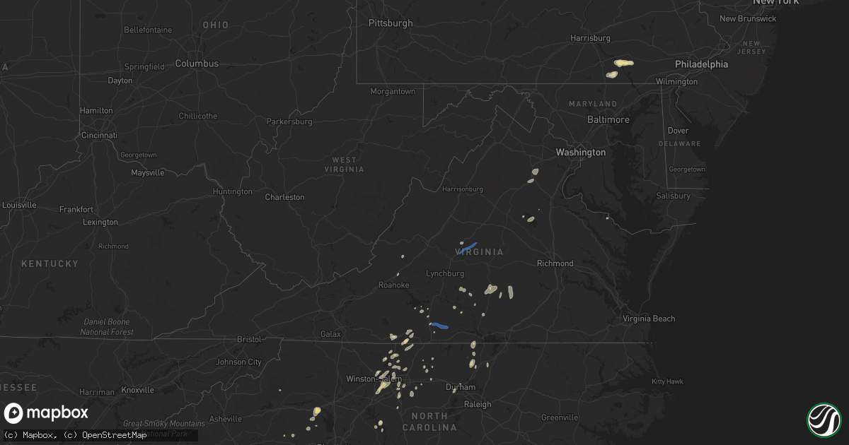
Hail Map in Virginia on July 9, 2025
Get this storm
July 9 map
$229
one time, instant access
Download today. No call, no setup
Keep the $229
Bought the map and want the full workflow? Apply the entire $229 to a subscription within 7 days. None of it is wasted.
Every map, not just this one
This buys you this map. Subscription and you get every map we run, in the markets you choose from a few cities to whole states to nationwide. Plus real-time alerts the moment a storm fires.
Contact data
Name, contact info, occupancy, even credit band for addresses in the footprint. You go from where it hit to who to call.
Become the source they trust
Unlimited branding weather history reports on demand. You already have the documented answer ready for the property owner, and you are the one who showed up with it.
Property data and RoofTrace estimates
Pull up any address you have got, its value and the exact code rules for that jurisdiction, straight from One Click Code. Then RoofTrace estimates the squares, pitch, and roof value, priced the way you price.
Storm reports in Virginia
Virginia
| Date | Description |
|---|---|
| 07/09/20256:23 PM CDT | Tree reported down at the intersection of oak row rd. And rosehill drive. Radar estimated time. |
| 07/09/20256:20 PM CDT | Reports of multiple trees down near the intersection of yorkers swamp rd. And colnbrook rd. Radar estimated time. |
| 07/09/20256:18 PM CDT | Tree down near the intersection of tidewater trail and berry hill road. Radar estimated time. |
| 07/09/20256:13 PM CDT | A tree fell along king william rd. |
| 07/09/20256:10 PM CDT | A tree fell down across namozine rd. |
| 07/09/20256:10 PM CDT | A tree fell down at the intersection of club commons rd and old wyndham dr. |
| 07/09/20256:08 PM CDT | A tree fell on a house on chayton ln. No injuries were reported. Radar estimated time. |
| 07/09/20255:55 PM CDT | A tree fell along hermitage rd. |
| 07/09/20255:50 PM CDT | Tree reported down at the intersection of lewiston plank rd. And old school house rd. Time estimated from radar. |
| 07/09/20255:36 PM CDT | A tree fell down along river road west. |
| 07/09/20255:36 PM CDT | Tree reported down at the 2800 block of bible rd. Time estimated from radar. |
| 07/09/20255:36 PM CDT | A tree fell down along dykeland rd. |
| 07/09/20255:35 PM CDT | A tree fell at the intersection of liberty fork rd and beverly run rd. |
| 07/09/20255:35 PM CDT | A tree fell across liberty fork rd. |
| 07/09/20255:34 PM CDT | Power line down in crewe with power outages. Time estimated from radar. |
| 07/09/20255:31 PM CDT | Tree damage was reported on saint james rd. Radar estimated time. |
| 07/09/20255:30 PM CDT | Tree damage reported on meade rd. Radar estimated time. |
| 07/09/20255:30 PM CDT | A tree fell down at the intersection of three bridge rd and maidens rd. |
| 07/09/20255:27 PM CDT | Tree down at intersection of russell road and w myrtle street... Blocking both lanes. |
| 07/09/20255:27 PM CDT | Tree down at mathias point rd and bundock rd |
| 07/09/20255:27 PM CDT | Tree down in the 200 block of n payne street... Blocking both lanes. |
| 07/09/20255:26 PM CDT | Tree down at the intersection of duke st and cambridge rd... Blocking one lane. |
| 07/09/20255:26 PM CDT | Tree down in the 4800 block of arlington blvd. |
| 07/09/20255:24 PM CDT | Thunderstorm winds blew down one tree along green rock hills lane. |
| 07/09/20255:21 PM CDT | Thunderstorm winds blew down one tree along the 1200 block of barnesville highway. |
| 07/09/20255:21 PM CDT | Thunderstorm winds blew down one tree near the 300 block of union cemetery road. |
| 07/09/20255:21 PM CDT | Thunderstorm winds blew down one tree near the 300 block of welsh tract road. |
| 07/09/20255:19 PM CDT | Tree down on car along melon road. |
| 07/09/20255:17 PM CDT | Tree down near indiantown rd and kings hwy |
| 07/09/20255:15 PM CDT | Tree fell on power line. |
| 07/09/20255:15 PM CDT | Reports of a few trees down in mount vernon. |
| 07/09/20255:14 PM CDT | A tree fell down along clement town rd. |
| 07/09/20255:14 PM CDT | A tree fell down at the intersection of clementown rd and old buckingham rd. |
| 07/09/20255:10 PM CDT | A tree fell along ballsville rd. |
| 07/09/20255:10 PM CDT | Tree fell onto house. Power lines also down. |
| 07/09/20255:00 PM CDT | Tree down. |
| 07/09/20255:00 PM CDT | Tree down... Completely blocking road. |
| 07/09/20254:53 PM CDT | Reports of a few trees down in clifton. |
| 07/09/20254:53 PM CDT | Trees onto powerlines at 15034 alabama ave |
| 07/09/20254:52 PM CDT | Tree on power line. |
| 07/09/20254:49 PM CDT | Numerous trees down across the city of stafford. |
| 07/09/20254:49 PM CDT | Tree down. Blocking both lanes near intersection of halifax and coleman mountain rd. |
| 07/09/20254:42 PM CDT | Tree down on curdsville road. |
| 07/09/20254:42 PM CDT | Thunderstorm winds blew down one tree near the intersection of old curdsville road and bishop creek road and buckingham springs road. |
| 07/09/20254:42 PM CDT | Tree down at delaney rd and minnieville rd |
| 07/09/20254:42 PM CDT | Reported by public. |
| 07/09/20254:40 PM CDT | Tree down on bragg street. Radar estimated time. |
| 07/09/20254:37 PM CDT | Thunderstorm winds blew down one tree near the intersection of rolling hill road and price road. |
| 07/09/20254:34 PM CDT | Thunderstorm winds blew down one tree along the 6700 block of axton road. |
| 07/09/20254:32 PM CDT | Tree down on worsham rd. Radar estimated time. |
| 07/09/20254:30 PM CDT | Tree down at the intersection of sillamon rd. And backwell mills rd. |
| 07/09/20254:27 PM CDT | Thunderstorm winds blew down one tree on bear creek road. |
| 07/09/20254:26 PM CDT | Tree down at the intersection of howard trail. And river rd. |
| 07/09/20254:25 PM CDT | Multiple trees down near old church rd and slate run ln |
| 07/09/20254:24 PM CDT | Thunderstorm winds blew down one tree near the intersection of route 460 and hixburg road. |
| 07/09/20254:22 PM CDT | Thunderstorm winds blew down one tree along the 2200 block of red house road. |
| 07/09/20254:22 PM CDT | Thunderstorm winds blew down one tree along the 2200 block of red house |
| 07/09/20254:19 PM CDT | Tree across road. |
| 07/09/20254:17 PM CDT | Tree down on hall road. |
| 07/09/20254:17 PM CDT | Tree down across powerline. |
| 07/09/20254:15 PM CDT | Tree limb across power line. Power is out. |
| 07/09/20254:15 PM CDT | Tree down on road near intersection of central church rd and promise land rd. |
| 07/09/20254:12 PM CDT | Tree down at the intersection of oak mill rd. And clifton ln. |
| 07/09/20254:10 PM CDT | Tree on power line. |
| 07/09/20254:10 PM CDT | Thunderstorm winds blew down one tree near the intersection of central church road and warren lane. |
| 07/09/20254:10 PM CDT | Multiple trees and large branches down at 6975 courthouse... Va. This is at the spotsylvania high school. |
| 07/09/20254:09 PM CDT | Thunderstorm winds blew down one tree along the 2600 block of promise land road. |
| 07/09/20254:07 PM CDT | Tree down at the intersection of post oak rd. And curtis ln. |
| 07/09/20254:01 PM CDT | Tree down. Blocking most of road. |
| 07/09/20254:00 PM CDT | Tree across power line. |
| 07/09/20254:00 PM CDT | Tree across road. |
| 07/09/20254:00 PM CDT | Tree down resulting in power outages. |
| 07/09/20253:56 PM CDT | Tree fell on power line. |
| 07/09/20253:56 PM CDT | Tree down... Blocking 1 lane of william f |
| 07/09/20253:56 PM CDT | Tree down... Blocking 1 lane of william f stone hwy. |
| 07/09/20253:55 PM CDT | Tree fell on top of a house and came through roof...visible inside of house. |
| 07/09/20253:50 PM CDT | A tree fell along three chopt rd. |
| 07/09/20253:50 PM CDT | Tree down on power line. Near entrance to rich acres school. |
| 07/09/20253:50 PM CDT | Tree down across power lines and blocking highway... Along fishers farm road and oxford drive. |
| 07/09/20253:50 PM CDT | Tree fell on house. Came through into kitchen and bathroom. |
| 07/09/20253:48 PM CDT | Thunderstorm winds blew down one tree on route 58 bypass and route 220 just north of the joseph martin highway exit. |
| 07/09/20253:46 PM CDT | Tree down in the 100 block of lakeview dr. |
| 07/09/20253:40 PM CDT | Tree down. Traffic light out. |
| 07/09/20253:37 PM CDT | Large tree down near intersection of zachary taylor hwy and grasty ln |
| 07/09/20253:31 PM CDT | Two trees reported down in stanley on us-340 and keystone road. |
| 07/09/20253:30 PM CDT | Tree down... Blocking one lane of old mtn rd. |
| 07/09/20253:29 PM CDT | Thunderstorm winds blew down one tree near the intersection of machinery drive and business route 58. |
| 07/09/20253:24 PM CDT | Thunderstorm winds blew down one tree along the 1900 block of stultz road. |
| 07/09/20253:24 PM CDT | Thunderstorm winds blew down one tree on to koehler road. |
| 07/09/20253:22 PM CDT | Tree down on eagle mountain drive. |
| 07/09/20253:17 PM CDT | Tree down across the 7000 block of courthouse road |
| 07/09/20253:05 PM CDT | Thunderstorm winds blew down one tree on to the 100 block of anstey road. |
| 07/09/20253:00 PM CDT | Tree down near colonial highway. |
| 07/09/20252:52 PM CDT | Thunderstorm winds blew down one tree near the intersection of oak level road and edgewood drive. |
| 07/09/20252:50 PM CDT | Tree down on adial road. |
| 07/09/20252:49 PM CDT | Multiple trees down reported in the town of amherst. |
| 07/09/20252:45 PM CDT | Multiple reports of trees down on paynes mill rd. Time estimated by radar. |
| 07/09/20252:45 PM CDT | Multiple reports of trees down on p |
| 07/09/20252:36 PM CDT | Tree down on stagebridge road at wild cherry lane. |
| 07/09/20252:32 PM CDT | Tree down near intersection of ivanhoe road and painters hill road. |
| 07/09/20252:16 PM CDT | Tree down reported in potts creek. |
| 07/09/20252:16 PM CDT | Tree down reported in potts creek. |
| 07/09/20252:13 PM CDT | Tree down reported in hays gap. |
| 07/09/20252:11 PM CDT | Siding b |
| 07/09/20252:11 PM CDT | Siding blown off of building. |
| 07/09/20252:04 PM CDT | Tree down northeast of bedford city. |
| 07/09/20252:04 PM CDT | Tree down on the 1200 block of stuarts draft highway near walnut hills road. |
| 07/09/20251:51 PM CDT | 2 tree downs near hampton inn off e nelson st in lexington... Va. |
| 07/09/20251:40 PM CDT | Tree down near intersection of cedar springs and asbury church road. |
| 07/09/20251:34 PM CDT | Portion of a large tree fell onto utility lines and across alderman rd. |
| 07/09/20251:34 PM CDT | Thunderstorm winds blew down one tree near the intersection of route 43 and route 221. |
| 07/09/20251:32 PM CDT | Tree down and partially blocking lane at 3500 webster rd near the glade hill community. |
| 07/09/20251:24 PM CDT | Thunderstorm winds blew down one tree along power dam road near the bridge crossing over route 220. |
| 07/09/20251:00 PM CDT | Tree down near wards gap road. |
| 07/09/202512:56 PM CDT | Thunderstorm winds blew down a power line that caused a transformer to stop working. |
| 07/09/202512:50 PM CDT | Thunderstorm winds blew down one tree near the 3200 block of oak ridge road. |
| 07/09/202512:48 PM CDT | Tree down near mountain breeze lane. |
| 07/09/202512:40 PM CDT | Thunderstorm winds blew down one tree along the 200 block of rader barn road. |
| 07/09/202512:37 PM CDT | Thunderstorm winds blew down one tree near the 3800 block of roanoke road just north of the intersection with ashley way. |
| 07/09/202512:24 PM CDT | Thunderstorm winds blew down multiple trees along illinois avenue. |
| 07/09/202511:59 AM CDT | Thunderstorm winds blew multiple power lines down near the intersection of 29th street and avenham avenue. |
| 07/09/202511:38 AM CDT | Thunderstorm winds blew down one tree near the intersection of elk horn road and vista ridge drive. |
| 07/08/20257:45 PM CDT | Tree down reported in the town of rustburg. |
| 07/08/20257:02 PM CDT | Multiple trees were reported down on wakema rd. Radar estimated time. |
All States Impacted by Hail Map on July 9, 2025
Cities Impacted by Hail Map on July 9, 2025
- Comanche, TX
- Newburg, ND
- Balfour, ND
- Saint Edward, NE
- Alapaha, GA
- Pullman, WV
- West Union, WV
- Berea, WV
- Auburn, WV
- New Milton, WV
- Harrisville, WV
- Pennsboro, WV
- Willacoochee, GA
- Ambrose, GA
- Whitesburg, KY
- Rochelle, GA
- Weston, WV
- Camden, WV
- Douglas, GA
- Hawkinsville, GA
- Pearson, GA
- Axson, GA
- Ermine, KY
- Nicholls, GA
- Abbeville, GA
- Roanoke, VA
- Pineview, GA
- Eastman, GA
- Troutville, VA
- Broxton, GA
- Gassaway, WV
- Cedarville, WV
- Exchange, WV
- Camilla, GA
- Cadwell, GA
- Waycross, GA
- Denton, GA
- Hazlehurst, GA
- Tarrytown, GA
- Cochran, GA
- Eagle Rock, VA
- Gable, SC
- Rhine, GA
- Ailey, GA
- Burnsville, WV
- Olanta, SC
- Milan, GA
- Flatwoods, WV
- Keysville, GA
- Waynesboro, GA
- Vidalia, GA
- Stapleton, GA
- Avera, GA
- Louisville, GA
- Eutawville, SC
- Napier, WV
- Walkersville, WV
- Heaters, WV
- Ireland, WV
- Alamo, GA
- McRae Helena, GA
- Jacksonville, GA
- Dorchester, SC
- Scranton, SC
- Collettsville, NC
- Lyons, GA
- Metter, GA
- Lumber City, GA
- Guyton, GA
- Rincon, GA
- Cross, SC
- Twin City, GA
- Mount Vernon, GA
- Uvalda, GA
- Glenwood, GA
- Holly Hill, SC
- Millen, GA
- Buffalo, SD
- Soperton, GA
- Garfield, GA
- Aiken, SC
- Lovingston, VA
- Denver City, TX
- Greenville, MI
- Sandy Level, VA
- Bowman, SC
- Reevesville, SC
- Saint George, SC
- Lehigh Acres, FL
- Branchville, SC
- Sardis, GA
- Windsor, SC
- Martinsville, VA
- Claxton, GA
- Fort Stewart, GA
- Rocky Ford, GA
- Sylvania, GA
- Ponce De Leon, FL
- Tampa, FL
- Belding, MI
- Rockford, MI
- Barnwell, SC
- Butler, GA
- Harbor Beach, MI
- Leesville, SC
- Okeechobee, FL
- Cape Coral, FL
- Arrington, VA
- Shipman, VA
- Schuyler, VA
- Wingina, VA
- Junction City, GA
- Pittsville, VA
- Vero Beach, FL
- Statesboro, GA
- Ruth, MI
- Wagener, SC
- Spencer, VA
- Corrigan, TX
- Moscow, TX
- Williston, SC
- Esmont, VA
- Ridgeway, VA
- Salley, SC
- Fairfax, SC
- Brunson, SC
- Prairie City, SD
- Springfield, SC
- Sanford, FL
- Lake Mary, FL
- Reva, SD
- Lodgepole, SD
- Penhook, VA
- Midville, GA
- Walnut Cove, NC
- Madison, NC
- Mayodan, NC
- Gretna, VA
- Chatham, VA
- Live Oak, FL
- Pelion, SC
- Batesburg, SC
- Lancaster, SC
- Heath Springs, SC
- Neeses, SC
- Pageland, SC
- Monroe, NC
- Winston Salem, NC
- Lemmon, SD
- Hettinger, ND
- Axton, VA
- Pine Hall, NC
- Walkertown, NC
- Mousie, KY
- Concord, VA
- North Fort Myers, FL
- Geneva, FL
- Marshville, NC
- Wingate, NC
- Clermont, FL
- Pine Ridge, SD
- Fairburn, SD
- Union Grove, NC
- Wayland, KY
- Raven, KY
- Red House, VA
- Mott, ND
- Allendale, SC
- Peachland, NC
- Polkton, NC
- Midland, VA
- Warrenton, VA
- Punta Gorda, FL
- Winter Garden, FL
- Kissimmee, FL
- Oviedo, FL
- Swansea, SC
- North, SC
- Blairs, VA
- Keeling, VA
- Vernon Hill, VA
- Orlando, FL
- Winnsboro, SC
- Great Falls, SC
- Remington, VA
- Bealeton, VA
- Bumpass, VA
- Spotsylvania, VA
- Mineral, VA
- Belews Creek, NC
- Newberry, SC
- Prosperity, SC
- Pomaria, SC
- Blair, SC
- Wounded Knee, SD
- Farmville, VA
- Keysville, VA
- Harmony, NC
- Catlett, VA
- Davenport, FL
- Stoneville, NC
- Java, VA
- South Boston, VA
- Appomattox, VA
- Brookneal, VA
- Stokesdale, NC
- Summerfield, NC
- Hampden Sydney, VA
- Nathalie, VA
- Conestoga, PA
- Millersville, PA
- Washington Boro, PA
- Eden, NC
- Bison, SD
- Meadow, SD
- Kernersville, NC
- Minden City, MI
- Albertville, AL
- Manderson, SD
- Porcupine, SD
- Bradley, SC
- Elkwood, VA
- Avon Park, FL
- Reidsville, NC
- Windermere, FL
- Meherrin, VA
- Green Bay, VA
- New London, NC
- Richfield, NC
- Crossville, AL
- Boaz, AL
- Cascade, VA
- Wrightsville, PA
- Oak Ridge, NC
- Denton, NC
- Wanblee, SD
- Allen, SD
- Kyle, SD
- Greensboro, NC
- Martin, SD
- Phenix, VA
- Charlotte Court House, VA
- Crewe, VA
- Polk City, FL
- Okatie, SC
- Bluffton, SC
- Arcadia, FL
- Felton, PA
- Lancaster, PA
- Rice, VA
- Wadesboro, NC
- Batesland, SD
- Mud Butte, SD
- Faith, SD
- Hampton, SC
- Varnville, SC
- Claremont, NC
- Rock Hill, SC
- High Point, NC
- Lexington, NC
- Catawba, NC
- Newton, NC
- Conover, NC
- Willow Street, PA
- Clifton, TX
- Asheboro, NC
- Sophia, NC
- Drakes Branch, VA
- Saxe, VA
- New Leipzig, ND
- Elon, NC
- Union Point, GA
- Randleman, NC
- Colfax, NC
- Burkeville, VA
- Thomasville, NC
- Red Lion, PA
- Browns Summit, NC
- Brogue, PA
- Stewartstown, PA
- Halifax, VA
- Long Valley, SD
- Norris, SD
- Burlington, NC
- Alto, TX
- Airville, PA
- Oxford, NC
- Nelson, VA
- Virgilina, VA
- Bullock, NC
- Tuthill, SD
- Dupree, SD
- Lantry, SD
- Eagle Butte, SD
- Newell, SD
- Stem, NC
- New Park, PA
- Liberty, NC
- Anniston, AL
- Gordon, NE
- Ona, FL
- McLaughlin, SD
- Timber Lake, SD
- Isabel, SD
- Belle Fourche, SD
- Mebane, NC
- Haw River, NC
- Julian, NC
- Climax, NC
- Whitsett, NC
- Chester, SC
- Maiden, NC
- Pequea, PA
- Rougemont, NC
- Trail City, SD
- Glencross, SD
- Whitehorse, SD
- Wakpala, SD
- Roundup, MT
- Graham, NC
- Lincolnton, NC
- Malone, TX
- Elgin, ND
- Glen Ullin, ND
- Bynum, TX
- Merriman, NE
- Wilton, ND
- Taylor, ND
- Gladstone, ND
- Richardton, ND
- Shelby, NC
- Lawndale, NC
- Strasburg, PA
- Baldwin, ND
- Regan, ND
- Clyde, OH
- Atlanta, GA
- Menoken, ND
- Sterling, ND
- Presho, SD
- Llano, TX
- Hague, VA
- Mcclusky, ND
- Mobridge, SD
- Selby, SD
- Glenham, SD
- Gettysburg, SD
- Akaska, SD
- Pierre, SD
- Agar, SD
- Onida, SD
- Hoven, SD
- Java, SD
- Bowdle, SD
- Eureka, SD
- Mound City, SD
- Bismarck, ND
- Hillsboro, TX
- Saint Francis, SD
- Kilgore, NE
- Crookston, NE
- Mission, SD
- Sparks, NE
- Springview, NE
- Valentine, NE
- Mullen, NE
- Thedford, NE
- Johnstown, NE
- Wood Lake, NE
- Seneca, NE
- Parmelee, SD
- Mandan, ND
- Okreek, SD
- Wood, SD
- White River, SD
- Winner, SD
- Witten, SD
- Rosebud, SD
- Vickery, OH
- Kennebec, SD
- Orange, VA
- Louisa, VA
- Elsmere, NE
- Ainsworth, NE
- Long Pine, NE
- Colbert, GA
- Crawford, GA
- Athens, GA
- North Port, FL
- Kershaw, SC
- Brandy Station, VA
- Harrold, SD
- Blunt, SD
- Fort Pierre, SD
- Lebanon, SD
- Holabird, SD
- Highmore, SD
- Lower Brule, SD
- Tolstoy, SD
- Hosmer, SD
- Ree Heights, SD
- Onaka, SD
- Orient, SD
- Roscoe, SD
- Stephan, SD
- Seneca, SD
- Fort Thompson, SD
- Miller, SD
- Faulkton, SD
- Saint Lawrence, SD
- Ipswich, SD
- Rockham, SD
- Cresbard, SD
- Tulare, SD
- Northville, SD
- Mansfield, SD
- Westport, SD
- Leola, SD
- Kulm, ND
- Fredonia, ND
- Forbes, ND
- Long Lake, SD
- Ellendale, ND
- Ashley, ND
- Edgeley, ND
- Frederick, SD
- Gackle, ND
- Lehr, ND
- Jud, ND
- Wishek, ND
- Streeter, ND
- Medina, ND
- Tappen, ND
- Napoleon, ND
- Dawson, ND
- Steele, ND
- Zeeland, ND
- Linton, ND
- Braddock, ND
- Kintyre, ND
- Driscoll, ND
- York, ND
- Burke, SD
- Wing, ND
- Herreid, SD
- Hague, ND
- Pollock, SD
- Robinson, ND
- Kinsale, VA
- Marco Island, FL
- Covington, GA
- Jacksonville, TX
- Leeds, ND
- Strasburg, ND
- Monroe, GA
- Sheyenne, ND
- Stapleton, NE
- Reliance, SD
- Henderson, NC
- Oxford, GA
- Harvey, ND
- Maddock, ND
- Lancaster, MN
- Oberon, ND
- Arnold, NE
- Watkinsville, GA
- Cleveland, ND
- Jamestown, ND
- Winterville, GA
- Callaway, NE
- Jefferson, TX
- Tolna, ND
- New Rockford, ND
- Goodland, FL
- Saint Michael, ND
- Warwick, ND
- Arnoldsville, GA
- Junction, TX
- Lynch, NE
- Ennis, TX
- Gann Valley, SD
- Kimball, SD
- Wessington, SD
- Wessington Springs, SD
- Alpena, SD
- Letcher, SD
- Plankinton, SD
- Woonsocket, SD
- Virgil, SD
- Wolsey, SD
- Fulton, SD
- Mitchell, SD
- Artesian, SD
- Carthage, SD
- Huron, SD
- De Smet, SD
- Hitchcock, SD
- Yale, SD
- Cavour, SD
- Fedora, SD
- Iroquois, SD
- Redfield, SD
- Page, NE
- Avon, SD
- Ewing, NE
- Orchard, NE
- Brady, NE
- Fort Myers, FL
- Blooming Grove, TX
- Verdigre, NE
- Oconto, NE
- Ringgold, VA
- Danville, VA
- Strandquist, MN
- Clearwater, NE
- Rice, TX
- Gothenburg, NE
- Barry, TX
- Creighton, NE
- Winnetoon, NE
- Petersburg, NE
- Elgin, NE
- Chambers, NE
- Italy, TX
- Center, NE
- Scotland, SD
- Delmont, SD
- Armour, SD
- Tripp, SD
- Parkston, SD
- Olivet, SD
- Cozad, NE
- Cathay, ND
- Yanceyville, NC
- Durham, NC
- Ashton, SD
- Midland, SD
- Tabor, SD
- Karlstad, MN
- Philip, SD
- Kadoka, SD
- Bloomfield, NE
- Wausa, NE
- Albion, NE
- Greenbush, MN
- Bartlett, NE
- Chapel Hill, NC
- Platte, SD
- Geddes, SD
- Harrison, SD
- Corsica, SD
- Wagner, SD
- Lake Andes, SD
- Dante, SD
- Tyndall, SD
- Kaylor, SD
- New Holland, SD
- Lesterville, SD
- Menno, SD
- Colome, SD
- Ideal, SD
- Canova, SD
- Alexandria, SD
- Howard, SD
- Spencer, SD
- Winfred, SD
- Oldham, SD
- Salem, SD
- Strathcona, MN
- Newfolden, MN
- Neligh, NE
- Fordyce, NE
- Hartington, NE
- Okaton, SD
- Battle Creek, NE
- Meadow Grove, NE
- Pierce, NE
- Belvidere, SD
- Scotia, NE
- Osmond, NE
- Mclean, NE
- Viking, MN
- Warren, MN
- Bishop, GA
- Ramona, SD
- Lake Preston, SD
- Madison, SD
- Union Center, SD
- Lexington, NE
- Murdo, SD
- Randolph, NE
- Wynot, NE
- Marion, SD
- Bridgewater, SD
- Belden, NE
- The Colony, TX
- Carrollton, TX
- Tilden, NE
- Montrose, SD
- Colton, SD
- Humboldt, SD
- Hartford, SD
- Canistota, SD
- Wentworth, SD
- Chester, SD
- Palmer, NE
- Wolbach, NE
- Humphrey, NE
- Winside, NE
- Draper, SD
- Vivian, SD
- Amherst, NE
- Laurel, NE
- Monroe, SD
- Milford, DE
- Carroll, NE
- Wayne, NE
- Platte Center, NE
- Monroe, NE
- Ravenna, NE
- Grand Island, NE
- Cairo, NE
- Wood River, NE
- Alda, NE
- Shelton, NE
- Pleasanton, NE
- Gibbon, NE
- Riverdale, NE
- Miller, NE
- Kearney, NE
- Thief River Falls, MN
- Fisher, MN
- East Grand Forks, MN
- Euclid, MN
- Creston, NE
- Parker, SD
- Stromsburg, NE
- Clarks, NE
- Grace City, ND
- Leigh, NE
- Columbus, NE
- Kenesaw, NE
- Polk, NE
- Wakefield, NE
- Minden, NE
- Juniata, NE
- Doniphan, NE
- Roseland, NE
- Hastings, NE
- Giltner, NE
- Trumbull, NE
- Henderson, NE
- Harvard, NE
- Aurora, NE
- Phillips, NE
- Hampton, NE
- Schuyler, NE
- Buxton, ND
- Marquette, NE
- Bradshaw, NE
- Hordville, NE
- Pender, NE
- Thurston, NE
- Elk Point, SD
- Westfield, IA
- Eatonton, GA
- Emerson, NE
- Shelby, NE
- Bellwood, NE
- Clarkson, NE
- Osceola, NE
- Andalusia, AL
- Sioux Falls, SD
- Winnebago, NE
- Homer, NE
- West Point, NE
- Marcus, IA
- Rising City, NE
- Rogers, NE
- Quimby, IA
- Cherokee, IA
- Cleghorn, IA
- Dakota City, NE
- Hubbard, NE
- Cushing, IA
- Holstein, IA
- Correctionville, IA
- Gresham, NE
- Dodge, NE
- Benedict, NE
- Larchwood, IA
- North Bend, NE
- Morse Bluff, NE
- Linwood, NE
- York, NE
- David City, NE
- Rosalie, NE
- Bancroft, NE
- Waco, NE
- Dell Rapids, SD
- Sutton, NE
- Inland, NE
- Glenvil, NE
- Ayr, NE
- Meriden, IA
- Magnolia, MN
- Saronville, NE
- Prague, NE
- Bruno, NE
- Brainard, NE
- Oakland, NE
- Scribner, NE
- Hooper, NE
- Macy, NE
- Walthill, NE
- Hills, MN
- Sloan, IA
- Washta, IA
- Utica, NE
- Neola, IA
- Persia, IA
- Malmo, NE
- Colon, NE
- McCool Junction, NE
- Adrian, MN
- Lismore, MN
- Onawa, IA
- Reading, MN
- Whiting, IA
- Uehling, NE
- Ute, IA
- Mapleton, IA
- Decatur, NE
- Bennington, NE
- Omaha, NE
- Battle Creek, IA
- Staplehurst, NE
- Luverne, MN
- Wahoo, NE
- Weston, NE
- Tekamah, NE
- Cedar Bluffs, NE
- Kenneth, MN
- Comstock, NE
- Elkhorn, NE
- Fairmont, NE
- Exeter, NE
- Shickley, NE
- Valparaiso, NE
- Gary, MN
- Ellsworth, MN
- Rock Rapids, IA
- Morris, MN
- Fertile, MN
- Ceresco, NE
- Geneva, NE
- Worthington, MN
- Ong, NE
- Edgar, NE
- Milford, NE
- Seward, NE
- Grafton, NE
- Ithaca, NE
- Hornick, IA
- Valley, NE
- Modale, IA
- Paullina, IA
- Sibley, IA
- Granville, IA
- Underwood, IA
- Sanborn, IA
- Charter Oak, IA
- Clare, IA
- Humboldt, IA
- Gretna, NE
- Friend, NE
- Milligan, NE
- Cylinder, IA
- Waterloo, NE
- Kennard, NE
- Missouri Valley, IA
- Bigelow, MN
- Davey, NE
- Raymond, NE
- Waverly, NE
- Ashton, IA
- Melvin, IA
- Carleton, NE
- Davenport, NE
- Windom, MN
- Glenwood, IA
- Bellevue, NE
- Council Bluffs, IA
- Lamberton, MN
- Wabasso, MN
- Springfield, NE
- Wilber, NE
- Western, NE
- Swanton, NE
- Hoffman, MN
- Heron Lake, MN
- Tobias, NE
- Greenwood, NE
- Ashland, NE
- Papillion, NE
- Minden, IA
- Boys Town, NE
- Ocheyedan, IA
- Harris, IA
- Alexandria, NE
- Bruning, NE
- Bassett, NE
- Hartley, IA
- Kensington, MN
- Kiron, IA
- Odebolt, IA
- Jansen, NE
- Plymouth, NE
- McClelland, IA
- Barrett, MN
- Hebron, NE
- Deshler, NE
- Arthur, IA
- Clatonia, NE
- Louisville, NE
- Plattsmouth, NE
- Silver City, IA
- Malvern, IA
- Milford, IA
- Treynor, IA
- Hallam, NE
- Schaller, IA
- Everly, IA
- Weeping Water, NE
- Cedar Creek, NE
- La Vista, NE
- Eagle Grove, IA
- Union, NE
- Spirit Lake, IA
- Denison, IA
- Vail, IA
- Taylor, NE
- De Witt, NE
- Spencer, IA
- Jackson, MN
- Lakefield, MN
- Hastings, IA
- Henderson, IA
- Dunbar, NE
- Murray, NE
- Alpha, MN
- Sleepy Eye, MN
- Oakland, IA
- Breda, IA
- Arcadia, IA
- Westside, IA
- Graettinger, IA
- Emmetsburg, IA
- Big Falls, MN
- Emerson, IA
- Pacific Junction, IA
- Beatrice, NE
- Dunnell, MN
- Menahga, MN
- Ayrshire, IA
- Curlew, IA
- Estherville, IA
- Nebraska City, NE
- Burwell, NE
- Malcolm, NE
- Lincoln, NE
- Pleasant Dale, NE
- Walton, NE
- Truman, MN
- Parkers Prairie, MN
- Welcome, MN
- Loman, MN
- New York Mills, MN
- Sebeka, MN
- Wadena, MN
- Bluffton, MN
- Ruthven, IA
- Rockwell City, IA
- Bennet, NE
- Offutt Afb, NE
- Mineola, IA
- Red Oak, IA
- Stanton, IA
- Johnson, NE
- Granada, MN
- Mallard, IA
- Saint James, MN
- Fairmont, MN
- Loup City, NE
- Woolstock, IA
- Henry, SD
- Watertown, SD
- Amelia, NE
- Litchfield, NE
- Winnebago, MN
- Clearfield, IA
- Verndale, MN
- Webster City, IA
- Essex, IA
- Algona, IA
- Park Rapids, MN
- Kelliher, MN
- Blackduck, MN
- Auburn, NE
- Hazard, NE
- Titonka, IA
- Lakota, IA
- Buffalo Center, IA
- Arcadia, NE
- Ord, NE
- Staples, MN
- Newport, NE
- Frost, MN
- Blue Earth, MN
- Garner, IA
- Kanawha, IA
- Goodell, IA
- Bricelyn, MN
- Thompson, IA
- Rake, IA
- Klemme, IA
- Mirando City, TX
- Bruni, TX
- Diagonal, IA
- Deer River, MN
- Hackensack, MN
- Backus, MN
- Blairsburg, IA
- Ackley, IA
- Longville, MN
- Rockville, NE
- Pine River, MN
- Wellsburg, IA
- Holstein, NE
- Hampton, IA
- Sheffield, IA
- Latimer, IA
- Dumont, IA
- Ashton, NE
- Boelus, NE
- Aplington, IA
- Aredale, IA
- Allison, IA
- Parkersburg, IA
- Geneva, IA
- Blue Hill, NE
- Waterloo, IA
- La Porte City, IA
- Guide Rock, NE
- Mankato, KS
- Burr Oak, KS
- Jesup, IA
- Gilbertville, IA
- Evansdale, IA
- Independence, IA
- Mount Auburn, IA
- Brandon, IA
- Hamill, SD


