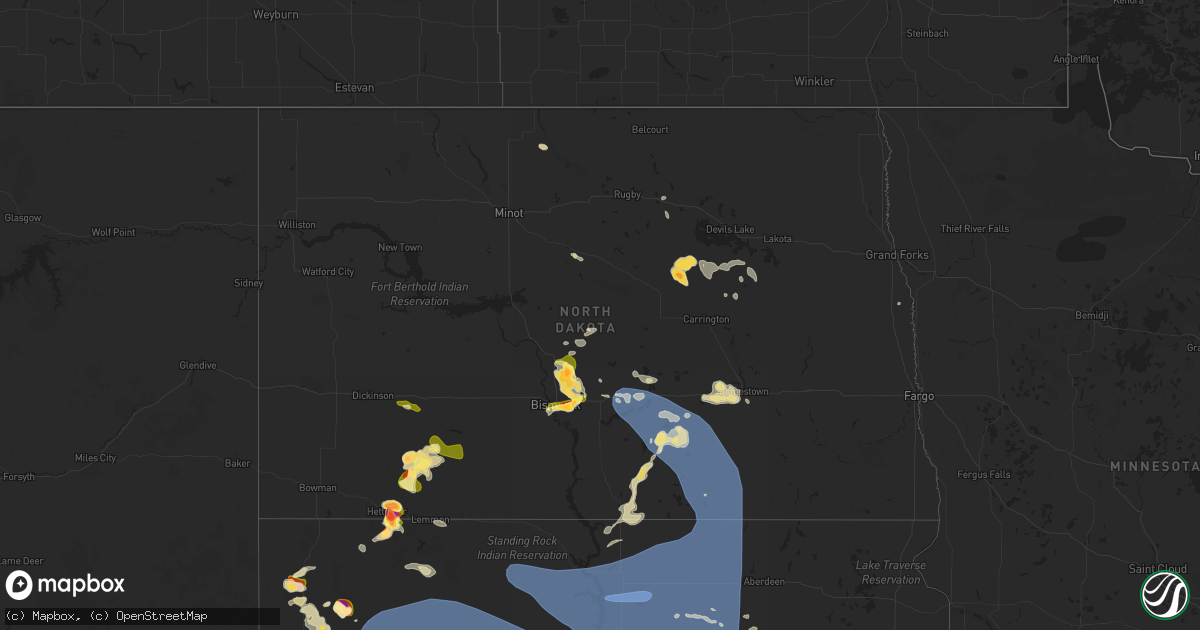
Hail Map in North Dakota on July 9, 2025
Get this storm
July 9 map
$229
one time, instant access
Download today. No call, no setup
Keep the $229
Bought the map and want the full workflow? Apply the entire $229 to a subscription within 7 days. None of it is wasted.
Every map, not just this one
This buys you this map. Subscription and you get every map we run, in the markets you choose from a few cities to whole states to nationwide. Plus real-time alerts the moment a storm fires.
Contact data
Name, contact info, occupancy, even credit band for addresses in the footprint. You go from where it hit to who to call.
Become the source they trust
Unlimited branding weather history reports on demand. You already have the documented answer ready for the property owner, and you are the one who showed up with it.
Property data and RoofTrace estimates
Pull up any address you have got, its value and the exact code rules for that jurisdiction, straight from One Click Code. Then RoofTrace estimates the squares, pitch, and roof value, priced the way you price.
Storm reports in North Dakota
North Dakota
| Date | Description |
|---|---|
| 07/09/20256:47 PM CDT | Social media report. Picture with measurement. |
| 07/09/20255:58 PM CDT | Broadcast media relayed report with picture. Time estimated based off radar. |
| 07/09/20255:05 PM CDT | Time estimated from radar. |
| 07/09/20254:30 PM CDT | Broadcast media relayed report with pictures. Time estimated by radar. |
| 07/09/20253:58 PM CDT | Pictures sent via social media. Dents also reported on cars. |
| 07/08/202510:08 PM CDT | Relayed through local broadcast media partner. Time estimated from radar. |
| 07/08/202510:05 PM CDT | Delayed report: relayed via social media time estimated via radar. |
| 07/08/20259:35 PM CDT | Time estimated from radar. |
| 07/08/20258:42 PM CDT | Updated ndawn observation. |
| 07/08/20258:37 PM CDT | Ndawn mesonet. |
| 07/08/20258:21 PM CDT | Delayed report from july 9th. |
| 07/08/20257:38 PM CDT | Time estimated from radar. |
| 07/08/20257:36 PM CDT | Social media report and photo of hail up to ping pong ball size. Started |
| 07/08/20257:36 PM CDT | Social media report and photo of hail up to ping pong ball size. Started at 719 pm with the largest stones at 736 pm. |
| 07/08/20257:30 PM CDT | Delayed report. |
| 07/08/20257:30 PM CDT | Social media report. Hail started at 7:10pm as pea size and eventually grew to golf ball size. Lasted 40 minutes. |
| 07/08/20257:25 PM CDT | Delayed report. Time estimated based off radar. |
| 07/08/20257:23 PM CDT | A local report indicates 1.25 inch wind near 3 NNW Bismarck |
| 07/08/20257:17 PM CDT | Relayed by nws employee. Lasted 10 minutes. |
All States Impacted by Hail Map on July 9, 2025
Cities Impacted by Hail Map on July 9, 2025
- Comanche, TX
- Newburg, ND
- Balfour, ND
- Saint Edward, NE
- Alapaha, GA
- Pullman, WV
- West Union, WV
- Berea, WV
- Auburn, WV
- New Milton, WV
- Harrisville, WV
- Pennsboro, WV
- Willacoochee, GA
- Ambrose, GA
- Whitesburg, KY
- Rochelle, GA
- Weston, WV
- Camden, WV
- Douglas, GA
- Hawkinsville, GA
- Pearson, GA
- Axson, GA
- Ermine, KY
- Nicholls, GA
- Abbeville, GA
- Roanoke, VA
- Pineview, GA
- Eastman, GA
- Troutville, VA
- Broxton, GA
- Gassaway, WV
- Cedarville, WV
- Exchange, WV
- Camilla, GA
- Cadwell, GA
- Waycross, GA
- Denton, GA
- Hazlehurst, GA
- Tarrytown, GA
- Cochran, GA
- Eagle Rock, VA
- Gable, SC
- Rhine, GA
- Ailey, GA
- Burnsville, WV
- Olanta, SC
- Milan, GA
- Flatwoods, WV
- Keysville, GA
- Waynesboro, GA
- Vidalia, GA
- Stapleton, GA
- Avera, GA
- Louisville, GA
- Eutawville, SC
- Napier, WV
- Walkersville, WV
- Heaters, WV
- Ireland, WV
- Alamo, GA
- McRae Helena, GA
- Jacksonville, GA
- Dorchester, SC
- Scranton, SC
- Collettsville, NC
- Lyons, GA
- Metter, GA
- Lumber City, GA
- Guyton, GA
- Rincon, GA
- Cross, SC
- Twin City, GA
- Mount Vernon, GA
- Uvalda, GA
- Glenwood, GA
- Holly Hill, SC
- Millen, GA
- Buffalo, SD
- Soperton, GA
- Garfield, GA
- Aiken, SC
- Lovingston, VA
- Denver City, TX
- Greenville, MI
- Sandy Level, VA
- Bowman, SC
- Reevesville, SC
- Saint George, SC
- Lehigh Acres, FL
- Branchville, SC
- Sardis, GA
- Windsor, SC
- Martinsville, VA
- Claxton, GA
- Fort Stewart, GA
- Rocky Ford, GA
- Sylvania, GA
- Ponce De Leon, FL
- Tampa, FL
- Belding, MI
- Rockford, MI
- Barnwell, SC
- Butler, GA
- Harbor Beach, MI
- Leesville, SC
- Okeechobee, FL
- Cape Coral, FL
- Arrington, VA
- Shipman, VA
- Schuyler, VA
- Wingina, VA
- Junction City, GA
- Pittsville, VA
- Vero Beach, FL
- Statesboro, GA
- Ruth, MI
- Wagener, SC
- Spencer, VA
- Corrigan, TX
- Moscow, TX
- Williston, SC
- Esmont, VA
- Ridgeway, VA
- Salley, SC
- Fairfax, SC
- Brunson, SC
- Prairie City, SD
- Springfield, SC
- Sanford, FL
- Lake Mary, FL
- Reva, SD
- Lodgepole, SD
- Penhook, VA
- Midville, GA
- Walnut Cove, NC
- Madison, NC
- Mayodan, NC
- Gretna, VA
- Chatham, VA
- Live Oak, FL
- Pelion, SC
- Batesburg, SC
- Lancaster, SC
- Heath Springs, SC
- Neeses, SC
- Pageland, SC
- Monroe, NC
- Winston Salem, NC
- Lemmon, SD
- Hettinger, ND
- Axton, VA
- Pine Hall, NC
- Walkertown, NC
- Mousie, KY
- Concord, VA
- North Fort Myers, FL
- Geneva, FL
- Marshville, NC
- Wingate, NC
- Clermont, FL
- Pine Ridge, SD
- Fairburn, SD
- Union Grove, NC
- Wayland, KY
- Raven, KY
- Red House, VA
- Mott, ND
- Allendale, SC
- Peachland, NC
- Polkton, NC
- Midland, VA
- Warrenton, VA
- Punta Gorda, FL
- Winter Garden, FL
- Kissimmee, FL
- Oviedo, FL
- Swansea, SC
- North, SC
- Blairs, VA
- Keeling, VA
- Vernon Hill, VA
- Orlando, FL
- Winnsboro, SC
- Great Falls, SC
- Remington, VA
- Bealeton, VA
- Bumpass, VA
- Spotsylvania, VA
- Mineral, VA
- Belews Creek, NC
- Newberry, SC
- Prosperity, SC
- Pomaria, SC
- Blair, SC
- Wounded Knee, SD
- Farmville, VA
- Keysville, VA
- Harmony, NC
- Catlett, VA
- Davenport, FL
- Stoneville, NC
- Java, VA
- South Boston, VA
- Appomattox, VA
- Brookneal, VA
- Stokesdale, NC
- Summerfield, NC
- Hampden Sydney, VA
- Nathalie, VA
- Conestoga, PA
- Millersville, PA
- Washington Boro, PA
- Eden, NC
- Bison, SD
- Meadow, SD
- Kernersville, NC
- Minden City, MI
- Albertville, AL
- Manderson, SD
- Porcupine, SD
- Bradley, SC
- Elkwood, VA
- Avon Park, FL
- Reidsville, NC
- Windermere, FL
- Meherrin, VA
- Green Bay, VA
- New London, NC
- Richfield, NC
- Crossville, AL
- Boaz, AL
- Cascade, VA
- Wrightsville, PA
- Oak Ridge, NC
- Denton, NC
- Wanblee, SD
- Allen, SD
- Kyle, SD
- Greensboro, NC
- Martin, SD
- Phenix, VA
- Charlotte Court House, VA
- Crewe, VA
- Polk City, FL
- Okatie, SC
- Bluffton, SC
- Arcadia, FL
- Felton, PA
- Lancaster, PA
- Rice, VA
- Wadesboro, NC
- Batesland, SD
- Mud Butte, SD
- Faith, SD
- Hampton, SC
- Varnville, SC
- Claremont, NC
- Rock Hill, SC
- High Point, NC
- Lexington, NC
- Catawba, NC
- Newton, NC
- Conover, NC
- Willow Street, PA
- Clifton, TX
- Asheboro, NC
- Sophia, NC
- Drakes Branch, VA
- Saxe, VA
- New Leipzig, ND
- Elon, NC
- Union Point, GA
- Randleman, NC
- Colfax, NC
- Burkeville, VA
- Thomasville, NC
- Red Lion, PA
- Browns Summit, NC
- Brogue, PA
- Stewartstown, PA
- Halifax, VA
- Long Valley, SD
- Norris, SD
- Burlington, NC
- Alto, TX
- Airville, PA
- Oxford, NC
- Nelson, VA
- Virgilina, VA
- Bullock, NC
- Tuthill, SD
- Dupree, SD
- Lantry, SD
- Eagle Butte, SD
- Newell, SD
- Stem, NC
- New Park, PA
- Liberty, NC
- Anniston, AL
- Gordon, NE
- Ona, FL
- McLaughlin, SD
- Timber Lake, SD
- Isabel, SD
- Belle Fourche, SD
- Mebane, NC
- Haw River, NC
- Julian, NC
- Climax, NC
- Whitsett, NC
- Chester, SC
- Maiden, NC
- Pequea, PA
- Rougemont, NC
- Trail City, SD
- Glencross, SD
- Whitehorse, SD
- Wakpala, SD
- Roundup, MT
- Graham, NC
- Lincolnton, NC
- Malone, TX
- Elgin, ND
- Glen Ullin, ND
- Bynum, TX
- Merriman, NE
- Wilton, ND
- Taylor, ND
- Gladstone, ND
- Richardton, ND
- Shelby, NC
- Lawndale, NC
- Strasburg, PA
- Baldwin, ND
- Regan, ND
- Clyde, OH
- Atlanta, GA
- Menoken, ND
- Sterling, ND
- Presho, SD
- Llano, TX
- Hague, VA
- Mcclusky, ND
- Mobridge, SD
- Selby, SD
- Glenham, SD
- Gettysburg, SD
- Akaska, SD
- Pierre, SD
- Agar, SD
- Onida, SD
- Hoven, SD
- Java, SD
- Bowdle, SD
- Eureka, SD
- Mound City, SD
- Bismarck, ND
- Hillsboro, TX
- Saint Francis, SD
- Kilgore, NE
- Crookston, NE
- Mission, SD
- Sparks, NE
- Springview, NE
- Valentine, NE
- Mullen, NE
- Thedford, NE
- Johnstown, NE
- Wood Lake, NE
- Seneca, NE
- Parmelee, SD
- Mandan, ND
- Okreek, SD
- Wood, SD
- White River, SD
- Winner, SD
- Witten, SD
- Rosebud, SD
- Vickery, OH
- Kennebec, SD
- Orange, VA
- Louisa, VA
- Elsmere, NE
- Ainsworth, NE
- Long Pine, NE
- Colbert, GA
- Crawford, GA
- Athens, GA
- North Port, FL
- Kershaw, SC
- Brandy Station, VA
- Harrold, SD
- Blunt, SD
- Fort Pierre, SD
- Lebanon, SD
- Holabird, SD
- Highmore, SD
- Lower Brule, SD
- Tolstoy, SD
- Hosmer, SD
- Ree Heights, SD
- Onaka, SD
- Orient, SD
- Roscoe, SD
- Stephan, SD
- Seneca, SD
- Fort Thompson, SD
- Miller, SD
- Faulkton, SD
- Saint Lawrence, SD
- Ipswich, SD
- Rockham, SD
- Cresbard, SD
- Tulare, SD
- Northville, SD
- Mansfield, SD
- Westport, SD
- Leola, SD
- Kulm, ND
- Fredonia, ND
- Forbes, ND
- Long Lake, SD
- Ellendale, ND
- Ashley, ND
- Edgeley, ND
- Frederick, SD
- Gackle, ND
- Lehr, ND
- Jud, ND
- Wishek, ND
- Streeter, ND
- Medina, ND
- Tappen, ND
- Napoleon, ND
- Dawson, ND
- Steele, ND
- Zeeland, ND
- Linton, ND
- Braddock, ND
- Kintyre, ND
- Driscoll, ND
- York, ND
- Burke, SD
- Wing, ND
- Herreid, SD
- Hague, ND
- Pollock, SD
- Robinson, ND
- Kinsale, VA
- Marco Island, FL
- Covington, GA
- Jacksonville, TX
- Leeds, ND
- Strasburg, ND
- Monroe, GA
- Sheyenne, ND
- Stapleton, NE
- Reliance, SD
- Henderson, NC
- Oxford, GA
- Harvey, ND
- Maddock, ND
- Lancaster, MN
- Oberon, ND
- Arnold, NE
- Watkinsville, GA
- Cleveland, ND
- Jamestown, ND
- Winterville, GA
- Callaway, NE
- Jefferson, TX
- Tolna, ND
- New Rockford, ND
- Goodland, FL
- Saint Michael, ND
- Warwick, ND
- Arnoldsville, GA
- Junction, TX
- Lynch, NE
- Ennis, TX
- Gann Valley, SD
- Kimball, SD
- Wessington, SD
- Wessington Springs, SD
- Alpena, SD
- Letcher, SD
- Plankinton, SD
- Woonsocket, SD
- Virgil, SD
- Wolsey, SD
- Fulton, SD
- Mitchell, SD
- Artesian, SD
- Carthage, SD
- Huron, SD
- De Smet, SD
- Hitchcock, SD
- Yale, SD
- Cavour, SD
- Fedora, SD
- Iroquois, SD
- Redfield, SD
- Page, NE
- Avon, SD
- Ewing, NE
- Orchard, NE
- Brady, NE
- Fort Myers, FL
- Blooming Grove, TX
- Verdigre, NE
- Oconto, NE
- Ringgold, VA
- Danville, VA
- Strandquist, MN
- Clearwater, NE
- Rice, TX
- Gothenburg, NE
- Barry, TX
- Creighton, NE
- Winnetoon, NE
- Petersburg, NE
- Elgin, NE
- Chambers, NE
- Italy, TX
- Center, NE
- Scotland, SD
- Delmont, SD
- Armour, SD
- Tripp, SD
- Parkston, SD
- Olivet, SD
- Cozad, NE
- Cathay, ND
- Yanceyville, NC
- Durham, NC
- Ashton, SD
- Midland, SD
- Tabor, SD
- Karlstad, MN
- Philip, SD
- Kadoka, SD
- Bloomfield, NE
- Wausa, NE
- Albion, NE
- Greenbush, MN
- Bartlett, NE
- Chapel Hill, NC
- Platte, SD
- Geddes, SD
- Harrison, SD
- Corsica, SD
- Wagner, SD
- Lake Andes, SD
- Dante, SD
- Tyndall, SD
- Kaylor, SD
- New Holland, SD
- Lesterville, SD
- Menno, SD
- Colome, SD
- Ideal, SD
- Canova, SD
- Alexandria, SD
- Howard, SD
- Spencer, SD
- Winfred, SD
- Oldham, SD
- Salem, SD
- Strathcona, MN
- Newfolden, MN
- Neligh, NE
- Fordyce, NE
- Hartington, NE
- Okaton, SD
- Battle Creek, NE
- Meadow Grove, NE
- Pierce, NE
- Belvidere, SD
- Scotia, NE
- Osmond, NE
- Mclean, NE
- Viking, MN
- Warren, MN
- Bishop, GA
- Ramona, SD
- Lake Preston, SD
- Madison, SD
- Union Center, SD
- Lexington, NE
- Murdo, SD
- Randolph, NE
- Wynot, NE
- Marion, SD
- Bridgewater, SD
- Belden, NE
- The Colony, TX
- Carrollton, TX
- Tilden, NE
- Montrose, SD
- Colton, SD
- Humboldt, SD
- Hartford, SD
- Canistota, SD
- Wentworth, SD
- Chester, SD
- Palmer, NE
- Wolbach, NE
- Humphrey, NE
- Winside, NE
- Draper, SD
- Vivian, SD
- Amherst, NE
- Laurel, NE
- Monroe, SD
- Milford, DE
- Carroll, NE
- Wayne, NE
- Platte Center, NE
- Monroe, NE
- Ravenna, NE
- Grand Island, NE
- Cairo, NE
- Wood River, NE
- Alda, NE
- Shelton, NE
- Pleasanton, NE
- Gibbon, NE
- Riverdale, NE
- Miller, NE
- Kearney, NE
- Thief River Falls, MN
- Fisher, MN
- East Grand Forks, MN
- Euclid, MN
- Creston, NE
- Parker, SD
- Stromsburg, NE
- Clarks, NE
- Grace City, ND
- Leigh, NE
- Columbus, NE
- Kenesaw, NE
- Polk, NE
- Wakefield, NE
- Minden, NE
- Juniata, NE
- Doniphan, NE
- Roseland, NE
- Hastings, NE
- Giltner, NE
- Trumbull, NE
- Henderson, NE
- Harvard, NE
- Aurora, NE
- Phillips, NE
- Hampton, NE
- Schuyler, NE
- Buxton, ND
- Marquette, NE
- Bradshaw, NE
- Hordville, NE
- Pender, NE
- Thurston, NE
- Elk Point, SD
- Westfield, IA
- Eatonton, GA
- Emerson, NE
- Shelby, NE
- Bellwood, NE
- Clarkson, NE
- Osceola, NE
- Andalusia, AL
- Sioux Falls, SD
- Winnebago, NE
- Homer, NE
- West Point, NE
- Marcus, IA
- Rising City, NE
- Rogers, NE
- Quimby, IA
- Cherokee, IA
- Cleghorn, IA
- Dakota City, NE
- Hubbard, NE
- Cushing, IA
- Holstein, IA
- Correctionville, IA
- Gresham, NE
- Dodge, NE
- Benedict, NE
- Larchwood, IA
- North Bend, NE
- Morse Bluff, NE
- Linwood, NE
- York, NE
- David City, NE
- Rosalie, NE
- Bancroft, NE
- Waco, NE
- Dell Rapids, SD
- Sutton, NE
- Inland, NE
- Glenvil, NE
- Ayr, NE
- Meriden, IA
- Magnolia, MN
- Saronville, NE
- Prague, NE
- Bruno, NE
- Brainard, NE
- Oakland, NE
- Scribner, NE
- Hooper, NE
- Macy, NE
- Walthill, NE
- Hills, MN
- Sloan, IA
- Washta, IA
- Utica, NE
- Neola, IA
- Persia, IA
- Malmo, NE
- Colon, NE
- McCool Junction, NE
- Adrian, MN
- Lismore, MN
- Onawa, IA
- Reading, MN
- Whiting, IA
- Uehling, NE
- Ute, IA
- Mapleton, IA
- Decatur, NE
- Bennington, NE
- Omaha, NE
- Battle Creek, IA
- Staplehurst, NE
- Luverne, MN
- Wahoo, NE
- Weston, NE
- Tekamah, NE
- Cedar Bluffs, NE
- Kenneth, MN
- Comstock, NE
- Elkhorn, NE
- Fairmont, NE
- Exeter, NE
- Shickley, NE
- Valparaiso, NE
- Gary, MN
- Ellsworth, MN
- Rock Rapids, IA
- Morris, MN
- Fertile, MN
- Ceresco, NE
- Geneva, NE
- Worthington, MN
- Ong, NE
- Edgar, NE
- Milford, NE
- Seward, NE
- Grafton, NE
- Ithaca, NE
- Hornick, IA
- Valley, NE
- Modale, IA
- Paullina, IA
- Sibley, IA
- Granville, IA
- Underwood, IA
- Sanborn, IA
- Charter Oak, IA
- Clare, IA
- Humboldt, IA
- Gretna, NE
- Friend, NE
- Milligan, NE
- Cylinder, IA
- Waterloo, NE
- Kennard, NE
- Missouri Valley, IA
- Bigelow, MN
- Davey, NE
- Raymond, NE
- Waverly, NE
- Ashton, IA
- Melvin, IA
- Carleton, NE
- Davenport, NE
- Windom, MN
- Glenwood, IA
- Bellevue, NE
- Council Bluffs, IA
- Lamberton, MN
- Wabasso, MN
- Springfield, NE
- Wilber, NE
- Western, NE
- Swanton, NE
- Hoffman, MN
- Heron Lake, MN
- Tobias, NE
- Greenwood, NE
- Ashland, NE
- Papillion, NE
- Minden, IA
- Boys Town, NE
- Ocheyedan, IA
- Harris, IA
- Alexandria, NE
- Bruning, NE
- Bassett, NE
- Hartley, IA
- Kensington, MN
- Kiron, IA
- Odebolt, IA
- Jansen, NE
- Plymouth, NE
- McClelland, IA
- Barrett, MN
- Hebron, NE
- Deshler, NE
- Arthur, IA
- Clatonia, NE
- Louisville, NE
- Plattsmouth, NE
- Silver City, IA
- Malvern, IA
- Milford, IA
- Treynor, IA
- Hallam, NE
- Schaller, IA
- Everly, IA
- Weeping Water, NE
- Cedar Creek, NE
- La Vista, NE
- Eagle Grove, IA
- Union, NE
- Spirit Lake, IA
- Denison, IA
- Vail, IA
- Taylor, NE
- De Witt, NE
- Spencer, IA
- Jackson, MN
- Lakefield, MN
- Hastings, IA
- Henderson, IA
- Dunbar, NE
- Murray, NE
- Alpha, MN
- Sleepy Eye, MN
- Oakland, IA
- Breda, IA
- Arcadia, IA
- Westside, IA
- Graettinger, IA
- Emmetsburg, IA
- Big Falls, MN
- Emerson, IA
- Pacific Junction, IA
- Beatrice, NE
- Dunnell, MN
- Menahga, MN
- Ayrshire, IA
- Curlew, IA
- Estherville, IA
- Nebraska City, NE
- Burwell, NE
- Malcolm, NE
- Lincoln, NE
- Pleasant Dale, NE
- Walton, NE
- Truman, MN
- Parkers Prairie, MN
- Welcome, MN
- Loman, MN
- New York Mills, MN
- Sebeka, MN
- Wadena, MN
- Bluffton, MN
- Ruthven, IA
- Rockwell City, IA
- Bennet, NE
- Offutt Afb, NE
- Mineola, IA
- Red Oak, IA
- Stanton, IA
- Johnson, NE
- Granada, MN
- Mallard, IA
- Saint James, MN
- Fairmont, MN
- Loup City, NE
- Woolstock, IA
- Henry, SD
- Watertown, SD
- Amelia, NE
- Litchfield, NE
- Winnebago, MN
- Clearfield, IA
- Verndale, MN
- Webster City, IA
- Essex, IA
- Algona, IA
- Park Rapids, MN
- Kelliher, MN
- Blackduck, MN
- Auburn, NE
- Hazard, NE
- Titonka, IA
- Lakota, IA
- Buffalo Center, IA
- Arcadia, NE
- Ord, NE
- Staples, MN
- Newport, NE
- Frost, MN
- Blue Earth, MN
- Garner, IA
- Kanawha, IA
- Goodell, IA
- Bricelyn, MN
- Thompson, IA
- Rake, IA
- Klemme, IA
- Mirando City, TX
- Bruni, TX
- Diagonal, IA
- Deer River, MN
- Hackensack, MN
- Backus, MN
- Blairsburg, IA
- Ackley, IA
- Longville, MN
- Rockville, NE
- Pine River, MN
- Wellsburg, IA
- Holstein, NE
- Hampton, IA
- Sheffield, IA
- Latimer, IA
- Dumont, IA
- Ashton, NE
- Boelus, NE
- Aplington, IA
- Aredale, IA
- Allison, IA
- Parkersburg, IA
- Geneva, IA
- Blue Hill, NE
- Waterloo, IA
- La Porte City, IA
- Guide Rock, NE
- Mankato, KS
- Burr Oak, KS
- Jesup, IA
- Gilbertville, IA
- Evansdale, IA
- Independence, IA
- Mount Auburn, IA
- Brandon, IA
- Hamill, SD


