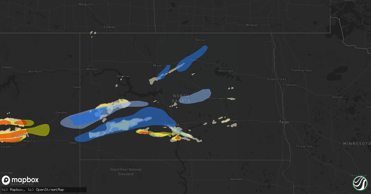
Hail Map in North Dakota on July 9, 2022
Get this storm
July 9 map
$229
one time, instant access
Download today. No call, no setup
Keep the $229
Bought the map and want the full workflow? Apply the entire $229 to a subscription within 7 days. None of it is wasted.
Every map, not just this one
This buys you this map. Subscription and you get every map we run, in the markets you choose from a few cities to whole states to nationwide. Plus real-time alerts the moment a storm fires.
Contact data
Name, contact info, occupancy, even credit band for addresses in the footprint. You go from where it hit to who to call.
Become the source they trust
Unlimited branding weather history reports on demand. You already have the documented answer ready for the property owner, and you are the one who showed up with it.
Property data and RoofTrace estimates
Pull up any address you have got, its value and the exact code rules for that jurisdiction, straight from One Click Code. Then RoofTrace estimates the squares, pitch, and roof value, priced the way you price.
Storm reports in North Dakota
North Dakota
| Date | Description |
|---|---|
| 07/09/202211:49 AM CDT | Relayed through social media. Report of dime to quarter size hail. |
| 07/09/202211:40 AM CDT | Estimated 60 mph winds with estimated penny size hail... Although spotter noted it was hard to tell hail size due to heavy rain. Reported crop damage as well. |
| 07/09/202210:55 AM CDT | Awos station ky19 mandan. |
| 07/09/20226:59 AM CDT | At 1158 PM MDT, a severe thunderstorm was located 18 miles south of Terry, moving east at 50 mph. HAZARD...70 mph wind gusts and half dollar size hail. SOURCE...Trained weather spotters. IMPACT...Hail damage to vehicles, considerable tree damage. Wind damage is also likely to mobile homes, roofs, and outbuildings. Locations impacted include... Baker, Plevna, Ismay, Ollie, Locate, Westmore and Knowlton. This replaces the warning previously in effect for this area. |
| 07/09/20226:54 AM CDT | Ndawn 10 meter wind gust of 58mph. |
| 07/09/20226:53 AM CDT | Asos station kjms jamestown nd airport asos |
| 07/09/20226:45 AM CDT | Ndawn station reported 63mph wind gust 8 miles north of mchenry. |
| 07/09/20226:45 AM CDT | Ndawn station reported |
| 07/09/20226:43 AM CDT | Ndawn station reported. |
| 07/09/20226:27 AM CDT | At 1126 PM MDT, severe thunderstorms were located along a line extending from 10 miles northwest of Circle to 15 miles north of Miles City, moving east at 60 mph. HAZARD...70 mph wind gusts and half dollar size hail. SOURCE...Radar indicated. IMPACT...Hail damage to vehicles is expected. Expect considerable tree damage. Wind damage is also likely to mobile homes, roofs, and outbuildings. Locations impacted include... Sidney, Glendive, Circle, Terry, Wibaux, Fallon, Fairview, Richey, Savage, West Glendive, Brockway, Intake, Bloomfield, Lambert, Vida, Nelson Creek Rec Area, Carlyle, Lindsay, Rock Creek Rec Area and Flowing Wells Rest Area. |
| 07/09/20226:23 AM CDT | At 1123 PM MDT, severe thunderstorms were located along a line extending from 6 miles north of Redstone to 8 miles south of Brockton, moving east at 85 mph. HAZARD...60 mph wind gusts and nickel size hail. SOURCE...Radar indicated. IMPACT...Expect damage to roofs, siding, and trees. Locations impacted include... Wolf Point, Plentywood, Scobey, Poplar, Culbertson, Brockton, Medicine Lake, Bainville, Froid, Westby, Flaxville, Archer, Port Of Raymond, Port Of Whitetail, Fort Union Trading Post, Madoc, Bredette, Port Of Scobey, Redstone and Whitetail. |
| 07/09/20226:14 AM CDT | At 1114 AM CDT, a severe thunderstorm was located 6 miles southeast of Lincoln, or 11 miles southeast of Bismarck, moving east at 30 mph. HAZARD...Ping pong ball size hail and 60 mph wind gusts. SOURCE...Radar indicated. IMPACT...People and animals outdoors will be injured. Expect hail damage to roofs, siding, windows, and vehicles. Expect wind damage to roofs, siding, and trees. Locations impacted include... Braddock. |
| 07/09/20225:52 AM CDT | Ndawn measured 60mph 10 meter wind gust. |
| 07/09/20225:50 AM CDT | A local report indicates 60 MPH wind near 1 W ROLETTE |
| 07/09/20225:46 AM CDT | Ndawn station wolford 4e. 10 meter measured wind gust. |
| 07/09/20225:38 AM CDT | At 1038 AM CDT, a severe thunderstorm was located 7 miles southwest of Mandan, moving east at 30 mph. HAZARD...60 mph wind gusts and quarter size hail. SOURCE...Radar indicated. IMPACT...Hail damage to vehicles is expected. Expect wind damage to roofs, siding, and trees. This severe thunderstorm will be near... Mandan around 1045 AM CDT. Bismarck around 1100 AM CDT. Lincoln around 1105 AM CDT. Mcdowell Dam Recreation Area around 1110 AM CDT.Other locations impacted by this severe thunderstorm includeUniversity Of Mary, Huff and Fort Abraham Lincoln State Park. |
| 07/09/20225:31 AM CDT | Measured wind gust from personal weather station. |
| 07/09/20225:30 AM CDT | At 1030 PM MDT, severe thunderstorms were located along a line extending from 11 miles southwest of Vida to 14 miles west of Terry, moving east at 60 mph. HAZARD...70 mph wind gusts and half dollar size hail. SOURCE...Radar indicated. IMPACT...Hail damage to vehicles is expected. Expect considerable tree damage. Wind damage is also likely to mobile homes, roofs, and outbuildings. Locations impacted include... Sidney, Glendive, Circle, Terry, Wibaux, Fallon, Fairview, Richey, Savage, West Glendive, Brockway, Hillside, Flowing Wells Rest Area, Intake, Bloomfield, Lambert, Vida, Cohagen, Nelson Creek Rec Area and Carlyle. |
| 07/09/20225:27 AM CDT | Large tree downed and crop damage. Report from social media. Time estimated from radar. |
| 07/09/20225:25 AM CDT | Measured wind gust from personal weather station. |
| 07/09/20225:20 AM CDT | Measured wind gust from personal weather station. |
| 07/09/20225:20 AM CDT | Nddot reporting site. |
| 07/09/20225:05 AM CDT | Nddot reporting site on the interstate 94 bridge. |
| 07/09/20225:02 AM CDT | Trees uprooted/down in perth. Relayed via social media. |
| 07/09/20224:45 AM CDT | Multiple large trees downed at cross ranch state park. Report from their facebook page with photos. |
| 07/09/20224:27 AM CDT | Measured wind gust from personal weather station. |
| 07/09/20224:25 AM CDT | Relayed through social media. Time estimated from radar. |
| 07/09/20224:14 AM CDT | Ndawn site. |
| 07/09/20224:14 AM CDT | Ndawn station sawyer 7s. Measured 10 meter wind gust. |
| 07/09/20223:55 AM CDT | Estimated 60 mph wind gusts were accompanied by one inch hail. The one inch hail lasted less than a minute. |
| 07/09/20223:50 AM CDT | Nddot site near golden valley. |
| 07/09/20223:30 AM CDT | Nddot site near gladstone. |
| 07/09/20223:12 AM CDT | Ndawn station fayette 3w. |
| 07/09/20223:12 AM CDT | Ndawn reporting site. |
| 07/09/20223:09 AM CDT | Measured wind gust from personal weather station. |
| 07/09/20223:05 AM CDT | Asos station kdik dickinson airport. |
| 07/09/20223:04 AM CDT | Measured wind gust from personal weather station. |
| 07/09/20223:01 AM CDT | Ndawn station dickinson 1nw. 10 meter measured wind gust. |
| 07/09/20222:49 AM CDT | Reported by the ndawn station. |
| 07/09/20222:36 AM CDT | Time estimated from radar. Report of a 150 foot tall tower that was downed by strong winds. There was also a 10 foot by 12 foot building with a lot of weight in it that |
| 07/09/20222:28 AM CDT | Social media report. |
| 07/09/20222:25 AM CDT | Ndawn station sentinel butte 10n. |
| 07/09/20222:19 AM CDT | Sustained wind was measured at 50 mph. Reported by the ndawn station. |
| 07/09/20222:17 AM CDT | 10 meter observation reported by the ndawn station. |
| 07/09/20222:17 AM CDT | Ndawn station beach 9s. Measured 10 meter wind gust. |
| 07/09/20222:15 AM CDT | Beach airport asos reported 79 mph gust. Emergency manager reported estimated 8 inch tree limbs down in beach. |
| 07/09/20222:00 AM CDT | Montana-dakota utilities reports entire town of beach is without power. Restoration time is unknown. |
| 07/09/20222:00 AM CDT | Very high winds 80-90 mph. Large trees uprooted... Power lines down all over town. Steets blocked with debris & down trees. Also had 1.30 inches of rain. Cocorahs obser |
| 07/09/20221:02 AM CDT | Raws site in northwest divide county. |
| 07/08/20229:44 PM CDT | At 243 AM CDT/143 AM MDT/, severe thunderstorms were located along a line extending from 6 miles east of Crosby to 7 miles north of Ray to near Arnegard, moving east at 55 mph. HAZARD...60 mph wind gusts. SOURCE...Radar indicated. At 220 AM CDT a 61 mph wind gust was reported at Charbonneau. IMPACT...Expect damage to roofs, siding, and trees. Severe thunderstorms will be near... Noonan around 250 AM CDT. Tioga around 255 AM CDT. Columbus around 300 AM CDT.Other locations in the path of these severe thunderstorms includeLignite, Portal, Ross, Stanley, Flaxton, Lostwood, Bowbells, Palermoand Blaisdell. |
All States Impacted by Hail Map on July 9, 2022
Cities Impacted by Hail Map on July 9, 2022
- Rugby, ND
- Brady, MT
- Dutton, MT
- Conrad, MT
- Valier, MT
- Ambrose, ND
- East Glacier Park, MT
- Underwood, ND
- Stanton, ND
- Polson, MT
- Bigfork, MT
- Monarch, MT
- Geyser, MT
- Raynesford, MT
- Neihart, MT
- Hazelton, ND
- Moffit, ND
- Bismarck, ND
- Menoken, ND
- Mandan, ND
- Belt, MT
- Holly Springs, MS
- Potts Camp, MS
- Stanford, MT
- Wilton, ND
- Clinton, MT
- Bonner, MT
- Deer Lodge, MT
- Chester, MT
- Shelby, MT
- Joplin, MT
- Galata, MT
- Rudyard, MT
- Inverness, MT
- Ledger, MT
- Lewisburg, TN
- Cornersville, TN
- Petersburg, TN
- Red Bay, AL
- Mchenry, ND
- New Rockford, ND
- Poyen, AR
- Malvern, AR
- Leola, AR
- Moscow, TN
- Arab, AL
- Rison, AR
- Douglas, ND
- Max, ND
- Sawyer, ND
- Minot, ND
- Ryder, ND
- Addison, AL
- Power, MT
- Fairfield, MT
- Winifred, MT
- Clancy, MT
- Helena, MT
- Double Springs, AL
- Oxford, MS
- Coffee Creek, MT
- Moundville, AL
- Philipsburg, MT
- Hingham, MT
- Box Elder, MT
- Gildford, MT
- Pope, MS
- Anaconda, MT
- Grenada, MS
- Holcomb, MS
- Tunica, MS
- Vaughn, MT
- Canton, MS
- Talladega, AL
- Pell City, AL
- Rayville, LA
- New Town, ND
- Slayton, MN
- Florence, AL
- Sheffield, AL
- Muscle Shoals, AL
- Lamar, MS
- Grand Marais, MN
- Cleveland, ND
- Mccall, ID
- Donnelly, ID
- Mesa, ID
- Council, ID
- Grants, NM
- Stevensville, MT
- Cherokee, AL
- Tuscumbia, AL
- Flora, MS
- Carbon Hill, AL
- Fulton, MS
- Boyle, MS
- Beach, ND
- Big Sandy, MT
- Selmer, TN
- Prescott, AR
- Blevins, AR
- Ashdown, AR
- Foreman, AR
- Judith Gap, MT
- Belfield, ND
- Mound Bayou, MS
- Shelby, MS
- Alligator, MS
- Duncan, MS
- Imnaha, OR
- Senatobia, MS
- Sarah, MS
- Madison, MS
- Brandon, MS
- Fulda, MN
- Avoca, MN
- Great Falls, MT
- Akron, AL
- Mount Pleasant, TX
- Regan, ND
- Velva, ND
- Wilsall, MT
- Ypsilanti, ND
- Jamestown, ND
- Hillsboro, AL
- Trinity, AL
- Baldwyn, MS
- Roundup, MT
- Blue Mountain, MS
- Logan, AL
- Cullman, AL
- Arley, AL
- Crane Hill, AL
- Vinemont, AL
- Butte, MT
- Mount Vernon, TX
- Jackson, MN
- Ashland, MS
- Lincoln, AL
- Riverside, AL
- Odenville, AL
- Ragland, AL
- Ashville, AL
- Shreveport, LA
- Mooringsport, LA
- Hackleburg, AL
- Yazoo City, MS
- Winona, MS
- Vaiden, MS
- Brewton, AL
- Delhi, LA
- Winnsboro, LA
- Baskin, LA
- Hico, TX
- West, MS
- Durant, MS
- Lexington, MS
- Cruger, MS
- Fort Shaw, MT
- Havre, MT
- Washburn, ND
- Medora, ND
- Medina, ND
- Heron Lake, MN
- Ramer, TN
- Guys, TN
- Michie, TN
- Alpine, AL
- West Point, MS
- Fort Benton, MT
- Grass Range, MT
- Cohagen, MT
- Denton, MT
- Fortuna, ND
- Hebron, ND
- South Heart, ND
- Gladstone, ND
- Lefor, ND
- New England, ND
- Dickinson, ND
- Richardton, ND
- New Salem, ND
- Amidon, ND
- Rhame, ND
- Taylor, ND
- Glen Ullin, ND
- Winston, MT
- East Helena, MT
- Condon, MT
- Granville, ND
- Voltaire, ND
- Karlsruhe, ND
- Towner, ND
- Winnett, MT
- Brusett, MT
- Mosby, MT
- Sand Springs, MT
- Courtland, MS
- Batesville, MS
- Almont, ND
- Carson, ND
- New Leipzig, ND
- Elgin, ND
- Buchanan, ND
- Floweree, MT
- Huntington, OR
- Cambridge, ID
- Midvale, ID
- Weiser, ID
- Hickory Flat, MS
- Kalispell, MT
- Mandaree, ND
- Rollins, MT
- Dayton, MT
- Lakeside, MT
- Somers, MT
- Choteau, MT
- Water Valley, MS
- Carthage, AR
- Grassy Butte, ND
- Killdeer, ND
- Fairfield, ND
- Manning, ND
- Dunn Center, ND
- Dodge, ND
- Halliday, ND
- Atlanta, TX
- Douglassville, TX
- Kilmichael, MS
- Collinston, LA
- Bastrop, LA
- Shawmut, MT
- Harlowton, MT
- Pine Bluff, AR
- Star City, AR
- Louisville, MS
- Calera, AL
- Tillar, AR
- Winchester, AR
- Pickens, AR
- Rolling Fork, MS
- Moulton, AL
- Childersburg, AL
- Jefferson, TX
- Leeds, AL
- Vandiver, AL
- Ferriday, LA
- Wagarville, AL
- Forsyth, MT
- Andalusia, AL
- Cropwell, AL
- Linden, TX
- Bivins, TX
- Franklin, AL
- Godley, TX
- Cleburne, TX
- Joshua, TX
- Range, AL
- Shelby, AL
- Columbiana, AL
- Jemison, AL
- Clanton, AL
- Sylacauga, AL
- Union Springs, AL
- Banks, AL
- San Angelo, TX
- Miles, TX
- Texarkana, TX
- Kinsey, MT
- Angela, MT
- Hamilton, AL
- Bear Creek, AL
- Florence, MS
- Graettinger, IA
- Milton, FL
- Millry, AL
- Harpersville, AL
- Ingomar, MT
- Pelahatchie, MS
- Morton, MS
- Vincent, AL
- Oakland, MS
- Jackson, MS
- Starkville, MS
- Macon, MS
- Tularosa, NM
- Jonesboro, TX
- Castleberry, AL
- Granbury, TX
- Chunchula, AL
- Citronelle, AL
- Maben, MS
- Mathiston, MS
- Wilsonville, AL
- Tupelo, MS
- Shannon, MS
- Pontotoc, MS
- Coila, MS
- Greenwood Springs, MS
- Smithville, MS
- Tremont, MS
- Bentonia, MS
- Cannon Ball, ND
- Linton, ND
- Solen, ND
- Nettleton, MS
- Clayton, AL
- Alabaster, AL
- Pelham, AL
- Dumas, AR
- Cedarbluff, MS
- Waskom, TX
- Greenwood, LA
- Marshall, TX
- Karnack, TX
- Dublin, TX
- Goldthwaite, TX
- Rowena, TX
- Drew, MS
- Repton, AL
- Lenox, AL
- Culleoka, TN
- Columbia, TN
- Jasper, AL
- Two Dot, MT
- Benton, MS
- Vaughan, MS
- Pickens, MS
- Pheba, MS
- Tolar, TX
- Midway, AL
- Leakey, TX
- Montevallo, AL
- Sterrett, AL
- Weogufka, AL
- Birmingham, AL
- Chelsea, AL
- Fosters, AL
- Braddock, ND
- Iuka, MS
- Counce, TN
- Corinth, MS
- Burnsville, MS
- Belcher, LA
- Greensboro, AL
- Ralph, AL
- Buhl, AL
- Gallant, AL
- Guntersville, AL
- Boaz, AL
- Holly Pond, AL
- Baileyton, AL
- Attalla, AL
- Blountsville, AL
- Steele, AL
- Oneonta, AL
- Joppa, AL
- Horton, AL
- Altoona, AL
- Delight, AR
- Ecru, MS
- Oak Ridge, LA
- Rising Star, TX
- Carbon, TX
- Tallulah, LA
- Evergreen, AL
- Lavina, MT
- Hodges, AL
- Musselshell, MT
- Socorro, NM
- Conner, MT
- Darby, MT
- Downsville, LA
- Berry, AL
- Aberdeen, MS
- Glenfield, ND
- Saltillo, MS
- Mooreville, MS
- Saint Anthony, ND
- Vicksburg, MS
- Newellton, LA
- Okolona, MS
- Sardis, MS
- Taylor, MS
- Tuscaloosa, AL
- Prairie, MS
- Sunflower, MS
- Indianola, MS
- Hayneville, AL
- Mer Rouge, LA
- Byram, MS
- McIntosh, AL
- Lena, MS
- McCarley, MS
- Guntown, MS
- Troy, AL
- Arkadelphia, AR
- Houston, AL
- Plantersville, MS
- Verona, MS
- Gilbert, LA
- Forest Grove, MT
- Rosebud, MT
- Ryegate, MT
- Custer, MT
- Melstone, MT
- Hysham, MT
- Clarksdale, MS
- Oil City, LA
- Vivian, LA
- Baker, FL
- Estherville, IA
- Wallingford, IA
- Flasher, ND
- Haleyville, AL
- Moody, AL
- Kintyre, ND
- Napoleon, ND
- Belden, MS
- Como, MS
- Vina, AL
- Springville, AL
- Shaw, MS
- Texarkana, AR
- Greenville, MS
- Maud, TX
- Ruthven, IA
- Little River, AL
- Coffeeville, MS
- Dexter, NM
- Roswell, NM
- Iredell, TX
- Meridian, TX
- Greenwood, MS
- Nashville, AR
- Eldridge, AL
- Wing, AL
- Jay, FL
- Natchez, MS
- Tappen, ND
- Lynn, AL
- Nauvoo, AL
- Livingston, AL
- Garrison, MT
- Big Sandy, TX
- Eva, AL
- Townley, AL
- Lometa, TX
- Evant, TX
- Jackson, AL
- Stockton, AL
- Clifton, TX
- Terry, MT
- Fallon, MT
- Ismay, MT
- Amory, MS
- Leland, MS
- Inverness, MS
- Itta Bena, MS
- Tchula, MS
- Belzoni, MS
- Moorhead, MS
- Hazen, ND
- Glendive, MT
- Golden Valley, ND
- Wibaux, MT
- Golva, ND
- Zap, ND
- Sentinel Butte, ND
- Beulah, ND
- Marmarth, ND
- Baker, MT
- Center, ND
- Baldwin, ND
- Denhoff, ND
- Goodrich, ND
- Wing, ND
- Hurdsfield, ND
- Bowdon, ND
- Mcclusky, ND
- Harvey, ND
- Fessenden, ND
- Cathay, ND
- Chaseley, ND
- Sykeston, ND
- Norwich, ND
- Willow City, ND
- Agate, ND
- Rolette, ND
- Drake, ND
- Balfour, ND
- Wolford, ND
- Mylo, ND


