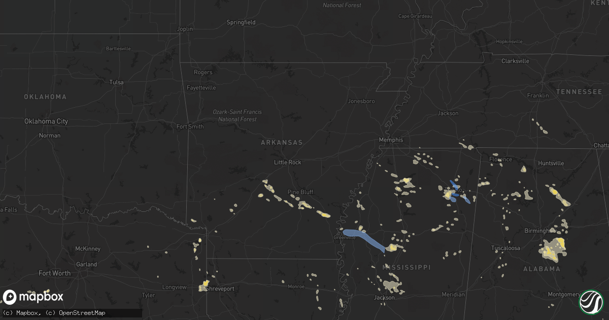
Hail Map in Arkansas on July 9, 2022
Get this storm
July 9 map
$229
one time, instant access
Download today. No call, no setup
Keep the $229
Bought the map and want the full workflow? Apply the entire $229 to a subscription within 7 days. None of it is wasted.
Every map, not just this one
This buys you this map. Subscription and you get every map we run, in the markets you choose from a few cities to whole states to nationwide. Plus real-time alerts the moment a storm fires.
Contact data
Name, contact info, occupancy, even credit band for addresses in the footprint. You go from where it hit to who to call.
Become the source they trust
Unlimited branding weather history reports on demand. You already have the documented answer ready for the property owner, and you are the one who showed up with it.
Property data and RoofTrace estimates
Pull up any address you have got, its value and the exact code rules for that jurisdiction, straight from One Click Code. Then RoofTrace estimates the squares, pitch, and roof value, priced the way you price.
Storm reports in Arkansas
Arkansas
| Date | Description |
|---|---|
| 07/09/20225:05 PM CDT | Trees were blown down on belmont street near the community center. |
| 07/09/20224:43 PM CDT | A power line was blown down onto highway 54 near holly springs. |
| 07/09/20224:29 PM CDT | Trees were blown down on avalon road just north of star city. |
| 07/09/20224:26 PM CDT | Trees were blown down on alco road west of star city. Report relayed by south arkansas weather social media account. |
| 07/09/20224:26 PM CDT | Trees were blown down on amherst road north of star city. Report relayed by south arkansas weather social media account. |
| 07/08/202211:41 PM CDT | At 440 PM CDT, a severe thunderstorm was located near Cane Creek State Park, or 7 miles southeast of Star City, moving southeast at 40 mph. HAZARD...60 mph wind gusts and penny size hail. SOURCE...Radar indicated. IMPACT...Expect damage to roofs, siding, and trees. Locations impacted include... Dumas... Star City... Gould... Mitchellville... Winchester... Omega... Cane Creek State Park... Mills... Garrett Bridge... Gourd... Florence... Enon... Tyro... Rose Hill... Reedville... Crigler... Selma... Yukon... Montongo... Relfs Bluff... |
| 07/08/202211:24 PM CDT | At 423 PM CDT, a severe thunderstorm was located over Feenyville, or near Star City, moving southeast at 35 mph. HAZARD...60 mph wind gusts and penny size hail. SOURCE...Radar indicated. IMPACT...Expect damage to roofs, siding, and trees. Locations impacted include... Star City... Gould... Nebo... Feenyville... Plantersville... Cane Creek State Park... Glendale in Lincoln County... Calhoun... Cornerville... Rowell... Palmyra... Rose Hill... Crigler... Fresno... Calmer... Garnett... Avery... Yorktown... Relfs Bluff... |
| 07/08/20229:33 PM CDT | At 233 PM CDT, a severe thunderstorm was located over Thiel, or 11 miles southeast of Malvern, moving southeast at 15 mph. HAZARD...60 mph wind gusts and penny size hail. SOURCE...Radar indicated. IMPACT...Expect damage to roofs, siding, and trees. Locations impacted include... Leola... Prattsville... Poyen... Jenkins Ferry State Park... Thiel... Dogwood... Lono... Cross Roads in Grant County... Brush Creek... |
| 07/08/20229:02 PM CDT | At 201 PM CDT, a severe thunderstorm was located near Perla, or near Malvern, moving east at 15 mph. HAZARD...60 mph wind gusts and penny size hail. SOURCE...Radar indicated. IMPACT...Expect damage to roofs, siding, and trees. Locations impacted include... Malvern... Haskell... Rockport... Traskwood... Tull... Prattsville... Poyen... Perla... Thiel... Jenkins Ferry State Park... Magnet Cove... Fenter... Gifford... Shaw... Glen Rose... Buie...This includes Interstate 30 between mile markers 93 and 109. |
All States Impacted by Hail Map on July 9, 2022
Cities Impacted by Hail Map on July 9, 2022
- Rugby, ND
- Brady, MT
- Dutton, MT
- Conrad, MT
- Valier, MT
- Ambrose, ND
- East Glacier Park, MT
- Underwood, ND
- Stanton, ND
- Polson, MT
- Bigfork, MT
- Monarch, MT
- Geyser, MT
- Raynesford, MT
- Neihart, MT
- Hazelton, ND
- Moffit, ND
- Bismarck, ND
- Menoken, ND
- Mandan, ND
- Belt, MT
- Holly Springs, MS
- Potts Camp, MS
- Stanford, MT
- Wilton, ND
- Clinton, MT
- Bonner, MT
- Deer Lodge, MT
- Chester, MT
- Shelby, MT
- Joplin, MT
- Galata, MT
- Rudyard, MT
- Inverness, MT
- Ledger, MT
- Lewisburg, TN
- Cornersville, TN
- Petersburg, TN
- Red Bay, AL
- Mchenry, ND
- New Rockford, ND
- Poyen, AR
- Malvern, AR
- Leola, AR
- Moscow, TN
- Arab, AL
- Rison, AR
- Douglas, ND
- Max, ND
- Sawyer, ND
- Minot, ND
- Ryder, ND
- Addison, AL
- Power, MT
- Fairfield, MT
- Winifred, MT
- Clancy, MT
- Helena, MT
- Double Springs, AL
- Oxford, MS
- Coffee Creek, MT
- Moundville, AL
- Philipsburg, MT
- Hingham, MT
- Box Elder, MT
- Gildford, MT
- Pope, MS
- Anaconda, MT
- Grenada, MS
- Holcomb, MS
- Tunica, MS
- Vaughn, MT
- Canton, MS
- Talladega, AL
- Pell City, AL
- Rayville, LA
- New Town, ND
- Slayton, MN
- Florence, AL
- Sheffield, AL
- Muscle Shoals, AL
- Lamar, MS
- Grand Marais, MN
- Cleveland, ND
- Mccall, ID
- Donnelly, ID
- Mesa, ID
- Council, ID
- Grants, NM
- Stevensville, MT
- Cherokee, AL
- Tuscumbia, AL
- Flora, MS
- Carbon Hill, AL
- Fulton, MS
- Boyle, MS
- Beach, ND
- Big Sandy, MT
- Selmer, TN
- Prescott, AR
- Blevins, AR
- Ashdown, AR
- Foreman, AR
- Judith Gap, MT
- Belfield, ND
- Mound Bayou, MS
- Shelby, MS
- Alligator, MS
- Duncan, MS
- Imnaha, OR
- Senatobia, MS
- Sarah, MS
- Madison, MS
- Brandon, MS
- Fulda, MN
- Avoca, MN
- Great Falls, MT
- Akron, AL
- Mount Pleasant, TX
- Regan, ND
- Velva, ND
- Wilsall, MT
- Ypsilanti, ND
- Jamestown, ND
- Hillsboro, AL
- Trinity, AL
- Baldwyn, MS
- Roundup, MT
- Blue Mountain, MS
- Logan, AL
- Cullman, AL
- Arley, AL
- Crane Hill, AL
- Vinemont, AL
- Butte, MT
- Mount Vernon, TX
- Jackson, MN
- Ashland, MS
- Lincoln, AL
- Riverside, AL
- Odenville, AL
- Ragland, AL
- Ashville, AL
- Shreveport, LA
- Mooringsport, LA
- Hackleburg, AL
- Yazoo City, MS
- Winona, MS
- Vaiden, MS
- Brewton, AL
- Delhi, LA
- Winnsboro, LA
- Baskin, LA
- Hico, TX
- West, MS
- Durant, MS
- Lexington, MS
- Cruger, MS
- Fort Shaw, MT
- Havre, MT
- Washburn, ND
- Medora, ND
- Medina, ND
- Heron Lake, MN
- Ramer, TN
- Guys, TN
- Michie, TN
- Alpine, AL
- West Point, MS
- Fort Benton, MT
- Grass Range, MT
- Cohagen, MT
- Denton, MT
- Fortuna, ND
- Hebron, ND
- South Heart, ND
- Gladstone, ND
- Lefor, ND
- New England, ND
- Dickinson, ND
- Richardton, ND
- New Salem, ND
- Amidon, ND
- Rhame, ND
- Taylor, ND
- Glen Ullin, ND
- Winston, MT
- East Helena, MT
- Condon, MT
- Granville, ND
- Voltaire, ND
- Karlsruhe, ND
- Towner, ND
- Winnett, MT
- Brusett, MT
- Mosby, MT
- Sand Springs, MT
- Courtland, MS
- Batesville, MS
- Almont, ND
- Carson, ND
- New Leipzig, ND
- Elgin, ND
- Buchanan, ND
- Floweree, MT
- Huntington, OR
- Cambridge, ID
- Midvale, ID
- Weiser, ID
- Hickory Flat, MS
- Kalispell, MT
- Mandaree, ND
- Rollins, MT
- Dayton, MT
- Lakeside, MT
- Somers, MT
- Choteau, MT
- Water Valley, MS
- Carthage, AR
- Grassy Butte, ND
- Killdeer, ND
- Fairfield, ND
- Manning, ND
- Dunn Center, ND
- Dodge, ND
- Halliday, ND
- Atlanta, TX
- Douglassville, TX
- Kilmichael, MS
- Collinston, LA
- Bastrop, LA
- Shawmut, MT
- Harlowton, MT
- Pine Bluff, AR
- Star City, AR
- Louisville, MS
- Calera, AL
- Tillar, AR
- Winchester, AR
- Pickens, AR
- Rolling Fork, MS
- Moulton, AL
- Childersburg, AL
- Jefferson, TX
- Leeds, AL
- Vandiver, AL
- Ferriday, LA
- Wagarville, AL
- Forsyth, MT
- Andalusia, AL
- Cropwell, AL
- Linden, TX
- Bivins, TX
- Franklin, AL
- Godley, TX
- Cleburne, TX
- Joshua, TX
- Range, AL
- Shelby, AL
- Columbiana, AL
- Jemison, AL
- Clanton, AL
- Sylacauga, AL
- Union Springs, AL
- Banks, AL
- San Angelo, TX
- Miles, TX
- Texarkana, TX
- Kinsey, MT
- Angela, MT
- Hamilton, AL
- Bear Creek, AL
- Florence, MS
- Graettinger, IA
- Milton, FL
- Millry, AL
- Harpersville, AL
- Ingomar, MT
- Pelahatchie, MS
- Morton, MS
- Vincent, AL
- Oakland, MS
- Jackson, MS
- Starkville, MS
- Macon, MS
- Tularosa, NM
- Jonesboro, TX
- Castleberry, AL
- Granbury, TX
- Chunchula, AL
- Citronelle, AL
- Maben, MS
- Mathiston, MS
- Wilsonville, AL
- Tupelo, MS
- Shannon, MS
- Pontotoc, MS
- Coila, MS
- Greenwood Springs, MS
- Smithville, MS
- Tremont, MS
- Bentonia, MS
- Cannon Ball, ND
- Linton, ND
- Solen, ND
- Nettleton, MS
- Clayton, AL
- Alabaster, AL
- Pelham, AL
- Dumas, AR
- Cedarbluff, MS
- Waskom, TX
- Greenwood, LA
- Marshall, TX
- Karnack, TX
- Dublin, TX
- Goldthwaite, TX
- Rowena, TX
- Drew, MS
- Repton, AL
- Lenox, AL
- Culleoka, TN
- Columbia, TN
- Jasper, AL
- Two Dot, MT
- Benton, MS
- Vaughan, MS
- Pickens, MS
- Pheba, MS
- Tolar, TX
- Midway, AL
- Leakey, TX
- Montevallo, AL
- Sterrett, AL
- Weogufka, AL
- Birmingham, AL
- Chelsea, AL
- Fosters, AL
- Braddock, ND
- Iuka, MS
- Counce, TN
- Corinth, MS
- Burnsville, MS
- Belcher, LA
- Greensboro, AL
- Ralph, AL
- Buhl, AL
- Gallant, AL
- Guntersville, AL
- Boaz, AL
- Holly Pond, AL
- Baileyton, AL
- Attalla, AL
- Blountsville, AL
- Steele, AL
- Oneonta, AL
- Joppa, AL
- Horton, AL
- Altoona, AL
- Delight, AR
- Ecru, MS
- Oak Ridge, LA
- Rising Star, TX
- Carbon, TX
- Tallulah, LA
- Evergreen, AL
- Lavina, MT
- Hodges, AL
- Musselshell, MT
- Socorro, NM
- Conner, MT
- Darby, MT
- Downsville, LA
- Berry, AL
- Aberdeen, MS
- Glenfield, ND
- Saltillo, MS
- Mooreville, MS
- Saint Anthony, ND
- Vicksburg, MS
- Newellton, LA
- Okolona, MS
- Sardis, MS
- Taylor, MS
- Tuscaloosa, AL
- Prairie, MS
- Sunflower, MS
- Indianola, MS
- Hayneville, AL
- Mer Rouge, LA
- Byram, MS
- McIntosh, AL
- Lena, MS
- McCarley, MS
- Guntown, MS
- Troy, AL
- Arkadelphia, AR
- Houston, AL
- Plantersville, MS
- Verona, MS
- Gilbert, LA
- Forest Grove, MT
- Rosebud, MT
- Ryegate, MT
- Custer, MT
- Melstone, MT
- Hysham, MT
- Clarksdale, MS
- Oil City, LA
- Vivian, LA
- Baker, FL
- Estherville, IA
- Wallingford, IA
- Flasher, ND
- Haleyville, AL
- Moody, AL
- Kintyre, ND
- Napoleon, ND
- Belden, MS
- Como, MS
- Vina, AL
- Springville, AL
- Shaw, MS
- Texarkana, AR
- Greenville, MS
- Maud, TX
- Ruthven, IA
- Little River, AL
- Coffeeville, MS
- Dexter, NM
- Roswell, NM
- Iredell, TX
- Meridian, TX
- Greenwood, MS
- Nashville, AR
- Eldridge, AL
- Wing, AL
- Jay, FL
- Natchez, MS
- Tappen, ND
- Lynn, AL
- Nauvoo, AL
- Livingston, AL
- Garrison, MT
- Big Sandy, TX
- Eva, AL
- Townley, AL
- Lometa, TX
- Evant, TX
- Jackson, AL
- Stockton, AL
- Clifton, TX
- Terry, MT
- Fallon, MT
- Ismay, MT
- Amory, MS
- Leland, MS
- Inverness, MS
- Itta Bena, MS
- Tchula, MS
- Belzoni, MS
- Moorhead, MS
- Hazen, ND
- Glendive, MT
- Golden Valley, ND
- Wibaux, MT
- Golva, ND
- Zap, ND
- Sentinel Butte, ND
- Beulah, ND
- Marmarth, ND
- Baker, MT
- Center, ND
- Baldwin, ND
- Denhoff, ND
- Goodrich, ND
- Wing, ND
- Hurdsfield, ND
- Bowdon, ND
- Mcclusky, ND
- Harvey, ND
- Fessenden, ND
- Cathay, ND
- Chaseley, ND
- Sykeston, ND
- Norwich, ND
- Willow City, ND
- Agate, ND
- Rolette, ND
- Drake, ND
- Balfour, ND
- Wolford, ND
- Mylo, ND


