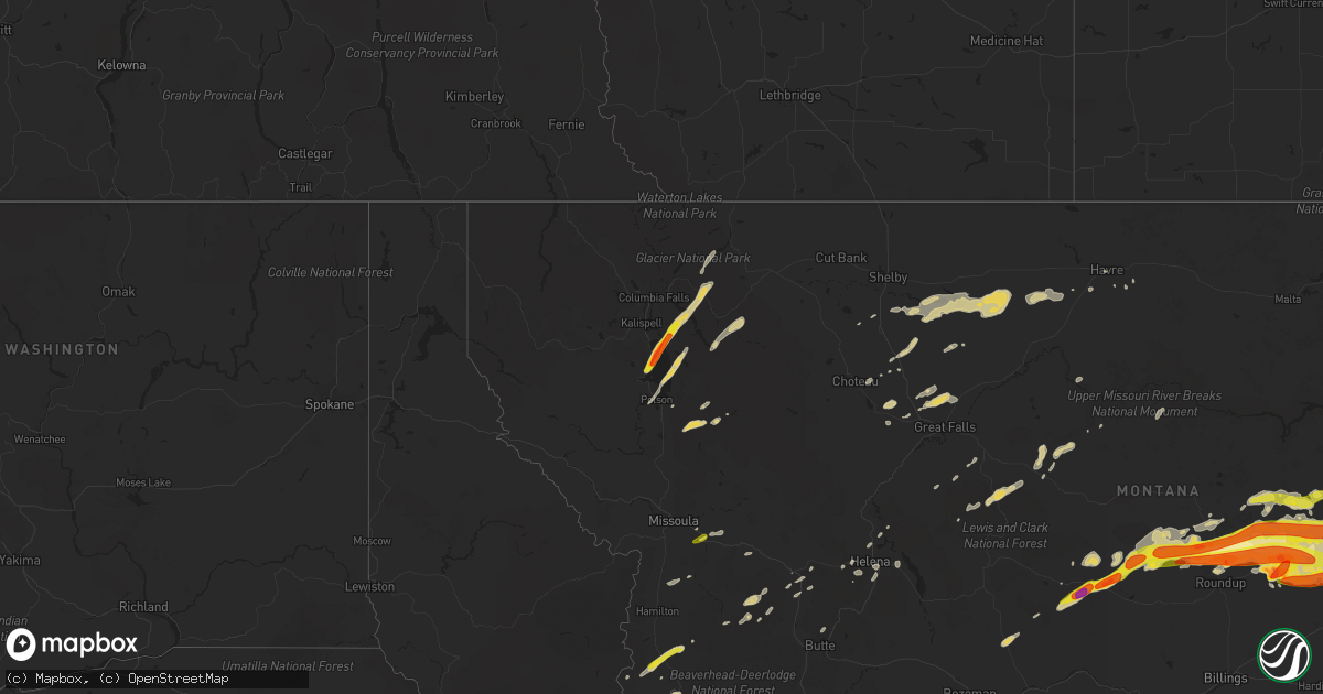
Hail Map on July 9, 2022
Get this storm
July 9 map
$229
one time, instant access
Download today. No call, no setup
Keep the $229
Bought the map and want the full workflow? Apply the entire $229 to a subscription within 7 days. None of it is wasted.
Every map, not just this one
This buys you this map. Subscription and you get every map we run, in the markets you choose from a few cities to whole states to nationwide. Plus real-time alerts the moment a storm fires.
Contact data
Name, contact info, occupancy, even credit band for addresses in the footprint. You go from where it hit to who to call.
Become the source they trust
Unlimited branding weather history reports on demand. You already have the documented answer ready for the property owner, and you are the one who showed up with it.
Property data and RoofTrace estimates
Pull up any address you have got, its value and the exact code rules for that jurisdiction, straight from One Click Code. Then RoofTrace estimates the squares, pitch, and roof value, priced the way you price.
States Impacted by Hail Map on July 9, 2022
Storm reports
Arizona
| Date | Description |
|---|---|
| 07/08/202210:49 PM CDT | At 346 PM MST, a severe thunderstorm was located 3 miles south of San Simon, or 13 miles north of Chiricahua National Monument, moving west at 15 mph. HAZARD...60 mph wind gusts and quarter size hail. SOURCE...Radar indicated. IMPACT...Hail damage to vehicles is expected. Expect wind damage to roofs, siding, and trees. Locations impacted include... Bowie and San Simon. |
Alabama
| Date | Description |
|---|---|
| 07/09/20226:48 PM CDT | A few trees were blown down in and around chelsea. |
| 07/09/20226:36 PM CDT | A few trees were blown down from woodstock to near west blocton. |
| 07/09/20226:23 PM CDT | Sporadic tree down reports including vestavia hills... Hoover... Mountain brook. |
| 07/09/20225:52 PM CDT | Report of 4 inch tree limbs down in yard... Carport across the street flipped... A large tree uprooted down the street... And large limbs down on neighbors house. Time |
| 07/09/20225:42 PM CDT | A few trees were blown down around pell city. |
| 07/09/20225:14 PM CDT | A few trees were blown down in and around guin. |
| 07/09/20225:07 PM CDT | A few trees were blown down in and around winfield. |
| 07/09/20225:00 PM CDT | A local report indicates 64 MPH wind near 1 N SOUTHSIDE |
| 07/09/20224:59 PM CDT | Corrects previous tstm wnd dmg report from 1 nnw guin. A few trees were blown down in and around guin. |
| 07/09/20224:46 PM CDT | Corrects previous tstm wnd dmg report from 7 s town creek. Report of 4 inch tree limbs down in yard... Carport across the street flipped... A large tree uprooted down t |
| 07/09/20224:38 PM CDT | Several trees were blown down in and around hamilton. |
| 07/09/20224:32 PM CDT | Several trees and power lines were blown down mainly just east of vincent to harpersville. A few roadways were blocked. |
| 07/09/20224:30 PM CDT | Damage to shed like structures... As well as tractor trailor rigs blown over |
| 07/09/20224:30 PM CDT | Tree downed at ricks ln and fuller store rd. |
| 07/09/20224:24 PM CDT | A local report indicates 68 MPH wind near 2 WNW GALLANT |
| 07/09/20224:22 PM CDT | Corrects previous tstm wnd dmg report from 5 sw leighton. Tree downed at ricks ln and fuller store rd. |
| 07/09/20224:21 PM CDT | A tree was reported down at 3171 ricks lane. Time was estimated from radar. |
| 07/09/20224:20 PM CDT | Tree downed at spring valley rd and three mile ln. |
| 07/09/20224:20 PM CDT | A tree was reported down at 848 golf drive near the intersection of gargis lane and bracken drive. Time was estimated from radar. |
| 07/09/20224:19 PM CDT | Corrects previous tstm wnd dmg report from 5 nne littleville. Tree downed at spring valley rd and three mile ln. |
| 07/09/20224:16 PM CDT | A storage shed was blown across a roadway and destroyed near hopewell road. |
| 07/09/20224:14 PM CDT | A tree was reported down at the intersection of pepi drive and 2nd street. |
| 07/09/20224:12 PM CDT | A tree was reported down at the intersection of reservation road and ccc camp road. |
| 07/09/20224:12 PM CDT | Report from mping: 3-inch tree limbs broken; power poles broken. |
| 07/09/20224:11 PM CDT | Corrects previous tstm wnd dmg report from 2 nnw muscle shoals. A tree was reported down at the intersection of reservation road and ccc camp road. |
| 07/09/20223:49 PM CDT | Multiple trees and power lines were blown down. A few manufactured homes were damaged. A storage shed was blown across a roadway and destroyed. |
| 07/09/20223:49 PM CDT | Corrects previous tstm wnd dmg report from 2 se strawberry. A storage shed was blown across a roadway and destroyed near hopewell road. |
| 07/09/20221:36 AM CDT | At 636 AM CDT, a severe thunderstorm was located near Glen, or 10 miles south of Corinth, moving southeast at 25 mph. HAZARD...60 mph wind gusts. SOURCE...Radar indicated. IMPACT...Expect damage to roofs, siding, and trees. Locations impacted include... Corinth, Booneville, Iuka, Tishomingo State Park, Burnsville, Glen, Tishomingo, Thrashers, Hinkle, Burton, Midway, Leedy, Farmington, Rienzi, Paden, Oldham, Thrasher, Dennis, Strickland and Blythe Crossing. |
| 07/09/20221:21 AM CDT | At 621 PM CDT, severe thunderstorms were located along a line extending from Birmingham to near Lake View, moving southeast at 35 mph. HAZARD...60 mph wind gusts. SOURCE...Radar indicated. IMPACT...Expect damage to roofs, siding, and trees. Locations impacted include... Birmingham, Hoover, Vestavia Hills, Alabaster, Bessemer, Homewood, Pelham, Mountain Brook, Trussville, Helena, Hueytown, Irondale, Leeds, Moody, Calera, Fairfield, Chelsea, Montevallo, Columbiana and Wilsonville. |
| 07/09/202212:06 AM CDT | At 505 PM CDT, a severe thunderstorm was located over Bon Air, or over Childersburg, moving southeast at 10 mph. HAZARD...60 mph wind gusts. SOURCE...Radar indicated. IMPACT...Expect damage to roofs, siding, and trees. Locations impacted include... Sylacauga, Childersburg, Oak Grove, Bon Air, Sycamore, Winterboro and Mignon. |
| 07/09/202212:00 AM CDT | At 500 PM CDT, a severe thunderstorm was located over Trinity, or 8 miles west of Decatur, moving southeast at 30 mph. HAZARD...60 mph wind gusts. SOURCE...Radar indicated. IMPACT...Expect damage to roofs, siding, and trees. Locations impacted include... Decatur, Hartselle, Priceville, Trinity, Hillsboro, Chalybeate Springs, Speake, Neel, Caddo and Basham. |
| 07/08/202211:41 PM CDT | At 441 PM CDT, severe thunderstorms were located along a line extending from near Helicon to near Lake Buttahatchee, moving southeast at 15 mph. HAZARD...60 mph wind gusts. SOURCE...Radar indicated. IMPACT...Expect damage to roofs, siding, and trees. Locations impacted include... Lynn, Arley, Double Springs, Addison, Nauvoo, Houston Recreational Area, Camp McDowell, Nesmith, Ashbank, Poplar Springs, Falls City, Moreland, Smith Lake, Helicon, Inmanfield, Sardis, Corinth Rec Area, Winston Free State Barn, Houston and Natural Bridge. |
| 07/08/202211:31 PM CDT | At 431 PM CDT, a severe thunderstorm was located near Altoona, or 10 miles west of Attalla, moving southeast at 20 mph. HAZARD...60 mph wind gusts. SOURCE...Radar indicated. IMPACT...Expect damage to roofs, siding, and trees. Locations impacted include... Gadsden, Rainbow City, Attalla, Hokes Bluff, Glencoe, Ashville, Ragland, Steele, Altoona, Walnut Grove, Reece City, Gadsden Mall, Neely Henry Lake, Southside, Whitney Junction, Alabama International Dragway, Gadsden Steam Plant, I 59 Rest Areas At Oneonta, Cobb City and Ramsey. |
| 07/08/202211:28 PM CDT | At 427 PM CDT, a severe thunderstorm was located over Vincent, or 7 miles north of Childersburg, moving southeast at 5 mph. HAZARD...60 mph wind gusts. SOURCE...Radar indicated. IMPACT...Expect damage to roofs, siding, and trees. Locations impacted include... Childersburg, Vincent, Harpersville and Logan Martin Dam. |
| 07/08/202210:57 PM CDT | At 356 PM CDT, a severe thunderstorm was located over McLarty, or 9 miles southeast of Arab, moving southeast at 15 mph. HAZARD...60 mph wind gusts. SOURCE...Radar indicated. IMPACT...Expect damage to roofs, siding, and trees. Locations impacted include... Douglas and Horton. |
| 07/08/202210:55 PM CDT | At 355 PM CDT, a severe thunderstorm was located near Shannon, or near Tombigbee State Park, moving southeast at 30 mph. HAZARD...60 mph wind gusts. SOURCE...Radar indicated. IMPACT...Expect damage to roofs, siding, and trees. Locations impacted include... Tupelo, Amory, Verona, Tombigbee State Park, Shannon, Plantersville, Smithville, Evergreen, Nettleton, Hatley, Skyline, Becker, Quincy, Cardsville, Turon, Wren, Bigbee, Jacinto, Parham and Old Union. |
| 07/08/202210:49 PM CDT | At 348 PM CDT, a severe thunderstorm was located near Brooksville, or 7 miles south of Arab, moving east at 20 mph. HAZARD...60 mph wind gusts. SOURCE...Radar indicated. IMPACT...Expect damage to roofs, siding, and trees. Locations impacted include... Attalla, Sardis City, Altoona, Snead, Susan Moore, Walnut Grove, McLarty, Aurora, Strawberry, Brooksville, Howelton, Mountainboro, Rockledge and Ramsey. |
| 07/08/202210:33 PM CDT | At 333 PM CDT, a severe thunderstorm was located 5 miles east of McIntosh, or 15 miles south of Jackson, and is nearly stationary. HAZARD...60 mph wind gusts and quarter size hail. SOURCE...Radar indicated. IMPACT...Hail damage to vehicles is expected. Expect wind damage to roofs, siding, and trees. Locations impacted include... McIntosh. |
| 07/08/202210:25 PM CDT | At 325 PM CDT, severe thunderstorms were located along a line extending from 5 miles east of Repton to 9 miles northeast of I65 And AL 113 to 4 miles south of Uriah, moving southeast at 10 mph. HAZARD...60 mph wind gusts and quarter size hail. SOURCE...Radar indicated. IMPACT...Hail damage to vehicles is expected. Expect wind damage to roofs, siding, and trees. Locations impacted include... Evergreen, McCullough, Castleberry, Repton, I65 And US 84, I65 And AL 113 and I65 And AL 21. |
| 07/08/20227:10 PM CDT | A few trees down in the jemison area with roadway blockage in some cases. |
North Dakota
| Date | Description |
|---|---|
| 07/09/202211:49 AM CDT | Relayed through social media. Report of dime to quarter size hail. |
| 07/09/202211:40 AM CDT | Estimated 60 mph winds with estimated penny size hail... Although spotter noted it was hard to tell hail size due to heavy rain. Reported crop damage as well. |
| 07/09/202210:55 AM CDT | Awos station ky19 mandan. |
| 07/09/20226:59 AM CDT | At 1158 PM MDT, a severe thunderstorm was located 18 miles south of Terry, moving east at 50 mph. HAZARD...70 mph wind gusts and half dollar size hail. SOURCE...Trained weather spotters. IMPACT...Hail damage to vehicles, considerable tree damage. Wind damage is also likely to mobile homes, roofs, and outbuildings. Locations impacted include... Baker, Plevna, Ismay, Ollie, Locate, Westmore and Knowlton. This replaces the warning previously in effect for this area. |
| 07/09/20226:54 AM CDT | Ndawn 10 meter wind gust of 58mph. |
| 07/09/20226:53 AM CDT | Asos station kjms jamestown nd airport asos |
| 07/09/20226:45 AM CDT | Ndawn station reported |
| 07/09/20226:45 AM CDT | Ndawn station reported 63mph wind gust 8 miles north of mchenry. |
| 07/09/20226:43 AM CDT | Ndawn station reported. |
| 07/09/20226:27 AM CDT | At 1126 PM MDT, severe thunderstorms were located along a line extending from 10 miles northwest of Circle to 15 miles north of Miles City, moving east at 60 mph. HAZARD...70 mph wind gusts and half dollar size hail. SOURCE...Radar indicated. IMPACT...Hail damage to vehicles is expected. Expect considerable tree damage. Wind damage is also likely to mobile homes, roofs, and outbuildings. Locations impacted include... Sidney, Glendive, Circle, Terry, Wibaux, Fallon, Fairview, Richey, Savage, West Glendive, Brockway, Intake, Bloomfield, Lambert, Vida, Nelson Creek Rec Area, Carlyle, Lindsay, Rock Creek Rec Area and Flowing Wells Rest Area. |
| 07/09/20226:23 AM CDT | At 1123 PM MDT, severe thunderstorms were located along a line extending from 6 miles north of Redstone to 8 miles south of Brockton, moving east at 85 mph. HAZARD...60 mph wind gusts and nickel size hail. SOURCE...Radar indicated. IMPACT...Expect damage to roofs, siding, and trees. Locations impacted include... Wolf Point, Plentywood, Scobey, Poplar, Culbertson, Brockton, Medicine Lake, Bainville, Froid, Westby, Flaxville, Archer, Port Of Raymond, Port Of Whitetail, Fort Union Trading Post, Madoc, Bredette, Port Of Scobey, Redstone and Whitetail. |
| 07/09/20226:14 AM CDT | At 1114 AM CDT, a severe thunderstorm was located 6 miles southeast of Lincoln, or 11 miles southeast of Bismarck, moving east at 30 mph. HAZARD...Ping pong ball size hail and 60 mph wind gusts. SOURCE...Radar indicated. IMPACT...People and animals outdoors will be injured. Expect hail damage to roofs, siding, windows, and vehicles. Expect wind damage to roofs, siding, and trees. Locations impacted include... Braddock. |
| 07/09/20225:52 AM CDT | Ndawn measured 60mph 10 meter wind gust. |
| 07/09/20225:50 AM CDT | A local report indicates 60 MPH wind near 1 W ROLETTE |
| 07/09/20225:46 AM CDT | Ndawn station wolford 4e. 10 meter measured wind gust. |
| 07/09/20225:38 AM CDT | At 1038 AM CDT, a severe thunderstorm was located 7 miles southwest of Mandan, moving east at 30 mph. HAZARD...60 mph wind gusts and quarter size hail. SOURCE...Radar indicated. IMPACT...Hail damage to vehicles is expected. Expect wind damage to roofs, siding, and trees. This severe thunderstorm will be near... Mandan around 1045 AM CDT. Bismarck around 1100 AM CDT. Lincoln around 1105 AM CDT. Mcdowell Dam Recreation Area around 1110 AM CDT.Other locations impacted by this severe thunderstorm includeUniversity Of Mary, Huff and Fort Abraham Lincoln State Park. |
| 07/09/20225:31 AM CDT | Measured wind gust from personal weather station. |
| 07/09/20225:30 AM CDT | At 1030 PM MDT, severe thunderstorms were located along a line extending from 11 miles southwest of Vida to 14 miles west of Terry, moving east at 60 mph. HAZARD...70 mph wind gusts and half dollar size hail. SOURCE...Radar indicated. IMPACT...Hail damage to vehicles is expected. Expect considerable tree damage. Wind damage is also likely to mobile homes, roofs, and outbuildings. Locations impacted include... Sidney, Glendive, Circle, Terry, Wibaux, Fallon, Fairview, Richey, Savage, West Glendive, Brockway, Hillside, Flowing Wells Rest Area, Intake, Bloomfield, Lambert, Vida, Cohagen, Nelson Creek Rec Area and Carlyle. |
| 07/09/20225:27 AM CDT | Large tree downed and crop damage. Report from social media. Time estimated from radar. |
| 07/09/20225:25 AM CDT | Measured wind gust from personal weather station. |
| 07/09/20225:20 AM CDT | Nddot reporting site. |
| 07/09/20225:20 AM CDT | Measured wind gust from personal weather station. |
| 07/09/20225:05 AM CDT | Nddot reporting site on the interstate 94 bridge. |
| 07/09/20225:02 AM CDT | Trees uprooted/down in perth. Relayed via social media. |
| 07/09/20224:45 AM CDT | Multiple large trees downed at cross ranch state park. Report from their facebook page with photos. |
| 07/09/20224:27 AM CDT | Measured wind gust from personal weather station. |
| 07/09/20224:25 AM CDT | Relayed through social media. Time estimated from radar. |
| 07/09/20224:14 AM CDT | Ndawn station sawyer 7s. Measured 10 meter wind gust. |
| 07/09/20224:14 AM CDT | Ndawn site. |
| 07/09/20223:55 AM CDT | Estimated 60 mph wind gusts were accompanied by one inch hail. The one inch hail lasted less than a minute. |
| 07/09/20223:50 AM CDT | Nddot site near golden valley. |
| 07/09/20223:30 AM CDT | Nddot site near gladstone. |
| 07/09/20223:12 AM CDT | Ndawn station fayette 3w. |
| 07/09/20223:12 AM CDT | Ndawn reporting site. |
| 07/09/20223:09 AM CDT | Measured wind gust from personal weather station. |
| 07/09/20223:05 AM CDT | Asos station kdik dickinson airport. |
| 07/09/20223:04 AM CDT | Measured wind gust from personal weather station. |
| 07/09/20223:01 AM CDT | Ndawn station dickinson 1nw. 10 meter measured wind gust. |
| 07/09/20222:49 AM CDT | Reported by the ndawn station. |
| 07/09/20222:36 AM CDT | Time estimated from radar. Report of a 150 foot tall tower that was downed by strong winds. There was also a 10 foot by 12 foot building with a lot of weight in it that |
| 07/09/20222:28 AM CDT | Social media report. |
| 07/09/20222:25 AM CDT | Ndawn station sentinel butte 10n. |
| 07/09/20222:19 AM CDT | Sustained wind was measured at 50 mph. Reported by the ndawn station. |
| 07/09/20222:17 AM CDT | 10 meter observation reported by the ndawn station. |
| 07/09/20222:17 AM CDT | Ndawn station beach 9s. Measured 10 meter wind gust. |
| 07/09/20222:15 AM CDT | Beach airport asos reported 79 mph gust. Emergency manager reported estimated 8 inch tree limbs down in beach. |
| 07/09/20222:00 AM CDT | Montana-dakota utilities reports entire town of beach is without power. Restoration time is unknown. |
| 07/09/20222:00 AM CDT | Very high winds 80-90 mph. Large trees uprooted... Power lines down all over town. Steets blocked with debris & down trees. Also had 1.30 inches of rain. Cocorahs obser |
| 07/09/20221:02 AM CDT | Raws site in northwest divide county. |
| 07/08/20229:44 PM CDT | At 243 AM CDT/143 AM MDT/, severe thunderstorms were located along a line extending from 6 miles east of Crosby to 7 miles north of Ray to near Arnegard, moving east at 55 mph. HAZARD...60 mph wind gusts. SOURCE...Radar indicated. At 220 AM CDT a 61 mph wind gust was reported at Charbonneau. IMPACT...Expect damage to roofs, siding, and trees. Severe thunderstorms will be near... Noonan around 250 AM CDT. Tioga around 255 AM CDT. Columbus around 300 AM CDT.Other locations in the path of these severe thunderstorms includeLignite, Portal, Ross, Stanley, Flaxton, Lostwood, Bowbells, Palermoand Blaisdell. |
Florida
| Date | Description |
|---|---|
| 07/09/20224:50 PM CDT | Large tree down on sr 11 in the 1900 block... Roadway obstructed. |
| 07/08/202211:23 PM CDT | At 423 PM CDT, a severe thunderstorm was located 15 miles east of Riverview, or 16 miles east of Brewton, moving northeast at 5 mph. HAZARD...60 mph wind gusts and quarter size hail. SOURCE...Radar indicated. IMPACT...Hail damage to vehicles is expected. Expect wind damage to roofs, siding, and trees. This severe thunderstorm will remain over mainly rural areas of southeastern Escambia, southwestern Covington, northwestern Okaloosa and northeastern Santa Rosa Counties. |
Idaho
| Date | Description |
|---|---|
| 07/09/202212:40 AM CDT | At 538 PM MDT, a severe thunderstorm was located 6 miles south of McCall, moving east-northeast at 25 mph. HAZARD...60 mph wind gusts and half dollar size hail. SOURCE...Radar indicated. IMPACT...Hail damage to vehicles is expected. Expect wind damage to roofs, siding, and trees. This severe thunderstorm will be near... Paddy Flat Work Center and Little Payette Lake around 540 PM MDT. Lake Fork Guard Station around 550 PM MDT. Poverty Flat Campground around 610 PM MDT. Krassel Work Center around 620 PM MDT. |
| 07/08/202211:54 PM CDT | At 453 PM MDT, a severe thunderstorm was located over Council, or 20 miles southwest of McCall, moving northeast at 35 mph. HAZARD...Ping pong ball size hail and 60 mph wind gusts. SOURCE...Radar indicated. IMPACT...People and animals outdoors will be injured. Expect hail damage to roofs, siding, windows, and vehicles. Expect wind damage to roofs, siding, and trees. This severe thunderstorm will be near... Glendale around 500 PM MDT. Council Mountain around 510 PM MDT. Donnelly around 520 PM MDT. McCall, Little Payette Lake, Payette Lake and Paddy Flat Work Center around 530 PM MDT. Lake Fork Guard Station around 540 PM MDT. |
| 07/08/202211:09 PM CDT | At 409 PM MDT, a severe thunderstorm was located near Sturgill Peak, or 22 miles north of Weiser, moving east at 30 mph. HAZARD...60 mph wind gusts and half dollar size hail. SOURCE...Radar indicated. IMPACT...Hail damage to vehicles is expected. Expect wind damage to roofs, siding, and trees. This severe thunderstorm will be near... Sturgill Peak around 410 PM MDT. Cambridge around 440 PM MDT. Goodrich and Pyramid Point around 450 PM MDT. Council and Mesa around 500 PM MDT. |
Colorado
| Date | Description |
|---|---|
| 07/09/20222:55 AM CDT | At 754 PM MDT, a severe thunderstorm was located near Manila Village, or 22 miles east of Denver, moving northeast at 15 mph. HAZARD...60 mph wind gusts. SOURCE...Radar indicated. IMPACT...Expect damage to roofs, siding, and trees. This severe thunderstorm will be near... Bennett around 805 PM MDT. |
Wyoming
| Date | Description |
|---|---|
| 07/09/202212:50 AM CDT | A local report indicates 61 MPH wind near 2 SSW SHERIDAN |
Montana
| Date | Description |
|---|---|
| 07/09/20226:30 PM CDT | Photo retrieved via social media. Time estimated via radar. |
| 07/09/20226:26 PM CDT | A local report indicates 1.00 inch wind near BIGFORK |
| 07/09/20226:24 PM CDT | A local report indicates 1.50 inch wind near BIGFORK |
| 07/09/20226:15 PM CDT | Photo retrieved via social media. Time estimated via radar. |
| 07/09/20226:10 PM CDT | Photo retrieved via social media. Time estimated via radar. |
| 07/09/20226:06 PM CDT | Possible total loss at cherry orchard. Time estimated by radar. |
| 07/09/20226:00 PM CDT | Social media photo. Time estimated by radar. |
| 07/09/20225:21 PM CDT | A local report indicates 1.00 inch wind near CLINTON |
| 07/09/20227:38 AM CDT | At 1237 AM MDT, severe thunderstorms were located along a line extending from 6 miles north of Redstone to Richey, moving east at 70 mph. HAZARD...60 mph wind gusts and nickel size hail. SOURCE...Radar indicated. IMPACT...Expect damage to roofs, siding, and trees. Locations impacted include... Sidney, Glendive, Plentywood, Scobey, Poplar, Culbertson, Wibaux, Fairview, Brockton, Medicine Lake, Bainville, Froid, Richey, Westby, Flaxville, Savage, Intake, Lambert, Port Of Scobey and Redstone. |
| 07/09/20227:19 AM CDT | At 1219 AM MDT, a severe thunderstorm was located 17 miles east of Hillside, or 34 miles west of Terry, moving east at 20 mph. HAZARD...60 mph wind gusts and quarter size hail. SOURCE...Radar indicated. IMPACT...Hail damage to vehicles is expected. Expect wind damage to roofs, siding, and trees. Locations impacted include... Hillside and Crow Rock. |
| 07/09/20227:17 AM CDT | At 1216 AM MDT, a severe thunderstorm was located 8 miles southwest of Hillside, or 39 miles north of Forsyth, moving east at 30 mph. HAZARD...70 mph wind gusts and quarter size hail. SOURCE...Radar indicated. IMPACT...Hail damage to vehicles is expected. Expect considerable tree damage. Wind damage is also likely to mobile homes, roofs, and outbuildings. Locations impacted include... Rock Springs and Angela. |
| 07/09/20225:57 AM CDT | At 1055 PM MDT, severe thunderstorms were located along a line extending from 19 miles southeast of Hillside to 14 miles northwest of Miles City to 14 miles northeast of Forsyth, moving east at 40 mph. HAZARD...Golf ball size hail and 60 mph wind gusts. SOURCE...Radar indicated. IMPACT...People and animals outdoors will be injured. Expect hail and wind damage to roofs, siding, windows, and vehicles. Expect wind damage to roofs, siding, and trees. Severe thunderstorms will be near... Miles City around 1135 PM MDT.Other locations impacted by these severe thunderstorms include TwelveMile Dam, Locate, Moon Creek Ranch, Strawberry Hill Recreation Area,Matthews Recreation Area, Mizpah and Knowlton.These storms have a history of producing golfball or larger hail. |
| 07/09/20225:36 AM CDT | At 1036 PM MDT, severe thunderstorms were located along a line extending from near Richland to 6 miles east of Frazer, moving east at 75 mph. HAZARD...70 mph wind gusts and nickel size hail. SOURCE...Radar indicated. IMPACT...Expect considerable tree damage. Damage is likely to mobile homes, roofs, and outbuildings. Locations impacted include... Wolf Point, Plentywood, Scobey, Poplar, Culbertson, Richland, Nashua, Brockton, Medicine Lake, Bainville, Froid, Westby, Flaxville, Archer, Port Of Raymond, Peerless, Port Of Whitetail, Lustre, Madoc and Bredette. |
| 07/09/20225:11 AM CDT | At 1010 PM MDT, severe thunderstorms were located across northern Rosebud and northern Treasure counties, moving east at 40 mph. HAZARD...Golf ball size hail and 60 mph wind gusts. SOURCE...Radar indicated. IMPACT...People and animals outdoors will be injured. Expect hail and wind damage to roofs, siding, windows, and vehicles. Locations impacted include... Forsyth, Rosebud, Hathaway, Vananda, Rock Springs, Angela, Ingomar and Cartersville.This replaces all the warnings previously in effect for this area. |
| 07/09/20224:54 AM CDT | At 954 PM MDT, severe thunderstorms were located along a line extending from 10 miles south of Jordan to 12 miles south of Cohagen, moving northeast at 45 mph. HAZARD...70 mph wind gusts and quarter size hail. SOURCE...Radar indicated. IMPACT...Hail damage to vehicles is expected. Expect considerable tree damage. Wind damage is also likely to mobile homes, roofs, and outbuildings. Locations impacted include... Circle, Jordan, The Pines Rec Area, Sand Springs, Brockway, Hillside, Hell Creek Rec Area, Edwards, Flowing Wells Rest Area, Cohagen, Nelson Creek Rec Area, Rock Creek Rec Area, Brusett, Van Norman, Steve Fork, Mccloud, Haxby, Weldon, Crow Rock and Watkins. |
| 07/09/20224:45 AM CDT | At 945 PM MDT, severe thunderstorms were located along a line extending from 22 miles west of Opheim to 11 miles west of The Pines Rec Area, moving east at 55 mph. HAZARD...70 mph wind gusts and penny size hail. SOURCE...Radar indicated. IMPACT...Expect considerable tree damage. Damage is likely to mobile homes, roofs, and outbuildings. Locations impacted include... Glasgow, Wolf Point, Opheim, Richland, Nashua, Fort Peck, Duck Creek Rec Area, St. Marie, Peerless, Tampico, Lustre, Fort Peck Marina, Frazer, Port Of Opheim, Vandalia, Park Grove, Four Buttes, West Fork, Volt and Larslan. |
| 07/09/20224:40 AM CDT | At 939 PM MDT, a severe thunderstorm was located near Melstone, or 26 miles east of Roundup, moving east at 45 mph. HAZARD...Golf ball size hail and 60 mph wind gusts. SOURCE...Trained weather spotters. IMPACT...People and animals outdoors will be injured. Expect hail damage to roofs, siding, windows, and vehicles. Expect wind damage to roofs, siding, and trees. Locations impacted include... Melstone and Musselshell. This replaces the warning previously in effect for this area. |
| 07/09/20224:30 AM CDT | At 930 PM MDT, a severe thunderstorm was located over Hinsdale, or 22 miles northwest of Glasgow, moving northeast at 45 mph. HAZARD...60 mph wind gusts and nickel size hail. SOURCE...Radar indicated. IMPACT...Expect damage to roofs, siding, and trees. Locations impacted include... Opheim, Tampico, Hinsdale, St. Marie, Port Of Opheim, Vandalia, Thoeny, Baylor, Glentana and Larslan. |
| 07/09/20224:27 AM CDT | At 927 PM MDT, a severe thunderstorm was located 17 miles northwest of Hell Creek Rec Area, or 32 miles northwest of Jordan, moving east at 40 mph. HAZARD...60 mph wind gusts and quarter size hail. SOURCE...Radar indicated. IMPACT...Hail damage to vehicles is expected. Expect wind damage to roofs, siding, and trees. Locations impacted include... Fort Peck, The Pines Rec Area, Fort Peck Marina, Hell Creek Rec Area, Duck Creek Rec Area, Haxby and Park Grove. |
| 07/09/20224:27 AM CDT | At 926 PM MDT, severe thunderstorms were located along a line extending from 15 miles south of Sand Springs to 15 miles northwest of Hysham, moving east at 45 mph. HAZARD...Golf ball size hail and 60 mph wind gusts. SOURCE...Radar indicated. IMPACT...People and animals outdoors will be injured. Expect hail damage to roofs, siding, windows, and vehicles. Expect wind damage to roofs, siding, and trees. These severe thunderstorms will remain over mainly rural areas of northern Rosebud and northern Treasure Counties, including the following locations... Vananda and Ingomar.Golfball hail was reported in Melstone with this storm at 912 PM MDT.This replaces the warning previously in effect for this area. |
| 07/09/20224:17 AM CDT | At 917 PM MDT, severe thunderstorms were located along a line extending from 13 miles southwest of Winnett to near Flatwillow to 6 miles north of Roundup, moving east at 55 mph. HAZARD...60 mph wind gusts and quarter size hail. SOURCE...Radar indicated. IMPACT...Hail damage to vehicles is expected. Expect wind damage to roofs, siding, and trees. Locations impacted include... Winnett, Flatwillow, Mosby, Petrolia Lake, Cat Creek and Tiegen. |
| 07/09/20224:17 AM CDT | At 916 PM MDT, a severe thunderstorm was located 9 miles northeast of Roundup, moving east at 45 mph. HAZARD...60 mph wind gusts and quarter size hail. SOURCE...Radar indicated. IMPACT...Hail damage to vehicles, wind damage to roofs, siding, and trees. Locations impacted include... Musselshell.This replaces the warning previously in effect for this area. |
| 07/09/20224:14 AM CDT | At 913 PM MDT, a severe thunderstorm was located 27 miles south of Edwards, or 32 miles north of Hysham, moving east at 40 mph. HAZARD...Golf ball size hail and 60 mph wind gusts. SOURCE...Radar indicated. IMPACT...People and animals outdoors will be injured. Expect hail and wind damage to roofs, siding, windows, and vehicles. This severe thunderstorm will remain over mainly rural areas of northern Rosebud County, including the following locations... Rock Springs and Angela.This storm has a history of producing golfball hail over Musselshell county.This replaces the warning previously in effect for this area. |
| 07/09/20224:07 AM CDT | At 907 PM MDT, severe thunderstorms were located along a line extending from 8 miles northeast of Mosby to 7 miles southeast of Sand Springs to 25 miles south of Edwards, moving east at 40 mph. HAZARD...60 mph wind gusts and quarter size hail. SOURCE...Trained weather spotters. IMPACT...Hail damage to vehicles is expected. Expect wind damage to roofs, siding, and trees. Locations impacted include... Jordan, Sand Springs, Hell Creek Rec Area, Edwards, Cohagen, Mosby, Brusett, Hillside and Steve Fork. |
| 07/09/20223:59 AM CDT | At 859 PM MDT, a severe thunderstorm was located near Melstone, or 31 miles east of Roundup, moving east at 40 mph. HAZARD...60 mph wind gusts and half dollar size hail. SOURCE...Radar indicated. IMPACT...Hail damage to vehicles is expected. Expect wind damage to roofs, siding, and trees. This severe thunderstorm will remain over mainly rural areas of east central Musselshell, northeastern Yellowstone, northern Rosebud and northwestern Treasure Counties, including the following locations... Ingomar.This warning does not include the city of Billings. |
| 07/09/20223:49 AM CDT | At 848 PM MDT, a severe thunderstorm was located 7 miles north of Malta, moving east at 35 mph. HAZARD...70 mph wind gusts and quarter size hail. SOURCE...Radar indicated. This storm has a history of 78 mph winds. IMPACT...Hail damage to vehicles is expected. Expect considerable tree damage. Wind damage is also likely to mobile homes, roofs, and outbuildings. Locations impacted include... Malta, Saco, Hinsdale, Bowdoin and Sleeping Buffalo. |
| 07/09/20223:39 AM CDT | At 838 PM MDT, a severe thunderstorm was located 20 miles north of Ryegate, or 29 miles west of Roundup, moving northeast at 40 mph. HAZARD...60 mph wind gusts and quarter size hail. SOURCE...Radar indicated. IMPACT...Hail damage to vehicles. Expect wind damage to roofs, siding, and trees. This severe thunderstorm will remain over mainly rural areas of northwestern Musselshell and northeastern Golden Valley Counties. |
| 07/09/20223:12 AM CDT | At 811 PM MDT, a severe thunderstorm was located 11 miles northwest of Melstone, or 24 miles southeast of Winnett, moving east at 50 mph. HAZARD...Ping pong ball size hail and 60 mph wind gusts. SOURCE...Radar indicated. This storm has a history of producing golfball hail and breaking windows over northern Musselshell county. IMPACT...People and animals outdoors will be injured. Expect hail and wind damage to roofs, siding, windows, and vehicles. This severe thunderstorm will remain over mainly rural areas of northeastern Musselshell and northern Rosebud Counties.This replaces the warning previously in effect for this area. |
| 07/09/20223:08 AM CDT | At 807 PM MDT, a severe thunderstorm was located 8 miles southeast of Flatwillow, or 16 miles south of Winnett, moving east at 45 mph. HAZARD...Golf ball size hail and 60 mph wind gusts. SOURCE...Radar indicated. IMPACT...People and animals outdoors will be injured. Expect hail damage to roofs, siding, windows, and vehicles. Expect wind damage to roofs, siding, and trees. Locations impacted include... Winnett, Flatwillow, Sand Springs, Edwards, Mosby, Petrolia Lake, Steve Fork, Cat Creek and Tiegen. |
| 07/09/20222:55 AM CDT | Trees oriented different directions... Branches down. |
| 07/09/20222:53 AM CDT | At 753 PM MDT, severe thunderstorms were located along a line extending from 20 miles northeast of Chinook to near Harlem to 17 miles south of Fort Belknap, moving east at 45 mph. HAZARD...60 mph wind gusts and quarter size hail. SOURCE...Radar indicated. IMPACT...Hail damage to vehicles is expected. Expect wind damage to roofs, siding, and trees. Locations impacted include... Malta, Whitewater, Saco, Dodson, Loring, Port Of Morgan, Phillips, Chapman, Sleeping Buffalo, Wagner, Frenchman Reservoir and Bowdoin. |
| 07/09/20222:49 AM CDT | At 749 PM MDT, a severe thunderstorm was located near Stevensville, or 18 miles north of Hamilton, moving northeast at 30 mph. HAZARD...60 mph wind gusts and quarter size hail. SOURCE...Radar indicated. IMPACT...Hail damage to vehicles is expected. Expect wind damage to roofs, siding, and trees. Locations impacted include... Stevensville, Victor, Florence, Bell Crossing and Corvallis. |
| 07/09/20222:41 AM CDT | At 741 PM MDT, severe thunderstorms were located along a line extending from 17 miles west of Hays to 11 miles northeast of Roy, moving east at 75 mph. HAZARD...60 mph wind gusts and quarter size hail. SOURCE...Radar indicated. IMPACT...Hail damage to vehicles is expected. Expect wind damage to roofs, siding, and trees. Locations impacted include... Zortman, Fourchette, Devils Creek Rec Area, U L Bend Rec Area, Crooked Creek Rec Area, Brusett, Phillips, Landusky, Content, Sun Prairie, Fred Robinson Bridge and Valentine. |
| 07/09/20222:27 AM CDT | At 726 PM MDT, a severe thunderstorm was located 19 miles northwest of Roundup, moving east at 40 mph. HAZARD...Golf ball size hail and 60 mph wind gusts. SOURCE...Radar indicated. IMPACT...People and animals outdoors will be injured. Expect hail and wind damage to roofs, siding, windows, and vehicles. This severe thunderstorm will remain over mainly rural areas of northern Musselshell County.This storm has a history of producing golfball size hail.This replaces the warning previously in effect for this area. |
| 07/09/20222:20 AM CDT | At 719 PM MDT, severe thunderstorms were located along a line extending from 21 miles southeast of Lewistown to 17 miles south of Grass Range to 15 miles northwest of Roundup, moving east at 95 mph. HAZARD...Golf ball size hail and 60 mph wind gusts. SOURCE...Trained weather spotters. IMPACT...People and animals outdoors will be injured. Expect hail damage to roofs, siding, windows, and vehicles. Expect wind damage to roofs, siding, and trees. Locations impacted include... Winnett, Flatwillow, Sand Springs, Edwards, Mosby, Petrolia Lake, Cat Creek and Tiegen. |
| 07/09/20222:06 AM CDT | At 706 PM MDT, severe thunderstorms were located along a line extending from 21 miles south of St. Pierre to Stanford, moving east at 45 mph. HAZARD...70 mph wind gusts. SOURCE...Radar indicated. IMPACT...Expect considerable tree damage. Damage is likely to mobile homes, roofs, and outbuildings. Locations impacted include... Lewistown, Stanford, Denton, Winifred, Grass Range, Hays, Roy, Fergus, Windham, Moccasin, Fred Robinson Bridge, Danvers, Coffee Creek, Suffolk, Giltedge, Judith Landing, Hilger, Christina, Iliad and Benchland. |
| 07/09/20222:00 AM CDT | At 659 PM MDT, a severe thunderstorm was located 23 miles north of Deadmans Basin Reservoir, or 29 miles south of Lewistown, moving northeast at 45 mph. HAZARD...Golf ball size hail. SOURCE...Radar indicated. IMPACT...People and animals outdoors will be injured. Expect damage to roofs, siding, windows, and vehicles. This severe thunderstorm will remain over mainly rural areas of southeastern Fergus County. |
| 07/09/20221:58 AM CDT | At 658 PM MDT, a severe thunderstorm was located over Havre, moving east at 55 mph. HAZARD...60 mph wind gusts and penny size hail. SOURCE...Radar indicated. IMPACT...Expect damage to roofs, siding, and trees. Locations impacted include... Havre, Chinook, Harlem, Parker School, Beaver Creek, Agency, Fort Belknap, Turner, Azure, Sangrey, St. Pierre, Rocky Boy, Lohman, Lodge Pole, Cleveland, Zurich, Lloyd and Hogeland. |
| 07/09/20221:58 AM CDT | At 657 PM MDT, a severe thunderstorm was located 21 miles north of Deadmans Basin Reservoir, or 30 miles northeast of Harlowton, moving northeast at 50 mph. HAZARD...Golf ball size hail and 60 mph wind gusts. SOURCE...Radar indicated. This storm has a history of producing golfball size hail over Wheatland county. IMPACT...People and animals outdoors will be injured. Expect hail and wind damage to roofs, siding, windows, and vehicles. This severe thunderstorm will remain over mainly rural areas of eastern Wheatland, northwestern Musselshell and northeastern Golden Valley Counties.This replaces the warning previously in effect for this area. |
| 07/09/20221:53 AM CDT | Reported via mt dot site. |
| 07/09/20221:48 AM CDT | At 647 PM MDT, a severe thunderstorm was located 14 miles east of Ronan, or 19 miles southeast of Polson, moving east at 40 mph. HAZARD...60 mph wind gusts and quarter size hail. SOURCE...Radar indicated. IMPACT...Hail damage to vehicles is expected. Expect wind damage to roofs, siding, and trees. Locations impacted include... Condon and Salmon Prairie. |
| 07/09/20221:42 AM CDT | A local report indicates 60 MPH wind near 1 SSE BAKER |
| 07/09/20221:35 AM CDT | A local report indicates 62 MPH wind near PLEVNA |
| 07/09/20221:35 AM CDT | At 635 PM MDT, severe thunderstorms were located along a line extending from 23 miles northwest of Beaver Creek to 8 miles southeast of Gildford to 12 miles northwest of Big Sandy, moving east at 40 mph. HAZARD...70 mph wind gusts and penny size hail. SOURCE...Radar indicated. IMPACT...Expect considerable tree damage. Damage is likely to mobile homes, roofs, and outbuildings. Locations impacted include... Havre, Azure, Parker School, Beaver Creek, Agency, St. Pierre, Gildford, Sangrey, Boneau, Box Elder, Hingham, Rocky Boy, Laredo, Kremlin and Simpson. |
| 07/09/20221:33 AM CDT | At 633 PM MDT, a severe thunderstorm was located 16 miles southwest of Geyser, or 22 miles west of Stanford, moving east at 10 mph. HAZARD...60 mph wind gusts and quarter size hail. SOURCE...Radar indicated. IMPACT...Hail damage to vehicles is expected. Expect wind damage to roofs, siding, and trees. This severe thunderstorm will remain over mainly rural areas of west central Judith Basin and southeastern Cascade Counties. |
| 07/09/20221:31 AM CDT | At 631 PM MDT, a severe thunderstorm was located 7 miles west of Denton, or 15 miles north of Stanford, moving northeast at 40 mph. HAZARD...60 mph wind gusts and half dollar size hail. SOURCE...Radar indicated. IMPACT...Hail damage to vehicles is expected. Expect wind damage to roofs, siding, and trees. Locations impacted include... Denton, Coffee Creek, Judith Landing and Iliad. |
| 07/09/20221:26 AM CDT | At 625 PM MDT, severe thunderstorms were located along a line extending from 18 miles south of Moore to 7 miles east of Harlowton, moving east at 35 mph. HAZARD...Ping pong ball size hail and 60 mph wind gusts. SOURCE...Radar indicated. IMPACT...People and animals outdoors will be injured. Expect hail and wind damage to roofs, siding, windows, and vehicles. Severe thunderstorms will be near... Deadmans Basin Reservoir around 645 PM MDT.Other locations impacted by these severe thunderstorms includeFranklin, Judith Gap and Shawmut.This replaces the warning previously in effect for this area. |
| 07/09/202212:58 AM CDT | Ndawn site. |
| 07/09/202212:55 AM CDT | Relayed via facebook. |
| 07/09/202212:55 AM CDT | Relayed via facebook. |
| 07/09/202212:52 AM CDT | At 551 PM MDT, a severe thunderstorm was located 11 miles southwest of Harlowton, moving northeast at 40 mph. HAZARD...60 mph wind gusts and half dollar size hail. SOURCE...Radar indicated. IMPACT...Hail damage to vehicles is expected. Expect wind damage to roofs, siding, and trees. This severe thunderstorm will be near... Harlowton around 610 PM MDT.Other locations impacted by this severe thunderstorm include Shawmutand Twodot. |
| 07/09/202212:46 AM CDT | At 546 PM MDT, severe thunderstorms were located along a line extending from near Chester to 21 miles southeast of Lothair, moving east at 35 mph. HAZARD...60 mph wind gusts and quarter size hail. SOURCE...Radar indicated. IMPACT...Hail damage to vehicles is expected. Expect wind damage to roofs, siding, and trees. Locations impacted include... Chester, Joplin, Inverness, Gildford, Hingham, Rudyard and Tiber Dam. |
| 07/09/202212:43 AM CDT | At 542 PM MDT, a severe thunderstorm was located 12 miles west of Great Falls, moving east at 35 mph. HAZARD...60 mph wind gusts and penny size hail. SOURCE...Radar indicated. IMPACT...Expect damage to roofs, siding, and trees. Locations impacted include... Great Falls, Cascade, Belt, Black Eagle, Highwood, Floweree, Portage, Eden, Sluice Boxes State Park, Malmstrom Afb, Stockett, Tracy, Vaughn, First Peoples Buffalo Jump State Park, Centerville, Sun River, Armington, Ulm and Sand Coulee. |
| 07/09/202212:43 AM CDT | Reported by storm spotter. |
| 07/09/202212:43 AM CDT | Estimated by storm spotter. |
| 07/09/202212:30 AM CDT | A local report indicates 58 MPH wind near 3 WNW MILES CITY |
| 07/09/202212:26 AM CDT | 6 inch diameter tree branches down at mile marker 14 and 4 inch diameter branches down at mile marker 13 on kinsey rd./mt 489 |
| 07/09/202212:18 AM CDT | Picture of weather station relayed via facebook. |
| 07/09/202212:05 AM CDT | At 505 PM MDT, a severe thunderstorm was located 7 miles southwest of Woods Bay, or 15 miles north of Polson, moving northeast at 25 mph. HAZARD...Golf ball size hail and 60 mph wind gusts. SOURCE...Radar indicated. IMPACT...People and animals outdoors will be injured. Expect hail damage to roofs, siding, windows, and vehicles. Expect wind damage to roofs, siding, and trees. Locations impacted include... Woods Bay, Bigfork, Proctor, Somers, Lakeside, Rollins and Dayton. |
| 07/09/202212:01 AM CDT | At 501 PM MDT, a severe thunderstorm was located 8 miles northeast of Big Arm, or 14 miles north of Polson, moving northeast at 25 mph. HAZARD...Ping pong ball size hail and 60 mph wind gusts. SOURCE...Radar indicated. IMPACT...People and animals outdoors will be injured. Expect hail damage to roofs, siding, windows, and vehicles. Expect wind damage to roofs, siding, and trees. Locations impacted include... Woods Bay, Bigfork, Proctor, Somers, Lakeside, Rollins and Dayton. |
| 07/08/202211:51 PM CDT | Public reported |
| 07/08/202211:50 PM CDT | Via the fort peck dam site. |
| 07/08/202211:36 PM CDT | At 436 PM MDT, a severe thunderstorm was located 9 miles west of Lincoln, or 20 miles northeast of Drummond, moving northeast at 20 mph. HAZARD...60 mph wind gusts. SOURCE...Radar indicated. IMPACT...Expect damage to roofs, siding, and trees. Locations impacted include... Helmville. |
| 07/08/202211:34 PM CDT | At 434 PM MDT, a severe thunderstorm was located near Kings Point, or 8 miles north of Polson, moving northeast at 30 mph. HAZARD...Ping pong ball size hail and 60 mph wind gusts. SOURCE...Radar indicated. IMPACT...People and animals outdoors will be injured. Expect hail damage to roofs, siding, windows, and vehicles. Expect wind damage to roofs, siding, and trees. Locations impacted include... Woods Bay, Swan Lake, Bigfork, Kings Point, Finley Point and Rollins. |
| 07/08/202211:30 PM CDT | Report relayed via facebook. |
| 07/08/202211:15 PM CDT | Report relayed via facebook on an home weather station. |
| 07/08/202211:10 PM CDT | Via the saint marie marco site. |
| 07/08/202211:04 PM CDT | Corrects previous report from 1 nne glasgow. Highest gust from the glasgow asos station. |
| 07/08/202210:51 PM CDT | A local report indicates 1.25 inch wind near MELSTONE |
| 07/08/202210:49 PM CDT | A local report indicates 70 MPH wind near 6 N FORT PECK |
| 07/08/202210:47 PM CDT | A local report indicates 1.00 inch wind near 6 WSW MELSTONE |
| 07/08/202210:45 PM CDT | At 345 PM MDT, a severe thunderstorm was located 13 miles southwest of Philipsburg, or 23 miles west of Anaconda, moving northeast at 45 mph. HAZARD...60 mph wind gusts and quarter size hail. SOURCE...Radar indicated. IMPACT...Hail damage to vehicles is expected. Expect wind damage to roofs, siding, and trees. Locations impacted include... Philipsburg, Porters Corner, Princeton and Georgetown. |
| 07/08/202210:44 PM CDT | At 344 PM MDT, a severe thunderstorm was located 12 miles northwest of Dixon, or 20 miles southwest of Polson, moving northeast at 15 mph. HAZARD...60 mph wind gusts and quarter size hail. SOURCE...Radar indicated. IMPACT...Hail damage to vehicles is expected. Expect wind damage to roofs, siding, and trees. Locations impacted include... Round Butte and Charlo. |
| 07/08/202210:44 PM CDT | Via king coulee raws site. |
| 07/08/202210:44 PM CDT | Via bluff creek raws site. |
| 07/08/202210:37 PM CDT | A local report indicates 2.00 inch wind near 5 SE MUSSELSHELL |
| 07/08/202210:36 PM CDT | At 336 PM MDT, a severe thunderstorm was located 9 miles south of Bonner-West Riverside, or 12 miles southeast of Missoula, moving northeast at 20 mph. HAZARD...60 mph wind gusts and quarter size hail. SOURCE...Radar indicated. IMPACT...Hail damage to vehicles is expected. Expect wind damage to roofs, siding, and trees. Locations impacted include... Florence, Nimrod, Quigley, Clinton and Potomac. |
| 07/08/202210:30 PM CDT | Via the mt meso site at blm vandalia. |
| 07/08/202210:23 PM CDT | A local report indicates 1.00 inch wind near 9 NNE ROUNDUP |
| 07/08/202210:18 PM CDT | A local report indicates 1.75 inch wind near 9 N ROUNDUP |
| 07/08/202210:12 PM CDT | A local report indicates 1.75 inch wind near MELSTONE |
| 07/08/202210:06 PM CDT | Via saco mt dot site. |
| 07/08/202210:03 PM CDT | A local report indicates 1.75 inch wind near 6 WSW MELSTONE |
| 07/08/20229:58 PM CDT | A local report indicates 1.00 inch wind near 4 NE MOSBY |
| 07/08/20229:48 PM CDT | At 247 AM MDT, a severe thunderstorm was located 12 miles south of Brockway, or 21 miles south of Circle, moving east at 40 mph. HAZARD...60 mph wind gusts and quarter size hail. SOURCE...Doppler radar indicated. IMPACT...Hail damage to vehicles is expected. Expect wind damage to roofs, siding, and trees. Locations impacted include... Circle, Lindsay, Brockway, Hoyt, Mccloud and Watkins. |
| 07/08/20229:47 PM CDT | At 246 PM MDT, a severe thunderstorm was located near Darby, or 18 miles south of Hamilton, moving northeast at 35 mph. HAZARD...60 mph wind gusts and quarter size hail. SOURCE...Radar indicated. IMPACT...Hail damage to vehicles is expected. Expect wind damage to roofs, siding, and trees. Locations impacted include... Darby, Conner, Charlos Heights and Como. |
| 07/08/20229:45 PM CDT | A local report indicates 62 MPH wind near 13 NW ROUNDUP |
| 07/08/20229:37 PM CDT | At 237 AM CDT/137 AM MDT/, severe thunderstorms were located along a line extending from 11 miles east of Sidney to 10 miles southeast of Trotters to 4 miles southwest of Beach, moving east at 35 mph. HAZARD...60 mph wind gusts and nickel size hail. SOURCE...Radar indicated. IMPACT...Expect damage to roofs, siding, and trees. Locations impacted include... Arnegard, Grassy Butte, Medora and Watford City. |
| 07/08/20229:35 PM CDT | Observed via the malta asos site. |
| 07/08/20229:14 PM CDT | At 213 AM MDT, a severe thunderstorm was located over Hillside, or 36 miles southeast of Jordan, moving east at 15 mph. HAZARD...Quarter size hail. SOURCE...Radar indicated. IMPACT...Damage to vehicles is expected. Locations impacted include... Hillside and Crow Rock. |
| 07/08/20228:36 PM CDT | Broken windows |
| 07/08/20228:35 PM CDT | At 134 AM CDT/1234 AM MDT/, severe thunderstorms were located along a line extending from 9 miles southeast of Port Of Raymond to 5 miles southeast of Froid to 9 miles southwest of Lambert, moving east at 55 mph. HAZARD...60 mph wind gusts and penny size hail. SOURCE...Radar indicated. IMPACT...Expect damage to roofs, siding, and trees. Severe thunderstorms will be near... Westby around 1250 AM MDT. Alkabo around 200 AM CDT. Fortuna and Bonetrail around 205 AM CDT. Epping around 225 AM CDT. Crosby around 230 AM CDT. Ray around 235 AM CDT. Noonan around 240 AM CDT. Tioga around 245 AM CDT.Other locations impacted by these severe thunderstorms includeHamlet, Zahl, Cartwright, Sather Dam, Lewis And Clark State Park,Charbonneau, Appam, Ambrose, Spring Brook and White Tail BayRecreation Area. |
| 07/08/20228:29 PM CDT | Wind gust of 58 mph recorded at an ambient weather station in winifred. |
| 07/08/20228:23 PM CDT | At 123 AM MDT, severe thunderstorms were located along a line extending from 9 miles southwest of Bonetrail to 17 miles southwest of Wibaux, moving east at 50 mph. HAZARD...60 mph wind gusts and quarter size hail. SOURCE...Radar indicated. IMPACT...Hail damage to vehicles is expected. Expect wind damage to roofs, siding, and trees. Locations impacted include... Sidney, Wibaux, Fairview, Bainville, Savage, Intake, Carlyle, Snowden, Saint Phillip, Nohly, Wooley, Crane, Yates, Hodges, Mccabe, Midway and Burns. |
| 07/08/20228:00 PM CDT | Asos station khvr havre airport. 64 mph wind gust. |
| 07/08/20227:55 PM CDT | A local report indicates 1.00 inch wind near 20 NW LAVINA |
| 07/08/20227:48 PM CDT | A local report indicates 1.50 inch wind near 2 SE CONDON |
| 07/08/20227:28 PM CDT | A local report indicates 1.75 inch wind near 6 E HARLOWTON |
| 07/08/20227:25 PM CDT | Pea to quarter sized hail. |
| 07/08/20227:19 PM CDT | Pictures sent via social media. |
| 07/08/20227:16 PM CDT | Spotter sent report and pictures via social media. |
Virginia
| Date | Description |
|---|---|
| 07/09/202212:45 PM CDT | Cluster of power outages near downtown norfolk and norfolk state university. Time estimated. |
| 07/08/20228:32 PM CDT | At 132 PM EDT, a severe thunderstorm was located near Churchland, moving east at 35 mph. HAZARD...60 mph wind gusts. SOURCE...Radar indicated. IMPACT...Expect damage to trees and powerlines. This severe thunderstorm will be near... Chesapeake and Portsmouth around 135 PM EDT. Old Dominion University, Downtown Norfolk, Downtown Portsmouth, Norfolk NAS, Ghent and Cradock around 140 PM EDT. Ocean View, Norfolk State University and Norview around 145 PM EDT. Virginia Wesleyan University, Regent University, Norfolk and Norfolk International around 150 PM EDT. Kempsville around 155 PM EDT. Virginia Beach around 205 PM EDT.Other locations impacted by this severe thunderstorm include SouthNorfolk, Rudee Heights, Portlock, Princess Anne Plaza, Sigma,Sandbridge Beach, Huntersville, Oceana NAS, Macons Corner and RaleighTerrace. |
Texas
| Date | Description |
|---|---|
| 07/09/20226:18 PM CDT | Pictures were posted to social media of multiple trees that were blown down on mound pond road... Fm 2198... Cypress drive... And bois d arc lane in the uncertain commu |
| 07/09/20226:15 PM CDT | San saba awos reported a 67 mph wind gust. So also reported power lines down in san saba. |
| 07/09/20226:15 PM CDT | San saba awos reported a 67 mph wind gust. |
| 07/09/20225:50 PM CDT | Several trees down. |
| 07/09/20225:40 PM CDT | Fences and numerous trees down. |
| 07/09/20225:18 PM CDT | Trees down. |
| 07/09/20224:01 PM CDT | One residential structure... Several trees... Fences... And outbuildings damaged wnw oak valley. |
| 07/09/20221:51 AM CDT | At 651 PM CDT, a severe thunderstorm was located over Godley, or 8 miles northwest of Cleburne, and is nearly stationary. HAZARD...60 mph wind gusts. SOURCE...Radar indicated. IMPACT...Expect damage to roofs, siding, and trees. Locations impacted include... Cleburne, Joshua and Godley. |
| 07/09/20221:46 AM CDT | At 646 PM CDT, a severe thunderstorm was located over Granbury, and is nearly stationary. HAZARD...60 mph wind gusts. SOURCE...Radar indicated. IMPACT...Expect damage to roofs, siding, and trees. Locations impacted include... Granbury, Pecan Plantation, Oak Trail Shores and Tolar. |
| 07/09/202212:07 AM CDT | At 506 PM MDT, a severe thunderstorm was located 13 miles west of Cornudas, moving northwest at 10 mph. HAZARD...60 mph wind gusts and quarter size hail. SOURCE...Radar indicated. IMPACT...Hail damage to vehicles is expected. Expect wind damage to roofs, siding, and trees. Locations impacted include... Desert Haven. |
| 07/08/20227:39 PM CDT | Ham report of a roof blown off at 3104 power plant ct in the granbury area. |
| 07/08/20227:27 PM CDT | Nickel to quarter size hail was reported. |
| 07/08/20227:25 PM CDT | Corrects previous tstm wnd dmg report from 5 se granbury. Ham report of a roof blown off at 3104 power plant ct in the granbury area. |
| 07/08/20227:20 PM CDT | Roof damage reported at liquor store at highway 67 and fm 381 in rowena. Time estimated via radar. |
Arkansas
| Date | Description |
|---|---|
| 07/09/20225:05 PM CDT | Trees were blown down on belmont street near the community center. |
| 07/09/20224:43 PM CDT | A power line was blown down onto highway 54 near holly springs. |
| 07/09/20224:29 PM CDT | Trees were blown down on avalon road just north of star city. |
| 07/09/20224:26 PM CDT | Trees were blown down on alco road west of star city. Report relayed by south arkansas weather social media account. |
| 07/09/20224:26 PM CDT | Trees were blown down on amherst road north of star city. Report relayed by south arkansas weather social media account. |
| 07/08/202211:41 PM CDT | At 440 PM CDT, a severe thunderstorm was located near Cane Creek State Park, or 7 miles southeast of Star City, moving southeast at 40 mph. HAZARD...60 mph wind gusts and penny size hail. SOURCE...Radar indicated. IMPACT...Expect damage to roofs, siding, and trees. Locations impacted include... Dumas... Star City... Gould... Mitchellville... Winchester... Omega... Cane Creek State Park... Mills... Garrett Bridge... Gourd... Florence... Enon... Tyro... Rose Hill... Reedville... Crigler... Selma... Yukon... Montongo... Relfs Bluff... |
| 07/08/202211:24 PM CDT | At 423 PM CDT, a severe thunderstorm was located over Feenyville, or near Star City, moving southeast at 35 mph. HAZARD...60 mph wind gusts and penny size hail. SOURCE...Radar indicated. IMPACT...Expect damage to roofs, siding, and trees. Locations impacted include... Star City... Gould... Nebo... Feenyville... Plantersville... Cane Creek State Park... Glendale in Lincoln County... Calhoun... Cornerville... Rowell... Palmyra... Rose Hill... Crigler... Fresno... Calmer... Garnett... Avery... Yorktown... Relfs Bluff... |
| 07/08/20229:33 PM CDT | At 233 PM CDT, a severe thunderstorm was located over Thiel, or 11 miles southeast of Malvern, moving southeast at 15 mph. HAZARD...60 mph wind gusts and penny size hail. SOURCE...Radar indicated. IMPACT...Expect damage to roofs, siding, and trees. Locations impacted include... Leola... Prattsville... Poyen... Jenkins Ferry State Park... Thiel... Dogwood... Lono... Cross Roads in Grant County... Brush Creek... |
| 07/08/20229:02 PM CDT | At 201 PM CDT, a severe thunderstorm was located near Perla, or near Malvern, moving east at 15 mph. HAZARD...60 mph wind gusts and penny size hail. SOURCE...Radar indicated. IMPACT...Expect damage to roofs, siding, and trees. Locations impacted include... Malvern... Haskell... Rockport... Traskwood... Tull... Prattsville... Poyen... Perla... Thiel... Jenkins Ferry State Park... Magnet Cove... Fenter... Gifford... Shaw... Glen Rose... Buie...This includes Interstate 30 between mile markers 93 and 109. |
Tennessee
| Date | Description |
|---|---|
| 07/09/20227:06 AM CDT | At 1206 AM CDT, a severe thunderstorm was located near Sedalia, or near Mayfield, moving east at 40 mph. HAZARD...60 mph wind gusts. SOURCE...Radar indicated. IMPACT...Expect damage to roofs, siding, and trees. This severe thunderstorm will be near... Murray around 1225 AM CDT.This includes Interstate 69 in Kentucky between Mile Markers 27 and30. |
| 07/08/202211:33 PM CDT | At 433 AM CDT, severe thunderstorms were located along a line extending from near Lynchburg to 8 miles northeast of Estill Springs, moving southeast at 20 mph. HAZARD...60 mph wind gusts. SOURCE...Radar indicated. IMPACT...Expect damage to roofs, siding, and trees. Locations impacted include... Winchester, Decherd, Estill Springs, Sewanee, Tims Ford Lake, Woods Reservoir, Arnold AFB, Alto and St. Andrews. |
| 07/08/202210:25 PM CDT | At 325 AM CDT, severe thunderstorms were located along a line extending from near Smithville to 10 miles southwest of Murfreesboro, moving south at 45 mph. HAZARD...60 mph wind gusts. SOURCE...Radar indicated. IMPACT...Expect damage to roofs, siding, and trees. Locations impacted include... Murfreesboro, Shelbyville, McMinnville, Manchester, Smithville, Woodbury, Smyrna, Walterhill, Alexandria, Morrison, Wartrace, Bell Buckle, Dowelltown, Liberty, Auburntown, Centertown, Normandy, Beechgrove, Raus and Fosterville.This includes the following highways... Interstate 24 between mile markers 70 and 114. Interstate 840 between mile markers 46 and 59. |
| 07/08/20229:54 PM CDT | At 254 AM CDT, a severe thunderstorm was located over Rural Hill, or 12 miles southwest of Lebanon, moving south at 25 mph. HAZARD...60 mph wind gusts. SOURCE...Radar indicated. IMPACT...Expect damage to roofs, siding, and trees. Locations impacted include... Murfreesboro, Franklin, Lebanon, Woodbury, Smyrna, Brentwood, La Vergne, Mount Juliet, Nolensville, Forest Hills, Oak Hill, Belle Meade, Walterhill, Rural Hill, Antioch, Belinda City, Eagleville, Berry Hill, Auburntown and Fosterville.This includes the following highways... Interstate 40 between mile markers 213 and 242. Interstate 65 between mile markers 68 and 81. Interstate 24 between mile markers 52 and 93. Interstate 840 between mile markers 35 and 76. |
Mississippi
| Date | Description |
|---|---|
| 07/09/20226:52 PM CDT | Two trees were blown down along highway 12 east near the choctaw and attala counties line... In the mccool area. |
| 07/09/20226:45 PM CDT | Tree downed across van williamson road at hwy 39. |
| 07/09/20226:18 PM CDT | A couple of trees were blown down in ackerman. |
| 07/09/20226:18 PM CDT | Trees were blown down in several areas across the county. |
| 07/09/20226:10 PM CDT | Three pine trees down hwy 25 south of louisville just north of george woods road. Road blocked. Report via social media. |
| 07/09/20225:56 PM CDT | A tree was blown down along highway 17 near county road 148. |
| 07/09/20225:55 PM CDT | Trees were blown down in multiple places in the county. A power line was brought down on double springs road. |
| 07/09/20225:55 PM CDT | Ob from kglh. |
| 07/09/20225:53 PM CDT | Reported at kglh. |
| 07/09/20225:42 PM CDT | A tree was blown down on highway 9 just before vampire road. Likely subsevere storm or related to outflow boundary. |
| 07/09/20225:38 PM CDT | A tree was blown down at the intersection of county roads 100 and 120. |
| 07/09/20224:55 PM CDT | Some medium size tree limbs were blown down near dorsey... Ms. |
| 07/09/20224:40 PM CDT | Several trees reported down across southern lee county. |
| 07/09/20224:40 PM CDT | Corrects previous tstm wnd dmg report from verona. Several trees reported down across southern lee county. Large trees fell on two homes in the verona area. |
| 07/09/20224:30 PM CDT | Tree down off of highway. Other reports of tree limbs down across eastern pontotoc county. |
| 07/09/20224:18 PM CDT | Large tree branch fell on a vehicle. |
| 07/09/20224:10 PM CDT | Several large tree limbs were blown down. |
| 07/09/20223:58 AM CDT | At 858 PM CDT, a severe thunderstorm was located near Gluckstadt, or near Canton, moving southeast at 20 mph. HAZARD...60 mph wind gusts. SOURCE...Radar indicated. IMPACT...Expect damage to roofs, siding, and trees. This severe thunderstorm will be near... Gluckstadt around 905 PM CDT. Madison around 915 PM CDT. Fannin and Goshen Springs around 935 PM CDT. Pisgah around 940 PM CDT. |
| 07/09/20223:28 AM CDT | At 828 PM CDT, a severe thunderstorm was located over Sharon, or 9 miles northeast of Canton, moving southeast at 20 mph. HAZARD...60 mph wind gusts. SOURCE...Radar indicated. IMPACT...Expect damage to roofs, siding, and trees. This severe thunderstorm will be near... Farmhaven around 850 PM CDT. Ludlow around 910 PM CDT. Leesburg around 915 PM CDT.Other locations impacted by this severe thunderstorm include Lena. |
| 07/09/20222:19 AM CDT | At 718 PM CDT, a severe thunderstorm was located near Durant, moving southeast at 30 mph. HAZARD...60 mph wind gusts. SOURCE...Radar indicated. IMPACT...Expect damage to roofs, siding, and trees. This severe thunderstorm will be near... Possumneck around 725 PM CDT. Hesterville around 735 PM CDT. Mcadams around 740 PM CDT. Kosciusko around 750 PM CDT. Smyrna around 805 PM CDT. Zama and Renfroe around 815 PM CDT.Other locations impacted by this severe thunderstorm include Mccool,Ethel, Sallis, Redwater and West. |
| 07/09/20221:53 AM CDT | At 653 PM CDT, a severe thunderstorm was located near Swiftown, or 13 miles south of Itta Bena, moving southeast at 35 mph. HAZARD...60 mph wind gusts and penny size hail. SOURCE...Radar indicated. IMPACT...Expect damage to roofs, siding, and trees. This severe thunderstorm will be near... Tchula around 710 PM CDT. Howard around 715 PM CDT. Lexington around 725 PM CDT. Emory around 730 PM CDT. Franklin and Bowling Green around 735 PM CDT. Durant around 745 PM CDT.Other locations impacted by this severe thunderstorm include West,Morgan City and Cruger. |
| 07/09/20221:13 AM CDT | At 613 PM CDT, a severe thunderstorm was located over Holly Ridge, or 7 miles west of Indianola, moving east at 30 mph. HAZARD...60 mph wind gusts and quarter size hail. SOURCE...Radar indicated. IMPACT...Hail damage to vehicles is expected. Expect wind damage to roofs, siding, and trees. This severe thunderstorm will be near... Indianola around 625 PM CDT. Inverness around 635 PM CDT. Moorhead around 640 PM CDT. Swiftown around 655 PM CDT. Quito around 705 PM CDT.Other locations impacted by this severe thunderstorm includeSchlater, Doddsville and Morgan City. |
| 07/09/202212:44 AM CDT | At 544 PM CDT, a severe thunderstorm was located over Mathiston, or 16 miles southwest of Montpelier, moving east at 15 mph. HAZARD...60 mph wind gusts and quarter size hail. SOURCE...Radar indicated. IMPACT...Hail damage to vehicles is expected. Expect wind damage to roofs, siding, and trees. This severe thunderstorm will be near... Maben around 550 PM CDT. |
| 07/09/202212:30 AM CDT | At least 50 trees and powerlines downed in the grand gulf area. Further investigation will be conducted in this area by a survey team. |
| 07/09/202212:28 AM CDT | At 528 PM CDT, a severe thunderstorm was located near McGehee, or 8 miles south of Rohwer, moving southeast at 35 mph. HAZARD...60 mph wind gusts and quarter size hail. SOURCE...Radar indicated. IMPACT...Hail damage to vehicles is expected. Expect wind damage to roofs, siding, and trees. This severe thunderstorm will be near... Scott and Lamont around 550 PM CDT. Winterville around 555 PM CDT. Greenville around 600 PM CDT. Metcalfe around 605 PM CDT. Leland around 610 PM CDT. |
| 07/09/202212:01 AM CDT | At 500 PM CDT, a severe thunderstorm was located over Winchester, or 7 miles south of Dumas, moving southeast at 45 mph. HAZARD...60 mph wind gusts and penny size hail. SOURCE...Radar indicated. IMPACT...Expect damage to roofs, siding, and trees. Locations impacted include... Dumas... Rohwer... Arkansas City... Tillar... Winchester... Jersey Point... Omega... Lucca Landing... McGehee... Kelso... Reed... Halley... Selma... Masonville... Yukon... McArthur... Pickens in Desha County... |
| 07/08/202211:51 PM CDT | At 451 PM CDT, a severe thunderstorm was located near Tombigbee State Park, moving southeast at 45 mph. HAZARD...60 mph wind gusts. SOURCE...Radar indicated. IMPACT...Expect damage to roofs, siding, and trees. Locations impacted include... Tupelo, Fulton, Verona, Tombigbee State Park, Plantersville, Mantachie, Smithville, New Salem, Evergreen, Skyline, Abney, Cardsville, Turon, Tilden, Mooreville, Eggville, Ballardsville, Dorsey, Jacinto and Parham. |
| 07/08/202211:32 PM CDT | At 431 PM CDT, a severe thunderstorm was located near Smithville, or 10 miles east of Amory, moving southeast at 20 mph. HAZARD...60 mph wind gusts. SOURCE...Radar indicated. IMPACT...Expect damage to roofs, siding, and trees. Locations impacted include... Amory, Smithville, Hatley, Gattman, Sipsey Fork, Quincy, Turon, Greenwood Springs, Splunge, Wise Gap, Athens and Parham. |
| 07/08/202211:30 PM CDT | At 430 PM CDT, a severe thunderstorm was located over Shannon, or near Verona, moving southeast at 20 mph. HAZARD...60 mph wind gusts and nickel size hail. SOURCE...Radar indicated. IMPACT...Expect damage to roofs, siding, and trees. Locations impacted include... Amory, Aberdeen, Verona, Okolona, Shannon, New Wren, Nettleton, Hatley, Becker, Wren, Bigbee, Leotis and Old Union. |
| 07/08/202211:27 PM CDT | At 427 PM CDT, a severe thunderstorm was located near Keownville, or 8 miles east of New Albany, moving southeast at 20 mph. HAZARD...60 mph wind gusts and nickel size hail. SOURCE...Radar indicated. IMPACT...Expect damage to roofs, siding, and trees. Locations impacted include... Tupelo, New Albany, Baldwyn, Verona, Trace State Park, Saltillo, Guntown, Ecru, Keownville, New Harmony, Blair, Furrs, Sherman, Blue Springs, Graham, Endville, Beech Springs, Union Hill, Palmetto and Alpine. |
| 07/08/202211:20 PM CDT | At 420 PM CDT, severe thunderstorms were located along a line extending from near Haleyville to near Okolona, moving southeast at 25 mph. HAZARD...60 mph wind gusts. SOURCE...Radar indicated. IMPACT...Expect damage to roofs, siding, and trees. Locations impacted include... Hamilton, Winfield, Haleyville, Vernon, Sulligent, Guin, Hackleburg, Brilliant, Glen Allen, Detroit, Beaverton, Gu- Win, Weston, Blooming Grove, Lamar County Airport, Brinn, Lake Buttahatchee, Crews, Bedford and Bear Creek. |
| 07/08/202210:58 PM CDT | At 358 PM CDT, a severe thunderstorm was located 9 miles west of Blue Mountain, or 14 miles northwest of New Albany, moving southeast at 25 mph. HAZARD...60 mph wind gusts. SOURCE...Radar indicated. IMPACT...Expect damage to roofs, siding, and trees. Locations impacted include... New Albany, Blue Mountain, Keownville, Etta, Pinedale, Hickory Flat, Potts Camp, Myrtle, Shari, Poolville, Graham, Old Myrtle, Pumpkin Center, Baker, Bethel, Smalco, Glenfield, Cotton Plant, Union Hill and Winborn. |
| 07/08/20229:30 PM CDT | Multiple trees downed and some snapped in half. Downed tree on garage and possible power lines downed. |
| 07/08/20229:30 PM CDT | Two large oaks and one medium sized oak trees were uprooted. |
| 07/08/20229:29 PM CDT | At 229 PM CDT, a severe thunderstorm was located near Burgess, or 7 miles east of John W Kyle State Park, moving east at 20 mph. HAZARD...60 mph wind gusts and quarter size hail. SOURCE...Radar indicated. IMPACT...Hail damage to vehicles is expected. Expect wind damage to roofs, siding, and trees. Locations impacted include... Oxford, Holly Springs National Forest, Burgess, Cambridge, Denmark, Abbeville, Altus, Keel, Teckville, Burt, College Hill Station, College Hill and Lafayette Springs. |
| 07/08/20229:25 PM CDT | Trees were blown down... Mainly in the northern part of the county. Some trees fell onto power lines. |
| 07/08/20229:00 PM CDT | Several trees and numerous large branches down. |
| 07/08/20228:38 PM CDT | A tree was blown down on sherrill road. |
| 07/08/20228:33 PM CDT | Trees were blown down on john day road. |
| 07/08/20228:02 PM CDT | A tree was blown down on red dog road. |
| 07/08/20227:47 PM CDT | A tree was blown down on highway 43 near cauthen road. |
| 07/08/20227:15 PM CDT | Trees were blown down on ebenezer road. |
South Carolina
| Date | Description |
|---|---|
| 07/09/20224:38 PM CDT | A 911 call center reported a tree down near mathews dr and mingo way. Time estimated via radar data. |
| 07/09/20224:29 PM CDT | An emergency manager reported structural damage to a residental property located along the 900 block of palmetto blvd. Pictures show portions of a metal roof were blown |
| 07/09/20223:51 PM CDT | A member of the public reported a 58 mph wind gust measured by an ambient weather station sensor in downtown beaufort near the woods memorial bridge. Time estimated via |
| 07/09/20223:51 PM CDT | A 911 call center reported a tree down near parris island gateway and burton creek dr. Time was estimated via radar data. |
| 07/09/20224:01 AM CDT | At 900 PM EDT, a severe thunderstorm was located 7 miles northwest of Downtown Greenville, or near Furman University, moving east at 5 mph. HAZARD...60 mph wind gusts and quarter size hail. SOURCE...Radar indicated. IMPACT...Minor hail damage to vehicles is expected. Expect wind damage to trees and power lines. Locations impacted include... Greenville, Berea, Welcome, Travelers Rest, Paris Mountain State Park, Cherrydale Point, Furman University, and Dacusville. |
| 07/09/20221:32 AM CDT | At 632 PM EDT, a severe thunderstorm was located over Marshville, or 9 miles east of Monroe, moving southeast at 35 mph. HAZARD...60 mph wind gusts. SOURCE...Radar indicated. IMPACT...Expect damage to roofs, siding, and trees. Locations impacted include... Wadesboro, Polkton, Lilesville, Morven, Peachland, McFarlan and White Store. |
| 07/09/202212:29 AM CDT | At 528 PM EDT, a severe thunderstorm was located near Bears Bluff, moving east at 25 mph. HAZARD...60 mph wind gusts. SOURCE...Radar indicated. IMPACT...Expect damage to trees and powerlines. Locations impacted include: Edisto Beach, Johns Island, Seabrook Island, Kiawah Island, Meggett, Rockville, Bennetts Point, Edisto Island and Bears Bluff. |
Louisiana
| Date | Description |
|---|---|
| 07/09/202212:25 AM CDT | At 525 PM CDT, a severe thunderstorm was located near Atlanta, moving south at 20 mph. HAZARD...60 mph wind gusts and quarter size hail. SOURCE...Radar indicated. IMPACT...Hail damage to vehicles is expected. Expect wind damage to roofs, siding, and trees. Locations impacted include... Atlanta, Jefferson, Linden, Queen City, Bivins, Smithland, McLeod, Lodi, Kildare, Douglassville, Pruett and Red Hill. |
New Mexico
| Date | Description |
|---|---|
| 07/08/20229:59 PM CDT | At 258 PM MDT, a severe thunderstorm was located 10 miles east of Jornada Range, moving northwest at 15 mph. HAZARD...60 mph wind gusts and quarter size hail. SOURCE...Radar indicated. IMPACT...Hail damage to vehicles is expected. Expect wind damage to roofs, siding, and trees. Locations impacted include... White Sands Missile Range Headquarters, Portions of Jornada Experimental Range, Lake Lucero and Portions of Organ Mountains Desert Peaks National Monument.This includes Highway 70 in New Mexico between mile markers 165 and177. |
| 07/08/20228:38 PM CDT | At 138 PM MDT, a severe thunderstorm was located 8 miles southwest of Three Rivers, moving west at 20 mph. HAZARD...60 mph wind gusts and half dollar size hail. SOURCE...Radar indicated. IMPACT...Hail damage to vehicles is expected. Expect wind damage to roofs, siding, and trees. This severe thunderstorm will remain over mainly rural areas of northwestern Otero County. |
| 07/08/20228:25 PM CDT | Asos station kabq albuquerque intl sunport. |
North Carolina
| Date | Description |
|---|---|
| 07/09/20225:30 PM CDT | 911 call center reported tree block roadway on boyte rd and valley st |
| 07/09/20225:25 PM CDT | 911 call center reported tree blocking roadway on indian trail fairview rd and 1st ave |
| 07/09/20226:36 AM CDT | At 1136 PM EDT, a severe thunderstorm was located near Harrells, or 16 miles west of Wallace, moving east at 35 mph. HAZARD...60 mph wind gusts and penny size hail. SOURCE...Radar indicated. IMPACT...Expect damage to roofs, siding, and trees. Locations impacted include... Wallace, Warsaw, Rose Hill, Kenansville, Harrells, Magnolia, Greenevers and Teachey. |
| 07/09/20226:24 AM CDT | At 1123 PM EDT, a severe thunderstorm was located 10 miles west of Harrells, or 14 miles northeast of Elizabethtown, moving northeast at 20 mph with Tornado possible. HAZARD...60 mph wind gusts. SOURCE...Radar indicated. IMPACT...Expect damage to roofs, siding, and trees. Locations impacted include... Harrells and Garland. |
| 07/09/20221:17 AM CDT | At 617 PM EDT, a severe thunderstorm was located 7 miles north of Monroe, or near Hemby Bridge, moving east at 25 mph. HAZARD...60 mph wind gusts and quarter size hail. SOURCE...Radar indicated. IMPACT...Minor hail damage to vehicles is expected. Expect wind damage to trees and power lines. Locations impacted include... Unionville, Wingate, Marshville, Lake Park, Hemby Bridge, Fairview, New Salem, Monroe, Indian Trail and Stallings. |
| 07/08/202210:30 PM CDT | Powerlines blown down. Time estimated by radar. |
Cities Impacted by Hail Map on July 9, 2022
- Rugby, ND
- Brady, MT
- Dutton, MT
- Conrad, MT
- Valier, MT
- Ambrose, ND
- East Glacier Park, MT
- Underwood, ND
- Stanton, ND
- Polson, MT
- Bigfork, MT
- Monarch, MT
- Geyser, MT
- Raynesford, MT
- Neihart, MT
- Hazelton, ND
- Moffit, ND
- Bismarck, ND
- Menoken, ND
- Mandan, ND
- Belt, MT
- Holly Springs, MS
- Potts Camp, MS
- Stanford, MT
- Wilton, ND
- Clinton, MT
- Bonner, MT
- Deer Lodge, MT
- Chester, MT
- Shelby, MT
- Joplin, MT
- Galata, MT
- Rudyard, MT
- Inverness, MT
- Ledger, MT
- Lewisburg, TN
- Cornersville, TN
- Petersburg, TN
- Red Bay, AL
- Mchenry, ND
- New Rockford, ND
- Poyen, AR
- Malvern, AR
- Leola, AR
- Moscow, TN
- Arab, AL
- Rison, AR
- Douglas, ND
- Max, ND
- Sawyer, ND
- Minot, ND
- Ryder, ND
- Addison, AL
- Power, MT
- Fairfield, MT
- Winifred, MT
- Clancy, MT
- Helena, MT
- Double Springs, AL
- Oxford, MS
- Coffee Creek, MT
- Moundville, AL
- Philipsburg, MT
- Hingham, MT
- Box Elder, MT
- Gildford, MT
- Pope, MS
- Anaconda, MT
- Grenada, MS
- Holcomb, MS
- Tunica, MS
- Vaughn, MT
- Canton, MS
- Talladega, AL
- Pell City, AL
- Rayville, LA
- New Town, ND
- Slayton, MN
- Florence, AL
- Sheffield, AL
- Muscle Shoals, AL
- Lamar, MS
- Grand Marais, MN
- Cleveland, ND
- Mccall, ID
- Donnelly, ID
- Mesa, ID
- Council, ID
- Grants, NM
- Stevensville, MT
- Cherokee, AL
- Tuscumbia, AL
- Flora, MS
- Carbon Hill, AL
- Fulton, MS
- Boyle, MS
- Beach, ND
- Big Sandy, MT
- Selmer, TN
- Prescott, AR
- Blevins, AR
- Ashdown, AR
- Foreman, AR
- Judith Gap, MT
- Belfield, ND
- Mound Bayou, MS
- Shelby, MS
- Alligator, MS
- Duncan, MS
- Imnaha, OR
- Senatobia, MS
- Sarah, MS
- Madison, MS
- Brandon, MS
- Fulda, MN
- Avoca, MN
- Great Falls, MT
- Akron, AL
- Mount Pleasant, TX
- Regan, ND
- Velva, ND
- Wilsall, MT
- Ypsilanti, ND
- Jamestown, ND
- Hillsboro, AL
- Trinity, AL
- Baldwyn, MS
- Roundup, MT
- Blue Mountain, MS
- Logan, AL
- Cullman, AL
- Arley, AL
- Crane Hill, AL
- Vinemont, AL
- Butte, MT
- Mount Vernon, TX
- Jackson, MN
- Ashland, MS
- Lincoln, AL
- Riverside, AL
- Odenville, AL
- Ragland, AL
- Ashville, AL
- Shreveport, LA
- Mooringsport, LA
- Hackleburg, AL
- Yazoo City, MS
- Winona, MS
- Vaiden, MS
- Brewton, AL
- Delhi, LA
- Winnsboro, LA
- Baskin, LA
- Hico, TX
- West, MS
- Durant, MS
- Lexington, MS
- Cruger, MS
- Fort Shaw, MT
- Havre, MT
- Washburn, ND
- Medora, ND
- Medina, ND
- Heron Lake, MN
- Ramer, TN
- Guys, TN
- Michie, TN
- Alpine, AL
- West Point, MS
- Fort Benton, MT
- Grass Range, MT
- Cohagen, MT
- Denton, MT
- Fortuna, ND
- Hebron, ND
- South Heart, ND
- Gladstone, ND
- Lefor, ND
- New England, ND
- Dickinson, ND
- Richardton, ND
- New Salem, ND
- Amidon, ND
- Rhame, ND
- Taylor, ND
- Glen Ullin, ND
- Winston, MT
- East Helena, MT
- Condon, MT
- Granville, ND
- Voltaire, ND
- Karlsruhe, ND
- Towner, ND
- Winnett, MT
- Brusett, MT
- Mosby, MT
- Sand Springs, MT
- Courtland, MS
- Batesville, MS
- Almont, ND
- Carson, ND
- New Leipzig, ND
- Elgin, ND
- Buchanan, ND
- Floweree, MT
- Huntington, OR
- Cambridge, ID
- Midvale, ID
- Weiser, ID
- Hickory Flat, MS
- Kalispell, MT
- Mandaree, ND
- Rollins, MT
- Dayton, MT
- Lakeside, MT
- Somers, MT
- Choteau, MT
- Water Valley, MS
- Carthage, AR
- Grassy Butte, ND
- Killdeer, ND
- Fairfield, ND
- Manning, ND
- Dunn Center, ND
- Dodge, ND
- Halliday, ND
- Atlanta, TX
- Douglassville, TX
- Kilmichael, MS
- Collinston, LA
- Bastrop, LA
- Shawmut, MT
- Harlowton, MT
- Pine Bluff, AR
- Star City, AR
- Louisville, MS
- Calera, AL
- Tillar, AR
- Winchester, AR
- Pickens, AR
- Rolling Fork, MS
- Moulton, AL
- Childersburg, AL
- Jefferson, TX
- Leeds, AL
- Vandiver, AL
- Ferriday, LA
- Wagarville, AL
- Forsyth, MT
- Andalusia, AL
- Cropwell, AL
- Linden, TX
- Bivins, TX
- Franklin, AL
- Godley, TX
- Cleburne, TX
- Joshua, TX
- Range, AL
- Shelby, AL
- Columbiana, AL
- Jemison, AL
- Clanton, AL
- Sylacauga, AL
- Union Springs, AL
- Banks, AL
- San Angelo, TX
- Miles, TX
- Texarkana, TX
- Kinsey, MT
- Angela, MT
- Hamilton, AL
- Bear Creek, AL
- Florence, MS
- Graettinger, IA
- Milton, FL
- Millry, AL
- Harpersville, AL
- Ingomar, MT
- Pelahatchie, MS
- Morton, MS
- Vincent, AL
- Oakland, MS
- Jackson, MS
- Starkville, MS
- Macon, MS
- Tularosa, NM
- Jonesboro, TX
- Castleberry, AL
- Granbury, TX
- Chunchula, AL
- Citronelle, AL
- Maben, MS
- Mathiston, MS
- Wilsonville, AL
- Tupelo, MS
- Shannon, MS
- Pontotoc, MS
- Coila, MS
- Greenwood Springs, MS
- Smithville, MS
- Tremont, MS
- Bentonia, MS
- Cannon Ball, ND
- Linton, ND
- Solen, ND
- Nettleton, MS
- Clayton, AL
- Alabaster, AL
- Pelham, AL
- Dumas, AR
- Cedarbluff, MS
- Waskom, TX
- Greenwood, LA
- Marshall, TX
- Karnack, TX
- Dublin, TX
- Goldthwaite, TX
- Rowena, TX
- Drew, MS
- Repton, AL
- Lenox, AL
- Culleoka, TN
- Columbia, TN
- Jasper, AL
- Two Dot, MT
- Benton, MS
- Vaughan, MS
- Pickens, MS
- Pheba, MS
- Tolar, TX
- Midway, AL
- Leakey, TX
- Montevallo, AL
- Sterrett, AL
- Weogufka, AL
- Birmingham, AL
- Chelsea, AL
- Fosters, AL
- Braddock, ND
- Iuka, MS
- Counce, TN
- Corinth, MS
- Burnsville, MS
- Belcher, LA
- Greensboro, AL
- Ralph, AL
- Buhl, AL
- Gallant, AL
- Guntersville, AL
- Boaz, AL
- Holly Pond, AL
- Baileyton, AL
- Attalla, AL
- Blountsville, AL
- Steele, AL
- Oneonta, AL
- Joppa, AL
- Horton, AL
- Altoona, AL
- Delight, AR
- Ecru, MS
- Oak Ridge, LA
- Rising Star, TX
- Carbon, TX
- Tallulah, LA
- Evergreen, AL
- Lavina, MT
- Hodges, AL
- Musselshell, MT
- Socorro, NM
- Conner, MT
- Darby, MT
- Downsville, LA
- Berry, AL
- Aberdeen, MS
- Glenfield, ND
- Saltillo, MS
- Mooreville, MS
- Saint Anthony, ND
- Vicksburg, MS
- Newellton, LA
- Okolona, MS
- Sardis, MS
- Taylor, MS
- Tuscaloosa, AL
- Prairie, MS
- Sunflower, MS
- Indianola, MS
- Hayneville, AL
- Mer Rouge, LA
- Byram, MS
- McIntosh, AL
- Lena, MS
- McCarley, MS
- Guntown, MS
- Troy, AL
- Arkadelphia, AR
- Houston, AL
- Plantersville, MS
- Verona, MS
- Gilbert, LA
- Forest Grove, MT
- Rosebud, MT
- Ryegate, MT
- Custer, MT
- Melstone, MT
- Hysham, MT
- Clarksdale, MS
- Oil City, LA
- Vivian, LA
- Baker, FL
- Estherville, IA
- Wallingford, IA
- Flasher, ND
- Haleyville, AL
- Moody, AL
- Kintyre, ND
- Napoleon, ND
- Belden, MS
- Como, MS
- Vina, AL
- Springville, AL
- Shaw, MS
- Texarkana, AR
- Greenville, MS
- Maud, TX
- Ruthven, IA
- Little River, AL
- Coffeeville, MS
- Dexter, NM
- Roswell, NM
- Iredell, TX
- Meridian, TX
- Greenwood, MS
- Nashville, AR
- Eldridge, AL
- Wing, AL
- Jay, FL
- Natchez, MS
- Tappen, ND
- Lynn, AL
- Nauvoo, AL
- Livingston, AL
- Garrison, MT
- Big Sandy, TX
- Eva, AL
- Townley, AL
- Lometa, TX
- Evant, TX
- Jackson, AL
- Stockton, AL
- Clifton, TX
- Terry, MT
- Fallon, MT
- Ismay, MT
- Amory, MS
- Leland, MS
- Inverness, MS
- Itta Bena, MS
- Tchula, MS
- Belzoni, MS
- Moorhead, MS
- Hazen, ND
- Glendive, MT
- Golden Valley, ND
- Wibaux, MT
- Golva, ND
- Zap, ND
- Sentinel Butte, ND
- Beulah, ND
- Marmarth, ND
- Baker, MT
- Center, ND
- Baldwin, ND
- Denhoff, ND
- Goodrich, ND
- Wing, ND
- Hurdsfield, ND
- Bowdon, ND
- Mcclusky, ND
- Harvey, ND
- Fessenden, ND
- Cathay, ND
- Chaseley, ND
- Sykeston, ND
- Norwich, ND
- Willow City, ND
- Agate, ND
- Rolette, ND
- Drake, ND
- Balfour, ND
- Wolford, ND
- Mylo, ND