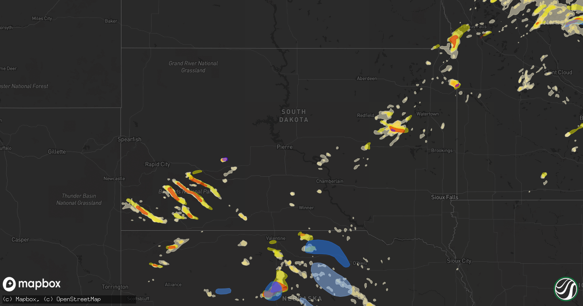
Hail Map in South Dakota on July 8, 2020
Get this storm
July 8 map
$229
one time, instant access
Download today. No call, no setup
Keep the $229
Bought the map and want the full workflow? Apply the entire $229 to a subscription within 7 days. None of it is wasted.
Every map, not just this one
This buys you this map. Subscription and you get every map we run, in the markets you choose from a few cities to whole states to nationwide. Plus real-time alerts the moment a storm fires.
Contact data
Name, contact info, occupancy, even credit band for addresses in the footprint. You go from where it hit to who to call.
Become the source they trust
Unlimited branding weather history reports on demand. You already have the documented answer ready for the property owner, and you are the one who showed up with it.
Property data and RoofTrace estimates
Pull up any address you have got, its value and the exact code rules for that jurisdiction, straight from One Click Code. Then RoofTrace estimates the squares, pitch, and roof value, priced the way you price.
Storm reports in South Dakota
South Dakota
| Date | Description |
|---|---|
| 07/08/20206:36 AM CDT | At 1136 PM CDT, a severe thunderstorm was located over Lamars, or 23 miles south of Wahpeton, moving east at 25 mph. HAZARD...60 mph wind gusts and quarter size hail. SOURCE...Radar indicated. IMPACT...Hail damage to vehicles is expected. Expect wind damage to roofs, siding, and trees. Locations impacted include... Nashua, Lamars and Blackmer. |
| 07/08/20206:21 AM CDT | At 1120 PM CDT, a severe thunderstorm was located over Lagoona Beach, or near Ortonville, moving east at 10 mph. HAZARD...60 mph wind gusts and half dollar size hail. SOURCE...Radar indicated. IMPACT...Hail damage to vehicles is expected. Expect wind damage to roofs, siding, and trees. This severe thunderstorm will be near... Clinton around 1140 PM CDT. |
| 07/08/20206:15 AM CDT | At 1115 PM CDT, a severe thunderstorm was located near Raymond, or 10 miles northwest of Clark, moving northeast at 20 mph. HAZARD...60 mph wind gusts and quarter size hail. SOURCE...Radar indicated. IMPACT...Hail damage to vehicles is expected. Expect wind damage to roofs, siding, and trees. This severe thunderstorm will be near... Crocker around 1135 PM CDT. Bradley around 1145 PM CDT. Lily around 1150 PM CDT. Butler and Swan Lake around 1155 PM CDT. Antelope Lake around 1200 AM CDT. |
| 07/08/20206:11 AM CDT | At 1110 PM CDT, a severe thunderstorm was located over Rush Lake, or near Webster, moving northeast at 20 mph. HAZARD...60 mph wind gusts and quarter size hail. SOURCE...Radar indicated. IMPACT...Hail damage to vehicles is expected. Expect wind damage to roofs, siding, and trees. This severe thunderstorm will be near... Minnewasta Lake around 1115 PM CDT. Waubay, Waubay Lake and Blue Dog Lake around 1120 PM CDT. Ortley, Grenville and Waubay Wildlife Rec Area around 1125 PM CDT. Campbell Slough and Enemy Swim Housing around 1130 PM CDT. Enemy Swim Lake and Pickerel Lake Rec Area around 1135 PM CDT. Rudebusch Corner around 1140 PM CDT. Finley Heights Housing around 1145 PM CDT. |
| 07/08/20206:06 AM CDT | A local report indicates 1.75 inch wind near 3 W OELRICHS |
| 07/08/20205:52 AM CDT | At 1052 PM CDT, a severe thunderstorm was located near New Effington, or 29 miles southwest of Wahpeton, moving northeast at 25 mph. HAZARD...60 mph wind gusts and quarter size hail. SOURCE...Radar indicated. IMPACT...Hail damage to vehicles is expected. Expect wind damage to roofs, siding, and trees. This severe thunderstorm will be near... Hankinson around 1115 PM CDT. Lamars around 1120 PM CDT. Sonora around 1125 PM CDT. Great Bend around 1130 PM CDT. Fairmount around 1135 PM CDT.This includes Interstate 29 between mile markers 0 and 16. |
| 07/08/20205:51 AM CDT | At 1050 PM CDT, a severe thunderstorm was located near New Effington, or 19 miles north of Sisseton, moving northeast at 20 mph. HAZARD...60 mph wind gusts and quarter size hail. SOURCE...Radar indicated. IMPACT...Hail damage to vehicles is expected. Expect wind damage to roofs, siding, and trees. This severe thunderstorm will remain over mainly rural areas of north central Roberts County. |
| 07/08/20205:46 AM CDT | At 1046 PM CDT, severe thunderstorms were located along a line extending from near Hitchcock to Virgil, and another line from Willow Lake to Iroquois moving northeast at 25 mph. HAZARD...60 mph wind gusts and quarter size hail. SOURCE...Radar indicated. IMPACT...Hail damage to vehicles is expected. Expect wind damage to roofs, siding, and trees. Locations impacted include... Huron, Lake Thompson State Recreation Area, De Smet, Lake Preston, Wolsey, Alpena, Iroquois, Cavour, Yale, Virgil, Erwin, Broadland and Bancroft. |
| 07/08/20205:33 AM CDT | A local report indicates 2.00 inch wind near 9 NNW PHILIP |
| 07/08/20205:32 AM CDT | At 1032 PM CDT, a severe thunderstorm was located near Hillside Colony, or 15 miles southwest of Clark, moving northeast at 20 mph. HAZARD...60 mph wind gusts and quarter size hail. SOURCE...Radar indicated. IMPACT...Hail damage to vehicles is expected. Expect wind damage to roofs, siding, and trees. This severe thunderstorm will be near... Clark Colony around 1035 PM CDT. Fordham Colony around 1040 PM CDT. Raymond around 1055 PM CDT. Clark around 1105 PM CDT. Hillcrest Colony around 1110 PM CDT. |
| 07/08/20205:32 AM CDT | At 1032 PM CDT, a severe thunderstorm was located over Wolsey, or 14 miles west of Huron, moving northeast at 30 mph. HAZARD...60 mph wind gusts and quarter size hail. SOURCE...Radar indicated. IMPACT...Hail damage to vehicles is expected. Expect wind damage to roofs, siding, and trees. This severe thunderstorm will be near... Wolsey around 1040 PM CDT.Other locations impacted by this severe thunderstorm includeBroadland. |
| 07/08/20205:30 AM CDT | At 1030 PM CDT, a severe thunderstorm was located near Odessa, or near Ortonville, moving east at 10 mph. HAZARD...60 mph wind gusts and half dollar size hail. SOURCE...Radar indicated. IMPACT...Hail damage to vehicles is expected. Expect wind damage to roofs, siding, and trees. This severe thunderstorm will remain over mainly rural areas of central Big Stone, southeastern Roberts and northeastern Grant Counties. |
| 07/08/20205:26 AM CDT | At 1025 PM CDT, a severe thunderstorm was located near Clark, moving northeast at 20 mph. HAZARD...60 mph wind gusts and quarter size hail. SOURCE...Radar indicated. IMPACT...Hail damage to vehicles is expected. Expect wind damage to roofs, siding, and trees. This severe thunderstorm will be near... Naples around 1035 PM CDT. |
| 07/08/20205:15 AM CDT | Mostly pea size hail... But some as large as quarters. Also had about 2 inches of rain in 30 minutes. |
| 07/08/20205:12 AM CDT | A local report indicates 1.25 inch wind near 1 NW MANDERSON |
| 07/08/20205:02 AM CDT | At 1002 PM CDT, a severe thunderstorm was located near Wessington Springs, or 22 miles southwest of Huron, moving northeast at 40 mph. HAZARD...60 mph wind gusts and quarter size hail. SOURCE...Radar indicated. IMPACT...Hail damage to vehicles is expected. Expect wind damage to roofs, siding, and trees. This severe thunderstorm will be near... Lane around 1005 PM CDT. Alpena around 1015 PM CDT. Virgil around 1020 PM CDT. Huron around 1040 PM CDT. Cavour around 1045 PM CDT. |
| 07/08/20204:56 AM CDT | At 956 PM CDT, a severe thunderstorm was located over Lagoona Beach, or near Ortonville, moving northeast at 30 mph. HAZARD...Two inch hail and 60 mph wind gusts. SOURCE...Radar indicated. IMPACT...People and animals outdoors will be injured. Expect hail damage to roofs, siding, windows, and vehicles. Expect wind damage to roofs, siding, and trees. This severe thunderstorm will be near... Artichoke around 1020 PM CDT. Johnson around 1025 PM CDT. |
| 07/08/20204:56 AM CDT | Hail damage to vehicles |
| 07/08/20204:47 AM CDT | At 946 PM CDT, a severe thunderstorm was located 9 miles southwest of Carpenter, or 16 miles northeast of Huron, moving east at 25 mph. HAZARD...60 mph wind gusts and quarter size hail. SOURCE...Radar indicated. IMPACT...Hail damage to vehicles is expected. Expect wind damage to roofs, siding, and trees. This severe thunderstorm will remain over mainly rural areas of northwestern Kingsbury and northeastern Beadle Counties. |
| 07/08/20204:41 AM CDT | At 940 PM CDT, a severe thunderstorm was located near Carpenter, or 18 miles southwest of Clark, moving east at 20 mph. HAZARD...Golf ball size hail and 60 mph wind gusts. SOURCE...Radar indicated. IMPACT...People and animals outdoors will be injured. Expect hail damage to roofs, siding, windows, and vehicles. Expect wind damage to roofs, siding, and trees. This severe thunderstorm will be near... Carpenter around 945 PM CDT. Fordham Colony around 955 PM CDT. |
| 07/08/20204:25 AM CDT | At 925 PM CDT, a severe thunderstorm was located 7 miles east of Fordham Colony, or 10 miles south of Clark, moving northeast at 15 mph. HAZARD...60 mph wind gusts and quarter size hail. SOURCE...Radar indicated. IMPACT...Hail damage to vehicles is expected. Expect wind damage to roofs, siding, and trees. This severe thunderstorm will be near... Clark around 1005 PM CDT. Hillcrest Colony around 1015 PM CDT. |
| 07/08/20204:07 AM CDT | A local report indicates 1.00 inch wind near KYLE |
| 07/08/20204:04 AM CDT | At 904 PM CDT, a severe thunderstorm was located near Hillside Colony, or 20 miles east of Redfield, moving northeast at 30 mph. HAZARD...60 mph wind gusts and quarter size hail. SOURCE...Radar indicated. IMPACT...Hail damage to vehicles is expected. Expect wind damage to roofs, siding, and trees. This severe thunderstorm will be near... Doland around 915 PM CDT. Clark Colony around 920 PM CDT. Fordham Colony around 925 PM CDT. Raymond around 935 PM CDT. Clark around 945 PM CDT. |
| 07/08/20203:25 AM CDT | A local report indicates 1.25 inch wind near 15 SSW FOLSOM |
| 07/08/20203:10 AM CDT | A local report indicates 1.00 inch wind near 6 NE POTATO CREEK |
| 07/08/20202:46 AM CDT | A local report indicates 1.00 inch wind near 6 SE FOLSOM |
| 07/08/20202:10 AM CDT | A local report indicates 1.00 inch wind near 13 S WALL |
| 07/08/20201:40 AM CDT | Delayed report. Winds estimated 40-50 mph with approximately 0.25 inches of rain. |
| 07/08/20201:26 AM CDT | At 626 PM MDT, severe thunderstorms were located along a line extending from 6 miles southwest of White Clay to near Hay Springs, moving northeast at 25 mph. HAZARD...60 mph wind gusts and quarter size hail. SOURCE...Radar indicated. IMPACT...Hail damage to vehicles is expected. Expect wind damage to roofs, siding, and trees. Locations impacted include... Gordon, Rushville, Hay Springs, White Clay, Clinton, Intersection of Highway 87 and Craven Creek Road, Lone Butte, Intersection of Beaver Creek Road and White Clay Creek Road, Intersection of Highway 87 and Larabee Road, Mount Maria, Highway 250 crossing the Niobrara River, Walgren Lake State Recreation Area, Pine Ridge, Metcalf State Wildlife Management Area and Intersection of Highway 87 and Antelope Road.This includes the following highways... Highway 20 between mile markers 74 and 105. Highway 250 between mile markers 34 and 48. |
| 07/08/202012:36 AM CDT | At 536 PM MDT, severe thunderstorms were located along a line extending from near Chadron to near Hemingford, moving east at 25 mph. HAZARD...70 mph wind gusts and ping pong ball size hail. SOURCE...Radar indicated. IMPACT...People and animals outdoors will be injured. Expect hail damage to roofs, siding, windows, and vehicles. Expect considerable tree damage. Wind damage is also likely to mobile homes, roofs, and outbuildings. Locations impacted include... Chadron, Crawford, Hemingford, Wild Horse Butte, Whitney Lake, Box Butte Campground, Red Cloud Campground, Box Butte Dam, Chadron Campground, Chadron Airport, Flahertys Corner, Whitney, Marsland, Chadron St Park and Fort Robinson. |
| 07/08/202012:00 AM CDT | At 500 AM CDT, a severe thunderstorm was located over White Rock, or 25 miles south of Wahpeton, moving east at 25 mph. HAZARD...60 mph wind gusts and penny size hail. SOURCE...Radar indicated. IMPACT...Expect damage to roofs, siding, and trees. This severe thunderstorm will be near... Norcross around 540 AM CDT. Herman around 545 AM CDT. Barrett and Elbow Lake around 600 AM CDT.This includes Interstate 94 in Minnesota between mile markers 63 and80. |
| 07/07/202011:23 PM CDT | At 423 AM CDT, a severe thunderstorm was located near Oakes, or 56 miles south of Valley City, moving northeast at 65 mph. HAZARD...60 mph wind gusts and quarter size hail. SOURCE...Radar indicated. IMPACT...Hail damage to vehicles is expected. Expect wind damage to roofs, siding, and trees. This severe thunderstorm will be near... Straubville around 425 AM CDT. Crete around 430 AM CDT. Stirum and Cogswell around 435 AM CDT. Gwinner and Forman around 440 AM CDT. Milnor around 450 AM CDT. |
| 07/07/202010:58 PM CDT | At 358 AM CDT, severe thunderstorms were located along a line extending from 8 miles east of Kent to 6 miles north of New Effington, moving east at 50 mph. HAZARD...60 mph wind gusts and nickel size hail. SOURCE...Radar indicated. IMPACT...Expect damage to roofs, siding, and trees. Severe thunderstorms will be near... Lawndale around 405 AM CDT. Lamars and Rothsay around 410 AM CDT. Blackmer and Carlisle around 415 AM CDT. Erhard and Elizabeth around 420 AM CDT. Southwestern Lake Lida and Tenney around 425 AM CDT.Other locations impacted by these severe thunderstorms include FergusFalls Airport.This includes the following highways... Interstate 29 between mile markers 0 and 46. Interstate 94 in Minnesota between mile markers 29 and 80. |
| 07/07/202010:55 PM CDT | Delayed report. A couple 6-8 inch diameter tree branches down due to the strong winds. |
| 07/07/202010:46 PM CDT | Delayed report. Public estimates 60 mph wind gust as the strong winds displaced silo dump wagons. |
| 07/07/202010:45 PM CDT | Nickle to quarter hail... Car damage from hail. |
| 07/07/202010:30 PM CDT | Time estimated by radar and relayed social media report via nws employee. |
| 07/07/202010:22 PM CDT | At 322 AM CDT, severe thunderstorms were located along a line extending from Kindred to 6 miles south of Geneseo, moving east at 50 mph. HAZARD...60 mph wind gusts and penny size hail. SOURCE...Radar indicated. IMPACT...Expect damage to roofs, siding, and trees. Severe thunderstorms will be near... Kindred and Davenport around 325 AM CDT. Oxbow, Hickson and Comstock around 335 AM CDT. Hankinson around 345 AM CDT. Baker and Downer around 350 AM CDT. Barnesville, Lamars and Sonora around 355 AM CDT.This includes the following highways... Interstate 29 between mile markers 0 and 56. Interstate 94 in Minnesota between mile markers 15 and 38. |
| 07/07/202010:10 PM CDT | Delayed report. 3-4 inch diameter tree branch fell down in their yard. |
| 07/07/20209:50 PM CDT | A local report indicates 1.75 inch wind near CARPENTER |
| 07/07/20209:24 PM CDT | Radar estimated time. |
| 07/07/20209:00 PM CDT | Mesonet station 244 sd rwis ft. Randall dam. |
All States Impacted by Hail Map on July 8, 2020
Cities Impacted by Hail Map on July 8, 2020
- Alborn, MN
- Lake Norden, SD
- Lake Preston, SD
- Erwin, SD
- Kenton, OH
- Rushsylvania, OH
- Ridgeway, OH
- Weldon, IL
- Olla, LA
- Brookston, MN
- Saginaw, MN
- Bolton Landing, NY
- Huletts Landing, NY
- Hague, NY
- Kingman, IN
- Bloomingdale, IN
- Morristown, MN
- Puposky, MN
- Shevlin, MN
- Motley, MN
- Pillager, MN
- Ortonville, MN
- Long Pine, NE
- Arthur, NE
- Aurora, NE
- Hunter, KS
- Kadoka, SD
- Isle, MN
- Mora, MN
- Charlestown, NH
- Alstead, NH
- Acworth, NH
- South Acworth, NH
- Putney, VT
- Geneva, NE
- Ohiowa, NE
- Milligan, NE
- Exeter, NE
- Fairmont, NE
- Grant Park, IL
- Clay Center, KS
- Minneapolis, KS
- Solomon, KS
- Hope, KS
- Longford, KS
- Talmage, KS
- Miltonvale, KS
- Abilene, KS
- Enterprise, KS
- Lincoln, KS
- Kevil, KY
- Big Stone City, SD
- Clinton, MN
- Corona, SD
- Sumner, IL
- Claremont, IL
- Brainerd, MN
- Wheaton, MN
- Estelline, SD
- Clear Lake, SD
- Loda, IL
- Hampton, MN
- Vermillion, MN
- Hastings, MN
- Lance Creek, WY
- Oconto, NE
- Solon Springs, WI
- New London, MN
- Goodland, MN
- Brook Park, MN
- Hudson, WI
- River Falls, WI
- Valentine, NE
- Bassett, NE
- Ainsworth, NE
- Ogema, MN
- Canyon, MN
- Stillwater, NY
- Belgrade, NE
- Saint Edward, NE
- Fullerton, NE
- Cedar Rapids, NE
- Albion, NE
- Wolbach, NE
- Hanover, KS
- Hollenberg, KS
- Washington, KS
- Faribault, MN
- Edgemont, SD
- Farmington, ME
- Philip, SD
- Whitney, NE
- Ashton, NE
- Oberlin, KS
- Bagley, MN
- Bemidji, MN
- Solway, MN
- Leonard, MN
- North Platte, NE
- Paynesville, MN
- Spicer, MN
- Belgrade, MN
- Sebeka, MN
- Backus, MN
- Staples, MN
- Hinckley, MN
- Wilsonville, NE
- Park Rapids, MN
- Hackensack, MN
- Walker, MN
- Gordon, WI
- Sarona, WI
- Spooner, WI
- Shell Lake, WI
- Wood Lake, NE
- Johnstown, NE
- Hazard, NE
- Paris, IL
- Concordia, KS
- Stockville, NE
- Monticello, IL
- De Land, IL
- Henderson, MN
- Perham, MN
- Frazee, MN
- Henning, IL
- Rossville, IL
- Bloomer, WI
- Chippewa Falls, WI
- Hot Springs, SD
- Derby, KS
- Haysville, KS
- Mason, WI
- Carpenter, SD
- Parks, NE
- Martin, SD
- Tuthill, SD
- Cottage Grove, MN
- Culbertson, NE
- McCook, NE
- Lake Nebagamon, WI
- Brule, WI
- Jordan, MN
- Shakopee, MN
- Eustis, NE
- Elsie, NE
- Centerville, IN
- Richmond, IN
- Cody, NE
- Graytown, OH
- Elmore, OH
- Oak Harbor, OH
- Nevis, MN
- Kimball, NE
- Peetz, CO
- Padroni, CO
- Blackduck, MN
- Wilmot, SD
- Paradise, KS
- Natoma, KS
- Jonesville, LA
- Mankato, KS
- Glen Elder, KS
- Beloit, KS
- Poplar, WI
- Aitkin, MN
- Arapahoe, NE
- Elwood, NE
- Wood River, NE
- Prospect, KY
- Goshen, KY
- Menahga, MN
- Mcgregor, MN
- Tamarack, MN
- Frederic, WI
- Moorefield, NE
- Grand Rapids, MN
- Swatara, MN
- Hill City, MN
- Remer, MN
- Scenic, SD
- Jim Falls, WI
- Cadott, WI
- Thedford, NE
- Gregory, SD
- Hay Springs, NE
- Rushville, NE
- Pine Ridge, SD
- Fairburn, SD
- South Haven, MN
- Watkins, MN
- Dassel, MN
- Kimball, MN
- Cornell, WI
- Cook, MN
- Hendley, NE
- Siren, WI
- Buffalo Gap, SD
- Winfield, PA
- Freeburg, PA
- Middleburg, PA
- Selinsgrove, PA
- Salem, IN
- Crosby, MN
- Lyons, KS
- Fair Haven, VT
- Whitehall, NY
- Ponsford, MN
- Kettle River, MN
- Cromwell, MN
- Spalding, NE
- David City, NE
- Clark, SD
- Willow Lake, SD
- Raymond, SD
- Ely, MN
- Marsland, NE
- Hemingford, NE
- Shelby, NE
- Mason City, NE
- Phillips, ME
- Tiro, OH
- Crestline, OH
- Davenport, NE
- Clifton, TN
- Osage, MN
- Crawfordsville, IN
- Bena, MN
- Champion, NE
- Walpole, NH
- Marenisco, MI
- Ewen, MI
- Bergland, MI
- Bruce Crossing, MI
- Pelican Rapids, MN
- Round Lake, NY
- Mechanicville, NY
- Clifton Park, NY
- Ballston Spa, NY
- Ballston Lake, NY
- Waldo, KS
- Osborne, KS
- South Range, WI
- Maple, WI
- Beecher, IL
- Crete, IL
- Cambridge, NE
- Pequot Lakes, MN
- Nisswa, MN
- Oxford, NE
- Edison, NE
- Holbrook, NE
- Avon, MN
- Milton, VT
- Colchester, VT
- Dix, NE
- Hermosa, SD
- Jewell, KS
- Randall, KS
- Cushing, MN
- Henning, MN
- Amelia, NE
- Trenton, NE
- Dieterich, IL
- Wheeler, IL
- Newton, IL
- Wrenshall, MN
- Bartlett, NE
- Odessa, MN
- Seneca, NE
- Stone Lake, WI
- Springbrook, WI
- Springview, NE
- Baxter, MN
- Wanblee, SD
- Midland, SD
- Westmoreland, NH
- Keene, NH
- Westminster, VT
- Richmond, VT
- Jericho, VT
- Williston, VT
- New Cambria, KS
- Salina, KS
- Gentryville, IN
- Tennyson, IN
- Gaastra, MI
- Caspian, MI
- Iron River, MI
- Sturgeon Lake, MN
- Palisade, MN
- Zimmerman, MN
- Saint Francis, MN
- Lower Brule, SD
- Sherburn, MN
- Otis, KS
- Naper, NE
- Cozad, NE
- Bloomington, NE
- Scottsburg, IN
- Hillsboro, KS
- Newton, KS
- Holyoke, MN
- Center Sandwich, NH
- Holderness, NH
- Center Harbor, NH
- Moultonborough, NH
- Alda, NE
- Grand Island, NE
- New Underwood, SD
- Melrose, MN
- Minneapolis, MN
- Delphos, KS
- Tunkhannock, PA
- Doland, SD
- Clemons, NY
- Wood, SD
- Winner, SD
- Kyle, SD
- Allen, SD
- Rangeley, ME
- Burwell, NE
- Huron, SD
- Hitchcock, SD
- Belleville, IL
- East Saint Louis, IL
- Fairfax, SD
- Crawford, NE
- Detroit, MI
- Highland Park, MI
- Alton, KS
- Keyesport, IL
- Carlyle, IL
- Greenville, IL
- Cotton, MN
- Duluth, MN
- Oneill, NE
- Ericson, NE
- Olmstead, KY
- Luck, WI
- Grantsburg, WI
- Cushing, WI
- Battle Lake, MN
- Dalton, MN
- Waterville, MN
- Port Wing, WI
- Eldridge, IA
- Davenport, IA
- Frankfort, SD
- Clay City, IL
- Osseo, WI
- Fairchild, WI
- Oakdale, NE
- Elgin, NE
- Chisago City, MN
- Stacy, MN
- Lindstrom, MN
- Indianapolis, IN
- Sisseton, SD
- Mondovi, WI
- Eleva, WI
- Strang, NE
- New York Mills, MN
- Saint James, MN
- Superior, WI
- Thorp, WI
- Gordon, NE
- Pecatonica, IL
- Winnebago, IL
- Leaf River, IL
- Deerwood, MN
- Correctionville, IA
- Anthon, IA
- Chase, KS
- Bushton, KS
- Sterling, KS
- Geneseo, KS
- Little River, KS
- Lorraine, KS
- Sutton, NE
- Grafton, NE
- Waverly, MN
- Howard Lake, MN
- Surprise, NE
- Rising City, NE
- Moose Lake, MN
- Long Lake, WI
- Crystal Falls, MI
- Oconee, IL
- Republican City, NE
- Naponee, NE
- Kerrick, MN
- Minong, WI
- Pine River, MN
- Doniphan, NE
- Florence, SD
- Henry, SD
- Roberts, WI
- Clearwater, NE
- Ewing, NE
- Norway, KS
- Jamestown, KS
- Bunker Hill, KS
- Cleveland, MN
- Pfeifer, KS
- Hays, KS
- Webster, WI
- Bradley, SD
- Kokomo, IN
- Center Barnstead, NH
- Barnstead, NH
- West Forks, ME
- Summit, SD
- Thornton, NH
- Campton, NH
- Anselmo, NE
- Carlton, MN
- Barnum, MN
- Poultney, VT
- Wells, VT
- Middletown Springs, VT
- Tintah, MN
- Rosholt, SD
- Campbell, MN
- Fairmount, ND
- Drummond, WI
- Ottertail, MN
- Bingham, NE
- Ashby, NE
- Greenwood, IN
- Bargersville, IN
- Mount Juliet, TN
- Lebanon, TN
- Murfreesboro, TN
- Smyrna, TN
- Cedar Grove, TN
- Esko, MN
- Ridge Farm, IL
- Chrisman, IL
- Garrison, MN
- Alpena, SD
- Greeley, NE
- Chambers, NE
- Primrose, NE
- Kensington, KS
- North Vernon, IN
- Taswell, IN
- Floodwood, MN
- Wilber, NE
- Onamia, MN
- Hillman, MN
- Ironton, MN
- Almena, KS
- Beaver City, NE
- Bowlus, MN
- Holdingford, MN
- Benkelman, NE
- Cass Lake, MN
- Cold Spring, MN
- Saint Joseph, MN
- Saint Cloud, MN
- Silver Lake, IN
- New Ross, IN
- Phillipsburg, KS
- Agra, KS
- Webster, SD
- Russell, KS
- Rockville, IN
- Waveland, IN
- Marshall, IN
- Rochert, MN
- Detroit Lakes, MN
- Iroquois, SD
- Palmer, NE
- Wellfleet, NE
- Maywood, NE
- Waubay, SD
- Chadron, NE
- Fort Wayne, IN
- Dannebrog, NE
- Lebanon, NE
- Bartley, NE
- Danbury, NE
- Indianola, NE
- Cogan Station, PA
- Trout Run, PA
- Ideal, SD
- Wallingford, VT
- Dearborn, MI
- Crofton, KY
- Dawson Springs, KY
- Saint Charles, KY
- Wall, SD
- Manderson, SD
- Talmoon, MN
- Bigfork, MN
- Braham, MN
- Gothenburg, NE
- Monterey, LA
- Celina, OH
- Coldwater, OH
- Rumford, ME
- Curtice, OH
- Millbury, OH
- Bushnell, NE
- Wapakoneta, OH
- Lakewood, IL
- Cowden, IL
- Tower Hill, IL
- Montrose, MN
- Buffalo, MN
- Macy, IN
- Fort Recovery, OH
- Formoso, KS
- Ellsworth, KS
- Browerville, MN
- Merrifield, MN
- New Effington, SD
- Arlington, SD
- Hampton, NY
- Callaway, MN
- Appleton, MN
- Correll, MN
- Bruce, WI
- Bethlehem, IN
- New Washington, IN
- Saint Joseph, IL
- Brady, NE
- Riverton, NE
- Tescott, KS
- Beardsley, MN
- Annandale, MN
- Ravenna, NE
- Hurley, WI
- Mercer, WI
- Genoa, NE
- Wolsey, SD
- Arkansas City, KS
- Iron River, WI
- Wadena, MN
- Hayti, SD
- Alma, WI
- Belle Plaine, MN
- Fifty Lakes, MN
- Crosslake, MN
- Emily, MN
- Hammond, WI
- Baldwin, WI
- Hastings, NE
- Wilton, ME
- Shelby, OH
- Tell City, IN
- Vergas, MN
- Webber, KS
- Wright, MN
- Ontonagon, MI
- Imperial, NE
- Crestwood, KY
- Phelps, WI
- Ojibwa, WI
- Taylor, NE
- Loup City, NE
- Wildersville, TN
- Clearbrook, MN
- Isanti, MN
- Pine City, MN
- Mellen, WI
- Centuria, WI
- Milltown, WI
- Purdum, NE
- Chapman, KS
- Colwich, KS
- Mount Hope, KS
- Conover, WI
- Land O'Lakes, WI
- Highmore, SD
- Hankinson, ND
- English, IN
- Beaver Crossing, NE
- Mulvane, KS
- Udall, KS
- Douglass, KS
- Cerulean, KY
- Calhoun, KY
- Wessington Springs, SD
- Urbana, IL
- Clarissa, MN
- Cambridge, MN
- West Union, IL
- Saint Paul, MN
- Princeton, KY
- Oelrichs, SD
- Strum, WI
- Interior, SD
- Wilson, KS
- Fort Thompson, SD
- Phillips, NE
- Louisville, KY
- Benedict, KS
- Darlington, IN
- Morris, IL
- Channahon, IL
- Minooka, IL
- Swanton, NE
- De Witt, NE
- York, PA
- Center City, MN
- Maxwell, NE
- Hillsboro, IN
- Alamo, IN
- Waynetown, IN
- Berne, IN
- Geneva, IN
- Jacobson, MN
- Cloquet, MN
- Foxboro, WI
- Brooten, MN
- Sauk Centre, MN
- Stamford, NE
- Bedford, IN
- Longville, MN
- Abbyville, KS
- Newman Grove, NE
- Sandstone, MN
- Saint Croix Falls, WI
- North Branch, MN
- Nashwauk, MN
- Trego, WI
- Star Prairie, WI
- Deer Park, WI
- Amery, WI
- New Richmond, WI
- Dunning, NE
- Nickerson, KS
- Outing, MN
- Townshend, VT
- Chester, VT
- Millstadt, IL
- Byron, IL
- Sedgwick, KS
- Burrton, KS
- Minocqua, WI
- Sutherland, NE
- Lewisburg, PA
- Madison, MN
- Bellingham, MN
- Tampa, KS
- Noble, IL
- Cokato, MN
- Frenchboro, ME
- Brule, NE
- Cisne, IL
- West York, IL
- Watersmeet, MI
- Strong City, KS
- Cottonwood Falls, KS
- Elmdale, KS
- Yale, SD
- Mount Pleasant Mills, PA
- Stanchfield, MN
- Grandy, MN
- Prescott, WI
- Willard, WI
- Humbird, WI
- Guide Rock, NE
- Windsor, IL
- Mehoopany, PA
- Sugar Run, PA
- Hardinsburg, IN
- Paoli, IN
- Durham, KS
- Pelkie, MI
- Sergeant Bluff, IA
- Sioux City, IA
- Glasco, KS
- Vining, MN
- Parkers Prairie, MN
- Oblong, IL
- Maize, KS
- Wichita, KS
- Lewisville, MN
- Giltner, NE
- Carleton, NE
- Bluffton, MN
- Deer Creek, MN
- Finlayson, MN
- Pierz, MN
- Akeley, MN
- Verndale, MN
- Wahkon, MN
- McGrath, MN
- Naytahwaush, MN
- Mahnomen, MN
- Waubun, MN
- Robinson, IL
- Palisade, NE
- Grand View, WI
- Williamsport, PA
- Montoursville, PA
- Smith Center, KS
- Athol, KS
- Plainville, KS
- Dunnville, KY
- Phillips, WI
- Gaylord, KS
- Augusta, WI
- Woodbine, KS
- Herington, KS
- Mentone, IN
- Gibbon, NE
- Aurora, KS
- White Plains, KY
- Spencerville, OH
- Homer, IL
- Sidney, IL
- Swanzey, NH
- Waterville, KS
- Orchard, NE
- Winnetoon, NE
- Fergus Falls, MN
- Underwood, MN
- Albany, MN
- Thorntown, IN
- Dumont, MN
- Hershey, NE
- Ashland, WI
- Earlville, NY
- Hamilton, NY
- Osceola, NE
- Deweese, NE
- Fairfield, NE
- Fall Creek, WI
- Independence, WI
- Washta, IA
- Pierson, IA
- Vienna, SD
- Halsey, NE
- Evanston, IN
- Saint Meinrad, IN
- Bedford, KY
- Milton, KY
- Jamestown, IN
- Marengo, IN
- Le Center, MN
- Oral, SD
- Ord, NE
- Bellwood, NE
- Friend, NE
- Northome, MN
- Downs, KS
- Cawker City, KS
- Esbon, KS
- Lanse, MI
- Eagle Bend, MN
- Columbia, IL
- Browns Valley, MN
- Freeport, MN
- Sargent, NE
- North Judson, IN
- Carver, MN
- Sheboygan, WI
- Curtis, NE
- Alma, NE
- Orleans, NE
- Lehigh, KS
- Geddes, SD
- Rockville, NE
- Tipton, IN
- Plevna, KS
- Truman, MN
- Harris, MN
- Rush City, MN
- Bourbonnais, IL
- Hayes Center, NE
- Brooklyn, IN
- Martinsville, IN
- Monrovia, IN
- Mooresville, IN
- Rinard, IL
- Fairmont, MN
- Geneseo, IL
- Hewitt, MN
- Swanton, VT
- Wessington, SD
- Mcpherson, KS
- Inman, KS
- Mills, NE
- Armstrong Creek, WI
- Goodman, WI
- Royalton, MN
- Butte, NE
- Bonesteel, SD
- Lebanon, KS
- Canton, KS
- Cairo, NE
- Colfax, WI
- West Terre Haute, IN
- Tower, MN
- Silver Creek, NE
- Bryant, SD
- Jay, ME
- Dixfield, ME
- Eden Prairie, MN
- Swan River, MN
- Warba, MN
- High Bridge, WI
- Bluffton, IN
- Wyoming, MN
- Herrick, SD
- Castlewood, SD
- Luckey, OH
- Woodville, OH
- Oglala, SD
- Deer River, MN
- Arcadia, NE
- Calhoun, IL
- Moundridge, KS
- Sylvan Grove, KS
- Gilmanton, NH
- Belmont, NH
- Fairbury, NE
- Cicero, IN
- Noblesville, IN
- Effie, MN
- Orr, MN
- Kelliher, MN
- Homer, NE
- Mullen, NE
- Walton, IN
- Whitman, NE
- Boyceville, WI
- Boelus, NE
- Oak, NE
- Lake George, MN
- Laporte, MN
- Verdigre, NE
- Elkton, KY
- Guthrie, KY
- Allensville, KY
- Madison, IN
- Moran, KS
- Beech Grove, IN
- Dresser, WI
- Osceola, WI
- Buckley, IL
- Melvin, IL
- Paxton, IL
- Bennington, KS
- Makinen, MN
- North Loup, NE
- Diller, NE
- Pulaski, TN
- Waterbury, VT
- La Crosse, IN
- Strasburg, IL
- Gilmanton Iron Works, NH
- Alliance, NE
- Knapp, WI
- Strafford, NH
- Otego, NY
- Hayward, WI
- Lopez, PA
- Mildred, PA
- Dushore, PA
- Montezuma, IN
- Clear Lake, WI
- Clayton, WI
- Hagerstown, IN
- Holyrood, KS
- Peever, SD
- Bertha, MN
- Balsam Lake, WI
- Long Grove, IA
- Donahue, IA
- Essex Junction, VT
- Claremont, NH
- Wounded Knee, SD
- Marshall, IL
- Dorchester, NE
- Western, NE
- New Vineyard, ME
- Strong, ME
- Woodston, KS
- Rocky Ridge, OH
- Redlake, MN
- Redby, MN
- Salem, MO
- Virginia, MN
- Nortonville, KY
- Marlborough, NH
- Troy, NH
- Jaffrey, NH
- Litchfield, NE
- Windsor, KY
- Rice Lake, WI
- Cameron, WI
- Saratoga Springs, NY
- Shelton, NE
- Foxhome, MN
- Breckenridge, MN
- Bertrand, NE
- Trout Creek, MI
- Silver Bay, NY
- Plymouth, NE
- Winter, WI
- Hines, MN
- Bethlehem, NH
- Aldrich, MN
- Princeton, MN
- Shickley, NE
- Julesburg, CO
- Venango, NE
- Trumbull, NE
- Glenvil, NE
- Lawrence, NE
- Le Sueur, MN
- Inman, NE
- Savannah, TN
- Courtland, KS
- Atkinson, NE
- Brewster, NE
- Dyer, IN
- Saint John, IN
- Aurora, MN
- Miller, SD
- Claire City, SD
- Kearney, NE
- Marengo, WI
- Gurley, NE
- Sidney, NE
- Big Springs, NE
- Ovid, CO
- Sedgwick, CO
- Chappell, NE
- Lodgepole, NE
- Crook, CO
- Madrid, NE
- Amherst, CO
- Grant, NE
- Hyannis, NE
- Newport, NE
- Stuart, NE
- Axtell, NE
- Loomis, NE
- Franklin, NE
- Smithfield, NE
- Wilcox, NE
- Holdrege, NE
- Minden, NE
- Norton, KS
- Farnam, NE
- Inavale, NE
- Prairie View, KS
- Long Island, KS
- Dickens, NE
- Campbell, NE
- Upland, NE
- Atlanta, NE
- Funk, NE
- Hildreth, NE
- Clay Center, NE
- Wakefield, KS
- Hamilton, KS
- Gresham, NE
- Neosho Rapids, KS
- Burr, NE
- Barneston, NE
- Sprague, NE
- Auburn, NE
- Riley, KS
- Saint George, KS
- Allen, KS
- Cordova, NE
- Hampton, NE
- Goehner, NE
- Lincoln, NE
- Clarks, NE
- Pawnee City, NE
- Tobias, NE
- Marquette, NE
- Scotia, NE
- Table Rock, NE
- Liberty, NE
- Saronville, NE
- Axtell, KS
- Matfield Green, KS
- Raymond, NE
- Saint Marys, KS
- Topeka, KS
- Harvard, NE
- Holstein, NE
- Burr Oak, KS
- Unadilla, NE
- Juniata, NE
- Murdock, NE
- Red Cloud, NE
- Manhattan, KS
- Frankfort, KS
- Sterling, NE
- Leonardville, KS
- Ruskin, NE
- Home, KS
- Marysville, KS
- Clyde, KS
- Crete, NE
- Bremen, KS
- Burlingame, KS
- Filley, NE
- Ong, NE
- Olsburg, KS
- Bern, KS
- Central City, NE
- Elba, NE
- Kenesaw, NE
- Greenleaf, KS
- Council Grove, KS
- Hubbell, NE
- Munden, KS
- Blue Springs, NE
- Steele City, NE
- Malcolm, NE
- Bladen, NE
- Riverdale, NE
- Eskridge, KS
- Crab Orchard, NE
- Haddam, KS
- Cuba, KS
- Saint Paul, NE
- Bruning, NE
- Ogden, KS
- Polk, NE
- Jansen, NE
- Reynolds, NE
- Bennet, NE
- Steinauer, NE
- McFarland, KS
- Belvue, KS
- Randolph, KS
- Linn, KS
- Osage City, KS
- Archer, NE
- Morganville, KS
- Wymore, NE
- Pleasant Dale, NE
- Pleasanton, NE
- Hickman, NE
- Roca, NE
- Belvidere, NE
- Adams, NE
- Deshler, NE
- Benedict, NE
- Paxico, KS
- Edgar, NE
- Harveyville, KS
- Utica, NE
- Chester, NE
- Alexandria, NE
- Saint Libory, NE
- Comstock, NE
- Endicott, NE
- Johnson, NE
- Greenwood, NE
- Narka, KS
- Baileyville, KS
- Virgil, KS
- Morrowville, KS
- Milford, KS
- Oketo, KS
- Emporia, KS
- Avoca, NE
- Madison, KS
- Heartwell, NE
- York, NE
- Vermillion, KS
- Belleville, KS
- Clatonia, NE
- Byron, NE
- Milford, NE
- Walton, NE
- Centralia, KS
- Cortland, NE
- Nelson, NE
- Otoe, NE
- Mahaska, KS
- Seward, NE
- Lewiston, NE
- Garland, NE
- Daykin, NE
- Palmer, KS
- Pickrell, NE
- Beattie, KS
- Alma, KS
- Seneca, KS
- Eureka, KS
- Green, KS
- Odell, NE
- Tecumseh, NE
- Beatrice, NE
- Martell, NE
- Emmett, KS
- Superior, NE
- Virginia, NE
- Firth, NE
- Dunbar, NE
- Elk Creek, NE
- Junction City, KS
- Talmage, NE
- Agenda, KS
- Fort Riley, KS
- Westmoreland, KS
- Syracuse, NE
- Du Bois, NE
- Lorton, NE
- Admire, KS
- Brock, NE
- Panama, NE
- Chapman, NE
- Elmwood, NE
- Cook, NE
- Inland, NE
- Summerfield, KS
- Douglas, NE
- Corning, KS
- Onaga, KS
- Waco, NE
- Alvo, NE
- Clifton, KS
- Hartford, KS
- Gilead, NE
- McCool Junction, NE
- Blue Hill, NE
- Hardy, NE
- Olpe, KS
- Republic, KS
- Roseland, NE
- Staplehurst, NE
- Yates Center, KS
- Scandia, KS
- Ansley, NE
- Westerville, NE
- Burchard, NE
- Nebraska City, NE
- Reading, KS
- Hallam, NE
- Weeping Water, NE
- Havensville, KS
- Stromsburg, NE
- Broken Bow, NE
- Wamego, KS
- Americus, KS
- Maple Hill, KS
- Hebron, NE
- Hordville, NE
- Bradshaw, NE
- Alta Vista, KS
- Auburn, KS
- Humboldt, NE
- Barnes, KS
- Denton, NE
- Ayr, NE
- Waverly, NE
- Blue Rapids, KS
- Gridley, KS
- Henderson, NE
- Farwell, NE
- Davey, NE
- Eagle, NE
- Palmyra, NE
- Eddyville, NE
- Sumner, NE
- Miller, NE
- Lexington, NE
- Amherst, NE
- Callaway, NE
- Elsmere, NE
- Spofford, NH
- Pittsfield, NH
- Lincoln, NH
- Meredith, NH
- Yoder, IN
- Saint Albans, VT
- Fairfield, VT
- Danby, VT
- Pawlet, VT
- East Dorset, VT
- Oxford, ME
- Mount Vernon, ME
- Belgrade, ME
- Kents Hill, ME
- Ashby, MN
- Wahpeton, ND
- Prior Lake, MN
- New Prague, MN
- Oquossoc, ME
- Mexico, ME
- Andover, ME
- Roxbury, ME
- Hanover, ME
- Bethel, ME
- Buckfield, ME
- Sumner, ME
- West Paris, ME
- Peru, ME
- Bryant Pond, ME
- Tenants Harbor, ME
- Bremen, ME
- Round Pond, ME
- Damariscotta, ME
- Cushing, ME
- Waldoboro, ME
- Friendship, ME
- Bristol, ME
- Spruce Head, ME
- Whitefield, NH
- Littleton, NH
- Winchester, NH
- Upson, WI
- Butternut, WI
- Washburn, WI
- Saxon, WI
- Glidden, WI
- Danbury, WI
- Cable, WI
- Iron Belt, WI
- Clam Lake, WI


