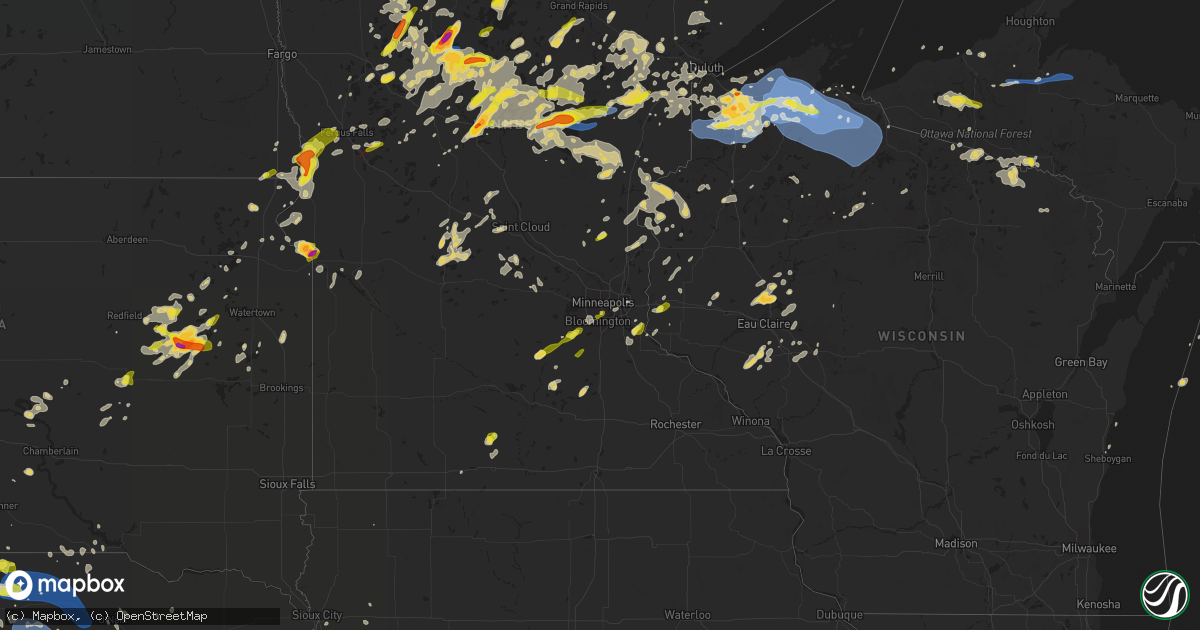
Hail Map on July 8, 2020
Get this storm
July 8 map
$229
one time, instant access
Download today. No call, no setup
Keep the $229
Bought the map and want the full workflow? Apply the entire $229 to a subscription within 7 days. None of it is wasted.
Every map, not just this one
This buys you this map. Subscription and you get every map we run, in the markets you choose from a few cities to whole states to nationwide. Plus real-time alerts the moment a storm fires.
Contact data
Name, contact info, occupancy, even credit band for addresses in the footprint. You go from where it hit to who to call.
Become the source they trust
Unlimited branding weather history reports on demand. You already have the documented answer ready for the property owner, and you are the one who showed up with it.
Property data and RoofTrace estimates
Pull up any address you have got, its value and the exact code rules for that jurisdiction, straight from One Click Code. Then RoofTrace estimates the squares, pitch, and roof value, priced the way you price.
States Impacted by Hail Map on July 8, 2020
Storm reports
Missouri
| Date | Description |
|---|---|
| 07/08/20203:22 PM CDT | Trained spotter observed a downed tree branch near harvester road and mcclay rd. Size unknown and wind gust estimated to 45 mph. |
| 07/07/202011:17 PM CDT | At 417 PM CDT, a severe thunderstorm was located 7 miles southeast of Crystal City, moving northwest at 5 mph. HAZARD...60 mph wind gusts and nickel size hail. SOURCE...Radar indicated. IMPACT...Expect damage to roofs, siding, and trees. Locations impacted include... Festus, Pevely, Crystal City, Herculaneum, Valmeyer, Olympian Village, Horine, Maeystown, Fults, Hematite, Renault, Ames, Madonnaville, Chalfin Bridge, Monroe City, Foster Pond, Harrisonville and Kidd.This includes Interstate 55 in Missouri between exits 162 and 178. This also includes Gov. Dunklin's Grave Historic Site. |
Louisiana
| Date | Description |
|---|---|
| 07/07/202010:43 PM CDT | At 343 PM CDT, severe thunderstorms were located along a line extending from near Rock Hill to 8 miles east of Varnado, moving southeast at 25 mph. HAZARD...60 mph wind gusts and penny size hail. SOURCE...Radar indicated. IMPACT...Expect damage to roofs, siding, and trees. Locations impacted include... Poplarville and Angie. |
Nebraska
| Date | Description |
|---|---|
| 07/08/20206:58 PM CDT | A local report indicates 1.00 inch wind near 12 NW SPRINGVIEW |
| 07/08/20206:58 PM CDT | Awos station k1iw india madis. |
| 07/08/20206:55 PM CDT | Landspout tornado |
| 07/08/20206:55 PM CDT | Rope tornado spotted on the ground... Increasing in intensity by volunteer fire department. |
| 07/08/20206:53 PM CDT | Landspout |
| 07/08/20206:50 PM CDT | Ph315 reported a touchdown approximately 20 ne of holyoke. |
| 07/08/20206:50 PM CDT | Landspout tornado |
| 07/08/20206:50 PM CDT | Landspout type tornado producing a dust cloud at the surface |
| 07/08/20206:39 PM CDT | A local report indicates 1.00 inch wind near 13 NW SPRINGVIEW |
| 07/08/20206:30 PM CDT | A local report indicates 60 MPH wind near 12 SE SIDNEY |
| 07/08/20206:11 PM CDT | A local report indicates 94 MPH wind near SIDNEY AIRPORT |
| 07/08/20206:11 PM CDT | Asos station ksny sidney airport. |
| 07/08/20206:05 PM CDT | A local report indicates 1.00 inch wind near 15 NNW BOBCAT STATE WIL |
| 07/08/20205:40 PM CDT | Union pacific mesonet |
| 07/08/202011:51 AM CDT | Cwop ew1566. |
| 07/08/202011:46 AM CDT | Cwop ew1566. |
| 07/08/20206:31 AM CDT | At 1131 PM CDT, severe thunderstorms were located along a line extending from near St. Paul to near Alda to near Gibbon, moving southeast at 60 mph. HAZARD...70 mph wind gusts. SOURCE...Radar indicated. IMPACT...Expect considerable tree damage. Damage is likely to mobile homes, roofs, and outbuildings. Locations impacted include... Grand Island, Hastings, York, Aurora, Central City, Geneva, Sutton, Harvard, Henderson, Doniphan, Clay Center, Juniata, Fairmont, Edgar, Hampton, McCool Junction, Fairfield, Giltner, Shickley and Glenvil.People attending Fillmore County Fairgrounds, and Clay CountyFairgrounds should seek safe shelter immediately!This includes Interstate 80 between mile markers 300 and 362. |
| 07/08/20206:06 AM CDT | At 1106 PM CDT, severe thunderstorms were located along a line extending from near Loup City to near Pleasanton, moving east at 50 mph. HAZARD...60 mph wind gusts. SOURCE...Radar indicated. IMPACT...Expect damage to roofs, siding, and trees. Locations impacted include... Grand Island, St. Paul, Gibbon, Ravenna, Wood River, Shelton, Loup City, Doniphan, Cairo, Alda, Pleasanton, Dannebrog, Litchfield, Elba, Ashton, Farwell, Rockville, Hazard, Sherman Reservoir Dam and St. Libory.This includes Interstate 80 between mile markers 290 and 315. |
| 07/08/20205:36 AM CDT | At 1036 PM CDT, severe thunderstorms were located along a line extending from 6 miles north of Albion to near Greeley to 6 miles southwest of North Loup, moving southeast at 40 mph. HAZARD...60 mph wind gusts. SOURCE...Trained weather spotters. IMPACT...Expect damage to roofs, siding, and trees. Locations impacted include... Greeley, St. Paul, Fullerton, Genoa, Spalding, Palmer, Scotia, Dannebrog, North Loup, Wolbach, Elba, Ashton, Belgrade, Farwell, Rockville, Cotesfield, Cushing, Archer, Sherman Reservoir Dam and St. Libory. |
| 07/08/20205:31 AM CDT | At 1031 PM CDT, a severe thunderstorm was located near Weissert, or 16 miles east of Broken Bow, moving southeast at 45 mph. HAZARD...60 mph wind gusts. SOURCE...Radar indicated. IMPACT...Expect damage to roofs, siding, and trees. Locations impacted include... Arcadia Diversion Dam State Wildlife Management Area. |
| 07/08/20205:28 AM CDT | At 1028 PM CDT, severe thunderstorms were located along a line extending from near Sargent to 7 miles southwest of Eddyville, moving east at 50 mph. HAZARD...60 mph wind gusts. SOURCE...Radar indicated. IMPACT...Expect damage to roofs, siding, and trees. Locations impacted include... Loup City, Pleasanton, Arcadia, Litchfield, Sumner, Miller, Eddyville, Hazard and Sherman Reservoir Dam. |
| 07/08/20205:24 AM CDT | At 1024 PM CDT, severe thunderstorms were located along a line extending from 4 miles southwest of Meadow Grove to 4 miles north of Albion to 6 miles northwest of Cedar Rapids, moving east at 45 mph. HAZARD...60 mph wind gusts and nickel size hail. SOURCE...Radar indicated. IMPACT...Expect damage to roofs, siding, and trees. Locations impacted include... Albion, Newman Grove, St. Edward, Cedar Rapids, Petersburg, Lindsay, Primrose, Loretto and The Highway 14 And 56 Junction. |
| 07/08/20205:16 AM CDT | At 1016 PM CDT, severe thunderstorms were located along a line extending from near Broken Bow to 7 miles south of Oconto, moving east at 35 mph. HAZARD...70 mph wind gusts. SOURCE...Radar indicated. IMPACT...Expect considerable tree damage. Damage is likely to mobile homes, roofs, and outbuildings. Locations impacted include... Broken Bow, Ansley, Mason City, Oconto, Berwyn, Buckeye, Block Hill Basin, Pressey State Wildlife Management Area, Burr Oak, Gavin Siding, Intersection of Highway 183 and Cumro Road and Cumro.This includes the following highways... Highway 183 between mile markers 73 and 96. Highway 2 between mile markers 274 and 307. Highway 92 between mile markers 300 and 308. |
| 07/08/20205:11 AM CDT | At 1011 PM CDT, severe thunderstorms were located along a line extending from 4 miles southeast of Edison to near Hendley to 4 miles southwest of Lebanon to near Herndon, moving southeast at 35 mph. HAZARD...60 mph wind gusts. SOURCE...Radar indicated. IMPACT...Expect damage to roofs, siding, and trees. Locations impacted include... McCook, Norton, Oberlin, Culbertson, Indianola, Almena and Bartley. |
| 07/08/20205:03 AM CDT | At 1002 PM CDT, a severe thunderstorm was located 7 miles north of Victoria Springs State Recreation Area, or 16 miles south of Brewster, moving southeast at 40 mph. HAZARD...70 mph wind gusts. SOURCE...Radar indicated. IMPACT...Expect considerable tree damage. Damage is likely to mobile homes, roofs, and outbuildings. Locations impacted include... Sargent, Merna, Comstock, Victoria Springs State Recreation Area, Weissert, Westerville, Lillian, Milburn, Round Valley, Walworth, Wescott and Gates.This includes Highway 183 between mile markers 98 and 117. |
| 07/08/20204:32 AM CDT | At 931 PM CDT, severe thunderstorms were located along a line extending from 6 miles south of Avon to 5 miles south of Verdigre, moving east at 35 mph. HAZARD...60 mph wind gusts. SOURCE...Radar indicated. IMPACT...Expect damage to roofs, siding, and trees. Locations impacted include... Creighton, Bloomfield, Wausa, Verdigre, Niobrara, Santee, Crofton, Center, Winnetoon, Bazile Mills, Lindy, Lewis And Clark State Recreation Area and The Highway 14 And 59 Junction. |
| 07/08/20204:28 AM CDT | At 927 PM CDT, severe thunderstorms were located along a line extending from near Lake Andes to Dante to 9 miles west of Niobrara, moving east at 35 mph. HAZARD...60 mph wind gusts. SOURCE...Radar indicated. IMPACT...Expect damage to roofs, siding, and trees. Severe thunderstorms will be near... Dante around 935 PM CDT. Avon around 940 PM CDT. Springfield and Delmont around 955 PM CDT. Tyndall around 1000 PM CDT. Scotland, Tripp and Kaylor around 1015 PM CDT. |
| 07/08/20204:17 AM CDT | At 916 PM CDT, a severe thunderstorm was located over Page, or 14 miles southeast of O'neill, moving east at 40 mph. HAZARD...60 mph wind gusts and penny size hail. SOURCE...Radar indicated. IMPACT...Expect damage to roofs, siding, and trees. Locations impacted include... Neligh, Creighton, Clearwater, Orchard, Oakdale, Brunswick, Winnetoon, Royal, Bazile Mills, Ashfall Fossil Beds State Historical Park and The Highway 14 And 59 Junction. |
| 07/08/20204:11 AM CDT | At 911 PM CDT, severe thunderstorms were located along a line extending from Gandy to 10 miles southwest of Brady to 14 miles east of Hayes Center, moving east at 25 mph. HAZARD...70 mph wind gusts and quarter size hail. SOURCE...Radar indicated. IMPACT...Hail damage to vehicles is expected. Expect considerable tree damage. Wind damage is also likely to mobile homes, roofs, and outbuildings. Locations impacted include... Cozad, Gothenburg, Willow Island and Farnam. This includes Interstate 80 between mile markers 209 and 230. |
| 07/08/20204:04 AM CDT | At 904 PM CDT, severe thunderstorms were located along a line extending from 10 miles northeast of Calamus Reservoir State Recreation Area to 11 miles north of Victoria Springs State Recreation Area to 14 miles southwest of Halsey, moving south at 50 mph. HAZARD...70 mph wind gusts and nickel size hail. SOURCE...Radar indicated. IMPACT...Expect considerable tree damage. Damage is likely to mobile homes, roofs, and outbuildings. Locations impacted include... Burwell, Taylor, Brewster, Arnold, Sargent, Merna, Anselmo, Dunning, Victoria Springs State Recreation Area, Calamus Reservoir State Recreation Area, Lillian, Logan, Milburn, Milburn Diversion Dam State Wildlife Management Area, Fox Bayou, Almeria Meadow State Wildlife Management Area, Walworth, Virginia Smith Dam, Kent Diversion Dam State Wildlife Management Area and Carson Lake.This includes the following highways... Highway 183 between mile markers 110 and 148. Highway 2 between mile markers 232 and 272. Highway 92 between mile markers 238 and 273. Highway 83 between mile markers 128 and 133. |
| 07/08/20203:54 AM CDT | At 854 PM CDT, severe thunderstorms were located along a line extending from 7 miles southeast of Lake Maloney State Recreation Area to near Wellfleet to near Hayes Center, moving southeast at 40 mph. HAZARD...70 mph wind gusts and nickel size hail. SOURCE...Radar indicated. IMPACT...Expect considerable tree damage. Damage is likely to mobile homes, roofs, and outbuildings. Severe thunderstorms will be near... Curtis around 915 PM CDT. Moorefield and Stockville around 930 PM CDT. Eustis and Medicine Creek Reservoir State Recreation Area around 945 PM CDT.Other locations impacted by these severe thunderstorms include Quick,Cottonwood Canyon State Wildlife Management Area, Hansen MemorialReserve State Wildlife Management Area, Jeffrey Canyon State WildlifeManagement Area, Willow View Campground, Freedom, Hayes Center StateWildlife Management Area, Maywood, Orafino and Bluegill HavenCampground.This includes the following highways... Interstate 80 in Nebraska between mile markers 186 and 207. Highway 83 between mile markers 27 and 73. |
| 07/08/20203:45 AM CDT | At 844 PM CDT, a severe thunderstorm was located over Thedford, moving south at 10 mph. HAZARD...Ping pong ball size hail and 60 mph wind gusts. SOURCE...Radar indicated. IMPACT...People and animals outdoors will be injured. Expect hail damage to roofs, siding, windows, and vehicles. Expect wind damage to roofs, siding, and trees. Locations impacted include... Thedford, Highway 83 crossing The Dismal River, Natwick and Norway.This includes the following highways... Highway 2 between mile markers 201 and 222. Highway 83 between mile markers 132 and 156. |
| 07/08/20203:38 AM CDT | At 837 PM CDT, severe thunderstorms were located along a line extending from 10 miles south of Spencer to 11 miles north of Amelia to 10 miles east of Rose, moving southeast at 55 mph. HAZARD...70 mph wind gusts. SOURCE...Radar indicated. IMPACT...Expect considerable tree damage. Damage is likely to mobile homes, roofs, and outbuildings. Locations impacted include... O'neill, O'Neill, Ewing, Chambers, Page, Amelia, Inman, Emmet, Knievels Corner, Buffalo Flats, Scottville, Carson Lake, Sunfish Lake, Cumminsville, Four Corners, Opportunity, Goose Lake State Wildlife Management Area, Midway, Dorsey and Gables.This includes the following highways... Highway 20 between mile markers 291 and 328. Highway 281 between mile markers 146 and 205. |
| 07/08/20203:26 AM CDT | At 826 PM CDT, severe thunderstorms were located along a line extending from 9 miles southwest of Rose to 7 miles northeast of Halsey to near Thedford, moving south at 35 mph. HAZARD...70 mph wind gusts and quarter size hail. SOURCE...Radar indicated. IMPACT...Hail damage to vehicles is expected. Expect considerable tree damage. Wind damage is also likely to mobile homes, roofs, and outbuildings. Locations impacted include... Brewster, Dunning, Halsey, Purdum, Rose, Fox Bayou, Almeria Meadow State Wildlife Management Area, Hawley Flats, Linscott, Duff, Koshopah, Natwick and Johnsons Corner.This includes the following highways... Highway 183 between mile markers 147 and 160. Highway 2 between mile markers 215 and 246. |
| 07/08/20203:07 AM CDT | At 807 PM CDT, severe thunderstorms were located along a line extending from 10 miles north of Stuart to 9 miles southeast of Newport to 14 miles northwest of Rose, moving east at 40 mph. HAZARD...70 mph wind gusts. SOURCE...Radar indicated. IMPACT...Expect considerable tree damage. Damage is likely to mobile homes, roofs, and outbuildings. Locations impacted include... O'neill, O'Neill, Atkinson, Stuart, Lynch, Bristow, Emmet, Dustin, Sybrant, Scottville, Twin Lakes State Wildlife Management Area, Redbird State Wildlife Management Area, Pony Lake, Opportunity, Spencer Dam, Midway and Anncar.This includes the following highways... Highway 183 between mile markers 160 and 169. Highway 20 between mile markers 272 and 313. Highway 281 between mile markers 178 and 211. Highway 12 between mile markers 127 and 141. |
| 07/08/20202:44 AM CDT | At 744 PM CDT, a severe thunderstorm was located 9 miles east of Brownlee, or 22 miles north of Thedford, moving southeast at 20 mph. HAZARD...60 mph wind gusts and half dollar size hail. SOURCE...Radar indicated. IMPACT...Hail damage to vehicles is expected. Expect wind damage to roofs, siding, and trees. Locations impacted include... Elsmere, Moon Lake, Long Lake State Wildlife Management Area, Highway 83 crossing Goose Creek and Highway 83 crossing the North Loup River.This includes Highway 83 between mile markers 163 and 180. |
| 07/08/20202:15 AM CDT | A few large limbs down in town. |
| 07/08/20202:15 AM CDT | Rural carrier reports several locations with trees or large limbs down on or near roads south of dawson and humboldt. |
| 07/08/20202:10 AM CDT | Had a break... Followed by another round of quarter size hail. |
| 07/08/20202:04 AM CDT | At 704 PM CDT, a severe thunderstorm was located 8 miles north of Ainsworth, moving east at 30 mph. HAZARD...60 mph wind gusts and half dollar size hail. SOURCE...Radar indicated. IMPACT...Hail damage to vehicles is expected. Expect wind damage to roofs, siding, and trees. Locations impacted include... Springview, Keller Park State Recreation Area, Thomas Creek State Wildlife Management Area, Bobcat State Wildlife Management Area, Pine Glen State Wildlife Refuge, Antelope Peak and Meadville.This includes the following highways... Highway 183 between mile markers 197 and 126. Highway 20 between mile markers 233 and 240. Highway 12 near mile marker 40, between mile markers 47 and 51, andbetween mile markers 60 and 62. |
| 07/08/20202:00 AM CDT | Heavy rain and street covered with hail. |
| 07/08/20201:55 AM CDT | Large tree limb broken off. Nearby measured winds only in the 40-50 mph range. |
| 07/08/20201:45 AM CDT | At 645 PM MDT, a severe thunderstorm was located near Ashby, or 30 miles northwest of Arthur, moving east at 40 mph. HAZARD...60 mph wind gusts and quarter size hail. SOURCE...Radar indicated. IMPACT...Hail damage to vehicles is expected. Expect wind damage to roofs, siding, and trees. Locations impacted include... Hyannis, Ashby, Whitman, Carr Lake, Duluth, Finnegan Lake, Swede Lake, Cogill Lake, Kincaid Lake, Mother Lake, Bingham, Hire, Dominick Lake, Whitman Road crossing the North Branch of the Middle Loup River, Pratt Lake, Spring Valley Lake and Weir.This includes the following highways... Highway 2 between mile markers 126 and 167. Highway 61 between mile markers 140 and 172. |
| 07/08/20201:40 AM CDT | Lots of tree damage in cook. 6 inch and greater tree branches down. Pictures from social media. |
| 07/08/20201:33 AM CDT | At 633 PM MDT, severe thunderstorms were located along a line extending from 7 miles south of Brule to near Venango, moving east at 15 mph. HAZARD...60 mph wind gusts and quarter size hail. SOURCE...Radar indicated. IMPACT...Hail damage to vehicles is expected. Expect wind damage to roofs, siding, and trees. Locations impacted include... Grant, Madrid, Venango, Brandon and Wild Horse Spring. This includes Highway 61 between mile markers 51 and 79. |
| 07/08/20201:28 AM CDT | Tree down on the golf course. |
| 07/08/20201:26 AM CDT | At 626 PM CDT, a severe thunderstorm was located 7 miles northeast of Norden, or 12 miles northwest of Springview, moving northeast at 10 mph. HAZARD...Two inch hail. SOURCE...Radar indicated. IMPACT...People and animals outdoors will be injured. Expect damage to roofs, siding, windows, and vehicles. This severe thunderstorm will remain over mainly rural areas of western Keya Paha County.This includes the following highways... Highway 183 between mile markers 127 and 225. Highway 12 between mile markers 34 and 39, between mile markers 41and 46, and between mile markers 57 and 58. |
| 07/08/20201:23 AM CDT | Lights have been flickering in beatrice. |
| 07/08/20201:22 AM CDT | Multiple reports of large tree limbs down. |
| 07/08/20201:20 AM CDT | Tree and power line damage in the palmyra area... Including some broken power poles. |
| 07/08/20201:20 AM CDT | Tree and power line damage in the sterling area... Including some broken power poles. |
| 07/08/20201:19 AM CDT | At 618 PM MDT, severe thunderstorms were located along a line extending from 8 miles east of Lewellen to near Big Springs, moving northeast at 25 mph. HAZARD...70 mph wind gusts and quarter size hail. SOURCE...Radar indicated. IMPACT...Hail damage to vehicles is expected. Expect considerable tree damage. Wind damage is also likely to mobile homes, roofs, and outbuildings. Locations impacted include... Ogallala, Brule, Lemoyne, Keystone, Roscoe, Kingsley Dam, Eagle Gulch Campground, Ruthon, Clear Creek State Wildlife Management Area, Megeath, Broganville, Otter Creek Campground, Lake View Campground and Belmar.This includes the following highways... Highway 61 between mile markers 80 and 109. Highway 92 between mile markers 120 and 138. Interstate 80 in Nebraska between mile markers 110 and 137. |
| 07/08/20201:18 AM CDT | Significant tree damage in wymore including a couple of trees or large limbs fallen on homes. Widespread power outages and crop damage around the area extending west to |
| 07/08/20201:16 AM CDT | A local report indicates 70 MPH wind near FIRTH |
| 07/08/20201:16 AM CDT | Corrects previous tstm wnd gst report from lincoln. There are a significant number of power outages in lincoln. |
| 07/08/20201:15 AM CDT | Tree damage and limbs down. |
| 07/08/20201:15 AM CDT | A local report indicates 60 MPH wind near 2 E LINCOLN |
| 07/08/20201:15 AM CDT | Large tree uprooted. |
| 07/08/20201:13 AM CDT | A local report indicates 58 MPH wind near 5 SSE LINCOLN |
| 07/08/20201:12 AM CDT | Significant number of power outages in lincoln due to downed power lines. |
| 07/08/20201:11 AM CDT | A local report indicates 66 MPH wind near 1 SE BEATRICE |
| 07/08/20201:10 AM CDT | Multiple reports of large limbs down in this area. |
| 07/08/20201:07 AM CDT | Widespread crop damage and some tree damage. Damage pattern in corn indicates straight-line winds. |
| 07/08/20201:06 AM CDT | A local report indicates 58 MPH wind near 4 N LINCOLN |
| 07/08/20201:05 AM CDT | Several large limbs down. |
| 07/08/20201:05 AM CDT | A local report indicates 63 MPH wind near 5 SW VALPARAISO |
| 07/08/20201:05 AM CDT | Tree blown down with other large limbs broken off nearby. |
| 07/08/20201:00 AM CDT | At 557 PM MDT, a severe thunderstorm was located 8 miles north of Venango, or 12 miles south of Big Springs, moving east at 10 mph. HAZARD...70 mph wind gusts. SOURCE...Trained weather spotters have reported severa weak landspout tornadoes between Sixtenn Mile Corner and Amherst. There may be additional weak landspout tornadoes with this weakening storm. IMPACT...Expect damage to roofs, siding, and trees. Locations impacted include... Holyoke, Julesburg, Haxtun, Ovid, Sedgwick, Crook, Paoli, Pleasant Valley, Marks Butte, Amherst, Twin Buttes, Fairfield and Sixteen-Mile Corner. |
| 07/08/20201:00 AM CDT | Pole barn flipped over. Crop damage. |
| 07/08/20201:00 AM CDT | A local report indicates 81 MPH wind near MALCOLM |
| 07/08/202012:57 AM CDT | Multiple trees and parts of roofs in the street. Town is without power. |
| 07/08/202012:54 AM CDT | 2-3 foot diameter trees down... Fell on house and damaged roof enough for rain to enter home. Time estimated by radar. |
| 07/08/202012:52 AM CDT | Power is out in crete... Per emergency management. |
| 07/08/202012:51 AM CDT | At 551 PM CDT, a severe thunderstorm was located 7 miles northeast of Norden, or 13 miles northwest of Springview, moving northeast at 10 mph. HAZARD...60 mph wind gusts and half dollar size hail. SOURCE...Radar indicated. IMPACT...Hail damage to vehicles is expected. Expect wind damage to roofs, siding, and trees. This severe thunderstorm will remain over mainly rural areas of northwestern Keya Paha County.This includes the following highways... Highway 183 between mile markers 220 and 225. Highway 12 between mile markers 31 and 39. |
| 07/08/202012:50 AM CDT | Large tree down. |
| 07/08/202012:49 AM CDT | Power lines and trees down. |
| 07/08/202012:46 AM CDT | Siding blown off of a shed. |
| 07/08/202012:45 AM CDT | A local report indicates 68 MPH wind near SEWARD |
| 07/08/202012:44 AM CDT | Power line down. |
| 07/08/202012:40 AM CDT | Numerous large trees and limbs down throughout seward. |
| 07/08/202012:35 AM CDT | Garage roof partially blown off. |
| 07/08/202012:30 AM CDT | Pws station knedaven12. |
| 07/08/202012:29 AM CDT | Davis weatherlink station. |
| 07/08/202012:27 AM CDT | Branches down as well. |
| 07/08/202012:26 AM CDT | Davis weatherlink station. |
| 07/08/202012:24 AM CDT | Pws station knecarle4. |
| 07/08/202012:23 AM CDT | Davis weatherlink station. |
| 07/08/202012:23 AM CDT | Tree limbs down. Estimated 4 to 6 inches in diameter. Time estimated by radar. |
| 07/08/202012:20 AM CDT | At 519 PM MDT, a severe thunderstorm was located near Proctor, or 19 miles south of Sidney, moving east at 30 mph. HAZARD...60 mph wind gusts. SOURCE...Radar indicated. IMPACT...Expect damage to roofs, siding, and trees. Locations impacted include... Julesburg, Haxtun, Fleming, Ovid, Peetz, Sedgwick, Crook, Paoli, Proctor, Marks Butte, Amherst, Twin Buttes, Fairfield and Sixteen-Mile Corner. |
| 07/08/202012:20 AM CDT | A local report indicates 61 MPH wind near 1 NE UTICA |
| 07/08/202012:18 AM CDT | Damage reported via em of a large outbuilding. Part of the roof has been ripped off and the entrance door is significantly damaged. Pictures provided by em. Time estima |
| 07/08/202012:17 AM CDT | Davis weatherlink station. |
| 07/08/202012:15 AM CDT | Davis weatherlink station. |
| 07/08/202012:15 AM CDT | Pws station kneedgar12. |
| 07/08/202012:15 AM CDT | A local report indicates 68 MPH wind near YORK AIRPORT |
| 07/08/202012:14 AM CDT | Davis weatherlink station. |
| 07/08/202012:14 AM CDT | Davis weatherlink station. |
| 07/08/202012:10 AM CDT | Pws station knebrads6. |
| 07/08/202012:08 AM CDT | Davis weatherlink station. |
| 07/08/202012:07 AM CDT | Estimated 50-60 mph. |
| 07/08/202012:07 AM CDT | Tree damage in town. Time estimated by radar. |
| 07/08/202012:06 AM CDT | Estimated 70 mph or greater gusts. |
| 07/08/202012:05 AM CDT | Large tree limb down... Approximately a foot in diameter...size estimated from picture on twitter. Time is estimated by radar. |
| 07/08/202012:05 AM CDT | 70 mph winds estimated. 8 to 10 inch trees snapped. Time estimated by radar. |
| 07/08/202012:05 AM CDT | Davis weatherlink station. |
| 07/08/202012:05 AM CDT | 8 to 10 inch trees snapped. Time estimated by radar. |
| 07/08/202012:04 AM CDT | Power outage in harvard due to wind damage. |
| 07/08/202012:03 AM CDT | Pws station kneharva7. |
| 07/08/202012:03 AM CDT | Pivot damaged. Picture provided in twitter. |
| 07/08/202012:03 AM CDT | Davis weatherlink station. |
| 07/08/202012:02 AM CDT | Delayed report and photo of a large grain bin destroyed. Time estimated from radar. |
| 07/08/202012:02 AM CDT | Lots of tree damage in clay center... Including home hit by a tree limb as well. |
| 07/08/202012:02 AM CDT | Corrects previous tstm wnd dmg report from 1 sse osceola. 1 ft. Diameter tree blown over at base. Many tree limbs down around town. Time estimated from radar. |
| 07/07/202011:58 PM CDT | A local report indicates 63 MPH wind near 3 S CLAY CENTER |
| 07/07/202011:58 PM CDT | Tree limbs on houses. Time estimated by radar. |
| 07/07/202011:56 PM CDT | Estimated 70 mph winds. 4 to 6 inch tree limbs down. Time estimated from radar. |
| 07/07/202011:55 PM CDT | A local report indicates 59 MPH wind near AURORA AIRPORT |
| 07/07/202011:55 PM CDT | Power outage in deweese due to wind. |
| 07/07/202011:52 PM CDT | Power out in nelson to nora. |
| 07/07/202011:51 PM CDT | Corrects previous tstm wnd gst report from 4 e pauline. Cwop ew1566. |
| 07/07/202011:51 PM CDT | Davis weatherlink station. |
| 07/07/202011:50 PM CDT | Road 2600 between j and l is closed due to a transmission line being down. This transmission line caused the power outages in nuckolls county. Power has returned. Road |
| 07/07/202011:49 PM CDT | Estimated 50-60 mph. |
| 07/07/202011:48 PM CDT | Trees down and blocking roads in hastings. |
| 07/07/202011:48 PM CDT | A local report indicates 67 MPH wind near HASTINGS AIRPORT |
| 07/07/202011:47 PM CDT | Estimated 60-70 mph. |
| 07/07/202011:47 PM CDT | Davis weatherlink station. |
| 07/07/202011:46 PM CDT | Corrects previous tstm wnd gst report from 4 e pauline. Cwop ew1566. |
| 07/07/202011:45 PM CDT | Spotter network report. |
| 07/07/202011:45 PM CDT | Corrects previous tstm wnd dmg report from trumbull. Significant tree damage. Tree limbs on houses. Powerlines down. Highway department shop doors damaged by winds... U |
| 07/07/202011:44 PM CDT | Multiple reports of trees down and power outages in grand island. |
| 07/07/202011:42 PM CDT | Davis weatherlink station. |
| 07/07/202011:40 PM CDT | A local report indicates 60 MPH wind near WOOD RIVER |
| 07/07/202011:40 PM CDT | A local report indicates 60 MPH wind near 4 SSW HANSEN |
| 07/07/202011:40 PM CDT | Spotter network report. |
| 07/07/202011:35 PM CDT | Davis weatherlink station. |
| 07/07/202011:34 PM CDT | A local report indicates 71 MPH wind near GRAND ISLAND AIRPORT |
| 07/07/202011:33 PM CDT | Davis weatherlink station. |
| 07/07/202011:29 PM CDT | Ef-0 tornado with limited damage. Maximum wind speed 85 mph. Maximum width 130 yards. Path length of 4.1 miles ending 2.6 miles northeast of silver creek. |
| 07/07/202011:25 PM CDT | Facebook report and picture of hail. |
| 07/07/202011:25 PM CDT | 50 to 60 mph wind gusts. |
| 07/07/202011:21 PM CDT | Davis weatherlink station. |
| 07/07/202011:12 PM CDT | Estimated 50-60 mph wind gusts with tree branches down in loup city. |
| 07/07/202011:11 PM CDT | 8 to 10 inch tree broken. Most of tree broken off. |
| 07/07/202011:10 PM CDT | Davis weatherlink station. |
| 07/07/202011:04 PM CDT | Branches down in town. Time estimated from radar. |
| 07/07/202011:03 PM CDT | Estimated 60-70 mph gusts. |
| 07/07/202010:45 PM CDT | A local report indicates 60 MPH wind near 7 E WESTERVILLE |
| 07/07/202010:45 PM CDT | Tree damage reported nearby co-op observer. Time estimated by radar. |
| 07/07/202010:33 PM CDT | Pws station knealma4. |
| 07/07/202010:32 PM CDT | Davis weatherlink station. |
| 07/07/202010:30 PM CDT | A local report indicates 60 MPH wind near 5 SW SCOTIA |
| 07/07/202010:23 PM CDT | A local report indicates 63 MPH wind near MCCOOK |
| 07/07/202010:20 PM CDT | Report of a tree limb roughly 3 car lengths in length down. |
| 07/07/202010:19 PM CDT | Kbbw asos |
| 07/07/202010:14 PM CDT | Large trees down in town blocking the road. |
| 07/07/202010:08 PM CDT | Pws station kneoxfor3. |
| 07/07/20209:45 PM CDT | A local report indicates 61 MPH wind near 1 SE CREIGHTON |
| 07/07/20209:45 PM CDT | Pws station knecambr6. |
| 07/07/20209:13 PM CDT | A local report indicates 1.75 inch wind near 7 SW THEDFORD |
| 07/07/20209:10 PM CDT | Town of newport without power due to strong winds. |
| 07/07/20209:03 PM CDT | A local report indicates 70 MPH wind near 10 SW AMELIA |
| 07/07/20209:00 PM CDT | A local report indicates 70 MPH wind near MAYWOOD |
| 07/07/20209:00 PM CDT | A local report indicates 60 MPH wind near 16 N BREWSTER |
| 07/07/20208:50 PM CDT | Estimated time between 849 and 850 pm ct apporximately 8 to 10 miles south of seneca. Brief tornado on the ground 90 seconds. |
| 07/07/20208:49 PM CDT | A local report indicates 67 MPH wind near 12 S NORTH PLATTE |
| 07/07/20208:34 PM CDT | A local report indicates 60 MPH wind near 3 SW ATKINSON |
| 07/07/20208:30 PM CDT | Severe winds knocked out power in town of atkinson. |
| 07/07/20208:25 PM CDT | Unl mesonet |
| 07/07/20208:24 PM CDT | A local report indicates 2.50 inch wind near 6 N THEDFORD |
| 07/07/20208:23 PM CDT | A local report indicates 1.00 inch wind near HERSHEY |
| 07/07/20208:20 PM CDT | Report via social media. |
| 07/07/20208:12 PM CDT | Large trees down in the town of stuart... Time estimated by radar. |
| 07/07/20208:10 PM CDT | Landspout tornado on the ground 3 minutes. |
| 07/07/20208:10 PM CDT | Landspout on the ground for about 10 minutes. |
| 07/07/20208:01 PM CDT | Landspout type tornado |
| 07/07/20208:00 PM CDT | Relayed report of trailer moved 30 feet and building blown down... Structure type unknown. |
| 07/07/20207:55 PM CDT | Landspout tornado |
| 07/07/20207:46 PM CDT | A local report indicates 60 MPH wind near 25 NE THEDFORD |
| 07/07/20207:30 PM CDT | Law enforcement reports several power lines down in springview. Roof was torn off of a building and the power is out in springview. |
| 07/07/20207:25 PM CDT | Unl mesonet |
| 07/07/20207:11 PM CDT | Multiple spotter reports of up to three landspout tornadoes. |
| 07/07/20207:01 PM CDT | Landspout tornado roping up... Getting thinnder. Gusts up to 50 mph... Blowing dirt. |
Maine
| Date | Description |
|---|---|
| 07/08/20206:20 PM CDT | Fire dept reports trees and wires down on back rd in shapleigh. Time estimated from radar. |
| 07/08/20206:20 PM CDT | Fire dept reports trees and wires down in town of acton. Time estimated from radar. |
| 07/08/20205:36 PM CDT | Trees and wires down across rd in tenants harbor. |
| 07/08/20205:09 PM CDT | Measured on kestrel handheld anemometer. Downed limbs reported as well. |
| 07/08/20204:45 PM CDT | Trees and wires down in town. Reported by sheriffs office. Time estimated from radar. |
| 07/08/20204:45 PM CDT | Trees and wires down in town. Reported by sheriffs office. Time estimated from radar. |
| 07/08/20204:35 PM CDT | White oak hill rd closed due to storm damage. Time estimated from radar. |
| 07/08/20204:30 PM CDT | Trees and wire down. Time estimated by radar. |
| 07/08/20204:15 PM CDT | Trees down in town. Reported by sheriffs office. Time estimated from radar. |
| 07/08/20204:05 PM CDT | Trees down in town. Reported by sheriffs office. Time estimated from radar. |
| 07/08/20204:00 PM CDT | Trees down in town. Reported by sheriffs office. Time estimated from radar. |
| 07/08/20203:50 PM CDT | Trees down in wilton. Time estimated by radar. |
| 07/08/20203:45 PM CDT | Multiple reports of many trees down across town. Reported by sheriffs office. Time estimated from radar. |
| 07/08/20203:05 PM CDT | Trees and wires down. Time estimated by radar. |
| 07/08/20203:00 PM CDT | Rangeley fire department reported 85 mph winds sustained for five minutes. |
| 07/08/20203:00 PM CDT | Mesonet station rnlm1 2.1 nw rangeley. |
| 07/08/20202:56 PM CDT | Corrects previous tstm wnd dmg report from 1 n rangeley. Trees and wires down throughout the town of rangeley. |
| 07/08/20202:50 PM CDT | Half dollar sized hail. |
| 07/08/20202:45 PM CDT | Half dollar sized hail in east dixfied. Time estimated from radar. |
| 07/08/20202:26 PM CDT | Widespread tree damage in raymond. |
| 07/08/20202:00 PM CDT | Tree down on rt 121 near spurs corner. |
| 07/08/20201:15 PM CDT | 1 tree down reported on knights hill rd. |
| 07/08/20201:26 AM CDT | At 626 PM EDT, a severe thunderstorm was located 9 miles northwest of Thomaston, or 10 miles northwest of Rockland, moving east at 40 mph. Additional strong winds were moving east to the south of the main storm. HAZARD...60 mph wind gusts and quarter size hail. SOURCE...Radar indicated. IMPACT...Hail damage to vehicles is expected. Expect wind damage to roofs, siding, and trees. Locations impacted include... Rockland, Camden, Lincolnville, Bristol, Liberty, Bremen, Thomaston, Islesboro, Rockport, Hope, Cushing, Appleton, Friendship, Searsmont, Washington, Union, Vinalhaven, North Haven, South Thomaston and Waldoboro.This also includes... Birch Point Beach State Park. Metinic Island, Friendship Long Island, Cranberry Island, OtterIsland, and Thompson Island. |
| 07/08/20201:02 AM CDT | At 601 PM EDT, severe thunderstorms were located along a line extending from 11 miles east of Farmingdale to near Topsham to near Hiram, moving southeast at 45 mph. HAZARD...60 mph wind gusts and quarter size hail. SOURCE...Radar indicated. IMPACT...Hail damage to vehicles is expected. Expect wind damage to roofs, siding, and trees. Locations impacted include... Portland, South Portland, Biddeford, Brunswick, Westbrook, Bath, Damariscotta, Topsham, Wiscasset, Naples, Cumberland, Saco, Gorham, Falmouth, Kennebunk, Cape Elizabeth, Buxton, Freeport, Gray and Hollis.This includes the following highways... Interstate 295 between mile markers 1 and 41. Interstate 95 between mile markers 29 and 67.This also includes... Sebago Lake, Higgins Beach, Crescent Beach State Park, ScarboroughBeach State Park, and Reid State Park. Peaks Island, Long Island, Cushing Island, Cousins Island, andBailey Island. |
| 07/08/202012:39 AM CDT | At 539 PM EDT, severe thunderstorms were located along a line extending from near Oakland to near Belgrade to near Turner, moving southeast at 45 mph. HAZARD...60 mph wind gusts and quarter size hail. SOURCE...Radar indicated. IMPACT...Hail damage to vehicles is expected. Expect wind damage to roofs, siding, and trees. Locations impacted include... Brunswick, Augusta, Waterville, Bath, Rockland, Gardiner, Damariscotta, Lincolnville, Oakland, Topsham, Wiscasset, China, Litchfield, Belgrade, Farmingdale, Bristol, Manchester, Hallowell, Liberty and Bremen.This includes the following highways... Interstate 295 between mile markers 31 and 51. Interstate 95 between mile markers 91 and 127. |
| 07/08/202012:24 AM CDT | At 523 PM EDT, severe thunderstorms were located along a line extending from near Turner to near Waterford, moving southeast at 40 mph. Additional severe thunderstorms were also occurring. HAZARD...60 mph wind gusts and quarter size hail. SOURCE...Radar indicated. IMPACT...Hail damage to vehicles is expected. Expect wind damage to roofs, siding, and trees. Locations impacted include... Lewiston, Brunswick, Bridgton, Fryeburg, Mechanic Falls, Naples, Turner, Topsham, Freeport, Gray, Litchfield, Livermore Falls, Hiram, Waterford, Raymond, Standish, Lisbon, Greene, Durham and Casco.This includes the following highways... Interstate 295 between mile markers 25 and 29. Interstate 95 between mile markers 62 and 90.This also includes... Sebago Lake, Pleasant Mountain, Long Lake, Crocker Hill, andStreaked Mountain. |
| 07/08/202012:16 AM CDT | At 515 PM EDT, a severe thunderstorm was located over Dexter, moving southeast at 20 mph. HAZARD...60 mph wind gusts and quarter size hail. SOURCE...Radar indicated. IMPACT...Minor hail damage to vehicles is possible. Expect wind damage to trees and power lines. Locations impacted include... Dover-Foxcroft, Dexter, Newport, Guilford, Corinth, Kenduskeag, East Corinth, Orneville, Levant, Carmel, Corinna, Hudson, Charleston, Sangerville, Bradford, Stetson, Garland, Exeter, Parkman and Atkinson. |
| 07/07/202011:59 PM CDT | At 459 PM EDT, a severe thunderstorm was located over Hiram, or 13 miles southwest of Naples, moving east at 30 mph. HAZARD...60 mph wind gusts and quarter size hail. SOURCE...Radar indicated. IMPACT...Hail damage to vehicles is expected. Expect wind damage to roofs, siding, and trees. Locations impacted include... Bridgton, Naples, Gorham, Gray, Hiram, Cornish, Raymond, Standish, Casco, Limington, Limerick, Brownfield, Denmark, Frye Island, Sebago, Baldwin, Windham, Porter and Parsonsfield.This also includes... Sebago Lake, Burnt Meadow Mountains, Douglas Mountain, and MountCutler. |
| 07/07/202011:54 PM CDT | At 454 PM EDT, severe thunderstorms were located along a line extending from 10 miles east of Bingham to 7 miles east of Kingfield to 8 miles west of Madison to near Farmington to near Wilton to Dixfield to 6 miles southeast of Andover, moving east at 55 mph. HAZARD...60 mph wind gusts and quarter size hail. SOURCE...Radar indicated. IMPACT...Hail damage to vehicles is expected. Expect wind damage to roofs, siding, and trees. Locations impacted include... Augusta, Waterville, Farmington, Fairfield, Bethel, Oakland, Skowhegan, Pittsfield, Turner, Rumford, Madison, Jay, China, Clinton, Belgrade, Livermore Falls, Manchester, Dixfield, Hallowell and Canton.This includes Interstate 95 between mile markers 110 and 156. This also includes... Mount Zircon and Crocker Hill. |
| 07/07/202011:39 PM CDT | At 439 PM EDT, a severe thunderstorm was located 8 miles west of Belgrade, or 14 miles west of Oakland, moving east at 30 mph. HAZARD...60 mph wind gusts and quarter size hail. SOURCE...Radar indicated. IMPACT...Hail damage to vehicles is expected. Expect wind damage to roofs, siding, and trees. Locations impacted include... Augusta, Waterville, Oakland, China, Belgrade, Livermore Falls, Manchester, Winthrop, Albion, Chesterville, Fayette, Windsor, Sidney, Mount Vernon, Vassalboro, Readfield, Vienna, Winslow, Wayne and Rome.This includes Interstate 95 between mile markers 110 and 126. |
| 07/07/202011:27 PM CDT | At 427 PM EDT, a severe thunderstorm was located over Barnstead, or 12 miles northwest of Northwood, moving southeast at 15 mph. HAZARD...60 mph wind gusts and quarter size hail. SOURCE...Radar indicated. IMPACT...Hail damage to vehicles is expected. Expect wind damage to roofs, siding, and trees. Locations impacted include... Rochester, Barrington, Farmington, Lebanon, Loudon, Alton, Barnstead, Gilmanton, New Durham, Strafford, Pittsfield and Milton. |
| 07/07/202011:01 PM CDT | At 400 PM EDT, severe thunderstorms were located along a line extending from Elliottsville to 13 miles west of Blanchard, moving southeast at 15 mph. HAZARD...60 mph wind gusts and quarter size hail. SOURCE...Radar indicated. IMPACT...Minor hail damage to vehicles is possible. Expect wind damage to trees and power lines. Locations impacted include... Dover-Foxcroft, Guilford, Monson, Blanchard, Elliottsville, Kingsbury Plantation, Sangerville, Parkman, Abbot, Sebec, Atkinson, Wellington, Shirley, Willimantic, Bowerbank, Kingsbury and Onawa. |
| 07/07/202010:54 PM CDT | At 354 PM EDT, a severe thunderstorm was located over Wilton, or 8 miles south of Farmington, moving east at 25 mph. HAZARD...60 mph wind gusts and quarter size hail. SOURCE...Radar indicated. IMPACT...Hail damage to vehicles is expected. Expect wind damage to roofs, siding, and trees. Locations impacted include... Farmington, Jay, Belgrade, Livermore Falls, Dixfield, Canton, Wilton, Livermore, Chesterville, Fayette, Smithfield, Rome, Mount Vernon, New Sharon, Vienna, Town Of Washington, Readfield, Temple and Mercer. |
| 07/07/202010:25 PM CDT | At 325 PM EDT, a severe thunderstorm was located near Raymond, or 9 miles east of Naples, moving southeast at 20 mph. HAZARD...60 mph wind gusts and quarter size hail. SOURCE...Radar indicated. IMPACT...Hail damage to vehicles is expected. Expect wind damage to roofs, siding, and trees. Locations impacted include... Lewiston, Cumberland, Gray, Raymond, Lisbon, Durham, Casco, Pownal, New Gloucester, North Yarmouth and Poland.This includes Interstate 95 between mile markers 60 and 74. |
| 07/07/202010:16 PM CDT | At 316 PM EDT, a severe thunderstorm was located near Dixfield, or 8 miles east of Rumford, moving southeast at 20 mph. HAZARD...60 mph wind gusts and quarter size hail. SOURCE...Radar indicated. IMPACT...Hail damage to vehicles is expected. Expect wind damage to roofs, siding, and trees. Locations impacted include... Farmington, Jay, Livermore Falls, Dixfield, Canton, Wilton, Mexico, Weld, Livermore, Chesterville, Fayette, Carthage, Perkins, Town Of Washington, Peru, New Sharon, Temple, Vienna and Mount Vernon. |
| 07/07/20209:53 PM CDT | At 252 PM EDT, a severe thunderstorm was located near Bridgton, moving southeast at 20 mph. HAZARD...60 mph wind gusts and quarter size hail. SOURCE...Radar indicated. IMPACT...Hail damage to vehicles is expected. Expect wind damage to roofs, siding, and trees. Locations impacted include... Bridgton, Mechanic Falls, Naples, Gray, Raymond, Casco, Harrison, Poland, Minot, Oxford, Otisfield and New Gloucester.This also includes... Long Lake. |
| 07/07/20209:07 PM CDT | At 207 PM EDT, a severe thunderstorm was located near Bridgton, moving east at 25 mph. HAZARD...60 mph wind gusts and quarter size hail. SOURCE...Radar indicated. IMPACT...Hail damage to vehicles is expected. Expect wind damage to roofs, siding, and trees. Locations impacted include... Bridgton, Fryeburg, Mechanic Falls, Naples, Raymond, Waterford, Casco, Harrison, Hebron, Denmark, Lovell, Otisfield, Sweden, Poland, Oxford, Norway, Stoneham, Minot and Paris.This also includes... Pleasant Mountain, Long Lake, and Sabbatus Mountain. |
Wisconsin
| Date | Description |
|---|---|
| 07/08/20206:50 PM CDT | Quarter to golf ball sized hail reported. |
| 07/08/20206:55 AM CDT | 8 inch diameter branch down and most of a tree down blocking a road. |
| 07/08/20206:55 AM CDT | Corrects previous tstm wnd dmg report from 2 nne tilden. 8 inch diameter branch down and most of a tree down blocking a road. |
| 07/08/20205:06 AM CDT | At 1005 PM CDT, severe thunderstorms were located along a line extending from near Port Wing, to near Barnes, to near Minong, moving east at 50 mph. HAZARD...70 mph wind gusts and nickel size hail. SOURCE...Radar indicated. IMPACT...Expect considerable tree damage. Damage is likely to mobile homes, roofs, and outbuildings. Locations impacted include... Ashland, Washburn, Sanborn, Iron River, Round Lake, Cable, Barnes, Wascott, Barksdale, Brule, Minong, Oulu, Bayfield, Drummond, Port Wing, La Pointe, Ino, Herbster, Cornucopia, and Seeley. |
| 07/08/20205:05 AM CDT | Time estimated. |
| 07/08/20204:56 AM CDT | At 955 PM CDT, severe thunderstorms were located along a line extending from near Wakefield to near Park Falls, moving east at 30 mph. HAZARD...60 mph wind gusts and quarter size hail. SOURCE...Radar indicated. IMPACT...Hail damage to vehicles is expected. Expect wind damage to roofs, siding, and trees. Locations impacted include... Lac Du Flambeau, Boulder Junction, Winchester, Johnson Lake Barrens Natural Area, Border Lakes Natural Area, Rice Creek Natural Area, Arbor Vitae, Woodruff, Presque Isle and Manitowish Waters. |
| 07/08/20204:42 AM CDT | At 942 PM CDT, severe thunderstorms were located along a line extending from near Wisconsin Point, to near Hawthorne, to near Dairyland, moving east at 55 mph. HAZARD...60 mph wind gusts and nickel size hail. SOURCE...Radar indicated. IMPACT...Expect damage to roofs, siding, and trees. Locations impacted include... Superior, Hawthorne, Iron River, Lake Nebagamon, Barnes, Wascott, Maple, Brule, Poplar, Solon Springs, Oulu, Port Wing, Gordon, Dairyland, South Range, Cornucopia, Ino, Herbster, Bennett, and Cloverland. |
| 07/08/20203:03 AM CDT | At 803 PM CDT, a severe thunderstorm was located 8 miles south of Barnes, or 19 miles north of Hayward, moving east at 25 mph. HAZARD...60 mph wind gusts and quarter size hail. SOURCE...Radar indicated. IMPACT...Hail damage to vehicles is expected. Expect wind damage to roofs, siding, and trees. Locations impacted include... Cable, Drummond, Namekagon Lake, Namekagon, Middle Eau Claire Lake, Upper Eau Claire Lake, and Lake Owen. |
| 07/08/20202:59 AM CDT | At 758 PM CDT, a severe thunderstorm was located over Ino, or 37 miles northeast of Hayward, moving east at 25 mph. HAZARD...60 mph wind gusts and quarter size hail. SOURCE...Radar indicated. IMPACT...Hail damage to vehicles is expected. Expect wind damage to roofs, siding, and trees. Locations impacted include... Ashland, Sanborn, Mellen, Marengo, Ino, Benoit, Mason, High Bridge, Bad River Reservation, Franks Field, Copper Falls State Park, and Moquah. |
| 07/08/20201:53 AM CDT | At 653 PM CDT, a severe thunderstorm was located over Poplar, or 19 miles southeast of Superior, moving east at 25 mph. HAZARD...Golf ball size hail. SOURCE...Radar indicated. Also, spotter reported golf ball size hail. IMPACT...People and animals outdoors will be injured. Expect damage to roofs, siding, windows, and vehicles. Locations impacted include... Iron River, Lake Nebagamon, Maple, Brule, Poplar, Oulu, Ino, and Blueberry. |
| 07/07/202011:50 PM CDT | Trees down in town. Also house fire due to lightning strike. |
| 07/07/202010:53 PM CDT | A couple trees down |
| 07/07/202010:50 PM CDT | A few trees down |
| 07/07/202010:39 PM CDT | Asos station kasx ashland airport. |
| 07/07/202010:33 PM CDT | A couple trees down |
| 07/07/202010:30 PM CDT | A few trees down |
| 07/07/202010:13 PM CDT | Trees down over roadways between iron river and delta... Wi. Time estimated by radar. |
| 07/07/202010:05 PM CDT | 9-inch diameter healthy tree down. |
| 07/07/202010:02 PM CDT | Fire department was called to remove a large tree 14 inches in diameter that had fallen and taken out power lines. Department was called at 11:40 pm to move the tree. T |
| 07/07/202010:00 PM CDT | Two trees blown down about 4 to 6 inches in diameter. |
| 07/07/20208:30 PM CDT | Birch tree was downed. Caller said that it was not the healthiest tree as the leaves were looking less healthy than last year. Approximately 10-12 inches in diameter. |
| 07/07/20207:45 PM CDT | Sent to the office via twitter. Tweet included picture of hailstone next to a quarter. |
| 07/07/20207:00 PM CDT | Report relayed via social media. |
Kansas
| Date | Description |
|---|---|
| 07/08/202011:59 AM CDT | Pws station kkscourt3. |
| 07/08/20206:58 AM CDT | At 1157 PM CDT, severe thunderstorms were located along a line extending from near Aurora to near Harvard to near Bostwick, moving southeast at 55 mph. HAZARD...70 mph wind gusts. SOURCE...Trained weather spotters. Multiple reports of wind gusts near 70 mph in Hastings and Grand Island, causing tree damage. IMPACT...Expect considerable tree damage. Damage is likely to mobile homes, roofs, and outbuildings. Locations impacted include... York, Aurora, Geneva, Superior, Hebron, Sutton, Harvard, Henderson, Clay Center, Deshler, Exeter, Fairmont, Edgar, Nelson, Hampton, McCool Junction, Fairfield, Shickley, Davenport and Milligan.People attending Fillmore County Fairgrounds, and Clay CountyFairgrounds should seek safe shelter immediately!This includes Interstate 80 between mile markers 330 and 365. |
| 07/08/20206:38 AM CDT | At 1138 PM CDT, severe thunderstorms were located along a line extending from near Lawrence, Nebraska to 3 miles south of Burr Oak, Nebraska to 3 miles south of Portis, Nebraska, moving southeast at 45 mph. HAZARD...70 mph wind gusts and penny size hail. SOURCE...Radar indicated. IMPACT...Expect considerable tree damage. Damage is likely to mobile homes, roofs, and outbuildings. Locations impacted include... Belleville, Scandia, Jamestown, Courtland, Norway and Republic. |
| 07/08/20206:16 AM CDT | Strongest winds were brief. No known wind damage at this time. Report relayed via arkansas city em. |
| 07/08/20206:15 AM CDT | At 1114 PM CDT, a severe thunderstorm was located near Almena, or 8 miles northeast of Norton, moving east at 25 mph. HAZARD...60 mph wind gusts. SOURCE...Radar indicated. IMPACT...Expect damage to roofs, siding, and trees. Locations impacted include... Norton, Almena, Densmore and Calvert. |
| 07/08/20206:09 AM CDT | At 1109 PM CDT, severe thunderstorms were located along a line extending from 6 miles southeast of Kearney to near Riverton to 9 miles south of Bloomington to near Woodruff, moving east at 40 mph. HAZARD...70 mph wind gusts. SOURCE...Radar indicated. IMPACT...Expect considerable tree damage. Damage is likely to mobile homes, roofs, and outbuildings. Locations impacted include... Hastings, Phillipsburg, Minden, Smith Center, Alma, Red Cloud, Franklin, Blue Hill, Kenesaw, Juniata, Axtell, Logan, Kensington, Orleans, Hildreth, Wilcox, Campbell, Agra, Bladen and Roseland. |
| 07/08/20205:55 AM CDT | A local report indicates 60 MPH wind near INDEPENDENCE AIRPORT |
| 07/08/20205:33 AM CDT | At 1033 PM CDT, severe thunderstorms were located along a line extending from near Ragan to near Alma to near Norton, moving southeast at 60 mph. HAZARD...70 mph wind gusts. SOURCE...Radar indicated. IMPACT...Expect considerable tree damage. Damage is likely to mobile homes, roofs, and outbuildings. Locations impacted include... Holdrege, Phillipsburg, Minden, Smith Center, Alma, Arapahoe, Red Cloud, Franklin, Oxford, Bertrand, Axtell, Beaver City, Logan, Kensington, Orleans, Loomis, Hildreth, Wilcox, Campbell and Agra. |
| 07/08/20205:01 AM CDT | At 1001 PM CDT, severe thunderstorms were located along a line extending from near Johnson Lake to near Smithfield to 8 miles north of Edison to near Arapahoe to near Wilsonville, moving east at 50 mph. HAZARD...70 mph wind gusts and penny size hail. SOURCE...Radar indicated. IMPACT...Expect considerable tree damage. Damage is likely to mobile homes, roofs, and outbuildings. Locations impacted include... Holdrege, Minden, Alma, Cambridge, Arapahoe, Oxford, Bertrand, Axtell, Elwood, Beaver City, Orleans, Loomis, Hildreth, Wilcox, Holbrook, Funk, Stamford, Republican City, Upland and Edison. |
| 07/08/20204:35 AM CDT | At 934 PM CDT, severe thunderstorms were located along a line extending from 9 miles west of Eustis to 7 miles east of Stockville to 6 miles northwest of Indianola, moving east at 40 mph. HAZARD...70 mph wind gusts and penny size hail. SOURCE...Radar indicated. IMPACT...Expect considerable tree damage. Damage is likely to mobile homes, roofs, and outbuildings. Locations impacted include... Cambridge, Arapahoe, Bertrand, Elwood, Beaver City, Loomis, Holbrook, Edison, Wilsonville, Smithfield, Hendley and Johnson Lake. |
| 07/08/20204:15 AM CDT | Two inch diameter tree branches down. Time estimated from radar. |
| 07/08/20203:45 AM CDT | Reported at kemp. |
| 07/08/20203:22 AM CDT | A tree and numerous branches were down on the muddy creek bridge on k-4. The highway was closed for a brief time. |
| 07/08/20203:20 AM CDT | 2 to 4 inch tree limbs down. Time estimated from radar. |
| 07/08/20203:16 AM CDT | A local report indicates 58 MPH wind near 3 NE TOPEKA |
| 07/08/20203:15 AM CDT | Corrects previous tstm wnd gst report from 3 ne topeka. |
| 07/08/20203:14 AM CDT | At 813 PM MDT/913 PM CDT/, severe thunderstorms were located along a line extending from 7 miles northeast of Stockville to 5 miles north of McCook to 11 miles northwest of Ludell to 10 miles northwest of Bird City, moving southeast at 30 mph. HAZARD...60 mph wind gusts and quarter size hail. SOURCE...Radar indicated. IMPACT...Hail damage to vehicles is expected. Expect wind damage to roofs, siding, and trees. Locations impacted include... McCook, Oberlin, Atwood, Benkelman, Trenton, Culbertson and Indianola. |
| 07/08/20203:10 AM CDT | Asos station kfoe topeka forbes. |
| 07/08/20203:05 AM CDT | Large tree limbs blown down in and adjacent to gage park. Time estimated from radar data. |
| 07/08/20203:04 AM CDT | 12 inch diameter tree split in half at 29th and romar. Time estimated from radar. |
| 07/08/20202:29 AM CDT | At 729 PM MDT/829 PM CDT/, a severe thunderstorm was located 13 miles southwest of Enders Reservoir State Recreation Area, or 16 miles northwest of Benkelman, moving east at 30 mph. HAZARD...60 mph wind gusts and quarter size hail. SOURCE...Radar indicated. IMPACT...Hail damage to vehicles is expected. Expect wind damage to roofs, siding, and trees. Locations impacted include... Benkelman, Stratton, Parks and Max. |
| 07/08/20202:06 AM CDT | Very strong wind reported... Speeds were unknown. Power is out at the location. |
| 07/08/20201:50 AM CDT | Numerous branches down and power out. Time estimated from radar. |
| 07/08/20201:35 AM CDT | Measured at the marysville airport. |
| 07/08/20201:12 AM CDT | A local report indicates 62 MPH wind near 2 S WASHINGTON |
| 07/08/202012:45 AM CDT | Large tree limb down... Shared via facebook. Time estimated from radar. |
| 07/08/202012:40 AM CDT | Estimated wind speeds at least 65 mph. Also had tree damage but the extent of the damage was unknown. |
| 07/08/202012:35 AM CDT | Roof damage to a mobile home. Relayed by em with pictures. Time estimated by radar. |
| 07/08/202012:29 AM CDT | Personal weather station kksranda2. |
| 07/08/202012:00 AM CDT | A local report indicates 60 MPH wind near BURR OAK |
| 07/07/202011:59 PM CDT | A local report indicates 59 MPH wind near SMITH CENTER AIRPORT |
| 07/07/202011:59 PM CDT | Corrects previous tstm wnd gst report from 5 ene webber. Pws station kkscourt3. |
| 07/07/202011:10 PM CDT | A local report indicates 58 MPH wind near PHILLIPSBURG AIRPORT |
| 07/07/202010:38 PM CDT | A local report indicates 58 MPH wind near 1 N NORTON |
| 07/07/202010:33 PM CDT | A local report indicates 61 MPH wind near 4 SW NORTON |
| 07/07/20208:25 PM CDT | Report of damage to roof. Time and location are not exact. |
| 07/07/20208:15 PM CDT | Tree down and car window broken. Time is estimated. |
| 07/07/20208:05 PM CDT | A local report indicates 80 MPH wind near SAINT FRANCIS |
| 07/07/20208:00 PM CDT | Time and speed are estimated. |
Minnesota
| Date | Description |
|---|---|
| 07/08/20206:53 PM CDT | A local report indicates 1.00 inch wind near 1 N PILLAGER |
| 07/08/20206:50 PM CDT | A local report indicates 1.00 inch wind near 6 S WOODROW |
| 07/08/20206:34 PM CDT | Brief tornado reported by chasers. |
| 07/08/20206:32 PM CDT | A persistent funnel cloud with brief touchdown was viewed by several storm spotters. It likely tracked for less than one-quarter mile and lifted by 633 om cdt. Estmated |
| 07/08/20205:40 PM CDT | Multiple trees down. |
| 07/08/20205:40 PM CDT | Multiple trees were blown down. |
| 07/08/20205:30 PM CDT | 3 farmsteads have been hit. Tornado currently at 295th and state highway 82. Tornado crossed i-94... But no vehicles were affected. |
| 07/08/20205:19 PM CDT | Large tornado on the ground. One-half mile from interstate rest area. Seeing debris lofted in the air. |
| 07/08/20205:11 PM CDT | Large tornado on the ground... Heading toward a farmhouse. |
| 07/08/20205:08 PM CDT | This tornado tracked ne for roughly 9 miles... From extreme ne pomme de terre township across extreme se tumuli township and sw st. Olaf townships of otter tail county. |
| 07/08/20206:49 AM CDT | At 1149 PM CDT, a severe thunderstorm was located near Bena, or 19 miles northeast of Walker, moving northeast at 25 mph. HAZARD...60 mph wind gusts and half dollar size hail. SOURCE...Radar indicated. IMPACT...Hail damage to vehicles is expected. Expect wind damage to roofs, siding, and trees. Locations impacted include... Bena, Federal Dam, Ball Club, Lake Winnibigoshish, Leech Lake, Six Mile Lake, Cut Foot Sioux Lake, Ball Club Lake, Portage Lake, Mud Lake, and Schley. |
| 07/08/20206:38 AM CDT | At 1138 PM CDT, a severe thunderstorm was located over Vergas, or 9 miles south of Detroit Lakes, moving east at 30 mph. HAZARD...60 mph wind gusts and quarter size hail. SOURCE...Radar indicated. IMPACT...Hail damage to vehicles is expected. Expect wind damage to roofs, siding, and trees. This severe thunderstorm will be near... Frazee around 1150 PM CDT. Evergreen around 1215 AM CDT. |
| 07/08/20206:27 AM CDT | At 1127 PM CDT, a severe thunderstorm was located near Menahga, or 32 miles east of Detroit Lakes, moving northeast at 25 mph. HAZARD...60 mph wind gusts and half dollar size hail. SOURCE...Radar indicated. IMPACT...Hail damage to vehicles is expected. Expect wind damage to roofs, siding, and trees. Locations impacted include... Menahga, Huntersville, Hubbard, Chamberlain and Badoura. |
| 07/08/20206:24 AM CDT | At 1123 PM CDT, a severe thunderstorm was located near Leech Lake, or 7 miles east of Walker, moving northeast at 30 mph. HAZARD...60 mph wind gusts and quarter size hail. SOURCE...Radar indicated. IMPACT...Hail damage to vehicles is expected. Expect wind damage to roofs, siding, and trees. Locations impacted include... Walker, Federal Dam, Boy River, Leech Lake, Boy Lake, Six Mile Lake, Whipholt, Tobique, and Brevik. |
| 07/08/20206:02 AM CDT | At 1102 PM CDT, a severe thunderstorm was located over Aitkin, or 16 miles north of Mille Lacs Lake, moving east at 25 mph. HAZARD...60 mph wind gusts and half dollar size hail. SOURCE...Radar indicated. IMPACT...Hail damage to vehicles is expected. Expect wind damage to roofs, siding, and trees. Locations impacted include... Aitkin, McGregor, Cedar Lake, Glen, Kimberly, Hassman, Rossburg, Pine Knoll, Ripple Lake, Glory, and Rice Lake Wildlife Refuge. |
| 07/08/20206:01 AM CDT | At 1101 PM CDT, a severe thunderstorm was located near Backus, or 19 miles south of Walker, moving northeast at 30 mph. HAZARD...60 mph wind gusts and quarter size hail. SOURCE...Radar indicated. IMPACT...Hail damage to vehicles is expected. Expect wind damage to roofs, siding, and trees. Locations impacted include... Wabedo, Hackensack, Backus, Longville, Woman Lake, Oshawa, Pheasant Lake, Lake Ada, Webb Lake, Pontoria, and Big Portage Lake. |
| 07/08/20205:43 AM CDT | Picture on twitter. |
| 07/08/20205:40 AM CDT | A local report indicates 1.00 inch wind near 2 W HASTINGS |
| 07/08/20205:26 AM CDT | At 1026 PM CDT, severe thunderstorms were located along a line extending from near Longville, to near Emily, to near Merrifield, moving east at 25 mph. HAZARD...70 mph wind gusts and quarter size hail. SOURCE...Radar indicated. IMPACT...Hail damage to vehicles is expected. Expect considerable tree damage. Wind damage is also likely to mobile homes, roofs, and outbuildings. Locations impacted include... Crosby, Breezy Point, Aitkin, Crosslake, Emily, Hill City, Fifty Lakes, Remer, Wabedo, Cuyuna, Longville, Boy River, Outing, Woman Lake, Swatara, Leech Lake, Mission, Wolford, Waukenabo, and Thunder Lake. |
| 07/08/20205:05 AM CDT | Picture on twitter. |
| 07/08/20205:02 AM CDT | At 1001 PM CDT, a severe thunderstorm was located over Pequot Lakes, or 16 miles north of Brainerd, moving northeast at 25 mph. HAZARD...70 mph wind gusts and half dollar size hail. This storm has produced one inch diameter hail. SOURCE...Radar indicated. IMPACT...Hail damage to vehicles is expected. Expect considerable tree damage. Wind damage is also likely to mobile homes, roofs, and outbuildings. Locations impacted include... Breezy Point, Pequot Lakes, Crosslake, Nisswa, Emily, Fifty Lakes, Wabedo, Gull Lake, Lake Shore, Mission, Jenkins, Wolford, Trommald, Manhattan Beach, Lower Hay Lake, Upper Mission Lake, Lake Hubert, Swanburg, Lower Whitefish Lake, and Edward Lake. |
| 07/08/20204:54 AM CDT | A local report indicates 1.00 inch wind near 1 S BLOOMINGTON |
| 07/08/20204:45 AM CDT | A local report indicates 1.00 inch wind near 1 NW BLOOMINGTON |
| 07/08/20204:38 AM CDT | At 938 PM CDT, a severe thunderstorm was located near Nisswa, or 15 miles northwest of Brainerd, moving northeast at 35 mph. HAZARD...60 mph wind gusts and quarter size hail. SOURCE...Radar indicated. IMPACT...Hail damage to vehicles is expected. Expect wind damage to roofs, siding, and trees. Locations impacted include... Breezy Point, Pequot Lakes, Crosslake, Nisswa, Pine River, Fifty Lakes, Gull Lake, Lake Shore, East Gull Lake, Mission, Jenkins, Chickamaw Beach, Manhattan Beach, Lower Hay Lake, Lake Ada, Upper Mission Lake, Lake Hubert, Swanburg, Lower Whitefish Lake, and Edward Lake. |
| 07/08/20204:00 AM CDT | Picture on twitter. |
| 07/08/20203:24 AM CDT | At 823 PM CDT, a severe thunderstorm was located near Vineland, or near Mille Lacs Lake, moving southeast at 30 mph. HAZARD...60 mph wind gusts. SOURCE...Radar indicated. IMPACT...Expect damage to roofs, siding, and trees. Locations impacted include... Mille Lacs Lake, Isle, Wahkon, Vineland, Lake Mille Lacs and Bayview.This includes U.S. Highway 169 between mile markers 215 and 229. This includes Grand Casino Mille Lacs. |
| 07/08/20203:20 AM CDT | Tree down on metal fencing. Fence mostly intact with the wire portion dislodged and bent at the impact point. |
| 07/08/20203:06 AM CDT | Mesonet station birm5 brainerd raws. |
| 07/08/20203:05 AM CDT | Multiple trees down near floodwood on highway 29 on the st. Louis river. Diameters ranged from 6 to 12 inches... With one 12 inch red pine fully uprooted. Location appr |
| 07/08/20202:58 AM CDT | At 758 PM CDT, severe thunderstorms were located along a line extending from Big Sandy Lake, to Mille Lacs Lake, moving east at 30 mph. HAZARD...Ping pong ball size hail and 60 mph wind gusts. SOURCE...Radar indicated. IMPACT...People and animals outdoors will be injured. Expect hail damage to roofs, siding, windows, and vehicles. Expect wind damage to roofs, siding, and trees. Locations impacted include... Big Sandy Lake, Mille Lacs Lake, Aitkin, McGregor, Malmo, Palisade, Tamarack, McGrath, Libby, Cedar Lake, Glen, Waukenabo, Ball Bluff, Wealthwood, Kimberly, Balsam, Arthyde, Sheshebee, Ripple Lake, and Dads Corner. |
| 07/08/20202:45 AM CDT | Numerous trees down at shallow lake. |
| 07/08/20202:44 AM CDT | At 744 PM CDT, a severe thunderstorm was located near Brainerd, moving east at 30 mph. HAZARD...Golf ball size hail and 60 mph wind gusts. SOURCE...Radar indicated. IMPACT...People and animals outdoors will be injured. Expect hail damage to roofs, siding, windows, and vehicles. Expect wind damage to roofs, siding, and trees. Locations impacted include... Brainerd, Baxter, Crosby, Nisswa, Ironton, Deerwood, Cuyuna, Garrison, Upper South Long Lake, South Long Lake, Merrifield, Bay Lake, Wolford, Riverton, Trommald, Woodrow, Legionville, North Long Lake, Cuyuna Country State Park, and Barrows. |
| 07/08/20202:40 AM CDT | Numerous trees down at shallow lake. |
| 07/08/20202:35 AM CDT | A few trees blown down. |
| 07/08/20202:31 AM CDT | Additional peak wind measured at the park rapid airport /kpkd/. |
| 07/08/20202:30 AM CDT | Asos station kaxn alexandria mn asos. |
| 07/08/20202:26 AM CDT | Report of quarter hail and torrential rainfall 8 miles north of bemidji via social media. |
| 07/08/20202:23 AM CDT | Pkd asos. |
| 07/08/20202:23 AM CDT | Peak wind measured at the park rapids airport /kpkd/. |
| 07/08/20202:12 AM CDT | At 711 PM CDT, severe thunderstorms were located along a line extending from 7 miles northeast of Cook, to 11 miles northeast of Lake Vermilion, to near White Iron Lake, moving northeast at 25 mph. HAZARD...60 mph wind gusts and quarter size hail. SOURCE...Radar indicated. IMPACT...Hail damage to vehicles is expected. Expect wind damage to roofs, siding, and trees. Locations impacted include... Ely, Lake Vermilion, Winton, Basswood Lake, Fall Lake, Boundary Waters Canoe Area Wilderness Near Trout Lake, Birch Lake, Burntside Lake, White Iron Lake, Snowbank Lake, western Boundary Waters Canoe Area Wilderness, Robinson, Ensign Lake, Ojibway Lake, Farm Lake, Cummings Lake, High Lake, Greenstone Lake, Trout Lake, and Knife Lake. |
| 07/08/20202:09 AM CDT | A tree fell on an occupied popup camper at the corps of engineers campground. |
| 07/08/20201:59 AM CDT | At 658 PM CDT, a severe thunderstorm was located near Motley, or 23 miles west of Brainerd, moving northeast at 30 mph. HAZARD...60 mph wind gusts and quarter size hail. SOURCE...Radar indicated. IMPACT...Hail damage to vehicles is expected. Expect wind damage to roofs, siding, and trees. Locations impacted include... Motley and Philbrook. This includes U.S. Highway 10 in Minnesota between mile markers 110and 122. |
| 07/08/20201:58 AM CDT | At 658 PM CDT, severe thunderstorms were located along a line extending from 7 miles southwest of Motley, to near Pillager, moving northeast at 20 mph. HAZARD...60 mph wind gusts and half dollar size hail. SOURCE...Radar indicated. IMPACT...Hail damage to vehicles is expected. Expect wind damage to roofs, siding, and trees. Locations impacted include... Brainerd, Baxter, Crosby, Breezy Point, Pequot Lakes, Nisswa, Ironton, Deerwood, Pillager, Cuyuna, Gull Lake, Merrifield, Sylvan, Lake Shore, East Gull Lake, Riverton, Trommald, Woodrow, Legionville, and North Long Lake. |
| 07/08/20201:42 AM CDT | Report sent in via twitter. |
| 07/08/20201:30 AM CDT | Hail and heavy rain along highway 113. |
| 07/08/20201:23 AM CDT | Pic relayed thru social media from public. Chat with em and from pic agree on 2.0 inch size. |
| 07/08/20201:14 AM CDT | At 614 AM CDT, severe thunderstorms were located along a line extending from 9 miles southwest of Backus, to 6 miles west of Gull Lake, to near Randall, moving east at 40 mph. HAZARD...70 mph wind gusts. SOURCE...Radar indicated. IMPACT...Expect considerable tree damage. Damage is likely to mobile homes, roofs, and outbuildings. Locations impacted include... Brainerd, Baxter, Crosby, Breezy Point, Pequot Lakes, Crosslake, Nisswa, Pine River, Ironton, Deerwood, Pillager, Fifty Lakes, Cuyuna, Poplar, Fort Ripley, Upper South Long Lake, Gull Lake, Leader, South Long Lake, and Merrifield. |
| 07/08/20201:05 AM CDT | A local report indicates 1.00 inch wind near BACKUS |
| 07/08/20201:00 AM CDT | A local report indicates 60 MPH wind near 3 SE BRECKENRIDGE |
| 07/08/20201:00 AM CDT | Peak wind measured at a personal weather station. |
| 07/08/202012:55 AM CDT | A local report indicates 1.00 inch wind near 9 WNW PONSFORD |
| 07/08/202012:55 AM CDT | Time estimated by radar. |
| 07/08/202012:53 AM CDT | At 553 AM CDT, severe thunderstorms were located along a line extending from near Menahga to near Verndale to Eagle Bend, moving east at 35 mph. HAZARD...60 mph wind gusts. SOURCE...Radar indicated. IMPACT...Expect damage to roofs, siding, and trees. Locations impacted include... Wadena, Park Rapids, Menahga, Sebeka, Verndale, Staples Airport and Akeley. |
| 07/08/202012:50 AM CDT | A local report indicates 1.00 inch wind near PARK RAPIDS |
| 07/08/202012:45 AM CDT | Corrects previous hail report from park rapids. Pic relayed thru social media from public. Chat with em and from pic agree on 2.0 inch size. |
| 07/08/202012:45 AM CDT | Lots of hail. Large piles in yard. |
| 07/08/202012:42 AM CDT | At 542 AM CDT, severe thunderstorms were located along a line extending from near Sebeka, to near Staples Airport, moving east at 40 mph. HAZARD...70 mph wind gusts. SOURCE...Radar indicated. IMPACT...Expect considerable tree damage. Damage is likely to mobile homes, roofs, and outbuildings. Severe thunderstorms will be near... Poplar and Leader around 610 AM CDT. Pillager around 615 AM CDT.Other locations impacted by these severe thunderstorms includeSylvan, Casino, Esterdy, Crow Wing State Park and East Gull Lake. |
| 07/08/202012:42 AM CDT | Also estimated thunderstorm wind gusts to 60 mph. Pieces of house siding broken off and several tree limbs down. Time estimated by radar. |
| 07/08/202012:40 AM CDT | A local report indicates 1.00 inch wind near HEIGHT OF LAND LAKE |
| 07/08/202012:37 AM CDT | Peak wind measured at a personal weather station. |
| 07/08/202012:35 AM CDT | Peak wind measured to an rwis station prior to sensor outage. |
| 07/08/202012:30 AM CDT | A local report indicates 1.00 inch wind near PEQUOT LAKES |
| 07/08/202012:28 AM CDT | Hail up to 2 inch diameter fell between park rapids and dorset. |
| 07/08/202012:20 AM CDT | Public reports and reports posted via social media. |
| 07/08/202012:15 AM CDT | Large hail from 1215 through 1220 am. |
| 07/08/202012:15 AM CDT | Corrects previous hail report from dorset. Time updated to reflect message from em. |
| 07/08/202012:05 AM CDT | Quarter to half dollar sized hail. Very heavy rain and strong winds. |
| 07/07/202011:21 PM CDT | A local report indicates 1.00 inch wind near 3 SE WALKER |
| 07/07/202010:05 PM CDT | Dime to quarter size hail. Location approximate. |
| 07/07/20209:58 PM CDT | Time estimated by radar and social media report. Relayed through nws employee and social media. |
| 07/07/20209:45 PM CDT | A local report indicates 1.00 inch wind near 1 NNE LAKE SHORE |
| 07/07/20209:18 PM CDT | At 218 AM CDT, severe thunderstorms were located along a line extending from near Aneta to near Clifford to near Oriska, moving east at 55 mph. HAZARD...70 mph wind gusts. SOURCE...Radar indicated. IMPACT...Expect considerable tree damage. Damage is likely to mobile homes, roofs, and outbuildings. Severe thunderstorms will be near... Clifford, Galesburg and Roseville around 225 AM CDT. Blanchard around 235 AM CDT. Hatton and Ayr around 240 AM CDT. Kelso, Absaraka and Grandin around 245 AM CDT. Amenia around 250 AM CDT.Other locations impacted by these severe thunderstorms include WestArgusville and American Crystal Sugar.This includes Interstate 29 between mile markers 74 and 123. |
| 07/07/20209:15 PM CDT | Time estimated by radar. Report relayed through nws employee and social media. |
| 07/07/20209:00 PM CDT | A local report indicates 1.00 inch wind near ESKO |
| 07/07/20208:30 PM CDT | A local report indicates 1.00 inch wind near 5 NE GLEN |
| 07/07/20208:12 PM CDT | A tree was downed at the observers location. Time estimated by radar. |
| 07/07/20208:07 PM CDT | Hailstone next to quarter picture sent in via twitter. |
| 07/07/20208:07 PM CDT | A local report indicates 1.25 inch wind near 3 NE GARRISON |
| 07/07/20208:00 PM CDT | A local report indicates a tornado near 5 W GARRISON |
| 07/07/20207:43 PM CDT | A local report indicates 1.75 inch wind near 1 NW MOTLEY |
| 07/07/20207:22 PM CDT | A local report indicates a tornado near 5 NW PINE CENTER |
| 07/07/20207:20 PM CDT | A roof was blown off a house and a roof was damaged on a detached garage/shed. |
| 07/07/20207:14 PM CDT | A local report indicates 1.00 inch wind near 3 E MOTLEY |
| 07/07/20207:09 PM CDT | A local report indicates 1.00 inch wind near 1 N MOTLEY |
| 07/07/20207:04 PM CDT | A local report indicates 1.00 inch wind near 8 SE BRAINERD |
Colorado
| Date | Description |
|---|---|
| 07/08/20206:50 PM CDT | Ph315 reported a touchdown approximately 20 ne of holyoke. |
| 07/08/20205:44 PM CDT | A local report indicates 70 MPH wind near 4 NNW PAWNEE PASS |
| 07/08/20201:42 AM CDT | At 641 PM MDT, a severe thunderstorm was located near Venango, or 15 miles southwest of Grant, moving east at 10 mph. HAZARD...60 mph wind gusts. SOURCE...Radar indicated. IMPACT...Expect damage to roofs, siding, and trees. Locations impacted include... Holyoke, Julesburg, Ovid, Amherst, Pleasant Valley and Sixteen-Mile Corner. |
| 07/08/202012:19 AM CDT | At 518 PM MDT, severe thunderstorms were located along a line extending from near Dalton to near Proctor, moving southeast at 20 mph. These are very dangerous storms. HAZARD...80 mph wind gusts. SOURCE...Radar indicated. IMPACT...Flying debris will be dangerous to those caught without shelter. Mobile homes will be heavily damaged. Expect considerable damage to roofs, windows, and vehicles. Extensive tree damage and power outages are likely. Locations impacted include... Sidney, Lodgepole, Dalton, Gurley, Colton, Sunol, Brownson, Lorenzo and Sidney Airport.This includes Interstate 80 in Nebraska between mile markers 44 and76. |
| 07/08/202012:17 AM CDT | At 517 PM MDT, a severe thunderstorm was located near Lodgepole, or 11 miles west of Chappell, moving east at 35 mph. HAZARD...70 mph wind gusts. SOURCE...Radar indicated. IMPACT...Expect considerable tree damage. Damage is likely to mobile homes, roofs, and outbuildings. This severe thunderstorm will be near... Chappell around 540 PM MDT. Barton around 600 PM MDT.Other locations impacted by this severe thunderstorm include MountVernon.This includes Interstate 80 in Nebraska between mile markers 78 and103. |
| 07/07/202011:32 PM CDT | At 431 PM MDT, a severe thunderstorm was located 7 miles north of Westplains, or 20 miles southeast of Kimball, moving southeast at 25 mph. HAZARD...60 mph wind gusts and half dollar size hail. SOURCE...Radar indicated. IMPACT...Expect damage to roofs, siding, and trees. Hail damage to vehicles is expected. Locations impacted include... Peetz and Westplains. |
| 07/07/20207:29 PM CDT | A local report indicates 65 MPH wind near 5 N SIXTEEN-MILE CORNER |
| 07/07/20207:20 PM CDT | Sedgwick em reported damage to an unoccupied building near the intersection of co 16 and co 55. |
| 07/07/20207:11 PM CDT | Co034 at 1812 mdt. |
| 07/07/20207:11 PM CDT | Multiple spotter reports of up to three landspout tornadoes. |
| 07/07/20207:05 PM CDT | Sedgwick em reported a touchdown near the intersection of co 16 and co 55. |
| 07/07/20207:05 PM CDT | Sedgwick em reported a touchdown near the intersection of co 18 and highway 385 by nawas. |
| 07/07/20207:00 PM CDT | S131 reported a touchdown at the intersection of co 12 and co 53. |
Pennsylvania
| Date | Description |
|---|---|
| 07/08/20206:33 PM CDT | Tree down across route 220 in laporte. |
| 07/08/20206:26 PM CDT | Trees down on wires. |
| 07/08/20206:20 PM CDT | Trees down on wires. |
| 07/08/20205:35 PM CDT | Trees down on wires. |
| 07/08/20205:33 PM CDT | Tree down across route 220 in laporte. Corrected time from previous report. |
| 07/08/20205:29 PM CDT | Tree on wires along freeburg road near iron ore drive. |
| 07/08/20205:27 PM CDT | Trees down on wires on lilac lane. |
| 07/08/20205:23 PM CDT | Trees down on wires. |
| 07/08/20205:17 PM CDT | Trees down on wires. |
| 07/08/20205:09 PM CDT | Trees down in east buffalo township south of linntown. |
| 07/08/20205:07 PM CDT | Trees down on wires. |
| 07/08/20205:03 PM CDT | Trees down on wires. |
| 07/08/20204:55 PM CDT | Trees and wires down. Time estimated. |
| 07/08/20204:35 PM CDT | Tree down blocking both directions of route 87 as per dispatch feed. |
| 07/08/20204:25 PM CDT | Vehicle stuck between downed trees or branches. Wires down with power outages on vosburg road... As per dispatch feed. |
| 07/08/20204:13 PM CDT | Trees and wires down in turbot township. |
| 07/08/20204:10 PM CDT | Trees and wires down. Time estimated. |
| 07/08/20201:58 AM CDT | At 657 PM EDT, severe thunderstorms were located along a line extending from near Kettle Creek Gorge to Trout Run, moving south at 30 mph. HAZARD...60 mph wind gusts and quarter size hail. SOURCE...Radar indicated. IMPACT...Hail damage to vehicles is expected. Expect wind damage to trees, roofs, and siding. Locations impacted include... Williamsport, Milton, Montoursville, Muncy, Watsontown, Hughesville, Montgomery, Duboistown, New Columbia, Allenwood, Elimsport, Kettle Creek Gorge, Forest Hill, Sand Bridge State Park, Trout Run, Barbours, Cogan Station, Spruce Run Reservoir, Exchange and Delaware Run.For those driving on Interstate 80, this includes areas between theJersey Shore and Buckhorn exits, specifically between mile markers198 and 219, and near mile marker 225.This includes Interstate 180 from mile markers 1 to 29. |
| 07/08/20201:54 AM CDT | At 654 PM EDT, a severe thunderstorm was located over Mount Pleasant Mills, moving south at 20 mph. HAZARD...60 mph wind gusts and quarter size hail. SOURCE...Radar indicated. IMPACT...Hail damage to vehicles is expected. Expect wind damage to trees, roofs, and siding. Locations impacted include... Selinsgrove, Millersburg, Lykens, Elizabethville, Middleburg, Port Trevorton, Mount Pleasant Mills, Paxtonville, Meiserville, Fremont, Liverpool, Gratz, Freeburg, Dalmatia, Berrysburg, Herndon and Pillow. |
| 07/08/20201:18 AM CDT | At 618 PM EDT, a severe thunderstorm was located over Hiawatha, or 8 miles south of Deposit, moving south at 15 mph. HAZARD...60 mph wind gusts and penny size hail. SOURCE...Radar indicated. IMPACT...Expect damage to roofs, siding, and trees. Locations impacted include... Hancock, Starrucca, Hiawatha, Shehawken, Starlight, Starruca, Sherman, Orson, Lake Como and Preston Park. |
| 07/08/20201:15 AM CDT | At 613 PM EDT, a severe thunderstorm was located over Dushore, moving south at 20 mph. HAZARD...60 mph wind gusts and quarter size hail. SOURCE...Radar indicated. IMPACT...Hail damage to vehicles is expected. Expect wind damage to trees, roofs, and siding. This severe thunderstorm will be near... Ricketts Glen State Park around 640 PM EDT. Jamison City around 650 PM EDT. Waller, Central and Biggertown around 700 PM EDT.Other locations impacted by this severe thunderstorm include Laporte,Eagles Mere, Benton, Stillwater and Forksville.This includes the following highways... Route 220 from Glen Mawr to north of Dushore. State Road 118 from Lairdsvile to west of Red Rock. |
| 07/08/20201:09 AM CDT | At 609 PM EDT, a severe thunderstorm was located over Kratzerville, moving south at 10 mph. HAZARD...60 mph wind gusts and quarter size hail. SOURCE...Radar indicated. IMPACT...Hail damage to vehicles is expected. Expect wind damage to trees, roofs, and siding. Locations impacted include... Sunbury, Selinsgrove, Northumberland, Winfield, Trevorton, Shamokin Dam, Hummels Wharf, Montandon, Kreamer, Port Trevorton, Kratzerville, Rebuck, Leck Kill, Urban, New Berlin, Freeburg, Dalmatia, Herndon, Seven Points and Selinsgrove Airport. |
| 07/08/20201:01 AM CDT | At 558 PM EDT, a severe thunderstorm was located over Windsor, between Emigsville and Hallam and was nearly stationary. HAZARD...60 mph wind gusts and quarter size hail. SOURCE...Radar indicated. A spotter reported pea to nickel size hail. IMPACT...Hail damage to vehicles is expected. Expect wind damage to trees, roofs, and siding. Locations impacted include... York, Weigelstown, Red Lion, Spry, Dallastown, Shiloh, East York, Stonybrook-Wilshire, West York, Grantley, Tyler Run-Queens Gate, Manchester, Hallam, Emigsville, Wrightsville, North York, Yorklyn, Mount Wolf, Windsor and Yoe.This includes Interstate 83 from mile markers 14 to 25. |
| 07/08/202012:54 AM CDT | At 553 PM EDT, a severe thunderstorm was located over Lovelton, or 9 miles southeast of Wyalusing, moving southeast at 5 mph. HAZARD...60 mph wind gusts and penny size hail. SOURCE...Radar indicated. IMPACT...Expect damage to roofs, siding, and trees. Locations impacted include... Forkston, Lovelton, Jenningsville and Stowell. |
| 07/08/202012:42 AM CDT | At 541 PM EDT, a severe thunderstorm was located over Mehoopany, or near Tunkhannock, moving southeast at 10 mph. HAZARD...60 mph wind gusts and penny size hail. SOURCE...Radar indicated. IMPACT...Expect damage to roofs, siding, and trees. Locations impacted include... Vernon, Noxen, Forkston, Evans Falls and Stull. |
| 07/08/202012:09 AM CDT | At 508 PM EDT, a severe thunderstorm was located over Tunkhannock, moving southeast at 10 mph. HAZARD...60 mph wind gusts and penny size hail. SOURCE...Radar indicated. IMPACT...Expect damage to roofs, siding, and trees. Locations impacted include... Falls, Vernon, Tunkhannock, Mehoopany, Osterhout, Evans Falls, Lake Carey, Beaumont, Eatonville and Vosburg. |
Illinois
| Date | Description |
|---|---|
| 07/08/20206:00 PM CDT | Large tree down |
| 07/08/20205:25 PM CDT | Two large trees were blown down blocking the road and a fair bit of corn laying down in the area of cedar road and baker road. |
| 07/08/20204:53 PM CDT | Tree snapped in back yard. Around 12 inches in diameter. |
| 07/08/20204:05 PM CDT | Video received of a landspout tornado in a field behind a menards store on the northeast side of sterling. |
| 07/08/20203:10 PM CDT | Tree limbs down on highway 15 near national shrine of our lady of the snows. |
| 07/08/20202:55 PM CDT | Tree limbs down on metrolink tracks near the fairview heights station. |
| 07/08/20202:40 PM CDT | Large tree limb fell on phone and power lines at west college and keiser avenues. Time estimated from radar. |
| 07/08/20202:20 PM CDT | Large healthy limb fell on two parked vehicles in the city of freeport. |
| 07/08/20202:10 PM CDT | Tree fell on house. Report relayed by broadcast media. Time estimated by radar. |
| 07/08/20202:10 PM CDT | Powerline down. Reported relayed by broadcast media. Time estimated by radar. |
| 07/08/20201:27 AM CDT | At 627 PM CDT, a severe thunderstorm was located over Beaver Creek, moving south at 10 mph. HAZARD...60 mph wind gusts and quarter size hail. SOURCE...Radar indicated. IMPACT...Hail damage to vehicles is expected. Expect wind damage to roofs, siding, and trees. Locations impacted include... Greenville, Tamalco, Beaver Creek, Boulder, Pleasant Mound, Keyesport, Smithboro and Dudleyville.This includes Interstate 70 in Illinois near exit 45. This also includes Carlyle Lake Recreational Area. |
| 07/08/202012:52 AM CDT | At 552 PM CDT, a severe thunderstorm was located over Paris, moving northwest at 5 mph. HAZARD...60 mph wind gusts and quarter size hail. SOURCE...Radar indicated. IMPACT...Hail damage to vehicles is expected. Expect wind damage to roofs, siding, and trees. Locations impacted include... Paris, Vermilion, Edgar and Edgar County Airport. |
| 07/07/202011:40 PM CDT | At 439 PM CDT, a severe thunderstorm was located over Chauncey, or 12 miles northwest of Lawrenceville, and is nearly stationary. HAZARD...60 mph wind gusts and quarter size hail. SOURCE...Radar indicated. IMPACT...Hail damage to vehicles is expected. Expect wind damage to roofs, siding, and trees. Locations impacted include... Sumner, Claremont, Hardinville, Chauncey, Petrolia and Red Hills State Park. |
| 07/07/202011:24 PM CDT | At 424 PM CDT, a severe thunderstorm was located 7 miles south of Erie, or 17 miles east of East Moline, moving south at 10 mph. HAZARD...60 mph wind gusts. SOURCE...Radar indicated. IMPACT...Expect damage to roofs, siding, and trees. Locations impacted include... Geneseo, Erie, Atkinson, Annawan, Hooppole, Osborn, Hillsdale, Portland Corners, Spring Hill, Shady Beach and Joslin.This includes the following highways... Interstate 80 in Illinois between mile markers 13 and 32. Interstate 88 between mile markers 4 and 19. |
| 07/07/202010:27 PM CDT | At 327 PM CDT, a severe thunderstorm was located near Miles, or 17 miles west of Mount Carroll, moving south at 10 mph. HAZARD...60 mph wind gusts and quarter size hail. SOURCE...Radar indicated. IMPACT...Hail damage to vehicles is expected. Expect wind damage to roofs, siding, and trees. Locations impacted include... Preston, Miles, Charlotte, Andover, Spragueville, Green Island, Van Buren, Goose Lake, Bryant, Reeceville, Camp Miss-Elk-Ton and Teeds Grove. |
| 07/07/20209:51 PM CDT | At 249 PM CDT, a severe thunderstorm was located over Davenport, moving south at 15 mph. HAZARD...60 mph wind gusts. SOURCE...Trained weather spotters. IMPACT...Expect damage to roofs, siding, and trees. Locations impacted include... Davenport, Bettendorf, Eldridge, Long Grove, Riverdale, Donahue, Mississippi Valley Fairgrounds, Davenport Municipal Airport, Park View, Scott County Park and Rock Island Arsenal.This includes the following highways... Interstate 74 in Iowa between mile markers 1 and 5. Interstate 80 in Iowa between mile markers 289 and 300. Interstate 280 between mile markers 1 and 5. |
| 07/07/20209:48 PM CDT | At 248 PM CDT, a severe thunderstorm was located over Centreville, moving east at 5 mph. HAZARD...60 mph wind gusts. SOURCE...Radar indicated. IMPACT...Expect damage to roofs, siding, and trees. Locations impacted include... Belleville, O'Fallon, East St. Louis, Collinsville, Fairview Heights, Cahokia, Swansea, Shiloh, Centreville, Caseyville, Washington Park, Scott AFB, Cahokia Parks Airport, Alorton and Sauget.This includes Interstate 64 in Illinois between exits 9 and 19. |
| 07/07/20207:10 PM CDT | Photo shared on twitter of a large tree limb blown down. Time estimated. |
Vermont
| Date | Description |
|---|---|
| 07/08/20205:08 PM CDT | Trees and power lines down. |
| 07/08/20205:00 PM CDT | Multiple power outages being reported from fayston to waitsfield to moretown due to fallen trees and power lines. |
| 07/08/20204:36 PM CDT | Numerous power outages from fallen trees and power lines. |
| 07/08/20204:22 PM CDT | Trees down along skunk hollow rd... Barber farm rd... And browns trace rd. |
| 07/08/20204:15 PM CDT | Trees and powerlines down on old stage rd and center rd. |
| 07/08/20204:12 PM CDT | Large tree limbs down and damaged siding on londonderry lane. |
| 07/08/20204:12 PM CDT | 12 inch diameter tree down. |
| 07/08/20204:04 PM CDT | Trees and powerline down on coon hill rd. |
| 07/08/20203:54 PM CDT | Tree and powerlines down on middle road. |
| 07/08/20203:50 PM CDT | Trees and powerlines down on lake road. |
| 07/08/20203:43 PM CDT | Trees and powerlines down on woody drive. |
| 07/08/20203:40 PM CDT | Trees and powerlines down on georgia shore road. |
| 07/08/20203:35 PM CDT | Trees... Powerlines... And poles down. |
| 07/08/20203:35 PM CDT | Trees... Powerlines... And poles down. |
| 07/08/20203:35 PM CDT | Trees... Powerlines... And poles down. |
| 07/08/20203:21 PM CDT | Off-duty officer reported tree down between brunswick and bloomfield on route-102. |
| 07/08/20203:20 PM CDT | Power outages extending from swanton to alburgh were reported due to power lines and trees being blown down. |
| 07/08/20203:00 PM CDT | Numerous trees... Power poles and power lines knocked over. Reports of damage to several structures as well. |
| 07/08/20202:45 PM CDT | Trees down. |
| 07/08/20202:45 PM CDT | Trees down. |
| 07/08/20202:30 PM CDT | Trees and powerlines down. |
| 07/08/20202:12 PM CDT | Hail damage to the siding of a house. |
| 07/08/20202:14 AM CDT | At 714 PM EDT, severe thunderstorms were located along a line extending from near Haverhill to 7 miles southeast of Piermont to near Hanover, moving southeast at 60 mph. HAZARD...60 mph wind gusts and quarter size hail. SOURCE...Radar indicated. IMPACT...Hail damage to vehicles is expected. Expect wind damage to roofs, siding, and trees. Locations impacted include... Laconia, Lebanon, Franklin, Moultonborough, Plymouth, Meredith, Ossipee, Grafton, Hanover, Loudon, Alton, Haverhill, Barnstead, Enfield, Canaan, Gilmanton, Canterbury, Holderness, Ashland and Danbury.This includes the following highways... Interstate 89 between mile markers 52 and 59. Interstate 93 between mile markers 55 and 99.This also includes... Lake Winnipesaukee, Mount Moosilauke, Rumney Rocks, Squam Lake, andMount Whiteface. |
| 07/08/202012:19 AM CDT | At 519 PM EDT, a severe thunderstorm was located near Bethlehem, moving east at 20 mph. HAZARD...60 mph wind gusts and quarter size hail. SOURCE...Radar indicated. IMPACT...Hail damage to vehicles is expected. Expect wind damage to roofs, siding, and trees. Locations impacted include... Littleton, Lancaster, Bethlehem, Lincoln, Franconia, Mount Washington, Carroll, Gorham, Bartlett, Lisbon, Jefferson, Dalton, Easton, Livermore, Whitefield, Monroe, Hart's Location, Lyman, Sugar Hill and Randolph.This includes Interstate 93 between mile markers 107 and 131. This also includes... Crawford Notch State Park, Franconia Notch, Cannon Mountain, NorthTwin Mountain, and Franconia Ridge. |
| 07/07/202011:11 PM CDT | At 411 PM EDT, a severe thunderstorm was located over Fee Fee Point, moving southeast at 15 mph. HAZARD...60 mph wind gusts and quarter size hail. SOURCE...Radar indicated. IMPACT...Minor hail damage to vehicles is possible. Expect wind damage to trees and powerlines. Locations impacted include... Plattsburgh, Beekmantown, Chazy, Mooers, Alburgh Village, Champlain, St. Albans City, Swanton, St. Albans Town, South Alburgh, Alburgh, Alburgh Dunes State Park, North Hero, Isle La Motte, Rouses Point, Grand Isle, Swanton Village, Georgia, Highgate and Fairfield. |
| 07/07/202011:10 PM CDT | At 409 PM EDT, severe thunderstorms were located along a line extending from 15 miles north of Bingham to 8 miles west of Carrabassett Valley to 6 miles southeast of Rangeley to 12 miles east of Errol to Colebrook, moving southeast at 40 mph. HAZARD...60 mph wind gusts and quarter size hail. SOURCE...Radar indicated. IMPACT...Hail damage to vehicles is expected. Expect wind damage to roofs, siding, and trees. Locations impacted include... Farmington, Colebrook, Rangeley, Rumford, Madison, Dixfield, Kingfield, Bingham, Andover, Carrabassett Valley, Errol, Grafton, Dixville, Phillips, Weld, Stratford, Mexico, Wilton, Anson and Hartland.This also includes... Umbagog Lake State Park, Kilkenny Ridge Trail, Old Speck Mountain,Saddleback Mountain, and Sugarloaf Mountain. |
| 07/07/202010:56 PM CDT | At 356 PM EDT, a severe thunderstorm was located over Danby Four Corners, moving southeast at 30 mph. HAZARD...60 mph wind gusts and quarter size hail. SOURCE...Radar indicated. IMPACT...Minor hail damage to vehicles is possible. Expect wind damage to trees and powerlines. Locations impacted include... Chester, Danby, Andover, Mount Tabor, Weston, Tinmouth, Wallingford, Mt. Tabor, Pawlet, Wells, Mount Holly, Russellville, Danby Four Corners, South Wallingford, Simonsville and West Tinmouth. |
| 07/07/202010:48 PM CDT | At 348 PM EDT, severe thunderstorms were located along a line extending from near Norton to near Derby Line to Newport Center, moving south at 30 mph. HAZARD...60 mph wind gusts and quarter size hail. SOURCE...Radar indicated. IMPACT...Minor hail damage to vehicles is possible. Expect wind damage to trees and powerlines. Locations impacted include... Newport City, Island Pond, Derby Center, Charleston, Westmore, Brownington, Brunswick, Averill, Newark, Newark Hollow, Lemington, Canaan, Derby Line Village, Morgan, Ferdinand, Warren Gore, Averys Gore, Holland, Brighton and Bloomfield. |
| 07/07/202010:38 PM CDT | At 338 PM EDT, a severe thunderstorm was located over Jay In Franklin County, moving southeast at 20 mph. HAZARD...60 mph wind gusts and quarter size hail. SOURCE...Radar indicated. IMPACT...Minor hail damage to vehicles is possible. Expect wind damage to trees and powerlines. Locations impacted include... Newport City, Orleans, Jay, Newport Town, Jay In Franklin County, Irasburg, Westmore, Westfield, Orleans Village, Newport Center, Glover, North Troy Village, Brownington, Albany, Willoughby, Coventry, Barton, Troy, Barton Village and Albany Village. |
| 07/07/202010:37 PM CDT | At 337 PM EDT, a severe thunderstorm was located over Walpole, or 10 miles northwest of Keene, moving east at 20 mph. HAZARD...60 mph wind gusts and quarter size hail. SOURCE...Radar indicated. IMPACT...Hail damage to vehicles is expected. Expect wind damage to roofs, siding, and trees. Locations impacted include... Keene, Harrisville, Nelson, Walpole, Gilsum, Sullivan, Marlow, Alstead, Roxbury, Westmoreland, Surry and Langdon. |
| 07/07/202010:35 PM CDT | At 334 PM EDT, a severe thunderstorm was located near Morses Line, moving south at 20 mph. HAZARD...60 mph wind gusts and quarter size hail. SOURCE...Radar indicated. IMPACT...Minor hail damage to vehicles is possible. Expect wind damage to trees and powerlines. Locations impacted include... Enosburg Falls, Franklin, Swanton, Swanton Village, Berkshire, Highgate Falls, Highgate, Enosburg Falls Village, Sheldon, Fairfield, Lake Carmi State Park, Enosburg, Bakersfield, Richford, Montgomery, St. Albans Town, Alburgh, Swanton Junction, Shad Island and Sheldon Junction. |
| 07/07/202010:26 PM CDT | At 326 PM EDT, severe thunderstorms were located along a line extending from 27 miles north of Bingham to 19 miles northeast of Dixville to near Pittsburg to 26 miles northwest of Colebrook, moving south at 35 mph. HAZARD...60 mph wind gusts and quarter size hail. SOURCE...Radar indicated. IMPACT...Hail damage to vehicles is expected. Expect wind damage to roofs, siding, and trees. Locations impacted include... Colebrook, Eustis, Rangeley, Kingfield, Bingham, Andover, Carrabassett Valley, Errol, Pittsburg, Dixville, Phillips, Stratford, Weld, Athens, Embden, Harmony, Columbia, Avon, Dallas Plantation and Dummer.This also includes... Umbagog Lake State Park, First Connecticut Lake, SaddlebackMountain, Sugarloaf Mountain, and Crocker Mountain. |
| 07/07/20209:37 PM CDT | At 236 PM EDT, a severe thunderstorm was located near Huletts Landing, or 10 miles northwest of Whitehall, moving east at 15 mph. HAZARD...60 mph wind gusts and quarter size hail. SOURCE...Radar indicated. IMPACT...Hail damage to vehicles is expected. Expect wind damage to roofs, siding, and trees. Locations impacted include... Whitehall, Hague, Huletts Landing, Putnam, Hampton, Lock Twelve Marina, Dresden Center, Low Hampton, Putnam Station, Silver Bay, Snody Dock, Clemons, Sabbath Day Point, Hampton Flats, Graphite, Grays Corner, East Whitehall, Ottenburgs Ramp and North Bolton. |
North Dakota
| Date | Description |
|---|---|
| 07/08/20207:44 AM CDT | At 1242 AM CDT, severe thunderstorms were located along a line extending from near Balta to near Barlow, moving northeast at 45 mph. HAZARD...60 mph wind gusts and penny size hail. SOURCE...Radar indicated. IMPACT...Expect damage to roofs, siding, and trees. Severe thunderstorms will be near... New Rockford around 1250 AM CDT. Brantford around 1255 AM CDT. Knox around 100 AM CDT. York around 105 AM CDT. Leeds around 110 AM CDT. |
| 07/08/20207:43 AM CDT | At 1242 AM CDT, severe thunderstorms were located along a line extending from 10 miles northeast of Harvey to 7 miles southwest of Cathay to 6 miles northeast of Pettibone to 8 miles north of Napoleon, moving northeast at 60 mph. These are very dangerous storms. HAZARD...80 mph wind gusts. SOURCE...Radar indicated. IMPACT...Flying debris will be dangerous to those caught without shelter. Mobile homes will be heavily damaged. Expect considerable damage to roofs, windows, and vehicles. Extensive tree damage and power outages are likely. Severe thunderstorms will be near... Woodworth and Cathay around 1250 AM CDT. Streeter and Bordulac around 105 AM CDT. Medina around 110 AM CDT. Kensal around 115 AM CDT. Cleveland around 120 AM CDT. Glenfield around 125 AM CDT. Mchenry around 130 AM CDT. Jamestown around 140 AM CDT.Other locations impacted by these severe thunderstorms includeEldridge, Juanita, Manfred, Chase Lake, Windsor, Bowdon, Wellsburg,Barlow, Sykeston and Millarton. |
| 07/08/20207:29 AM CDT | At 1228 AM CDT, a severe thunderstorm was located near Marion, or 23 miles southwest of Valley City, moving northeast at 35 mph. HAZARD...60 mph wind gusts and quarter size hail. SOURCE...Radar indicated. IMPACT...Hail damage to vehicles is expected. Expect wind damage to roofs, siding, and trees. Locations impacted include... Valley City, Sanborn, Litchville, Oriska, Dazey, Hastings and Rogers.This includes Interstate 94 in North Dakota between mile markers 272and 302. |
| 07/08/20207:14 AM CDT | At 1214 AM CDT, severe thunderstorms were located along a line extending from 11 miles north of Souris to 5 miles southwest of Karlsruhe, moving northeast at 70 mph. HAZARD...70 mph wind gusts. SOURCE...Radar indicated. IMPACT...Expect considerable tree damage. Damage is likely to mobile homes, roofs, and outbuildings. Locations impacted include... Rugby, Bottineau, Rolla, Velva, Surrey, Dunseith, Rolette, Towner, Westhope, Sawyer, St. John, Drake, Granville, Anamoose, Willow City, Upham, Newburg, Deering, Denbigh and Karlsruhe. |
| 07/08/20207:11 AM CDT | At 1211 AM CDT, a severe thunderstorm was located 7 miles east of Cleveland, or 12 miles west of Jamestown, moving northeast at 35 mph. HAZARD...Ping pong ball size hail and 60 mph wind gusts. SOURCE...Radar indicated. IMPACT...People and animals outdoors will be injured. Expect hail damage to roofs, siding, windows, and vehicles. Expect wind damage to roofs, siding, and trees. This severe thunderstorm will be near... Buchanan around 1235 AM CDT. Spiritwood Lake around 1250 AM CDT. Wimbledon and Courtenay around 105 AM CDT.Other locations impacted by this severe thunderstorm includeEldridge, Windsor and Edmunds. |
| 07/08/20201:00 AM CDT | Trees down in the city. |
| 07/08/20201:00 AM CDT | Trees blown down around town. |
| 07/08/202012:37 AM CDT | Peak gusts from personal weather station. |
| 07/07/202011:40 PM CDT | A few large branches broken down. |
| 07/07/20209:22 PM CDT | At 222 AM CDT, severe thunderstorms were located along a line extending from near Fairdale to near Logan Center, moving east at 50 mph. HAZARD...60 mph wind gusts. SOURCE...Radar indicated. IMPACT...Expect damage to roofs, siding, and trees. Severe thunderstorms will be near... Logan Center around 225 AM CDT. Union around 230 AM CDT. Northwood, Gardar and Edinburg around 235 AM CDT. Crystal, Hoople and Holmes around 245 AM CDT. Auburn around 250 AM CDT.Other locations impacted by these severe thunderstorms include GrandForks Airport and American Crystal Sugar.This includes Interstate 29 between mile markers 125 and 196. |
| 07/07/20209:12 PM CDT | At 211 AM CDT, severe thunderstorms were located along a line extending from 6 miles south of Tower City to near Leonard to Colfax, moving northeast at 40 mph. HAZARD...60 mph wind gusts and half dollar size hail. SOURCE...Radar indicated. IMPACT...Hail damage to vehicles is expected. Expect wind damage to roofs, siding, and trees. Locations impacted include... Fargo, Moorhead, West Fargo, Dilworth, Barnesville, Horace and Casselton.This includes the following highways... Interstate 29 between mile markers 34 and 74. Interstate 94 in North Dakota between mile markers 313 and 352. Interstate 94 in Minnesota between mile markers 1 and 26. |
| 07/07/20208:33 PM CDT | At 133 AM CDT, severe thunderstorms were located along a line extending from near Churchs Ferry to Oberon, moving east at 45 mph. HAZARD...70 mph wind gusts. SOURCE...Radar indicated. IMPACT...Expect considerable tree damage. Damage is likely to mobile homes, roofs, and outbuildings. Severe thunderstorms will be near... Churchs Ferry and Maza around 135 AM CDT. Penn around 140 AM CDT. Fort Totten and Grahams Island State Park around 145 AM CDT. St Michael, Garske and Webster around 155 AM CDT. Crary around 210 AM CDT. |
| 07/07/20208:32 PM CDT | At 131 AM CDT, severe thunderstorms were located along a line extending from near Sutton to near Wimbledon to near Eldridge, moving east at 70 mph. These are very dangerous storms. HAZARD...80 mph wind gusts and quarter size hail. SOURCE...Radar indicated. IMPACT...Flying debris will be dangerous to those caught without shelter. Mobile homes will be heavily damaged. Expect considerable damage to roofs, windows, and vehicles. Extensive tree damage and power outages are likely. Severe thunderstorms will be near... Sutton and Wimbledon around 135 AM CDT. Revere and Dazey around 140 AM CDT. Walum and Hannaford around 145 AM CDT. Urbana, Cooperstown and Sibley around 150 AM CDT. Luverne, Sanborn and Eckelson around 155 AM CDT. |
| 07/07/20208:29 PM CDT | At 128 AM CDT, severe thunderstorms were located along a line extending from near Sheyenne to near Kensal, moving east at 65 mph. HAZARD...70 mph wind gusts and quarter size hail. SOURCE...Radar indicated. IMPACT...Hail damage to vehicles is expected. Expect considerable tree damage. Wind damage is also likely to mobile homes, roofs, and outbuildings. Severe thunderstorms will be near... Sutton around 140 AM CDT. Warwick around 150 AM CDT. Hamar around 155 AM CDT. Tolna around 205 AM CDT. Pekin around 210 AM CDT. |
| 07/07/20208:15 PM CDT | At 114 AM CDT, severe thunderstorms were located along a line extending from 7 miles south of Valley City to Milnor, moving north at 35 mph. HAZARD...Golf ball size hail and 60 mph wind gusts. SOURCE...Radar indicated. IMPACT...People and animals outdoors will be injured. Expect hail damage to roofs, siding, windows, and vehicles. Expect wind damage to roofs, siding, and trees. Locations impacted include... Lisbon, Enderlin, Kindred, Tower City, Davenport, Leonard and Buffalo.This includes Interstate 94 in North Dakota between mile markers 302and 329. |
| 07/07/20208:08 PM CDT | At 106 AM CDT, severe thunderstorms were located along a line extending from near Hastings to near Milnor, moving north at 35 mph. HAZARD...60 mph wind gusts and quarter size hail. SOURCE...Radar indicated. IMPACT...Hail damage to vehicles is expected. Expect wind damage to roofs, siding, and trees. Locations impacted include... Lisbon, Enderlin, Kindred, Tower City, Davenport, Leonard and Buffalo.This includes Interstate 94 in North Dakota between mile markers 302and 329. |
South Dakota
| Date | Description |
|---|---|
| 07/08/20206:36 AM CDT | At 1136 PM CDT, a severe thunderstorm was located over Lamars, or 23 miles south of Wahpeton, moving east at 25 mph. HAZARD...60 mph wind gusts and quarter size hail. SOURCE...Radar indicated. IMPACT...Hail damage to vehicles is expected. Expect wind damage to roofs, siding, and trees. Locations impacted include... Nashua, Lamars and Blackmer. |
| 07/08/20206:21 AM CDT | At 1120 PM CDT, a severe thunderstorm was located over Lagoona Beach, or near Ortonville, moving east at 10 mph. HAZARD...60 mph wind gusts and half dollar size hail. SOURCE...Radar indicated. IMPACT...Hail damage to vehicles is expected. Expect wind damage to roofs, siding, and trees. This severe thunderstorm will be near... Clinton around 1140 PM CDT. |
| 07/08/20206:15 AM CDT | At 1115 PM CDT, a severe thunderstorm was located near Raymond, or 10 miles northwest of Clark, moving northeast at 20 mph. HAZARD...60 mph wind gusts and quarter size hail. SOURCE...Radar indicated. IMPACT...Hail damage to vehicles is expected. Expect wind damage to roofs, siding, and trees. This severe thunderstorm will be near... Crocker around 1135 PM CDT. Bradley around 1145 PM CDT. Lily around 1150 PM CDT. Butler and Swan Lake around 1155 PM CDT. Antelope Lake around 1200 AM CDT. |
| 07/08/20206:11 AM CDT | At 1110 PM CDT, a severe thunderstorm was located over Rush Lake, or near Webster, moving northeast at 20 mph. HAZARD...60 mph wind gusts and quarter size hail. SOURCE...Radar indicated. IMPACT...Hail damage to vehicles is expected. Expect wind damage to roofs, siding, and trees. This severe thunderstorm will be near... Minnewasta Lake around 1115 PM CDT. Waubay, Waubay Lake and Blue Dog Lake around 1120 PM CDT. Ortley, Grenville and Waubay Wildlife Rec Area around 1125 PM CDT. Campbell Slough and Enemy Swim Housing around 1130 PM CDT. Enemy Swim Lake and Pickerel Lake Rec Area around 1135 PM CDT. Rudebusch Corner around 1140 PM CDT. Finley Heights Housing around 1145 PM CDT. |
| 07/08/20206:06 AM CDT | A local report indicates 1.75 inch wind near 3 W OELRICHS |
| 07/08/20205:52 AM CDT | At 1052 PM CDT, a severe thunderstorm was located near New Effington, or 29 miles southwest of Wahpeton, moving northeast at 25 mph. HAZARD...60 mph wind gusts and quarter size hail. SOURCE...Radar indicated. IMPACT...Hail damage to vehicles is expected. Expect wind damage to roofs, siding, and trees. This severe thunderstorm will be near... Hankinson around 1115 PM CDT. Lamars around 1120 PM CDT. Sonora around 1125 PM CDT. Great Bend around 1130 PM CDT. Fairmount around 1135 PM CDT.This includes Interstate 29 between mile markers 0 and 16. |
| 07/08/20205:51 AM CDT | At 1050 PM CDT, a severe thunderstorm was located near New Effington, or 19 miles north of Sisseton, moving northeast at 20 mph. HAZARD...60 mph wind gusts and quarter size hail. SOURCE...Radar indicated. IMPACT...Hail damage to vehicles is expected. Expect wind damage to roofs, siding, and trees. This severe thunderstorm will remain over mainly rural areas of north central Roberts County. |
| 07/08/20205:46 AM CDT | At 1046 PM CDT, severe thunderstorms were located along a line extending from near Hitchcock to Virgil, and another line from Willow Lake to Iroquois moving northeast at 25 mph. HAZARD...60 mph wind gusts and quarter size hail. SOURCE...Radar indicated. IMPACT...Hail damage to vehicles is expected. Expect wind damage to roofs, siding, and trees. Locations impacted include... Huron, Lake Thompson State Recreation Area, De Smet, Lake Preston, Wolsey, Alpena, Iroquois, Cavour, Yale, Virgil, Erwin, Broadland and Bancroft. |
| 07/08/20205:33 AM CDT | A local report indicates 2.00 inch wind near 9 NNW PHILIP |
| 07/08/20205:32 AM CDT | At 1032 PM CDT, a severe thunderstorm was located near Hillside Colony, or 15 miles southwest of Clark, moving northeast at 20 mph. HAZARD...60 mph wind gusts and quarter size hail. SOURCE...Radar indicated. IMPACT...Hail damage to vehicles is expected. Expect wind damage to roofs, siding, and trees. This severe thunderstorm will be near... Clark Colony around 1035 PM CDT. Fordham Colony around 1040 PM CDT. Raymond around 1055 PM CDT. Clark around 1105 PM CDT. Hillcrest Colony around 1110 PM CDT. |
| 07/08/20205:32 AM CDT | At 1032 PM CDT, a severe thunderstorm was located over Wolsey, or 14 miles west of Huron, moving northeast at 30 mph. HAZARD...60 mph wind gusts and quarter size hail. SOURCE...Radar indicated. IMPACT...Hail damage to vehicles is expected. Expect wind damage to roofs, siding, and trees. This severe thunderstorm will be near... Wolsey around 1040 PM CDT.Other locations impacted by this severe thunderstorm includeBroadland. |
| 07/08/20205:30 AM CDT | At 1030 PM CDT, a severe thunderstorm was located near Odessa, or near Ortonville, moving east at 10 mph. HAZARD...60 mph wind gusts and half dollar size hail. SOURCE...Radar indicated. IMPACT...Hail damage to vehicles is expected. Expect wind damage to roofs, siding, and trees. This severe thunderstorm will remain over mainly rural areas of central Big Stone, southeastern Roberts and northeastern Grant Counties. |
| 07/08/20205:26 AM CDT | At 1025 PM CDT, a severe thunderstorm was located near Clark, moving northeast at 20 mph. HAZARD...60 mph wind gusts and quarter size hail. SOURCE...Radar indicated. IMPACT...Hail damage to vehicles is expected. Expect wind damage to roofs, siding, and trees. This severe thunderstorm will be near... Naples around 1035 PM CDT. |
| 07/08/20205:15 AM CDT | Mostly pea size hail... But some as large as quarters. Also had about 2 inches of rain in 30 minutes. |
| 07/08/20205:12 AM CDT | A local report indicates 1.25 inch wind near 1 NW MANDERSON |
| 07/08/20205:02 AM CDT | At 1002 PM CDT, a severe thunderstorm was located near Wessington Springs, or 22 miles southwest of Huron, moving northeast at 40 mph. HAZARD...60 mph wind gusts and quarter size hail. SOURCE...Radar indicated. IMPACT...Hail damage to vehicles is expected. Expect wind damage to roofs, siding, and trees. This severe thunderstorm will be near... Lane around 1005 PM CDT. Alpena around 1015 PM CDT. Virgil around 1020 PM CDT. Huron around 1040 PM CDT. Cavour around 1045 PM CDT. |
| 07/08/20204:56 AM CDT | Hail damage to vehicles |
| 07/08/20204:56 AM CDT | At 956 PM CDT, a severe thunderstorm was located over Lagoona Beach, or near Ortonville, moving northeast at 30 mph. HAZARD...Two inch hail and 60 mph wind gusts. SOURCE...Radar indicated. IMPACT...People and animals outdoors will be injured. Expect hail damage to roofs, siding, windows, and vehicles. Expect wind damage to roofs, siding, and trees. This severe thunderstorm will be near... Artichoke around 1020 PM CDT. Johnson around 1025 PM CDT. |
| 07/08/20204:47 AM CDT | At 946 PM CDT, a severe thunderstorm was located 9 miles southwest of Carpenter, or 16 miles northeast of Huron, moving east at 25 mph. HAZARD...60 mph wind gusts and quarter size hail. SOURCE...Radar indicated. IMPACT...Hail damage to vehicles is expected. Expect wind damage to roofs, siding, and trees. This severe thunderstorm will remain over mainly rural areas of northwestern Kingsbury and northeastern Beadle Counties. |
| 07/08/20204:41 AM CDT | At 940 PM CDT, a severe thunderstorm was located near Carpenter, or 18 miles southwest of Clark, moving east at 20 mph. HAZARD...Golf ball size hail and 60 mph wind gusts. SOURCE...Radar indicated. IMPACT...People and animals outdoors will be injured. Expect hail damage to roofs, siding, windows, and vehicles. Expect wind damage to roofs, siding, and trees. This severe thunderstorm will be near... Carpenter around 945 PM CDT. Fordham Colony around 955 PM CDT. |
| 07/08/20204:25 AM CDT | At 925 PM CDT, a severe thunderstorm was located 7 miles east of Fordham Colony, or 10 miles south of Clark, moving northeast at 15 mph. HAZARD...60 mph wind gusts and quarter size hail. SOURCE...Radar indicated. IMPACT...Hail damage to vehicles is expected. Expect wind damage to roofs, siding, and trees. This severe thunderstorm will be near... Clark around 1005 PM CDT. Hillcrest Colony around 1015 PM CDT. |
| 07/08/20204:07 AM CDT | A local report indicates 1.00 inch wind near KYLE |
| 07/08/20204:04 AM CDT | At 904 PM CDT, a severe thunderstorm was located near Hillside Colony, or 20 miles east of Redfield, moving northeast at 30 mph. HAZARD...60 mph wind gusts and quarter size hail. SOURCE...Radar indicated. IMPACT...Hail damage to vehicles is expected. Expect wind damage to roofs, siding, and trees. This severe thunderstorm will be near... Doland around 915 PM CDT. Clark Colony around 920 PM CDT. Fordham Colony around 925 PM CDT. Raymond around 935 PM CDT. Clark around 945 PM CDT. |
| 07/08/20203:25 AM CDT | A local report indicates 1.25 inch wind near 15 SSW FOLSOM |
| 07/08/20203:10 AM CDT | A local report indicates 1.00 inch wind near 6 NE POTATO CREEK |
| 07/08/20202:46 AM CDT | A local report indicates 1.00 inch wind near 6 SE FOLSOM |
| 07/08/20202:10 AM CDT | A local report indicates 1.00 inch wind near 13 S WALL |
| 07/08/20201:40 AM CDT | Delayed report. Winds estimated 40-50 mph with approximately 0.25 inches of rain. |
| 07/08/20201:26 AM CDT | At 626 PM MDT, severe thunderstorms were located along a line extending from 6 miles southwest of White Clay to near Hay Springs, moving northeast at 25 mph. HAZARD...60 mph wind gusts and quarter size hail. SOURCE...Radar indicated. IMPACT...Hail damage to vehicles is expected. Expect wind damage to roofs, siding, and trees. Locations impacted include... Gordon, Rushville, Hay Springs, White Clay, Clinton, Intersection of Highway 87 and Craven Creek Road, Lone Butte, Intersection of Beaver Creek Road and White Clay Creek Road, Intersection of Highway 87 and Larabee Road, Mount Maria, Highway 250 crossing the Niobrara River, Walgren Lake State Recreation Area, Pine Ridge, Metcalf State Wildlife Management Area and Intersection of Highway 87 and Antelope Road.This includes the following highways... Highway 20 between mile markers 74 and 105. Highway 250 between mile markers 34 and 48. |
| 07/08/202012:36 AM CDT | At 536 PM MDT, severe thunderstorms were located along a line extending from near Chadron to near Hemingford, moving east at 25 mph. HAZARD...70 mph wind gusts and ping pong ball size hail. SOURCE...Radar indicated. IMPACT...People and animals outdoors will be injured. Expect hail damage to roofs, siding, windows, and vehicles. Expect considerable tree damage. Wind damage is also likely to mobile homes, roofs, and outbuildings. Locations impacted include... Chadron, Crawford, Hemingford, Wild Horse Butte, Whitney Lake, Box Butte Campground, Red Cloud Campground, Box Butte Dam, Chadron Campground, Chadron Airport, Flahertys Corner, Whitney, Marsland, Chadron St Park and Fort Robinson. |
| 07/08/202012:00 AM CDT | At 500 AM CDT, a severe thunderstorm was located over White Rock, or 25 miles south of Wahpeton, moving east at 25 mph. HAZARD...60 mph wind gusts and penny size hail. SOURCE...Radar indicated. IMPACT...Expect damage to roofs, siding, and trees. This severe thunderstorm will be near... Norcross around 540 AM CDT. Herman around 545 AM CDT. Barrett and Elbow Lake around 600 AM CDT.This includes Interstate 94 in Minnesota between mile markers 63 and80. |
| 07/07/202011:23 PM CDT | At 423 AM CDT, a severe thunderstorm was located near Oakes, or 56 miles south of Valley City, moving northeast at 65 mph. HAZARD...60 mph wind gusts and quarter size hail. SOURCE...Radar indicated. IMPACT...Hail damage to vehicles is expected. Expect wind damage to roofs, siding, and trees. This severe thunderstorm will be near... Straubville around 425 AM CDT. Crete around 430 AM CDT. Stirum and Cogswell around 435 AM CDT. Gwinner and Forman around 440 AM CDT. Milnor around 450 AM CDT. |
| 07/07/202010:58 PM CDT | At 358 AM CDT, severe thunderstorms were located along a line extending from 8 miles east of Kent to 6 miles north of New Effington, moving east at 50 mph. HAZARD...60 mph wind gusts and nickel size hail. SOURCE...Radar indicated. IMPACT...Expect damage to roofs, siding, and trees. Severe thunderstorms will be near... Lawndale around 405 AM CDT. Lamars and Rothsay around 410 AM CDT. Blackmer and Carlisle around 415 AM CDT. Erhard and Elizabeth around 420 AM CDT. Southwestern Lake Lida and Tenney around 425 AM CDT.Other locations impacted by these severe thunderstorms include FergusFalls Airport.This includes the following highways... Interstate 29 between mile markers 0 and 46. Interstate 94 in Minnesota between mile markers 29 and 80. |
| 07/07/202010:55 PM CDT | Delayed report. A couple 6-8 inch diameter tree branches down due to the strong winds. |
| 07/07/202010:46 PM CDT | Delayed report. Public estimates 60 mph wind gust as the strong winds displaced silo dump wagons. |
| 07/07/202010:45 PM CDT | Nickle to quarter hail... Car damage from hail. |
| 07/07/202010:30 PM CDT | Time estimated by radar and relayed social media report via nws employee. |
| 07/07/202010:22 PM CDT | At 322 AM CDT, severe thunderstorms were located along a line extending from Kindred to 6 miles south of Geneseo, moving east at 50 mph. HAZARD...60 mph wind gusts and penny size hail. SOURCE...Radar indicated. IMPACT...Expect damage to roofs, siding, and trees. Severe thunderstorms will be near... Kindred and Davenport around 325 AM CDT. Oxbow, Hickson and Comstock around 335 AM CDT. Hankinson around 345 AM CDT. Baker and Downer around 350 AM CDT. Barnesville, Lamars and Sonora around 355 AM CDT.This includes the following highways... Interstate 29 between mile markers 0 and 56. Interstate 94 in Minnesota between mile markers 15 and 38. |
| 07/07/202010:10 PM CDT | Delayed report. 3-4 inch diameter tree branch fell down in their yard. |
| 07/07/20209:50 PM CDT | A local report indicates 1.75 inch wind near CARPENTER |
| 07/07/20209:24 PM CDT | Radar estimated time. |
| 07/07/20209:00 PM CDT | Mesonet station 244 sd rwis ft. Randall dam. |
Ohio
| Date | Description |
|---|---|
| 07/08/20206:00 PM CDT | Numerous trees and power lines down. Roads closed due to a lot of damage. |
| 07/08/20205:00 PM CDT | 1 foot diameter tree down. Limbs down. |
| 07/08/20204:54 PM CDT | 1 1/2 ft tree limb fell on house. Time estimated from radar. |
| 07/08/20204:43 PM CDT | A local report indicates 1.00 inch wind near 5 WSW CELINA |
| 07/08/20203:41 PM CDT | Power poles leaning... Greenhouse roof taken off. Time estimated from radar. |
| 07/08/20202:58 PM CDT | Numerous large branches down and gazebo destroyed. Occurred near the intersection of east westbrook road and taywood road. |
| 07/08/20201:59 AM CDT | At 659 PM EDT, a severe thunderstorm was located over Oak Harbor, or 11 miles north of Fremont, moving east at 15 mph. HAZARD...60 mph wind gusts and nickel size hail. SOURCE...Radar indicated. IMPACT...Expect damage to trees and power lines. Locations impacted include... Port Clinton, Put-In-Bay, Oak Harbor, Gibsonburg, Genoa, Woodville, Elmore, Catawba Island, Marblehead, Lindsey, Rocky Ridge and Clay Center. |
| 07/08/202012:35 AM CDT | At 535 PM EDT, a severe thunderstorm was located near Coldwater, and was nearly stationary. HAZARD...60 mph wind gusts and penny size hail. SOURCE...Radar indicated. IMPACT...Expect damage to trees and power lines. Locations impacted include... Celina, Coldwater, Rockford, Wabash, Mendon and Tama. |
| 07/08/202012:02 AM CDT | At 501 PM EDT, a severe thunderstorm was located over Berne, and is nearly stationary. HAZARD...60 mph wind gusts and penny size hail. SOURCE...Radar indicated. IMPACT...Expect damage to roofs, siding, and trees. Locations impacted include... Berne, Geneva, Ceylon and Linn Grove. |
| 07/07/202010:58 PM CDT | At 357 PM EDT, a severe thunderstorm was located between Kenton and Mount Victory moving southeast at 5 mph. HAZARD...60 mph wind gusts and penny size hail. SOURCE...Radar indicated. IMPACT...Expect damage to trees and power lines. Locations impacted include... Kenton, Mount Victory, Ridgeway, Silver Creek, Mentzer and Jumbo. |
Mississippi
| Date | Description |
|---|---|
| 07/08/20203:20 PM CDT | A tree was reported down on tatum salt dome road. |
| 07/08/20203:05 PM CDT | Tree down on pittman rd. |
| 07/08/20203:00 PM CDT | Power line down near new hope rd and kokomo rd. |
| 07/07/202010:15 PM CDT | At 315 PM CDT, a severe thunderstorm was located 7 miles west of Purvis, or 12 miles southwest of West Hattiesburg, moving east at 55 mph. HAZARD...60 mph wind gusts and nickel size hail. SOURCE...Radar indicated. IMPACT...Expect damage to roofs, siding, and trees. This severe thunderstorm will be near... Hattiesburg, Purvis and Oak Grove around 320 PM CDT. Rock Hill around 330 PM CDT. Mclaurin around 335 PM CDT. |
| 07/07/20209:23 PM CDT | At 222 PM CDT, a severe thunderstorm was located near Latimer, or 8 miles north of Biloxi, moving southeast at 10 mph. HAZARD...60 mph wind gusts and penny size hail. SOURCE...Radar indicated. IMPACT...Expect damage to roofs, siding, and trees. Locations impacted include... Biloxi, Ocean Springs, St. Martin, D'iberville, Latimer, Gulf Hills, Vancleave and Gulf Park Estates. |
Georgia
| Date | Description |
|---|---|
| 07/08/20203:22 AM CDT | At 822 PM EDT, a severe thunderstorm was located near Rest Haven, or 9 miles north of Lawrenceville, moving southeast at 10 mph. HAZARD...60 mph wind gusts and quarter size hail. SOURCE...Radar indicated. IMPACT...Hail damage to vehicles is expected. Expect wind damage to roofs, siding, and trees. Locations impacted include... Lawrenceville, Sugar Hill, Suwanee, Buford, Braselton, Dacula, Rest Haven, Harbin and Hog Mountain. |
| 07/07/20208:30 PM CDT | Tall pine tree down along rosewood lane which damage vehicle windshield. |
| 07/07/20207:30 PM CDT | 2 trees reported down along rolling creek drive ne. |
| 07/07/20207:30 PM CDT | Large tree down along stoneleigh run drive which damaged the roof of a car. |
Kentucky
| Date | Description |
|---|---|
| 07/08/20206:15 PM CDT | Tree blown down at 75 south highway 837. |
| 07/08/20206:08 PM CDT | Tree blown down in 3000 block of piney grove road west. |
| 07/08/20205:40 PM CDT | Tree blown down near intersection of crawford ave. And holmes ave. |
| 07/08/20204:10 PM CDT | Large tree limb blown down on a fence. Time estimated from radar. |
| 07/08/20203:08 PM CDT | Several large tree limbs down in springbrooke circle. |
| 07/08/20202:50 PM CDT | Trees down along goose creek rd. |
| 07/08/20202:50 PM CDT | Trees on power lines. |
| 07/08/20201:10 PM CDT | Tree down on power lines and parked vehicle on whitney ave. |
| 07/08/20202:04 AM CDT | At 703 PM EDT, a severe thunderstorm was located over Stab, or 7 miles northwest of Somerset, and is nearly stationary. HAZARD...60 mph wind gusts and penny size hail. SOURCE...Radar indicated. IMPACT...Expect damage to roofs, siding, and trees. Locations impacted include... Nancy, Hogue, Pointer, Faubush, Stab and Pulaski County Park. |
| 07/07/202011:05 PM CDT | At 404 PM CDT, a severe thunderstorm was located over Melody Hill, moving west at 20 mph. HAZARD...60 mph wind gusts and quarter size hail. SOURCE...Radar indicated. IMPACT...Hail damage to vehicles is expected. Expect wind damage to roofs, siding, and trees. Locations impacted include... Evansville, Newburgh, Chandler, Melody Hill, Darmstadt, Blairsville and Kasson.This includes Interstate 69 in Indiana between Mile Markers 1 and 17. |
New Hampshire
| Date | Description |
|---|---|
| 07/08/20206:30 PM CDT | Trees down on nh-113 and willoughby rd. Time estimated from radar. |
| 07/08/20206:30 PM CDT | Police report trees and wires down. Time estimated from radar. |
| 07/08/20204:45 PM CDT | Trees and wires down transvale rd. Time estimated from radar. |
| 07/08/20204:45 PM CDT | Trees and wires down on north street. Time estimated from radar. |
| 07/08/20204:30 PM CDT | Trees down in town. Reported by sheriffs office. Time estimated from radar. |
| 07/08/20204:30 PM CDT | Tons of trees down reported in town by police. Time estimated from radar. |
| 07/08/20204:25 PM CDT | Trees and wires down on kelley rd. Time estimated from radar. |
| 07/08/20204:25 PM CDT | Trees and wires down on hadley highway. Time estimated from radar. |
| 07/08/20204:25 PM CDT | Corrects previous tstm wnd dmg report from 2 sw temple. Trees and wires down on moran rd. Time estimated from radar. |
| 07/08/20204:15 PM CDT | Tree limbs down on mccoy rd. |
| 07/08/20203:45 PM CDT | Trees and wires down on marlboro st. Time estimated from radar. |
| 07/08/20203:45 PM CDT | Corrects time from previous tstm wnd dmg report from 2 e stark. Trees and wires down on kelley rd. Time estimated from radar. |
| 07/08/20203:35 PM CDT | Trees and wires down in town. Reported by sheriffs office. Time estimated from radar. |
| 07/08/20203:35 PM CDT | Trees downed on summit road. |
| 07/08/20203:32 PM CDT | Hail for 8 mins. |
| 07/08/20202:45 PM CDT | Hail up to 1.75... Hail lasted for 10 minutes. Minor damage to car hood. |
| 07/08/20202:45 PM CDT | Trees and wires down in town on route 63. Time estimated from radar. |
| 07/08/20202:30 PM CDT | Trees and wires down on mercier rd. Time estimated from radar. |
| 07/08/20201:50 PM CDT | Between acworth and south acworth on hill road off of rte 123a. |
| 07/08/20201:40 PM CDT | Storm also damaged home anemometer. |
| 07/08/20201:25 PM CDT | Measured on rt 123a... 1 hail with some 1.25 stones mixed in. |
| 07/08/20202:11 AM CDT | At 711 PM EDT, severe thunderstorms were located along a line extending from near Scarborough to 11 miles west of Waterboro, moving east at 20 mph. HAZARD...60 mph wind gusts and quarter size hail. SOURCE...Radar indicated. IMPACT...Hail damage to vehicles is expected. Expect wind damage to roofs, siding, and trees. Locations impacted include... Portland, South Portland, Biddeford, Westbrook, Alfred, Sanford, Saco, Gorham, Falmouth, Kennebunk, Cape Elizabeth, Buxton, Lebanon, Hollis, Kennebunkport, Scarborough, Old Orchard Beach, Waterboro, Lyman and Arundel.This includes the following highways... Interstate 295 between mile markers 1 and 8. Interstate 95 between mile markers 26 and 50.This also includes... Fortunes Rock Beach, Higgins Beach, Crescent Beach State Park, andScarborough Beach State Park. Peaks Island, Long Island, Cushing Island, Great Diamond Island,and Mackworth Island. |
| 07/08/20201:35 AM CDT | At 635 PM EDT, severe thunderstorms were located along a line extending from near Conway to near Woodstock, moving south at 15 mph. HAZARD...60 mph wind gusts and quarter size hail. SOURCE...Radar indicated. IMPACT...Hail damage to vehicles is expected. Expect wind damage to roofs, siding, and trees. Locations impacted include... Conway, Moultonborough, Plymouth, Ossipee, Meredith, Holderness, Ashland, Effingham, Woodstock, Tamworth, Sandwich, Wolfeboro, Madison, Freedom, Center Harber, Bridgewater, Albany, Eaton, Ellsworth and Tuftonboro.This includes Interstate 93 between mile markers 76 and 96. This also includes... Squam Lake, Mount Chocorua, Mount Whiteface, Elbow Pond RecreationArea, and Mount Tecumseh. |
| 07/08/202012:58 AM CDT | At 557 PM EDT, a severe thunderstorm was located 10 miles east of Lincoln, moving southeast at 25 mph. HAZARD...60 mph wind gusts and quarter size hail. SOURCE...Radar indicated. IMPACT...Hail damage to vehicles is expected. Expect wind damage to roofs, siding, and trees. Locations impacted include... Conway, Lincoln, Ossipee, Franconia, Tamworth, Woodstock, Sandwich, Bartlett, Madison, Albany, Livermore, Hart's Location, Waterville Valley and Thornton.This includes Interstate 93 between mile markers 101 and 102. This also includes... Franconia Ridge, Mount Chocorua, Mount Lafayette, Mount Garfield,and Mount Whiteface. |
| 07/08/202012:57 AM CDT | At 557 PM EDT, a severe thunderstorm was located over Riverton, moving southeast at 35 mph. HAZARD...60 mph wind gusts and quarter size hail. SOURCE...Law enforcement. IMPACT...Minor hail damage to vehicles is possible. Expect wind damage to trees and powerlines. Locations impacted include... Barre, Montpelier, Calais, Braintree Hill, Bradford, Orange, Thetford Hill State Park, Waterbury Village, Websterville, Lincoln, Thetford, Worcester, Middlesex, Granville, Marshfield, Fairlee, Tunbridge, Hancock, Sharon and Corinth Corners. |
| 07/08/202012:41 AM CDT | At 541 PM EDT, a severe thunderstorm was located 7 miles north of Conway, moving east at 10 mph. HAZARD...60 mph wind gusts and quarter size hail. SOURCE...Radar indicated. IMPACT...Hail damage to vehicles is expected. Expect wind damage to roofs, siding, and trees. Locations impacted include... Conway, Fryeburg, Bartlett, Brownfield, Denmark, Lovell, Jackson, Chatham, Stowe and Sweden.This also includes... Kearsarge North and Peary Mountain. |
| 07/08/202012:09 AM CDT | At 508 PM EDT, a cluster of severe thunderstorm was located over southeast Cheshire County, moving east at 25 mph. HAZARD...60 mph wind gusts and quarter size hail. SOURCE...Radar indicated. IMPACT...Hail damage to vehicles is expected. Expect wind damage to roofs, siding, and trees. Locations impacted include... Jaffrey, Milford, Amherst, Peterborough, Marlborough, Mont Vernon, Greenfield, Lyndeborough, Dublin, Richmond, Harrisville, Rindge, New Ipswich, Sharon, Greenville, Wilton, Fitzwilliam, Troy, Brookline and Mason.This also includes... Mount Monadnock and North Pack Monadnock. |
| 07/08/202012:06 AM CDT | At 505 PM EDT, a cluster of severe thunderstorms was located in southern Oxford County, moving east at 20 mph. HAZARD...60 mph wind gusts and quarter size hail. SOURCE...Radar indicated. IMPACT...Hail damage to vehicles is expected. Expect wind damage to roofs, siding, and trees. Locations impacted include... Bridgton, Fryeburg, Naples, Waterford, Casco, Harrison, Buckfield, Hebron, Denmark, Lovell, Greenwood, Otisfield, Sweden, Stowe, Stoneham, Norway, Oxford, Paris, Albany and West Paris.This also includes... Long Lake, Deer Hills, Crocker Hill, Streaked Mountain, andSingepole Ridge. |
| 07/07/202011:40 PM CDT | At 440 PM EDT, a severe thunderstorm was located over Harrisville, or 7 miles north of Jaffrey, moving east at 15 mph. HAZARD...60 mph wind gusts and quarter size hail. SOURCE...Radar indicated. IMPACT...Hail damage to vehicles is expected. Expect wind damage to roofs, siding, and trees. Locations impacted include... Jaffrey, Peterborough, Antrim, Marlborough, Greenfield, Lyndeborough, Dublin, Francestown, Bennington, Harrisville, Nelson, Hancock, Sharon, Temple, Roxbury, New Ipswich and Wilton.This also includes... North Pack Monadnock. |
| 07/07/202011:34 PM CDT | At 434 PM EDT, a severe thunderstorm was located near Effingham, or 9 miles north of Ossipee, moving east at 25 mph. HAZARD...60 mph wind gusts and quarter size hail. SOURCE...Radar indicated. IMPACT...Hail damage to vehicles is expected. Expect wind damage to roofs, siding, and trees. Locations impacted include... Conway, Ossipee, Hiram, Effingham, Cornish, Tamworth, Limerick, Madison, Brownfield, Freedom, Denmark, Eaton, Parsonsfield and Porter.This also includes... Burnt Meadow Mountains, Peary Mountain, and Mount Cutler. |
| 07/07/202011:25 PM CDT | At 425 PM EDT, a severe thunderstorm was located over Westmoreland, or on the west side of Keene, moving southeast at 10 mph. HAZARD...60 mph wind gusts and quarter size hail. SOURCE...Radar indicated. IMPACT...Hail damage to vehicles is expected. Expect wind damage to roofs, siding, and trees. Locations impacted include... Keene, Winchester, Dublin, Richmond, Harrisville, Nelson, Marlborough, Roxbury, Troy, Sullivan, Westmoreland, Swanzey, Chesterfield, Surry, Gilsum and Walpole. |
| 07/07/20209:19 PM CDT | At 218 PM EDT, a severe thunderstorm was located near Charlestown, or 12 miles south of Claremont, moving east at 15 mph. HAZARD...60 mph wind gusts and quarter size hail. SOURCE...Radar indicated. IMPACT...Hail damage to vehicles is expected. Expect wind damage to roofs, siding, and trees. Locations impacted include... Charlestown, Antrim, Bradford, Nelson, Gilsum, Marlow, Walpole, Sullivan, Alstead, Surry, Windsor, Newport, Westmoreland, Lempster, Acworth, Goshen, Langdon, Washington, Unity and Newbury. |
Iowa
| Date | Description |
|---|---|
| 07/08/20203:43 PM CDT | Several trees down due to thunderstorm winds. |
| 07/08/20203:27 PM CDT | Tree blown down at 35th and marquette. |
| 07/08/20202:55 PM CDT | Asos clocked in at 58 mph. |
| 07/08/20202:51 PM CDT | Rsois clocked in at 50 knots. |
| 07/07/202011:55 PM CDT | At 455 PM CDT, a severe thunderstorm was located over Geneseo, or 10 miles north of Cambridge, moving west at 5 mph. HAZARD...60 mph wind gusts and quarter size hail. SOURCE...Trained weather spotters. IMPACT...Hail damage to vehicles is expected. Expect wind damage to roofs, siding, and trees. Locations impacted include... Geneseo, Colona, Port Byron, Atkinson, Rapids City, Annawan, Hooppole, Cleveland, Warner, Osborn, Dayton, Carbon Cliff, Barstow, Morristown, Green River, Shady Beach and Joslin.This includes the following highways... Interstate 80 in Illinois between mile markers 1 and 33. Interstate 74 in Illinois between mile markers 11 and 17. Interstate 88 between mile markers 1 and 9. |
| 07/07/202010:12 PM CDT | At 311 PM CDT, a severe thunderstorm was located over Davenport, moving southeast at 5 mph. HAZARD...60 mph wind gusts. SOURCE...Radar indicated. IMPACT...Expect damage to roofs, siding, and trees. Locations impacted include... Davenport, Moline, Rock Island, Bettendorf, East Moline, Silvis, Eldridge, Milan, Coal Valley, Hampton, Riverdale, Oak Grove, Carbon Cliff, Panorama Park, Silvis Heights, Campbells Island, Coyne Center, Mississippi Valley Fairgrounds, Davenport Municipal Airport and Moline Quad-City Airport.This includes the following highways... Interstate 74 in Iowa between mile markers 1 and 5. Interstate 80 in Iowa between mile markers 290 and 302. Interstate 74 in Illinois between mile markers 1 and 7. Interstate 280 near mile marker 1, and between mile markers 11 and18. |
Montana
| Date | Description |
|---|---|
| 07/08/202011:27 AM CDT | Picture from twitter of quarter sized hail. |
New York
| Date | Description |
|---|---|
| 07/08/20203:48 PM CDT | Lawn furniture strewn in yard... Large branch down... Small window dislodged from frame. Radar-based time. |
| 07/08/20203:20 PM CDT | As per dispatch feed... Multiple trees down including blockage of highway 28. Power also out in the village. |
| 07/08/20203:17 PM CDT | Dozens of trees snapped along a swath from rt 7 to i-88. Roof shingles and a barn door ripped off building on rt 48. Time estimated from radar. |
| 07/08/20203:15 PM CDT | Multiple trees and wires down... Along state highway 7. |
| 07/08/20202:55 PM CDT | One tree down on river road in schaghticoke. Time estimated by radar. |
| 07/08/20202:55 PM CDT | 1 tree down on lansing avenue. Time estimated from radar. |
| 07/08/20202:51 PM CDT | Tree down across route 50 |
| 07/08/20202:26 PM CDT | Downed tree on ny 120 both directions north of armonk-bedford rd |
| 07/08/20202:25 PM CDT | Tree on wires on telephone road. |
| 07/08/20202:20 PM CDT | Tree down at the intersection of route 4 and old fair haven rd. Time estimated from radar |
| 07/08/20202:15 PM CDT | Trees and wires down in hampton. |
| 07/08/20202:06 PM CDT | Tree down on blue goose road and state route 22 intersection. Time is radar estimated. |
| 07/08/20202:00 PM CDT | Tree down in dresden on state route 22. |
| 07/08/20201:46 PM CDT | Two trees snapped with debris on route 9n near sabbath day point |
| 07/08/20201:30 PM CDT | Tree on road. Time estimated. |
| 07/08/20201:17 PM CDT | Tree down on wires on city terrace |
| 07/08/202012:18 AM CDT | At 518 PM EDT, a severe thunderstorm was located over North Duxbury, moving southeast at 45 mph. HAZARD...60 mph wind gusts and quarter size hail. SOURCE...Radar indicated. IMPACT...Minor hail damage to vehicles is possible. Expect wind damage to trees and powerlines. Locations impacted include... Essex Junction, Barre, Burlington International Airport, Montpelier, South Burlington, Burlington, St. Johnsbury, Morrisville, Braintree Hill, Cambridge, Waterbury Village, Websterville, Westford, Colchester, Essex Junction Village, Worcester, Middlesex, Marshfield, Cabot Village and Waterville. |
| 07/07/202011:43 PM CDT | At 443 PM EDT, a severe thunderstorm was located over Milton, moving southeast at 20 mph. HAZARD...70 mph wind gusts and quarter size hail. SOURCE...Radar indicated. IMPACT...Minor hail damage to vehicles is possible. Expect considerable tree damage. Wind damage is also likely to mobile homes, roofs, and outbuildings. Locations impacted include... Essex Junction, South Burlington, Burlington International Airport, Burlington, Plattsburgh, Winooski, Westford, Colchester, Essex Junction Village, Williston, Georgia, Grand Isle, Underhill State Park, Milton, South Hero, Underhill, Jericho, Essex, Jericho Village and Georgia Center. |
| 07/07/202011:34 PM CDT | At 434 PM EDT, a severe thunderstorm was located near Franklin, or 8 miles south of Oneonta, moving southeast at 15 mph. HAZARD...60 mph wind gusts and penny size hail. SOURCE...Radar indicated. IMPACT...Expect damage to roofs, siding, and trees. This severe thunderstorm will remain over mainly rural areas of central Delaware County. |
| 07/07/202011:30 PM CDT | At 430 PM EDT, a severe thunderstorm was located over Swanton Junction, moving southeast at 35 mph. HAZARD...60 mph wind gusts and quarter size hail. SOURCE...Radar indicated. IMPACT...Minor hail damage to vehicles is possible. Expect wind damage to trees and powerlines. Locations impacted include... Johnson Village, Cambridge, Westford, Hyde Park, St. Albans City, Fairfax, Belvidere Center, Georgia, Swanton, Waterville, St. Albans Town, South Alburgh, Johnson, Alburgh Dunes State Park, North Hero, Swanton Village, Bakersfield, Cambridge Village, Highgate Falls and Isle La Motte. |
| 07/07/202011:09 PM CDT | At 409 PM EDT, a severe thunderstorm was located over West End, or over Oneonta, moving southeast at 20 mph. HAZARD...60 mph wind gusts and quarter size hail. SOURCE...Radar indicated. IMPACT...Hail damage to vehicles is expected. Expect wind damage to roofs, siding, and trees. Locations impacted include... Oneonta, Meredith, West End, Meridale, Emmons and North Franklin. |
| 07/07/202010:57 PM CDT | At 357 PM EDT, a severe thunderstorm was located over Davenport, or 10 miles east of Oneonta, moving southeast at 25 mph. HAZARD...60 mph wind gusts and quarter size hail. SOURCE...Radar indicated. IMPACT...Hail damage to vehicles is expected. Expect wind damage to roofs, siding, and trees. Locations impacted include... Davenport, Maryland, Kortright, Stamford, Hobart, Schenevus, East Meredith, Butts Corner and Fergusonville. |
| 07/07/202010:42 PM CDT | At 341 PM EDT, a severe thunderstorm was located near Mechanicville, moving east at 20 mph. HAZARD...60 mph wind gusts and quarter size hail. SOURCE...Radar indicated. IMPACT...Hail damage to vehicles is expected. Expect wind damage to roofs, siding, and trees. Locations impacted include... Clifton Park, Mechanicville, Hoosick Falls, Grafton, Round Lake, East Glenville, Burnt Hills, Country Knolls, Alplaus, Halfmoon, Malta, Hoosick, Lee, Pittstown, White Creek, Easton, Stillwater, Schaghticoke, Valley Falls and Deans Corners. |
| 07/07/202010:27 PM CDT | At 327 PM EDT, a severe thunderstorm was located over Hydeville, moving southeast at 20 mph. HAZARD...60 mph wind gusts and half dollar size hail. SOURCE...Radar indicated. IMPACT...Minor hail damage to vehicles is possible. Expect wind damage to trees and powerlines. Locations impacted include... Rutland, Poultney Village, Tinmouth, Rutland City, Middletown Springs, Danby, Lake St. Catherine, Rutland - Southern Vermont Airport, Poultney, Clarendon, West Rutland, Ira, Wells, Castleton, Wallingford, Shrewsbury, Proctor, Mendon, Pawlet and East Clarendon. |
| 07/07/20209:59 PM CDT | At 259 PM EDT, a severe thunderstorm was located 8 miles west of West Haven, moving southeast at 15 mph. HAZARD...60 mph wind gusts and half dollar size hail. SOURCE...Radar indicated. IMPACT...Minor hail damage to vehicles is possible. Expect wind damage to trees and powerlines. Locations impacted include... Castleton, West Castleton, Poultney, Fair Haven, Poultney Village, West Haven, Benson, West Rutland, Ira, Hydeville, Castleton Corners, East Poultney and Bomoseen. |
| 07/07/20209:44 PM CDT | At 244 PM EDT, a severe thunderstorm was located over Kelloggsville, or 12 miles southeast of Auburn, moving southeast at 10 mph. HAZARD...60 mph wind gusts and quarter size hail. SOURCE...Radar indicated. IMPACT...Hail damage to vehicles is expected. Expect wind damage to roofs, siding, and trees. Locations impacted include... Locke, Moravia, Niles, Sempronius, Montville, Kelloggsville, Casowasco, Cascade, Edgewater and Sherwood. |
| 07/07/20209:38 PM CDT | At 238 PM EDT, a severe thunderstorm was located over Poolville, or near Hamilton, moving southeast at 10 mph. HAZARD...60 mph wind gusts and quarter size hail. SOURCE...Radar indicated. IMPACT...Hail damage to vehicles is expected. Expect wind damage to roofs, siding, and trees. Locations impacted include... Columbus, Earlville, Poolville and South Brookfield. |
Michigan
| Date | Description |
|---|---|
| 07/08/20201:30 PM CDT | A local report indicates 1.00 inch wind near 1 ENE DETROIT |
| 07/08/20201:05 PM CDT | Eight inch diameter tree down... Along with many smaller limbs. |
| 07/08/20206:16 AM CDT | At 1115 PM CDT, severe thunderstorms were located along a line extending from 6 miles south of Wakefield to Park Falls, moving southeast at 50 mph. HAZARD...60 mph wind gusts. SOURCE...Radar indicated. IMPACT...Expect damage to roofs, siding, and trees. Locations impacted include... Lac Du Flambeau, Boulder Junction, Winchester, Border Lakes Natural Area, Squirrel Lake, Johnson Lake Barrens Natural Area, Willow Lake, Rainbow Flowage, Willow Reservoir and Rice Creek Natural Area. |
| 07/08/20205:27 AM CDT | At 1026 PM CDT, severe thunderstorms were located along a line extending from 9 miles south of Cornucopia, to near Benoit, to 6 miles northeast of Drummond, to near Cable, moving east at 65 mph. These are very dangerous storms. HAZARD...80 mph wind gusts. SOURCE...Radar indicated. IMPACT...Flying debris will be dangerous to those caught without shelter. Mobile homes will be heavily damaged. Expect considerable damage to roofs, windows, and vehicles. Extensive tree damage and power outages are likely. Locations impacted include... Park Falls, Turtle Flambeau Flowage, Ashland, Washburn, Hurley, Mercer, Sanborn, Cable, Mellen, Barksdale, Drummond, Marengo, Butternut, Saxon, Gurney, Upson, Gile, Benoit, Glidden, and Clam Lake. |
| 07/08/20204:34 AM CDT | At 934 PM CDT, a severe thunderstorm was located near Upson, or 13 miles southwest of Ironwood, moving southeast at 30 mph. HAZARD...60 mph wind gusts. SOURCE...Radar indicated. IMPACT...Expect damage to roofs, siding, and trees. Locations impacted include... Turtle Flambeau Flowage, Mercer, Long Lake, Manitowish, Island Lake Iron County, Fisher Lake, Iron Belt, and Gile Flowage. |
| 07/08/20204:18 AM CDT | At 917 PM CDT, a severe thunderstorm was located over Saxon, or 12 miles west of Ironwood, moving east at 25 mph. HAZARD...60 mph wind gusts. SOURCE...Radar indicated. IMPACT...Expect damage to roofs, siding, and trees. Locations impacted include... Hurley, Saxon, Gurney, Gile, Montreal, Kimball, Pence, Van Buskirk, Iron Belt, Gile Flowage, and Cedar. |
| 07/08/20204:10 AM CDT | At 909 PM EDT, a severe thunderstorm was located 7 miles southeast of L'anse, moving east at 35 mph. HAZARD...70 mph wind gusts. SOURCE...Radar indicated. IMPACT...Expect considerable tree damage. Damage is likely to mobile homes, roofs, and outbuildings. Locations impacted include... L'anse, Craig Lake State Park, Silver Lake Basin, Mount Arvon, Herman and Island Lake. |
| 07/08/20203:43 AM CDT | At 843 PM EDT, a severe thunderstorm was located 9 miles west of Alberta, or 12 miles southwest of Baraga, moving east at 35 mph. HAZARD...60 mph wind gusts and quarter size hail. SOURCE...Radar indicated. IMPACT...Hail damage to vehicles is expected. Expect wind damage to roofs, siding, and trees. Locations impacted include... Baraga, L'anse, Alberta, Three Lakes, Canyon Falls, Craig Lake State Park, Herman and Prickett Dam. |
| 07/08/20203:23 AM CDT | At 823 PM EDT, a severe thunderstorm was located 8 miles west of Bruce Crossing, or 23 miles south of Ontonagon, moving east at 20 mph. HAZARD...Quarter size hail. SOURCE...Radar indicated. IMPACT...Damage to vehicles is expected. Locations impacted include... Bruce Crossing, Trout Creek and Ewen. |
| 07/07/20209:25 PM CDT | At 225 PM EDT, a severe thunderstorm was located over Detroit, or near Downtown Detroit, and is nearly stationary. HAZARD...60 mph wind gusts and quarter size hail. SOURCE...Radar indicated. IMPACT...Hail damage to vehicles is expected. Expect wind damage to roofs, siding, and trees. This severe thunderstorm will be near... Downtown Detroit around 230 PM EDT. Grosse Pointe and Belle Isle around 315 PM EDT.Other locations impacted by this severe thunderstorm include HighlandPark, Melvindale, Northeast Detroit, Northwest Detroit, Harper Woods,Grosse Pointe Shores, Southwest Detroit, Dearborn Heights, Hamtramckand River Rouge. |
| 07/07/20208:54 PM CDT | At 154 PM EDT, a severe thunderstorm was located near Richmond, moving east at 15 mph. HAZARD...60 mph wind gusts and penny size hail. SOURCE...Emergency management. IMPACT...Expect damage to roofs, siding, and trees. This severe thunderstorm will be near... St. Clair around 230 PM EDT. Marysville around 240 PM EDT.Other locations impacted by this severe thunderstorm includeColumbus, Rattle Run, Smiths Creek and Adair. |
Indiana
| Date | Description |
|---|---|
| 07/08/20204:12 PM CDT | Two trees down across roads |
| 07/08/20203:45 PM CDT | Trees and power poles down on north end of kokomo. |
| 07/08/20202:53 PM CDT | Asos station kfwa fort wayne international ap. |
| 07/08/20202:15 PM CDT | Several trees damaged. Cinder block wall toppled. |
| 07/08/20201:44 PM CDT | Half dozen of trees snapped along hwy 64. |
| 07/08/20201:36 PM CDT | Trees and power lines down. |
| 07/08/20207:12 AM CDT | At 1211 PM CDT, a severe thunderstorm was located near Darmstadt, or 7 miles northwest of Melody Hill, and is nearly stationary. HAZARD...60 mph wind gusts. SOURCE...Radar indicated. IMPACT...Expect damage to roofs, siding, and trees. Locations impacted include... Evansville, Melody Hill, Darmstadt and Kasson. This includes Interstate 64 in Indiana between Mile Markers 15 and18. |
| 07/07/202011:55 PM CDT | At 454 PM EDT, a severe thunderstorm was located over Tipton, or 12 miles south of Kokomo, and is nearly stationary. HAZARD...60 mph wind gusts and quarter size hail. SOURCE...Radar indicated. IMPACT...Hail damage to vehicles is expected. Expect wind damage to roofs, siding, and trees. Locations impacted include... Tipton and Sharpsville. |
| 07/07/202011:43 PM CDT | At 442 PM EDT, a severe thunderstorm was located over Kokomo, and is nearly stationary. HAZARD...60 mph wind gusts and quarter size hail. SOURCE...Radar indicated. IMPACT...Hail damage to vehicles is expected. Expect wind damage to roofs, siding, and trees. Locations impacted include... Kokomo and Indian Heights. |
| 07/07/202011:01 PM CDT | At 400 PM EDT, a severe thunderstorm was located near Ossian, moving south at 20 mph. HAZARD...60 mph wind gusts and penny size hail. SOURCE...Radar indicated. IMPACT...Expect damage to roofs, siding, and trees. Locations impacted include... Fort Wayne, Ossian, Markle, Aboite, Roanoke, Zanesville, Uniondale, Nine Mile, Yoder, Tocsin, Kingsland and Murray.This includes the following highways... Interstate 469 between mile markers 0 and 10. Interstate 69 in Indiana between mile markers 283 and 301.At 356 PM EDT...A wind gust of 67 mph was reported at the Fort Wayne International Airport. |
| 07/07/202010:42 PM CDT | At 342 PM EDT, a severe thunderstorm was located over Hickory Hill, and is nearly stationary. HAZARD...60 mph wind gusts and quarter size hail. SOURCE...Radar indicated. IMPACT...Hail damage to vehicles is expected. Expect wind damage to roofs, siding, and trees. Locations impacted include... Louisville, Jeffersontown, St. Matthews, Lyndon, Middletown, Douglass Hills, Prospect, Hurstbourne, Graymoor-Devondale and Windy Hills. |
| 07/07/20209:34 PM CDT | At 234 PM EDT/134 PM CDT/, a severe thunderstorm was located near English and was nearly stationary. HAZARD...60 mph wind gusts and quarter size hail. SOURCE...Radar indicated. IMPACT...Hail damage to vehicles is expected. Expect wind damage to roofs, siding, and trees. Locations impacted include... English, Ethel, Valeene, West Fork, Taswell, Bacon, Sulphur, Eckerty, Mifflin and Saint Croix. |
| 07/07/20208:12 PM CDT | At 112 PM EDT, a severe thunderstorm was located near Bedford, moving east at 15 mph. HAZARD...60 mph wind gusts and penny size hail. SOURCE...Radar indicated. IMPACT...Expect damage to roofs, siding, and trees. Locations impacted include... Bedford and Tunnelton. |
Cities Impacted by Hail Map on July 8, 2020
- Alborn, MN
- Lake Norden, SD
- Lake Preston, SD
- Erwin, SD
- Kenton, OH
- Rushsylvania, OH
- Ridgeway, OH
- Weldon, IL
- Olla, LA
- Brookston, MN
- Saginaw, MN
- Bolton Landing, NY
- Huletts Landing, NY
- Hague, NY
- Kingman, IN
- Bloomingdale, IN
- Morristown, MN
- Puposky, MN
- Shevlin, MN
- Motley, MN
- Pillager, MN
- Ortonville, MN
- Long Pine, NE
- Arthur, NE
- Aurora, NE
- Hunter, KS
- Kadoka, SD
- Isle, MN
- Mora, MN
- Charlestown, NH
- Alstead, NH
- Acworth, NH
- South Acworth, NH
- Putney, VT
- Geneva, NE
- Ohiowa, NE
- Milligan, NE
- Exeter, NE
- Fairmont, NE
- Grant Park, IL
- Clay Center, KS
- Minneapolis, KS
- Solomon, KS
- Hope, KS
- Longford, KS
- Talmage, KS
- Miltonvale, KS
- Abilene, KS
- Enterprise, KS
- Lincoln, KS
- Kevil, KY
- Big Stone City, SD
- Clinton, MN
- Corona, SD
- Sumner, IL
- Claremont, IL
- Brainerd, MN
- Wheaton, MN
- Estelline, SD
- Clear Lake, SD
- Loda, IL
- Hampton, MN
- Vermillion, MN
- Hastings, MN
- Lance Creek, WY
- Oconto, NE
- Solon Springs, WI
- New London, MN
- Goodland, MN
- Brook Park, MN
- Hudson, WI
- River Falls, WI
- Valentine, NE
- Bassett, NE
- Ainsworth, NE
- Ogema, MN
- Canyon, MN
- Stillwater, NY
- Belgrade, NE
- Saint Edward, NE
- Fullerton, NE
- Cedar Rapids, NE
- Albion, NE
- Wolbach, NE
- Hanover, KS
- Hollenberg, KS
- Washington, KS
- Faribault, MN
- Edgemont, SD
- Farmington, ME
- Philip, SD
- Whitney, NE
- Ashton, NE
- Oberlin, KS
- Bagley, MN
- Bemidji, MN
- Solway, MN
- Leonard, MN
- North Platte, NE
- Paynesville, MN
- Spicer, MN
- Belgrade, MN
- Sebeka, MN
- Backus, MN
- Staples, MN
- Hinckley, MN
- Wilsonville, NE
- Park Rapids, MN
- Hackensack, MN
- Walker, MN
- Gordon, WI
- Sarona, WI
- Spooner, WI
- Shell Lake, WI
- Wood Lake, NE
- Johnstown, NE
- Hazard, NE
- Paris, IL
- Concordia, KS
- Stockville, NE
- Monticello, IL
- De Land, IL
- Henderson, MN
- Perham, MN
- Frazee, MN
- Henning, IL
- Rossville, IL
- Bloomer, WI
- Chippewa Falls, WI
- Hot Springs, SD
- Derby, KS
- Haysville, KS
- Mason, WI
- Carpenter, SD
- Parks, NE
- Martin, SD
- Tuthill, SD
- Cottage Grove, MN
- Culbertson, NE
- McCook, NE
- Lake Nebagamon, WI
- Brule, WI
- Jordan, MN
- Shakopee, MN
- Eustis, NE
- Elsie, NE
- Centerville, IN
- Richmond, IN
- Cody, NE
- Graytown, OH
- Elmore, OH
- Oak Harbor, OH
- Nevis, MN
- Kimball, NE
- Peetz, CO
- Padroni, CO
- Blackduck, MN
- Wilmot, SD
- Paradise, KS
- Natoma, KS
- Jonesville, LA
- Mankato, KS
- Glen Elder, KS
- Beloit, KS
- Poplar, WI
- Aitkin, MN
- Arapahoe, NE
- Elwood, NE
- Wood River, NE
- Prospect, KY
- Goshen, KY
- Menahga, MN
- Mcgregor, MN
- Tamarack, MN
- Frederic, WI
- Moorefield, NE
- Grand Rapids, MN
- Swatara, MN
- Hill City, MN
- Remer, MN
- Scenic, SD
- Jim Falls, WI
- Cadott, WI
- Thedford, NE
- Gregory, SD
- Hay Springs, NE
- Rushville, NE
- Pine Ridge, SD
- Fairburn, SD
- South Haven, MN
- Watkins, MN
- Dassel, MN
- Kimball, MN
- Cornell, WI
- Cook, MN
- Hendley, NE
- Siren, WI
- Buffalo Gap, SD
- Winfield, PA
- Freeburg, PA
- Middleburg, PA
- Selinsgrove, PA
- Salem, IN
- Crosby, MN
- Lyons, KS
- Fair Haven, VT
- Whitehall, NY
- Ponsford, MN
- Kettle River, MN
- Cromwell, MN
- Spalding, NE
- David City, NE
- Clark, SD
- Willow Lake, SD
- Raymond, SD
- Ely, MN
- Marsland, NE
- Hemingford, NE
- Shelby, NE
- Mason City, NE
- Phillips, ME
- Tiro, OH
- Crestline, OH
- Davenport, NE
- Clifton, TN
- Osage, MN
- Crawfordsville, IN
- Bena, MN
- Champion, NE
- Walpole, NH
- Marenisco, MI
- Ewen, MI
- Bergland, MI
- Bruce Crossing, MI
- Pelican Rapids, MN
- Round Lake, NY
- Mechanicville, NY
- Clifton Park, NY
- Ballston Spa, NY
- Ballston Lake, NY
- Waldo, KS
- Osborne, KS
- South Range, WI
- Maple, WI
- Beecher, IL
- Crete, IL
- Cambridge, NE
- Pequot Lakes, MN
- Nisswa, MN
- Oxford, NE
- Edison, NE
- Holbrook, NE
- Avon, MN
- Milton, VT
- Colchester, VT
- Dix, NE
- Hermosa, SD
- Jewell, KS
- Randall, KS
- Cushing, MN
- Henning, MN
- Amelia, NE
- Trenton, NE
- Dieterich, IL
- Wheeler, IL
- Newton, IL
- Wrenshall, MN
- Bartlett, NE
- Odessa, MN
- Seneca, NE
- Stone Lake, WI
- Springbrook, WI
- Springview, NE
- Baxter, MN
- Wanblee, SD
- Midland, SD
- Westmoreland, NH
- Keene, NH
- Westminster, VT
- Richmond, VT
- Jericho, VT
- Williston, VT
- New Cambria, KS
- Salina, KS
- Gentryville, IN
- Tennyson, IN
- Gaastra, MI
- Caspian, MI
- Iron River, MI
- Sturgeon Lake, MN
- Palisade, MN
- Zimmerman, MN
- Saint Francis, MN
- Lower Brule, SD
- Sherburn, MN
- Otis, KS
- Naper, NE
- Cozad, NE
- Bloomington, NE
- Scottsburg, IN
- Hillsboro, KS
- Newton, KS
- Holyoke, MN
- Center Sandwich, NH
- Holderness, NH
- Center Harbor, NH
- Moultonborough, NH
- Alda, NE
- Grand Island, NE
- New Underwood, SD
- Melrose, MN
- Minneapolis, MN
- Delphos, KS
- Tunkhannock, PA
- Doland, SD
- Clemons, NY
- Wood, SD
- Winner, SD
- Kyle, SD
- Allen, SD
- Rangeley, ME
- Burwell, NE
- Huron, SD
- Hitchcock, SD
- Belleville, IL
- East Saint Louis, IL
- Fairfax, SD
- Crawford, NE
- Detroit, MI
- Highland Park, MI
- Alton, KS
- Keyesport, IL
- Carlyle, IL
- Greenville, IL
- Cotton, MN
- Duluth, MN
- Oneill, NE
- Ericson, NE
- Olmstead, KY
- Luck, WI
- Grantsburg, WI
- Cushing, WI
- Battle Lake, MN
- Dalton, MN
- Waterville, MN
- Port Wing, WI
- Eldridge, IA
- Davenport, IA
- Frankfort, SD
- Clay City, IL
- Osseo, WI
- Fairchild, WI
- Oakdale, NE
- Elgin, NE
- Chisago City, MN
- Stacy, MN
- Lindstrom, MN
- Indianapolis, IN
- Sisseton, SD
- Mondovi, WI
- Eleva, WI
- Strang, NE
- New York Mills, MN
- Saint James, MN
- Superior, WI
- Thorp, WI
- Gordon, NE
- Pecatonica, IL
- Winnebago, IL
- Leaf River, IL
- Deerwood, MN
- Correctionville, IA
- Anthon, IA
- Chase, KS
- Bushton, KS
- Sterling, KS
- Geneseo, KS
- Little River, KS
- Lorraine, KS
- Sutton, NE
- Grafton, NE
- Waverly, MN
- Howard Lake, MN
- Surprise, NE
- Rising City, NE
- Moose Lake, MN
- Long Lake, WI
- Crystal Falls, MI
- Oconee, IL
- Republican City, NE
- Naponee, NE
- Kerrick, MN
- Minong, WI
- Pine River, MN
- Doniphan, NE
- Florence, SD
- Henry, SD
- Roberts, WI
- Clearwater, NE
- Ewing, NE
- Norway, KS
- Jamestown, KS
- Bunker Hill, KS
- Cleveland, MN
- Pfeifer, KS
- Hays, KS
- Webster, WI
- Bradley, SD
- Kokomo, IN
- Center Barnstead, NH
- Barnstead, NH
- West Forks, ME
- Summit, SD
- Thornton, NH
- Campton, NH
- Anselmo, NE
- Carlton, MN
- Barnum, MN
- Poultney, VT
- Wells, VT
- Middletown Springs, VT
- Tintah, MN
- Rosholt, SD
- Campbell, MN
- Fairmount, ND
- Drummond, WI
- Ottertail, MN
- Bingham, NE
- Ashby, NE
- Greenwood, IN
- Bargersville, IN
- Mount Juliet, TN
- Lebanon, TN
- Murfreesboro, TN
- Smyrna, TN
- Cedar Grove, TN
- Esko, MN
- Ridge Farm, IL
- Chrisman, IL
- Garrison, MN
- Alpena, SD
- Greeley, NE
- Chambers, NE
- Primrose, NE
- Kensington, KS
- North Vernon, IN
- Taswell, IN
- Floodwood, MN
- Wilber, NE
- Onamia, MN
- Hillman, MN
- Ironton, MN
- Almena, KS
- Beaver City, NE
- Bowlus, MN
- Holdingford, MN
- Benkelman, NE
- Cass Lake, MN
- Cold Spring, MN
- Saint Joseph, MN
- Saint Cloud, MN
- Silver Lake, IN
- New Ross, IN
- Phillipsburg, KS
- Agra, KS
- Webster, SD
- Russell, KS
- Rockville, IN
- Waveland, IN
- Marshall, IN
- Rochert, MN
- Detroit Lakes, MN
- Iroquois, SD
- Palmer, NE
- Wellfleet, NE
- Maywood, NE
- Waubay, SD
- Chadron, NE
- Fort Wayne, IN
- Dannebrog, NE
- Lebanon, NE
- Bartley, NE
- Danbury, NE
- Indianola, NE
- Cogan Station, PA
- Trout Run, PA
- Ideal, SD
- Wallingford, VT
- Dearborn, MI
- Crofton, KY
- Dawson Springs, KY
- Saint Charles, KY
- Wall, SD
- Manderson, SD
- Talmoon, MN
- Bigfork, MN
- Braham, MN
- Gothenburg, NE
- Monterey, LA
- Celina, OH
- Coldwater, OH
- Rumford, ME
- Curtice, OH
- Millbury, OH
- Bushnell, NE
- Wapakoneta, OH
- Lakewood, IL
- Cowden, IL
- Tower Hill, IL
- Montrose, MN
- Buffalo, MN
- Macy, IN
- Fort Recovery, OH
- Formoso, KS
- Ellsworth, KS
- Browerville, MN
- Merrifield, MN
- New Effington, SD
- Arlington, SD
- Hampton, NY
- Callaway, MN
- Appleton, MN
- Correll, MN
- Bruce, WI
- Bethlehem, IN
- New Washington, IN
- Saint Joseph, IL
- Brady, NE
- Riverton, NE
- Tescott, KS
- Beardsley, MN
- Annandale, MN
- Ravenna, NE
- Hurley, WI
- Mercer, WI
- Genoa, NE
- Wolsey, SD
- Arkansas City, KS
- Iron River, WI
- Wadena, MN
- Hayti, SD
- Alma, WI
- Belle Plaine, MN
- Fifty Lakes, MN
- Crosslake, MN
- Emily, MN
- Hammond, WI
- Baldwin, WI
- Hastings, NE
- Wilton, ME
- Shelby, OH
- Tell City, IN
- Vergas, MN
- Webber, KS
- Wright, MN
- Ontonagon, MI
- Imperial, NE
- Crestwood, KY
- Phelps, WI
- Ojibwa, WI
- Taylor, NE
- Loup City, NE
- Wildersville, TN
- Clearbrook, MN
- Isanti, MN
- Pine City, MN
- Mellen, WI
- Centuria, WI
- Milltown, WI
- Purdum, NE
- Chapman, KS
- Colwich, KS
- Mount Hope, KS
- Conover, WI
- Land O'Lakes, WI
- Highmore, SD
- Hankinson, ND
- English, IN
- Beaver Crossing, NE
- Mulvane, KS
- Udall, KS
- Douglass, KS
- Cerulean, KY
- Calhoun, KY
- Wessington Springs, SD
- Urbana, IL
- Clarissa, MN
- Cambridge, MN
- West Union, IL
- Saint Paul, MN
- Princeton, KY
- Oelrichs, SD
- Strum, WI
- Interior, SD
- Wilson, KS
- Fort Thompson, SD
- Phillips, NE
- Louisville, KY
- Benedict, KS
- Darlington, IN
- Morris, IL
- Channahon, IL
- Minooka, IL
- Swanton, NE
- De Witt, NE
- York, PA
- Center City, MN
- Maxwell, NE
- Hillsboro, IN
- Alamo, IN
- Waynetown, IN
- Berne, IN
- Geneva, IN
- Jacobson, MN
- Cloquet, MN
- Foxboro, WI
- Brooten, MN
- Sauk Centre, MN
- Stamford, NE
- Bedford, IN
- Longville, MN
- Abbyville, KS
- Newman Grove, NE
- Sandstone, MN
- Saint Croix Falls, WI
- North Branch, MN
- Nashwauk, MN
- Trego, WI
- Star Prairie, WI
- Deer Park, WI
- Amery, WI
- New Richmond, WI
- Dunning, NE
- Nickerson, KS
- Outing, MN
- Townshend, VT
- Chester, VT
- Millstadt, IL
- Byron, IL
- Sedgwick, KS
- Burrton, KS
- Minocqua, WI
- Sutherland, NE
- Lewisburg, PA
- Madison, MN
- Bellingham, MN
- Tampa, KS
- Noble, IL
- Cokato, MN
- Frenchboro, ME
- Brule, NE
- Cisne, IL
- West York, IL
- Watersmeet, MI
- Strong City, KS
- Cottonwood Falls, KS
- Elmdale, KS
- Yale, SD
- Mount Pleasant Mills, PA
- Stanchfield, MN
- Grandy, MN
- Prescott, WI
- Willard, WI
- Humbird, WI
- Guide Rock, NE
- Windsor, IL
- Mehoopany, PA
- Sugar Run, PA
- Hardinsburg, IN
- Paoli, IN
- Durham, KS
- Pelkie, MI
- Sergeant Bluff, IA
- Sioux City, IA
- Glasco, KS
- Vining, MN
- Parkers Prairie, MN
- Oblong, IL
- Maize, KS
- Wichita, KS
- Lewisville, MN
- Giltner, NE
- Carleton, NE
- Bluffton, MN
- Deer Creek, MN
- Finlayson, MN
- Pierz, MN
- Akeley, MN
- Verndale, MN
- Wahkon, MN
- McGrath, MN
- Naytahwaush, MN
- Mahnomen, MN
- Waubun, MN
- Robinson, IL
- Palisade, NE
- Grand View, WI
- Williamsport, PA
- Montoursville, PA
- Smith Center, KS
- Athol, KS
- Plainville, KS
- Dunnville, KY
- Phillips, WI
- Gaylord, KS
- Augusta, WI
- Woodbine, KS
- Herington, KS
- Mentone, IN
- Gibbon, NE
- Aurora, KS
- White Plains, KY
- Spencerville, OH
- Homer, IL
- Sidney, IL
- Swanzey, NH
- Waterville, KS
- Orchard, NE
- Winnetoon, NE
- Fergus Falls, MN
- Underwood, MN
- Albany, MN
- Thorntown, IN
- Dumont, MN
- Hershey, NE
- Ashland, WI
- Earlville, NY
- Hamilton, NY
- Osceola, NE
- Deweese, NE
- Fairfield, NE
- Fall Creek, WI
- Independence, WI
- Washta, IA
- Pierson, IA
- Vienna, SD
- Halsey, NE
- Evanston, IN
- Saint Meinrad, IN
- Bedford, KY
- Milton, KY
- Jamestown, IN
- Marengo, IN
- Le Center, MN
- Oral, SD
- Ord, NE
- Bellwood, NE
- Friend, NE
- Northome, MN
- Downs, KS
- Cawker City, KS
- Esbon, KS
- Lanse, MI
- Eagle Bend, MN
- Columbia, IL
- Browns Valley, MN
- Freeport, MN
- Sargent, NE
- North Judson, IN
- Carver, MN
- Sheboygan, WI
- Curtis, NE
- Alma, NE
- Orleans, NE
- Lehigh, KS
- Geddes, SD
- Rockville, NE
- Tipton, IN
- Plevna, KS
- Truman, MN
- Harris, MN
- Rush City, MN
- Bourbonnais, IL
- Hayes Center, NE
- Brooklyn, IN
- Martinsville, IN
- Monrovia, IN
- Mooresville, IN
- Rinard, IL
- Fairmont, MN
- Geneseo, IL
- Hewitt, MN
- Swanton, VT
- Wessington, SD
- Mcpherson, KS
- Inman, KS
- Mills, NE
- Armstrong Creek, WI
- Goodman, WI
- Royalton, MN
- Butte, NE
- Bonesteel, SD
- Lebanon, KS
- Canton, KS
- Cairo, NE
- Colfax, WI
- West Terre Haute, IN
- Tower, MN
- Silver Creek, NE
- Bryant, SD
- Jay, ME
- Dixfield, ME
- Eden Prairie, MN
- Swan River, MN
- Warba, MN
- High Bridge, WI
- Bluffton, IN
- Wyoming, MN
- Herrick, SD
- Castlewood, SD
- Luckey, OH
- Woodville, OH
- Oglala, SD
- Deer River, MN
- Arcadia, NE
- Calhoun, IL
- Moundridge, KS
- Sylvan Grove, KS
- Gilmanton, NH
- Belmont, NH
- Fairbury, NE
- Cicero, IN
- Noblesville, IN
- Effie, MN
- Orr, MN
- Kelliher, MN
- Homer, NE
- Mullen, NE
- Walton, IN
- Whitman, NE
- Boyceville, WI
- Boelus, NE
- Oak, NE
- Lake George, MN
- Laporte, MN
- Verdigre, NE
- Elkton, KY
- Guthrie, KY
- Allensville, KY
- Madison, IN
- Moran, KS
- Beech Grove, IN
- Dresser, WI
- Osceola, WI
- Buckley, IL
- Melvin, IL
- Paxton, IL
- Bennington, KS
- Makinen, MN
- North Loup, NE
- Diller, NE
- Pulaski, TN
- Waterbury, VT
- La Crosse, IN
- Strasburg, IL
- Gilmanton Iron Works, NH
- Alliance, NE
- Knapp, WI
- Strafford, NH
- Otego, NY
- Hayward, WI
- Lopez, PA
- Mildred, PA
- Dushore, PA
- Montezuma, IN
- Clear Lake, WI
- Clayton, WI
- Hagerstown, IN
- Holyrood, KS
- Peever, SD
- Bertha, MN
- Balsam Lake, WI
- Long Grove, IA
- Donahue, IA
- Essex Junction, VT
- Claremont, NH
- Wounded Knee, SD
- Marshall, IL
- Dorchester, NE
- Western, NE
- New Vineyard, ME
- Strong, ME
- Woodston, KS
- Rocky Ridge, OH
- Redlake, MN
- Redby, MN
- Salem, MO
- Virginia, MN
- Nortonville, KY
- Marlborough, NH
- Troy, NH
- Jaffrey, NH
- Litchfield, NE
- Windsor, KY
- Rice Lake, WI
- Cameron, WI
- Saratoga Springs, NY
- Shelton, NE
- Foxhome, MN
- Breckenridge, MN
- Bertrand, NE
- Trout Creek, MI
- Silver Bay, NY
- Plymouth, NE
- Winter, WI
- Hines, MN
- Bethlehem, NH
- Aldrich, MN
- Princeton, MN
- Shickley, NE
- Julesburg, CO
- Venango, NE
- Trumbull, NE
- Glenvil, NE
- Lawrence, NE
- Le Sueur, MN
- Inman, NE
- Savannah, TN
- Courtland, KS
- Atkinson, NE
- Brewster, NE
- Dyer, IN
- Saint John, IN
- Aurora, MN
- Miller, SD
- Claire City, SD
- Kearney, NE
- Marengo, WI
- Gurley, NE
- Sidney, NE
- Big Springs, NE
- Ovid, CO
- Sedgwick, CO
- Chappell, NE
- Lodgepole, NE
- Crook, CO
- Madrid, NE
- Amherst, CO
- Grant, NE
- Hyannis, NE
- Newport, NE
- Stuart, NE
- Axtell, NE
- Loomis, NE
- Franklin, NE
- Smithfield, NE
- Wilcox, NE
- Holdrege, NE
- Minden, NE
- Norton, KS
- Farnam, NE
- Inavale, NE
- Prairie View, KS
- Long Island, KS
- Dickens, NE
- Campbell, NE
- Upland, NE
- Atlanta, NE
- Funk, NE
- Hildreth, NE
- Clay Center, NE
- Wakefield, KS
- Hamilton, KS
- Gresham, NE
- Neosho Rapids, KS
- Burr, NE
- Barneston, NE
- Sprague, NE
- Auburn, NE
- Riley, KS
- Saint George, KS
- Allen, KS
- Cordova, NE
- Hampton, NE
- Goehner, NE
- Lincoln, NE
- Clarks, NE
- Pawnee City, NE
- Tobias, NE
- Marquette, NE
- Scotia, NE
- Table Rock, NE
- Liberty, NE
- Saronville, NE
- Axtell, KS
- Matfield Green, KS
- Raymond, NE
- Saint Marys, KS
- Topeka, KS
- Harvard, NE
- Holstein, NE
- Burr Oak, KS
- Unadilla, NE
- Juniata, NE
- Murdock, NE
- Red Cloud, NE
- Manhattan, KS
- Frankfort, KS
- Sterling, NE
- Leonardville, KS
- Ruskin, NE
- Home, KS
- Marysville, KS
- Clyde, KS
- Crete, NE
- Bremen, KS
- Burlingame, KS
- Filley, NE
- Ong, NE
- Olsburg, KS
- Bern, KS
- Central City, NE
- Elba, NE
- Kenesaw, NE
- Greenleaf, KS
- Council Grove, KS
- Hubbell, NE
- Munden, KS
- Blue Springs, NE
- Steele City, NE
- Malcolm, NE
- Bladen, NE
- Riverdale, NE
- Eskridge, KS
- Crab Orchard, NE
- Haddam, KS
- Cuba, KS
- Saint Paul, NE
- Bruning, NE
- Ogden, KS
- Polk, NE
- Jansen, NE
- Reynolds, NE
- Bennet, NE
- Steinauer, NE
- McFarland, KS
- Belvue, KS
- Randolph, KS
- Linn, KS
- Osage City, KS
- Archer, NE
- Morganville, KS
- Wymore, NE
- Pleasant Dale, NE
- Pleasanton, NE
- Hickman, NE
- Roca, NE
- Belvidere, NE
- Adams, NE
- Deshler, NE
- Benedict, NE
- Paxico, KS
- Edgar, NE
- Harveyville, KS
- Utica, NE
- Chester, NE
- Alexandria, NE
- Saint Libory, NE
- Comstock, NE
- Endicott, NE
- Johnson, NE
- Greenwood, NE
- Narka, KS
- Baileyville, KS
- Virgil, KS
- Morrowville, KS
- Milford, KS
- Oketo, KS
- Emporia, KS
- Avoca, NE
- Madison, KS
- Heartwell, NE
- York, NE
- Vermillion, KS
- Belleville, KS
- Clatonia, NE
- Byron, NE
- Milford, NE
- Walton, NE
- Centralia, KS
- Cortland, NE
- Nelson, NE
- Otoe, NE
- Mahaska, KS
- Seward, NE
- Lewiston, NE
- Garland, NE
- Daykin, NE
- Palmer, KS
- Pickrell, NE
- Beattie, KS
- Alma, KS
- Seneca, KS
- Eureka, KS
- Green, KS
- Odell, NE
- Tecumseh, NE
- Beatrice, NE
- Martell, NE
- Emmett, KS
- Superior, NE
- Virginia, NE
- Firth, NE
- Dunbar, NE
- Elk Creek, NE
- Junction City, KS
- Talmage, NE
- Agenda, KS
- Fort Riley, KS
- Westmoreland, KS
- Syracuse, NE
- Du Bois, NE
- Lorton, NE
- Admire, KS
- Brock, NE
- Panama, NE
- Chapman, NE
- Elmwood, NE
- Cook, NE
- Inland, NE
- Summerfield, KS
- Douglas, NE
- Corning, KS
- Onaga, KS
- Waco, NE
- Alvo, NE
- Clifton, KS
- Hartford, KS
- Gilead, NE
- McCool Junction, NE
- Blue Hill, NE
- Hardy, NE
- Olpe, KS
- Republic, KS
- Roseland, NE
- Staplehurst, NE
- Yates Center, KS
- Scandia, KS
- Ansley, NE
- Westerville, NE
- Burchard, NE
- Nebraska City, NE
- Reading, KS
- Hallam, NE
- Weeping Water, NE
- Havensville, KS
- Stromsburg, NE
- Broken Bow, NE
- Wamego, KS
- Americus, KS
- Maple Hill, KS
- Hebron, NE
- Hordville, NE
- Bradshaw, NE
- Alta Vista, KS
- Auburn, KS
- Humboldt, NE
- Barnes, KS
- Denton, NE
- Ayr, NE
- Waverly, NE
- Blue Rapids, KS
- Gridley, KS
- Henderson, NE
- Farwell, NE
- Davey, NE
- Eagle, NE
- Palmyra, NE
- Eddyville, NE
- Sumner, NE
- Miller, NE
- Lexington, NE
- Amherst, NE
- Callaway, NE
- Elsmere, NE
- Spofford, NH
- Pittsfield, NH
- Lincoln, NH
- Meredith, NH
- Yoder, IN
- Saint Albans, VT
- Fairfield, VT
- Danby, VT
- Pawlet, VT
- East Dorset, VT
- Oxford, ME
- Mount Vernon, ME
- Belgrade, ME
- Kents Hill, ME
- Ashby, MN
- Wahpeton, ND
- Prior Lake, MN
- New Prague, MN
- Oquossoc, ME
- Mexico, ME
- Andover, ME
- Roxbury, ME
- Hanover, ME
- Bethel, ME
- Buckfield, ME
- Sumner, ME
- West Paris, ME
- Peru, ME
- Bryant Pond, ME
- Tenants Harbor, ME
- Bremen, ME
- Round Pond, ME
- Damariscotta, ME
- Cushing, ME
- Waldoboro, ME
- Friendship, ME
- Bristol, ME
- Spruce Head, ME
- Whitefield, NH
- Littleton, NH
- Winchester, NH
- Upson, WI
- Butternut, WI
- Washburn, WI
- Saxon, WI
- Glidden, WI
- Danbury, WI
- Cable, WI
- Iron Belt, WI
- Clam Lake, WI