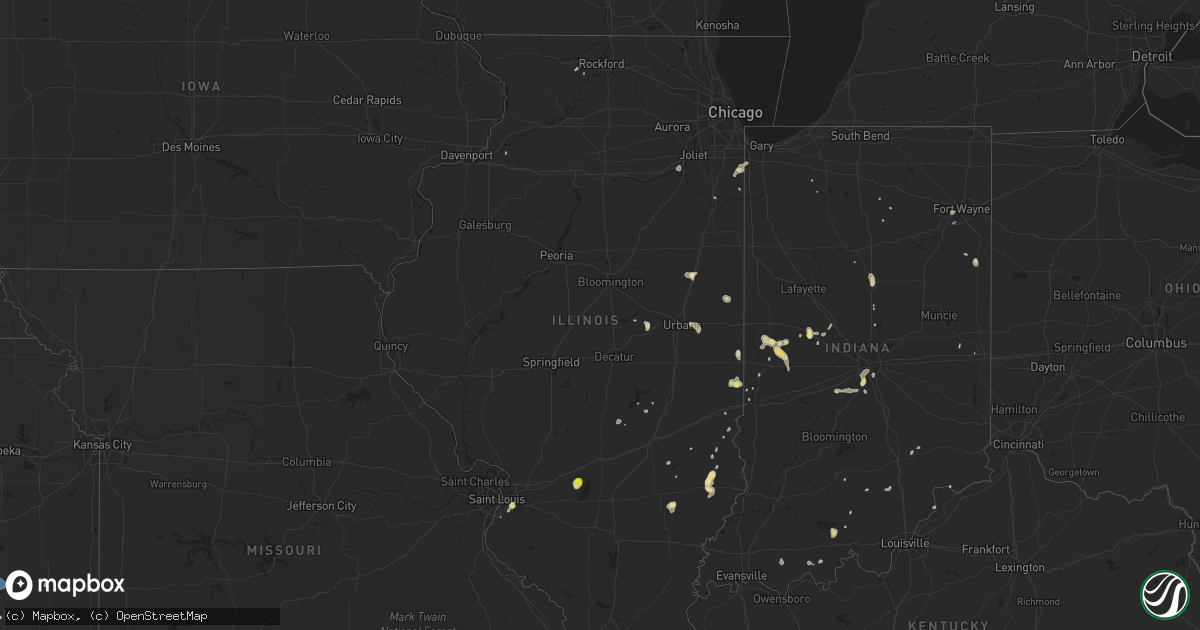
Hail Map in Illinois on July 8, 2020
Get this storm
July 8 map
$229
one time, instant access
Download today. No call, no setup
Keep the $229
Bought the map and want the full workflow? Apply the entire $229 to a subscription within 7 days. None of it is wasted.
Every map, not just this one
This buys you this map. Subscription and you get every map we run, in the markets you choose from a few cities to whole states to nationwide. Plus real-time alerts the moment a storm fires.
Contact data
Name, contact info, occupancy, even credit band for addresses in the footprint. You go from where it hit to who to call.
Become the source they trust
Unlimited branding weather history reports on demand. You already have the documented answer ready for the property owner, and you are the one who showed up with it.
Property data and RoofTrace estimates
Pull up any address you have got, its value and the exact code rules for that jurisdiction, straight from One Click Code. Then RoofTrace estimates the squares, pitch, and roof value, priced the way you price.
Storm reports in Illinois
Illinois
| Date | Description |
|---|---|
| 07/08/20206:00 PM CDT | Large tree down |
| 07/08/20205:25 PM CDT | Two large trees were blown down blocking the road and a fair bit of corn laying down in the area of cedar road and baker road. |
| 07/08/20204:53 PM CDT | Tree snapped in back yard. Around 12 inches in diameter. |
| 07/08/20204:05 PM CDT | Video received of a landspout tornado in a field behind a menards store on the northeast side of sterling. |
| 07/08/20203:10 PM CDT | Tree limbs down on highway 15 near national shrine of our lady of the snows. |
| 07/08/20202:55 PM CDT | Tree limbs down on metrolink tracks near the fairview heights station. |
| 07/08/20202:40 PM CDT | Large tree limb fell on phone and power lines at west college and keiser avenues. Time estimated from radar. |
| 07/08/20202:20 PM CDT | Large healthy limb fell on two parked vehicles in the city of freeport. |
| 07/08/20202:10 PM CDT | Tree fell on house. Report relayed by broadcast media. Time estimated by radar. |
| 07/08/20202:10 PM CDT | Powerline down. Reported relayed by broadcast media. Time estimated by radar. |
| 07/08/20201:27 AM CDT | At 627 PM CDT, a severe thunderstorm was located over Beaver Creek, moving south at 10 mph. HAZARD...60 mph wind gusts and quarter size hail. SOURCE...Radar indicated. IMPACT...Hail damage to vehicles is expected. Expect wind damage to roofs, siding, and trees. Locations impacted include... Greenville, Tamalco, Beaver Creek, Boulder, Pleasant Mound, Keyesport, Smithboro and Dudleyville.This includes Interstate 70 in Illinois near exit 45. This also includes Carlyle Lake Recreational Area. |
| 07/08/202012:52 AM CDT | At 552 PM CDT, a severe thunderstorm was located over Paris, moving northwest at 5 mph. HAZARD...60 mph wind gusts and quarter size hail. SOURCE...Radar indicated. IMPACT...Hail damage to vehicles is expected. Expect wind damage to roofs, siding, and trees. Locations impacted include... Paris, Vermilion, Edgar and Edgar County Airport. |
| 07/07/202011:40 PM CDT | At 439 PM CDT, a severe thunderstorm was located over Chauncey, or 12 miles northwest of Lawrenceville, and is nearly stationary. HAZARD...60 mph wind gusts and quarter size hail. SOURCE...Radar indicated. IMPACT...Hail damage to vehicles is expected. Expect wind damage to roofs, siding, and trees. Locations impacted include... Sumner, Claremont, Hardinville, Chauncey, Petrolia and Red Hills State Park. |
| 07/07/202011:24 PM CDT | At 424 PM CDT, a severe thunderstorm was located 7 miles south of Erie, or 17 miles east of East Moline, moving south at 10 mph. HAZARD...60 mph wind gusts. SOURCE...Radar indicated. IMPACT...Expect damage to roofs, siding, and trees. Locations impacted include... Geneseo, Erie, Atkinson, Annawan, Hooppole, Osborn, Hillsdale, Portland Corners, Spring Hill, Shady Beach and Joslin.This includes the following highways... Interstate 80 in Illinois between mile markers 13 and 32. Interstate 88 between mile markers 4 and 19. |
| 07/07/202010:27 PM CDT | At 327 PM CDT, a severe thunderstorm was located near Miles, or 17 miles west of Mount Carroll, moving south at 10 mph. HAZARD...60 mph wind gusts and quarter size hail. SOURCE...Radar indicated. IMPACT...Hail damage to vehicles is expected. Expect wind damage to roofs, siding, and trees. Locations impacted include... Preston, Miles, Charlotte, Andover, Spragueville, Green Island, Van Buren, Goose Lake, Bryant, Reeceville, Camp Miss-Elk-Ton and Teeds Grove. |
| 07/07/20209:51 PM CDT | At 249 PM CDT, a severe thunderstorm was located over Davenport, moving south at 15 mph. HAZARD...60 mph wind gusts. SOURCE...Trained weather spotters. IMPACT...Expect damage to roofs, siding, and trees. Locations impacted include... Davenport, Bettendorf, Eldridge, Long Grove, Riverdale, Donahue, Mississippi Valley Fairgrounds, Davenport Municipal Airport, Park View, Scott County Park and Rock Island Arsenal.This includes the following highways... Interstate 74 in Iowa between mile markers 1 and 5. Interstate 80 in Iowa between mile markers 289 and 300. Interstate 280 between mile markers 1 and 5. |
| 07/07/20209:48 PM CDT | At 248 PM CDT, a severe thunderstorm was located over Centreville, moving east at 5 mph. HAZARD...60 mph wind gusts. SOURCE...Radar indicated. IMPACT...Expect damage to roofs, siding, and trees. Locations impacted include... Belleville, O'Fallon, East St. Louis, Collinsville, Fairview Heights, Cahokia, Swansea, Shiloh, Centreville, Caseyville, Washington Park, Scott AFB, Cahokia Parks Airport, Alorton and Sauget.This includes Interstate 64 in Illinois between exits 9 and 19. |
| 07/07/20207:10 PM CDT | Photo shared on twitter of a large tree limb blown down. Time estimated. |
All States Impacted by Hail Map on July 8, 2020
Cities Impacted by Hail Map on July 8, 2020
- Alborn, MN
- Lake Norden, SD
- Lake Preston, SD
- Erwin, SD
- Kenton, OH
- Rushsylvania, OH
- Ridgeway, OH
- Weldon, IL
- Olla, LA
- Brookston, MN
- Saginaw, MN
- Bolton Landing, NY
- Huletts Landing, NY
- Hague, NY
- Kingman, IN
- Bloomingdale, IN
- Morristown, MN
- Puposky, MN
- Shevlin, MN
- Motley, MN
- Pillager, MN
- Ortonville, MN
- Long Pine, NE
- Arthur, NE
- Aurora, NE
- Hunter, KS
- Kadoka, SD
- Isle, MN
- Mora, MN
- Charlestown, NH
- Alstead, NH
- Acworth, NH
- South Acworth, NH
- Putney, VT
- Geneva, NE
- Ohiowa, NE
- Milligan, NE
- Exeter, NE
- Fairmont, NE
- Grant Park, IL
- Clay Center, KS
- Minneapolis, KS
- Solomon, KS
- Hope, KS
- Longford, KS
- Talmage, KS
- Miltonvale, KS
- Abilene, KS
- Enterprise, KS
- Lincoln, KS
- Kevil, KY
- Big Stone City, SD
- Clinton, MN
- Corona, SD
- Sumner, IL
- Claremont, IL
- Brainerd, MN
- Wheaton, MN
- Estelline, SD
- Clear Lake, SD
- Loda, IL
- Hampton, MN
- Vermillion, MN
- Hastings, MN
- Lance Creek, WY
- Oconto, NE
- Solon Springs, WI
- New London, MN
- Goodland, MN
- Brook Park, MN
- Hudson, WI
- River Falls, WI
- Valentine, NE
- Bassett, NE
- Ainsworth, NE
- Ogema, MN
- Canyon, MN
- Stillwater, NY
- Belgrade, NE
- Saint Edward, NE
- Fullerton, NE
- Cedar Rapids, NE
- Albion, NE
- Wolbach, NE
- Hanover, KS
- Hollenberg, KS
- Washington, KS
- Faribault, MN
- Edgemont, SD
- Farmington, ME
- Philip, SD
- Whitney, NE
- Ashton, NE
- Oberlin, KS
- Bagley, MN
- Bemidji, MN
- Solway, MN
- Leonard, MN
- North Platte, NE
- Paynesville, MN
- Spicer, MN
- Belgrade, MN
- Sebeka, MN
- Backus, MN
- Staples, MN
- Hinckley, MN
- Wilsonville, NE
- Park Rapids, MN
- Hackensack, MN
- Walker, MN
- Gordon, WI
- Sarona, WI
- Spooner, WI
- Shell Lake, WI
- Wood Lake, NE
- Johnstown, NE
- Hazard, NE
- Paris, IL
- Concordia, KS
- Stockville, NE
- Monticello, IL
- De Land, IL
- Henderson, MN
- Perham, MN
- Frazee, MN
- Henning, IL
- Rossville, IL
- Bloomer, WI
- Chippewa Falls, WI
- Hot Springs, SD
- Derby, KS
- Haysville, KS
- Mason, WI
- Carpenter, SD
- Parks, NE
- Martin, SD
- Tuthill, SD
- Cottage Grove, MN
- Culbertson, NE
- McCook, NE
- Lake Nebagamon, WI
- Brule, WI
- Jordan, MN
- Shakopee, MN
- Eustis, NE
- Elsie, NE
- Centerville, IN
- Richmond, IN
- Cody, NE
- Graytown, OH
- Elmore, OH
- Oak Harbor, OH
- Nevis, MN
- Kimball, NE
- Peetz, CO
- Padroni, CO
- Blackduck, MN
- Wilmot, SD
- Paradise, KS
- Natoma, KS
- Jonesville, LA
- Mankato, KS
- Glen Elder, KS
- Beloit, KS
- Poplar, WI
- Aitkin, MN
- Arapahoe, NE
- Elwood, NE
- Wood River, NE
- Prospect, KY
- Goshen, KY
- Menahga, MN
- Mcgregor, MN
- Tamarack, MN
- Frederic, WI
- Moorefield, NE
- Grand Rapids, MN
- Swatara, MN
- Hill City, MN
- Remer, MN
- Scenic, SD
- Jim Falls, WI
- Cadott, WI
- Thedford, NE
- Gregory, SD
- Hay Springs, NE
- Rushville, NE
- Pine Ridge, SD
- Fairburn, SD
- South Haven, MN
- Watkins, MN
- Dassel, MN
- Kimball, MN
- Cornell, WI
- Cook, MN
- Hendley, NE
- Siren, WI
- Buffalo Gap, SD
- Winfield, PA
- Freeburg, PA
- Middleburg, PA
- Selinsgrove, PA
- Salem, IN
- Crosby, MN
- Lyons, KS
- Fair Haven, VT
- Whitehall, NY
- Ponsford, MN
- Kettle River, MN
- Cromwell, MN
- Spalding, NE
- David City, NE
- Clark, SD
- Willow Lake, SD
- Raymond, SD
- Ely, MN
- Marsland, NE
- Hemingford, NE
- Shelby, NE
- Mason City, NE
- Phillips, ME
- Tiro, OH
- Crestline, OH
- Davenport, NE
- Clifton, TN
- Osage, MN
- Crawfordsville, IN
- Bena, MN
- Champion, NE
- Walpole, NH
- Marenisco, MI
- Ewen, MI
- Bergland, MI
- Bruce Crossing, MI
- Pelican Rapids, MN
- Round Lake, NY
- Mechanicville, NY
- Clifton Park, NY
- Ballston Spa, NY
- Ballston Lake, NY
- Waldo, KS
- Osborne, KS
- South Range, WI
- Maple, WI
- Beecher, IL
- Crete, IL
- Cambridge, NE
- Pequot Lakes, MN
- Nisswa, MN
- Oxford, NE
- Edison, NE
- Holbrook, NE
- Avon, MN
- Milton, VT
- Colchester, VT
- Dix, NE
- Hermosa, SD
- Jewell, KS
- Randall, KS
- Cushing, MN
- Henning, MN
- Amelia, NE
- Trenton, NE
- Dieterich, IL
- Wheeler, IL
- Newton, IL
- Wrenshall, MN
- Bartlett, NE
- Odessa, MN
- Seneca, NE
- Stone Lake, WI
- Springbrook, WI
- Springview, NE
- Baxter, MN
- Wanblee, SD
- Midland, SD
- Westmoreland, NH
- Keene, NH
- Westminster, VT
- Richmond, VT
- Jericho, VT
- Williston, VT
- New Cambria, KS
- Salina, KS
- Gentryville, IN
- Tennyson, IN
- Gaastra, MI
- Caspian, MI
- Iron River, MI
- Sturgeon Lake, MN
- Palisade, MN
- Zimmerman, MN
- Saint Francis, MN
- Lower Brule, SD
- Sherburn, MN
- Otis, KS
- Naper, NE
- Cozad, NE
- Bloomington, NE
- Scottsburg, IN
- Hillsboro, KS
- Newton, KS
- Holyoke, MN
- Center Sandwich, NH
- Holderness, NH
- Center Harbor, NH
- Moultonborough, NH
- Alda, NE
- Grand Island, NE
- New Underwood, SD
- Melrose, MN
- Minneapolis, MN
- Delphos, KS
- Tunkhannock, PA
- Doland, SD
- Clemons, NY
- Wood, SD
- Winner, SD
- Kyle, SD
- Allen, SD
- Rangeley, ME
- Burwell, NE
- Huron, SD
- Hitchcock, SD
- Belleville, IL
- East Saint Louis, IL
- Fairfax, SD
- Crawford, NE
- Detroit, MI
- Highland Park, MI
- Alton, KS
- Keyesport, IL
- Carlyle, IL
- Greenville, IL
- Cotton, MN
- Duluth, MN
- Oneill, NE
- Ericson, NE
- Olmstead, KY
- Luck, WI
- Grantsburg, WI
- Cushing, WI
- Battle Lake, MN
- Dalton, MN
- Waterville, MN
- Port Wing, WI
- Eldridge, IA
- Davenport, IA
- Frankfort, SD
- Clay City, IL
- Osseo, WI
- Fairchild, WI
- Oakdale, NE
- Elgin, NE
- Chisago City, MN
- Stacy, MN
- Lindstrom, MN
- Indianapolis, IN
- Sisseton, SD
- Mondovi, WI
- Eleva, WI
- Strang, NE
- New York Mills, MN
- Saint James, MN
- Superior, WI
- Thorp, WI
- Gordon, NE
- Pecatonica, IL
- Winnebago, IL
- Leaf River, IL
- Deerwood, MN
- Correctionville, IA
- Anthon, IA
- Chase, KS
- Bushton, KS
- Sterling, KS
- Geneseo, KS
- Little River, KS
- Lorraine, KS
- Sutton, NE
- Grafton, NE
- Waverly, MN
- Howard Lake, MN
- Surprise, NE
- Rising City, NE
- Moose Lake, MN
- Long Lake, WI
- Crystal Falls, MI
- Oconee, IL
- Republican City, NE
- Naponee, NE
- Kerrick, MN
- Minong, WI
- Pine River, MN
- Doniphan, NE
- Florence, SD
- Henry, SD
- Roberts, WI
- Clearwater, NE
- Ewing, NE
- Norway, KS
- Jamestown, KS
- Bunker Hill, KS
- Cleveland, MN
- Pfeifer, KS
- Hays, KS
- Webster, WI
- Bradley, SD
- Kokomo, IN
- Center Barnstead, NH
- Barnstead, NH
- West Forks, ME
- Summit, SD
- Thornton, NH
- Campton, NH
- Anselmo, NE
- Carlton, MN
- Barnum, MN
- Poultney, VT
- Wells, VT
- Middletown Springs, VT
- Tintah, MN
- Rosholt, SD
- Campbell, MN
- Fairmount, ND
- Drummond, WI
- Ottertail, MN
- Bingham, NE
- Ashby, NE
- Greenwood, IN
- Bargersville, IN
- Mount Juliet, TN
- Lebanon, TN
- Murfreesboro, TN
- Smyrna, TN
- Cedar Grove, TN
- Esko, MN
- Ridge Farm, IL
- Chrisman, IL
- Garrison, MN
- Alpena, SD
- Greeley, NE
- Chambers, NE
- Primrose, NE
- Kensington, KS
- North Vernon, IN
- Taswell, IN
- Floodwood, MN
- Wilber, NE
- Onamia, MN
- Hillman, MN
- Ironton, MN
- Almena, KS
- Beaver City, NE
- Bowlus, MN
- Holdingford, MN
- Benkelman, NE
- Cass Lake, MN
- Cold Spring, MN
- Saint Joseph, MN
- Saint Cloud, MN
- Silver Lake, IN
- New Ross, IN
- Phillipsburg, KS
- Agra, KS
- Webster, SD
- Russell, KS
- Rockville, IN
- Waveland, IN
- Marshall, IN
- Rochert, MN
- Detroit Lakes, MN
- Iroquois, SD
- Palmer, NE
- Wellfleet, NE
- Maywood, NE
- Waubay, SD
- Chadron, NE
- Fort Wayne, IN
- Dannebrog, NE
- Lebanon, NE
- Bartley, NE
- Danbury, NE
- Indianola, NE
- Cogan Station, PA
- Trout Run, PA
- Ideal, SD
- Wallingford, VT
- Dearborn, MI
- Crofton, KY
- Dawson Springs, KY
- Saint Charles, KY
- Wall, SD
- Manderson, SD
- Talmoon, MN
- Bigfork, MN
- Braham, MN
- Gothenburg, NE
- Monterey, LA
- Celina, OH
- Coldwater, OH
- Rumford, ME
- Curtice, OH
- Millbury, OH
- Bushnell, NE
- Wapakoneta, OH
- Lakewood, IL
- Cowden, IL
- Tower Hill, IL
- Montrose, MN
- Buffalo, MN
- Macy, IN
- Fort Recovery, OH
- Formoso, KS
- Ellsworth, KS
- Browerville, MN
- Merrifield, MN
- New Effington, SD
- Arlington, SD
- Hampton, NY
- Callaway, MN
- Appleton, MN
- Correll, MN
- Bruce, WI
- Bethlehem, IN
- New Washington, IN
- Saint Joseph, IL
- Brady, NE
- Riverton, NE
- Tescott, KS
- Beardsley, MN
- Annandale, MN
- Ravenna, NE
- Hurley, WI
- Mercer, WI
- Genoa, NE
- Wolsey, SD
- Arkansas City, KS
- Iron River, WI
- Wadena, MN
- Hayti, SD
- Alma, WI
- Belle Plaine, MN
- Fifty Lakes, MN
- Crosslake, MN
- Emily, MN
- Hammond, WI
- Baldwin, WI
- Hastings, NE
- Wilton, ME
- Shelby, OH
- Tell City, IN
- Vergas, MN
- Webber, KS
- Wright, MN
- Ontonagon, MI
- Imperial, NE
- Crestwood, KY
- Phelps, WI
- Ojibwa, WI
- Taylor, NE
- Loup City, NE
- Wildersville, TN
- Clearbrook, MN
- Isanti, MN
- Pine City, MN
- Mellen, WI
- Centuria, WI
- Milltown, WI
- Purdum, NE
- Chapman, KS
- Colwich, KS
- Mount Hope, KS
- Conover, WI
- Land O'Lakes, WI
- Highmore, SD
- Hankinson, ND
- English, IN
- Beaver Crossing, NE
- Mulvane, KS
- Udall, KS
- Douglass, KS
- Cerulean, KY
- Calhoun, KY
- Wessington Springs, SD
- Urbana, IL
- Clarissa, MN
- Cambridge, MN
- West Union, IL
- Saint Paul, MN
- Princeton, KY
- Oelrichs, SD
- Strum, WI
- Interior, SD
- Wilson, KS
- Fort Thompson, SD
- Phillips, NE
- Louisville, KY
- Benedict, KS
- Darlington, IN
- Morris, IL
- Channahon, IL
- Minooka, IL
- Swanton, NE
- De Witt, NE
- York, PA
- Center City, MN
- Maxwell, NE
- Hillsboro, IN
- Alamo, IN
- Waynetown, IN
- Berne, IN
- Geneva, IN
- Jacobson, MN
- Cloquet, MN
- Foxboro, WI
- Brooten, MN
- Sauk Centre, MN
- Stamford, NE
- Bedford, IN
- Longville, MN
- Abbyville, KS
- Newman Grove, NE
- Sandstone, MN
- Saint Croix Falls, WI
- North Branch, MN
- Nashwauk, MN
- Trego, WI
- Star Prairie, WI
- Deer Park, WI
- Amery, WI
- New Richmond, WI
- Dunning, NE
- Nickerson, KS
- Outing, MN
- Townshend, VT
- Chester, VT
- Millstadt, IL
- Byron, IL
- Sedgwick, KS
- Burrton, KS
- Minocqua, WI
- Sutherland, NE
- Lewisburg, PA
- Madison, MN
- Bellingham, MN
- Tampa, KS
- Noble, IL
- Cokato, MN
- Frenchboro, ME
- Brule, NE
- Cisne, IL
- West York, IL
- Watersmeet, MI
- Strong City, KS
- Cottonwood Falls, KS
- Elmdale, KS
- Yale, SD
- Mount Pleasant Mills, PA
- Stanchfield, MN
- Grandy, MN
- Prescott, WI
- Willard, WI
- Humbird, WI
- Guide Rock, NE
- Windsor, IL
- Mehoopany, PA
- Sugar Run, PA
- Hardinsburg, IN
- Paoli, IN
- Durham, KS
- Pelkie, MI
- Sergeant Bluff, IA
- Sioux City, IA
- Glasco, KS
- Vining, MN
- Parkers Prairie, MN
- Oblong, IL
- Maize, KS
- Wichita, KS
- Lewisville, MN
- Giltner, NE
- Carleton, NE
- Bluffton, MN
- Deer Creek, MN
- Finlayson, MN
- Pierz, MN
- Akeley, MN
- Verndale, MN
- Wahkon, MN
- McGrath, MN
- Naytahwaush, MN
- Mahnomen, MN
- Waubun, MN
- Robinson, IL
- Palisade, NE
- Grand View, WI
- Williamsport, PA
- Montoursville, PA
- Smith Center, KS
- Athol, KS
- Plainville, KS
- Dunnville, KY
- Phillips, WI
- Gaylord, KS
- Augusta, WI
- Woodbine, KS
- Herington, KS
- Mentone, IN
- Gibbon, NE
- Aurora, KS
- White Plains, KY
- Spencerville, OH
- Homer, IL
- Sidney, IL
- Swanzey, NH
- Waterville, KS
- Orchard, NE
- Winnetoon, NE
- Fergus Falls, MN
- Underwood, MN
- Albany, MN
- Thorntown, IN
- Dumont, MN
- Hershey, NE
- Ashland, WI
- Earlville, NY
- Hamilton, NY
- Osceola, NE
- Deweese, NE
- Fairfield, NE
- Fall Creek, WI
- Independence, WI
- Washta, IA
- Pierson, IA
- Vienna, SD
- Halsey, NE
- Evanston, IN
- Saint Meinrad, IN
- Bedford, KY
- Milton, KY
- Jamestown, IN
- Marengo, IN
- Le Center, MN
- Oral, SD
- Ord, NE
- Bellwood, NE
- Friend, NE
- Northome, MN
- Downs, KS
- Cawker City, KS
- Esbon, KS
- Lanse, MI
- Eagle Bend, MN
- Columbia, IL
- Browns Valley, MN
- Freeport, MN
- Sargent, NE
- North Judson, IN
- Carver, MN
- Sheboygan, WI
- Curtis, NE
- Alma, NE
- Orleans, NE
- Lehigh, KS
- Geddes, SD
- Rockville, NE
- Tipton, IN
- Plevna, KS
- Truman, MN
- Harris, MN
- Rush City, MN
- Bourbonnais, IL
- Hayes Center, NE
- Brooklyn, IN
- Martinsville, IN
- Monrovia, IN
- Mooresville, IN
- Rinard, IL
- Fairmont, MN
- Geneseo, IL
- Hewitt, MN
- Swanton, VT
- Wessington, SD
- Mcpherson, KS
- Inman, KS
- Mills, NE
- Armstrong Creek, WI
- Goodman, WI
- Royalton, MN
- Butte, NE
- Bonesteel, SD
- Lebanon, KS
- Canton, KS
- Cairo, NE
- Colfax, WI
- West Terre Haute, IN
- Tower, MN
- Silver Creek, NE
- Bryant, SD
- Jay, ME
- Dixfield, ME
- Eden Prairie, MN
- Swan River, MN
- Warba, MN
- High Bridge, WI
- Bluffton, IN
- Wyoming, MN
- Herrick, SD
- Castlewood, SD
- Luckey, OH
- Woodville, OH
- Oglala, SD
- Deer River, MN
- Arcadia, NE
- Calhoun, IL
- Moundridge, KS
- Sylvan Grove, KS
- Gilmanton, NH
- Belmont, NH
- Fairbury, NE
- Cicero, IN
- Noblesville, IN
- Effie, MN
- Orr, MN
- Kelliher, MN
- Homer, NE
- Mullen, NE
- Walton, IN
- Whitman, NE
- Boyceville, WI
- Boelus, NE
- Oak, NE
- Lake George, MN
- Laporte, MN
- Verdigre, NE
- Elkton, KY
- Guthrie, KY
- Allensville, KY
- Madison, IN
- Moran, KS
- Beech Grove, IN
- Dresser, WI
- Osceola, WI
- Buckley, IL
- Melvin, IL
- Paxton, IL
- Bennington, KS
- Makinen, MN
- North Loup, NE
- Diller, NE
- Pulaski, TN
- Waterbury, VT
- La Crosse, IN
- Strasburg, IL
- Gilmanton Iron Works, NH
- Alliance, NE
- Knapp, WI
- Strafford, NH
- Otego, NY
- Hayward, WI
- Lopez, PA
- Mildred, PA
- Dushore, PA
- Montezuma, IN
- Clear Lake, WI
- Clayton, WI
- Hagerstown, IN
- Holyrood, KS
- Peever, SD
- Bertha, MN
- Balsam Lake, WI
- Long Grove, IA
- Donahue, IA
- Essex Junction, VT
- Claremont, NH
- Wounded Knee, SD
- Marshall, IL
- Dorchester, NE
- Western, NE
- New Vineyard, ME
- Strong, ME
- Woodston, KS
- Rocky Ridge, OH
- Redlake, MN
- Redby, MN
- Salem, MO
- Virginia, MN
- Nortonville, KY
- Marlborough, NH
- Troy, NH
- Jaffrey, NH
- Litchfield, NE
- Windsor, KY
- Rice Lake, WI
- Cameron, WI
- Saratoga Springs, NY
- Shelton, NE
- Foxhome, MN
- Breckenridge, MN
- Bertrand, NE
- Trout Creek, MI
- Silver Bay, NY
- Plymouth, NE
- Winter, WI
- Hines, MN
- Bethlehem, NH
- Aldrich, MN
- Princeton, MN
- Shickley, NE
- Julesburg, CO
- Venango, NE
- Trumbull, NE
- Glenvil, NE
- Lawrence, NE
- Le Sueur, MN
- Inman, NE
- Savannah, TN
- Courtland, KS
- Atkinson, NE
- Brewster, NE
- Dyer, IN
- Saint John, IN
- Aurora, MN
- Miller, SD
- Claire City, SD
- Kearney, NE
- Marengo, WI
- Gurley, NE
- Sidney, NE
- Big Springs, NE
- Ovid, CO
- Sedgwick, CO
- Chappell, NE
- Lodgepole, NE
- Crook, CO
- Madrid, NE
- Amherst, CO
- Grant, NE
- Hyannis, NE
- Newport, NE
- Stuart, NE
- Axtell, NE
- Loomis, NE
- Franklin, NE
- Smithfield, NE
- Wilcox, NE
- Holdrege, NE
- Minden, NE
- Norton, KS
- Farnam, NE
- Inavale, NE
- Prairie View, KS
- Long Island, KS
- Dickens, NE
- Campbell, NE
- Upland, NE
- Atlanta, NE
- Funk, NE
- Hildreth, NE
- Clay Center, NE
- Wakefield, KS
- Hamilton, KS
- Gresham, NE
- Neosho Rapids, KS
- Burr, NE
- Barneston, NE
- Sprague, NE
- Auburn, NE
- Riley, KS
- Saint George, KS
- Allen, KS
- Cordova, NE
- Hampton, NE
- Goehner, NE
- Lincoln, NE
- Clarks, NE
- Pawnee City, NE
- Tobias, NE
- Marquette, NE
- Scotia, NE
- Table Rock, NE
- Liberty, NE
- Saronville, NE
- Axtell, KS
- Matfield Green, KS
- Raymond, NE
- Saint Marys, KS
- Topeka, KS
- Harvard, NE
- Holstein, NE
- Burr Oak, KS
- Unadilla, NE
- Juniata, NE
- Murdock, NE
- Red Cloud, NE
- Manhattan, KS
- Frankfort, KS
- Sterling, NE
- Leonardville, KS
- Ruskin, NE
- Home, KS
- Marysville, KS
- Clyde, KS
- Crete, NE
- Bremen, KS
- Burlingame, KS
- Filley, NE
- Ong, NE
- Olsburg, KS
- Bern, KS
- Central City, NE
- Elba, NE
- Kenesaw, NE
- Greenleaf, KS
- Council Grove, KS
- Hubbell, NE
- Munden, KS
- Blue Springs, NE
- Steele City, NE
- Malcolm, NE
- Bladen, NE
- Riverdale, NE
- Eskridge, KS
- Crab Orchard, NE
- Haddam, KS
- Cuba, KS
- Saint Paul, NE
- Bruning, NE
- Ogden, KS
- Polk, NE
- Jansen, NE
- Reynolds, NE
- Bennet, NE
- Steinauer, NE
- McFarland, KS
- Belvue, KS
- Randolph, KS
- Linn, KS
- Osage City, KS
- Archer, NE
- Morganville, KS
- Wymore, NE
- Pleasant Dale, NE
- Pleasanton, NE
- Hickman, NE
- Roca, NE
- Belvidere, NE
- Adams, NE
- Deshler, NE
- Benedict, NE
- Paxico, KS
- Edgar, NE
- Harveyville, KS
- Utica, NE
- Chester, NE
- Alexandria, NE
- Saint Libory, NE
- Comstock, NE
- Endicott, NE
- Johnson, NE
- Greenwood, NE
- Narka, KS
- Baileyville, KS
- Virgil, KS
- Morrowville, KS
- Milford, KS
- Oketo, KS
- Emporia, KS
- Avoca, NE
- Madison, KS
- Heartwell, NE
- York, NE
- Vermillion, KS
- Belleville, KS
- Clatonia, NE
- Byron, NE
- Milford, NE
- Walton, NE
- Centralia, KS
- Cortland, NE
- Nelson, NE
- Otoe, NE
- Mahaska, KS
- Seward, NE
- Lewiston, NE
- Garland, NE
- Daykin, NE
- Palmer, KS
- Pickrell, NE
- Beattie, KS
- Alma, KS
- Seneca, KS
- Eureka, KS
- Green, KS
- Odell, NE
- Tecumseh, NE
- Beatrice, NE
- Martell, NE
- Emmett, KS
- Superior, NE
- Virginia, NE
- Firth, NE
- Dunbar, NE
- Elk Creek, NE
- Junction City, KS
- Talmage, NE
- Agenda, KS
- Fort Riley, KS
- Westmoreland, KS
- Syracuse, NE
- Du Bois, NE
- Lorton, NE
- Admire, KS
- Brock, NE
- Panama, NE
- Chapman, NE
- Elmwood, NE
- Cook, NE
- Inland, NE
- Summerfield, KS
- Douglas, NE
- Corning, KS
- Onaga, KS
- Waco, NE
- Alvo, NE
- Clifton, KS
- Hartford, KS
- Gilead, NE
- McCool Junction, NE
- Blue Hill, NE
- Hardy, NE
- Olpe, KS
- Republic, KS
- Roseland, NE
- Staplehurst, NE
- Yates Center, KS
- Scandia, KS
- Ansley, NE
- Westerville, NE
- Burchard, NE
- Nebraska City, NE
- Reading, KS
- Hallam, NE
- Weeping Water, NE
- Havensville, KS
- Stromsburg, NE
- Broken Bow, NE
- Wamego, KS
- Americus, KS
- Maple Hill, KS
- Hebron, NE
- Hordville, NE
- Bradshaw, NE
- Alta Vista, KS
- Auburn, KS
- Humboldt, NE
- Barnes, KS
- Denton, NE
- Ayr, NE
- Waverly, NE
- Blue Rapids, KS
- Gridley, KS
- Henderson, NE
- Farwell, NE
- Davey, NE
- Eagle, NE
- Palmyra, NE
- Eddyville, NE
- Sumner, NE
- Miller, NE
- Lexington, NE
- Amherst, NE
- Callaway, NE
- Elsmere, NE
- Spofford, NH
- Pittsfield, NH
- Lincoln, NH
- Meredith, NH
- Yoder, IN
- Saint Albans, VT
- Fairfield, VT
- Danby, VT
- Pawlet, VT
- East Dorset, VT
- Oxford, ME
- Mount Vernon, ME
- Belgrade, ME
- Kents Hill, ME
- Ashby, MN
- Wahpeton, ND
- Prior Lake, MN
- New Prague, MN
- Oquossoc, ME
- Mexico, ME
- Andover, ME
- Roxbury, ME
- Hanover, ME
- Bethel, ME
- Buckfield, ME
- Sumner, ME
- West Paris, ME
- Peru, ME
- Bryant Pond, ME
- Tenants Harbor, ME
- Bremen, ME
- Round Pond, ME
- Damariscotta, ME
- Cushing, ME
- Waldoboro, ME
- Friendship, ME
- Bristol, ME
- Spruce Head, ME
- Whitefield, NH
- Littleton, NH
- Winchester, NH
- Upson, WI
- Butternut, WI
- Washburn, WI
- Saxon, WI
- Glidden, WI
- Danbury, WI
- Cable, WI
- Iron Belt, WI
- Clam Lake, WI


