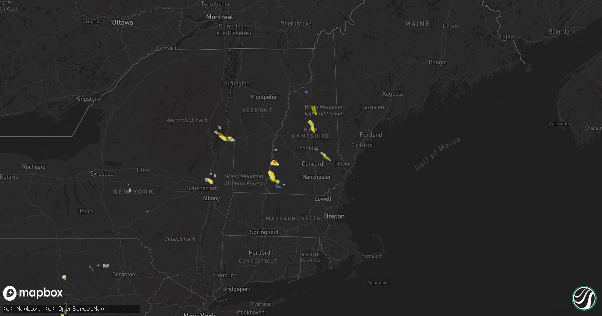
Hail Map in New Hampshire on July 8, 2020
Get this storm
July 8 map
$229
one time, instant access
Download today. No call, no setup
Keep the $229
Bought the map and want the full workflow? Apply the entire $229 to a subscription within 7 days. None of it is wasted.
Every map, not just this one
This buys you this map. Subscription and you get every map we run, in the markets you choose from a few cities to whole states to nationwide. Plus real-time alerts the moment a storm fires.
Contact data
Name, contact info, occupancy, even credit band for addresses in the footprint. You go from where it hit to who to call.
Become the source they trust
Unlimited branding weather history reports on demand. You already have the documented answer ready for the property owner, and you are the one who showed up with it.
Property data and RoofTrace estimates
Pull up any address you have got, its value and the exact code rules for that jurisdiction, straight from One Click Code. Then RoofTrace estimates the squares, pitch, and roof value, priced the way you price.
Storm reports in New Hampshire
New Hampshire
| Date | Description |
|---|---|
| 07/08/20206:30 PM CDT | Trees down on nh-113 and willoughby rd. Time estimated from radar. |
| 07/08/20206:30 PM CDT | Police report trees and wires down. Time estimated from radar. |
| 07/08/20204:45 PM CDT | Trees and wires down transvale rd. Time estimated from radar. |
| 07/08/20204:45 PM CDT | Trees and wires down on north street. Time estimated from radar. |
| 07/08/20204:30 PM CDT | Trees down in town. Reported by sheriffs office. Time estimated from radar. |
| 07/08/20204:30 PM CDT | Tons of trees down reported in town by police. Time estimated from radar. |
| 07/08/20204:25 PM CDT | Corrects previous tstm wnd dmg report from 2 sw temple. Trees and wires down on moran rd. Time estimated from radar. |
| 07/08/20204:25 PM CDT | Trees and wires down on hadley highway. Time estimated from radar. |
| 07/08/20204:25 PM CDT | Trees and wires down on kelley rd. Time estimated from radar. |
| 07/08/20204:15 PM CDT | Tree limbs down on mccoy rd. |
| 07/08/20203:45 PM CDT | Trees and wires down on marlboro st. Time estimated from radar. |
| 07/08/20203:45 PM CDT | Corrects time from previous tstm wnd dmg report from 2 e stark. Trees and wires down on kelley rd. Time estimated from radar. |
| 07/08/20203:35 PM CDT | Trees downed on summit road. |
| 07/08/20203:35 PM CDT | Trees and wires down in town. Reported by sheriffs office. Time estimated from radar. |
| 07/08/20203:32 PM CDT | Hail for 8 mins. |
| 07/08/20202:45 PM CDT | Hail up to 1.75... Hail lasted for 10 minutes. Minor damage to car hood. |
| 07/08/20202:45 PM CDT | Trees and wires down in town on route 63. Time estimated from radar. |
| 07/08/20202:30 PM CDT | Trees and wires down on mercier rd. Time estimated from radar. |
| 07/08/20201:50 PM CDT | Between acworth and south acworth on hill road off of rte 123a. |
| 07/08/20201:40 PM CDT | Storm also damaged home anemometer. |
| 07/08/20201:25 PM CDT | Measured on rt 123a... 1 hail with some 1.25 stones mixed in. |
| 07/08/20202:11 AM CDT | At 711 PM EDT, severe thunderstorms were located along a line extending from near Scarborough to 11 miles west of Waterboro, moving east at 20 mph. HAZARD...60 mph wind gusts and quarter size hail. SOURCE...Radar indicated. IMPACT...Hail damage to vehicles is expected. Expect wind damage to roofs, siding, and trees. Locations impacted include... Portland, South Portland, Biddeford, Westbrook, Alfred, Sanford, Saco, Gorham, Falmouth, Kennebunk, Cape Elizabeth, Buxton, Lebanon, Hollis, Kennebunkport, Scarborough, Old Orchard Beach, Waterboro, Lyman and Arundel.This includes the following highways... Interstate 295 between mile markers 1 and 8. Interstate 95 between mile markers 26 and 50.This also includes... Fortunes Rock Beach, Higgins Beach, Crescent Beach State Park, andScarborough Beach State Park. Peaks Island, Long Island, Cushing Island, Great Diamond Island,and Mackworth Island. |
| 07/08/20201:35 AM CDT | At 635 PM EDT, severe thunderstorms were located along a line extending from near Conway to near Woodstock, moving south at 15 mph. HAZARD...60 mph wind gusts and quarter size hail. SOURCE...Radar indicated. IMPACT...Hail damage to vehicles is expected. Expect wind damage to roofs, siding, and trees. Locations impacted include... Conway, Moultonborough, Plymouth, Ossipee, Meredith, Holderness, Ashland, Effingham, Woodstock, Tamworth, Sandwich, Wolfeboro, Madison, Freedom, Center Harber, Bridgewater, Albany, Eaton, Ellsworth and Tuftonboro.This includes Interstate 93 between mile markers 76 and 96. This also includes... Squam Lake, Mount Chocorua, Mount Whiteface, Elbow Pond RecreationArea, and Mount Tecumseh. |
| 07/08/202012:58 AM CDT | At 557 PM EDT, a severe thunderstorm was located 10 miles east of Lincoln, moving southeast at 25 mph. HAZARD...60 mph wind gusts and quarter size hail. SOURCE...Radar indicated. IMPACT...Hail damage to vehicles is expected. Expect wind damage to roofs, siding, and trees. Locations impacted include... Conway, Lincoln, Ossipee, Franconia, Tamworth, Woodstock, Sandwich, Bartlett, Madison, Albany, Livermore, Hart's Location, Waterville Valley and Thornton.This includes Interstate 93 between mile markers 101 and 102. This also includes... Franconia Ridge, Mount Chocorua, Mount Lafayette, Mount Garfield,and Mount Whiteface. |
| 07/08/202012:57 AM CDT | At 557 PM EDT, a severe thunderstorm was located over Riverton, moving southeast at 35 mph. HAZARD...60 mph wind gusts and quarter size hail. SOURCE...Law enforcement. IMPACT...Minor hail damage to vehicles is possible. Expect wind damage to trees and powerlines. Locations impacted include... Barre, Montpelier, Calais, Braintree Hill, Bradford, Orange, Thetford Hill State Park, Waterbury Village, Websterville, Lincoln, Thetford, Worcester, Middlesex, Granville, Marshfield, Fairlee, Tunbridge, Hancock, Sharon and Corinth Corners. |
| 07/08/202012:41 AM CDT | At 541 PM EDT, a severe thunderstorm was located 7 miles north of Conway, moving east at 10 mph. HAZARD...60 mph wind gusts and quarter size hail. SOURCE...Radar indicated. IMPACT...Hail damage to vehicles is expected. Expect wind damage to roofs, siding, and trees. Locations impacted include... Conway, Fryeburg, Bartlett, Brownfield, Denmark, Lovell, Jackson, Chatham, Stowe and Sweden.This also includes... Kearsarge North and Peary Mountain. |
| 07/08/202012:09 AM CDT | At 508 PM EDT, a cluster of severe thunderstorm was located over southeast Cheshire County, moving east at 25 mph. HAZARD...60 mph wind gusts and quarter size hail. SOURCE...Radar indicated. IMPACT...Hail damage to vehicles is expected. Expect wind damage to roofs, siding, and trees. Locations impacted include... Jaffrey, Milford, Amherst, Peterborough, Marlborough, Mont Vernon, Greenfield, Lyndeborough, Dublin, Richmond, Harrisville, Rindge, New Ipswich, Sharon, Greenville, Wilton, Fitzwilliam, Troy, Brookline and Mason.This also includes... Mount Monadnock and North Pack Monadnock. |
| 07/08/202012:06 AM CDT | At 505 PM EDT, a cluster of severe thunderstorms was located in southern Oxford County, moving east at 20 mph. HAZARD...60 mph wind gusts and quarter size hail. SOURCE...Radar indicated. IMPACT...Hail damage to vehicles is expected. Expect wind damage to roofs, siding, and trees. Locations impacted include... Bridgton, Fryeburg, Naples, Waterford, Casco, Harrison, Buckfield, Hebron, Denmark, Lovell, Greenwood, Otisfield, Sweden, Stowe, Stoneham, Norway, Oxford, Paris, Albany and West Paris.This also includes... Long Lake, Deer Hills, Crocker Hill, Streaked Mountain, andSingepole Ridge. |
| 07/07/202011:40 PM CDT | At 440 PM EDT, a severe thunderstorm was located over Harrisville, or 7 miles north of Jaffrey, moving east at 15 mph. HAZARD...60 mph wind gusts and quarter size hail. SOURCE...Radar indicated. IMPACT...Hail damage to vehicles is expected. Expect wind damage to roofs, siding, and trees. Locations impacted include... Jaffrey, Peterborough, Antrim, Marlborough, Greenfield, Lyndeborough, Dublin, Francestown, Bennington, Harrisville, Nelson, Hancock, Sharon, Temple, Roxbury, New Ipswich and Wilton.This also includes... North Pack Monadnock. |
| 07/07/202011:34 PM CDT | At 434 PM EDT, a severe thunderstorm was located near Effingham, or 9 miles north of Ossipee, moving east at 25 mph. HAZARD...60 mph wind gusts and quarter size hail. SOURCE...Radar indicated. IMPACT...Hail damage to vehicles is expected. Expect wind damage to roofs, siding, and trees. Locations impacted include... Conway, Ossipee, Hiram, Effingham, Cornish, Tamworth, Limerick, Madison, Brownfield, Freedom, Denmark, Eaton, Parsonsfield and Porter.This also includes... Burnt Meadow Mountains, Peary Mountain, and Mount Cutler. |
| 07/07/202011:25 PM CDT | At 425 PM EDT, a severe thunderstorm was located over Westmoreland, or on the west side of Keene, moving southeast at 10 mph. HAZARD...60 mph wind gusts and quarter size hail. SOURCE...Radar indicated. IMPACT...Hail damage to vehicles is expected. Expect wind damage to roofs, siding, and trees. Locations impacted include... Keene, Winchester, Dublin, Richmond, Harrisville, Nelson, Marlborough, Roxbury, Troy, Sullivan, Westmoreland, Swanzey, Chesterfield, Surry, Gilsum and Walpole. |
| 07/07/20209:19 PM CDT | At 218 PM EDT, a severe thunderstorm was located near Charlestown, or 12 miles south of Claremont, moving east at 15 mph. HAZARD...60 mph wind gusts and quarter size hail. SOURCE...Radar indicated. IMPACT...Hail damage to vehicles is expected. Expect wind damage to roofs, siding, and trees. Locations impacted include... Charlestown, Antrim, Bradford, Nelson, Gilsum, Marlow, Walpole, Sullivan, Alstead, Surry, Windsor, Newport, Westmoreland, Lempster, Acworth, Goshen, Langdon, Washington, Unity and Newbury. |
All States Impacted by Hail Map on July 8, 2020
Cities Impacted by Hail Map on July 8, 2020
- Alborn, MN
- Lake Norden, SD
- Lake Preston, SD
- Erwin, SD
- Kenton, OH
- Rushsylvania, OH
- Ridgeway, OH
- Weldon, IL
- Olla, LA
- Brookston, MN
- Saginaw, MN
- Bolton Landing, NY
- Huletts Landing, NY
- Hague, NY
- Kingman, IN
- Bloomingdale, IN
- Morristown, MN
- Puposky, MN
- Shevlin, MN
- Motley, MN
- Pillager, MN
- Ortonville, MN
- Long Pine, NE
- Arthur, NE
- Aurora, NE
- Hunter, KS
- Kadoka, SD
- Isle, MN
- Mora, MN
- Charlestown, NH
- Alstead, NH
- Acworth, NH
- South Acworth, NH
- Putney, VT
- Geneva, NE
- Ohiowa, NE
- Milligan, NE
- Exeter, NE
- Fairmont, NE
- Grant Park, IL
- Clay Center, KS
- Minneapolis, KS
- Solomon, KS
- Hope, KS
- Longford, KS
- Talmage, KS
- Miltonvale, KS
- Abilene, KS
- Enterprise, KS
- Lincoln, KS
- Kevil, KY
- Big Stone City, SD
- Clinton, MN
- Corona, SD
- Sumner, IL
- Claremont, IL
- Brainerd, MN
- Wheaton, MN
- Estelline, SD
- Clear Lake, SD
- Loda, IL
- Hampton, MN
- Vermillion, MN
- Hastings, MN
- Lance Creek, WY
- Oconto, NE
- Solon Springs, WI
- New London, MN
- Goodland, MN
- Brook Park, MN
- Hudson, WI
- River Falls, WI
- Valentine, NE
- Bassett, NE
- Ainsworth, NE
- Ogema, MN
- Canyon, MN
- Stillwater, NY
- Belgrade, NE
- Saint Edward, NE
- Fullerton, NE
- Cedar Rapids, NE
- Albion, NE
- Wolbach, NE
- Hanover, KS
- Hollenberg, KS
- Washington, KS
- Faribault, MN
- Edgemont, SD
- Farmington, ME
- Philip, SD
- Whitney, NE
- Ashton, NE
- Oberlin, KS
- Bagley, MN
- Bemidji, MN
- Solway, MN
- Leonard, MN
- North Platte, NE
- Paynesville, MN
- Spicer, MN
- Belgrade, MN
- Sebeka, MN
- Backus, MN
- Staples, MN
- Hinckley, MN
- Wilsonville, NE
- Park Rapids, MN
- Hackensack, MN
- Walker, MN
- Gordon, WI
- Sarona, WI
- Spooner, WI
- Shell Lake, WI
- Wood Lake, NE
- Johnstown, NE
- Hazard, NE
- Paris, IL
- Concordia, KS
- Stockville, NE
- Monticello, IL
- De Land, IL
- Henderson, MN
- Perham, MN
- Frazee, MN
- Henning, IL
- Rossville, IL
- Bloomer, WI
- Chippewa Falls, WI
- Hot Springs, SD
- Derby, KS
- Haysville, KS
- Mason, WI
- Carpenter, SD
- Parks, NE
- Martin, SD
- Tuthill, SD
- Cottage Grove, MN
- Culbertson, NE
- McCook, NE
- Lake Nebagamon, WI
- Brule, WI
- Jordan, MN
- Shakopee, MN
- Eustis, NE
- Elsie, NE
- Centerville, IN
- Richmond, IN
- Cody, NE
- Graytown, OH
- Elmore, OH
- Oak Harbor, OH
- Nevis, MN
- Kimball, NE
- Peetz, CO
- Padroni, CO
- Blackduck, MN
- Wilmot, SD
- Paradise, KS
- Natoma, KS
- Jonesville, LA
- Mankato, KS
- Glen Elder, KS
- Beloit, KS
- Poplar, WI
- Aitkin, MN
- Arapahoe, NE
- Elwood, NE
- Wood River, NE
- Prospect, KY
- Goshen, KY
- Menahga, MN
- Mcgregor, MN
- Tamarack, MN
- Frederic, WI
- Moorefield, NE
- Grand Rapids, MN
- Swatara, MN
- Hill City, MN
- Remer, MN
- Scenic, SD
- Jim Falls, WI
- Cadott, WI
- Thedford, NE
- Gregory, SD
- Hay Springs, NE
- Rushville, NE
- Pine Ridge, SD
- Fairburn, SD
- South Haven, MN
- Watkins, MN
- Dassel, MN
- Kimball, MN
- Cornell, WI
- Cook, MN
- Hendley, NE
- Siren, WI
- Buffalo Gap, SD
- Winfield, PA
- Freeburg, PA
- Middleburg, PA
- Selinsgrove, PA
- Salem, IN
- Crosby, MN
- Lyons, KS
- Fair Haven, VT
- Whitehall, NY
- Ponsford, MN
- Kettle River, MN
- Cromwell, MN
- Spalding, NE
- David City, NE
- Clark, SD
- Willow Lake, SD
- Raymond, SD
- Ely, MN
- Marsland, NE
- Hemingford, NE
- Shelby, NE
- Mason City, NE
- Phillips, ME
- Tiro, OH
- Crestline, OH
- Davenport, NE
- Clifton, TN
- Osage, MN
- Crawfordsville, IN
- Bena, MN
- Champion, NE
- Walpole, NH
- Marenisco, MI
- Ewen, MI
- Bergland, MI
- Bruce Crossing, MI
- Pelican Rapids, MN
- Round Lake, NY
- Mechanicville, NY
- Clifton Park, NY
- Ballston Spa, NY
- Ballston Lake, NY
- Waldo, KS
- Osborne, KS
- South Range, WI
- Maple, WI
- Beecher, IL
- Crete, IL
- Cambridge, NE
- Pequot Lakes, MN
- Nisswa, MN
- Oxford, NE
- Edison, NE
- Holbrook, NE
- Avon, MN
- Milton, VT
- Colchester, VT
- Dix, NE
- Hermosa, SD
- Jewell, KS
- Randall, KS
- Cushing, MN
- Henning, MN
- Amelia, NE
- Trenton, NE
- Dieterich, IL
- Wheeler, IL
- Newton, IL
- Wrenshall, MN
- Bartlett, NE
- Odessa, MN
- Seneca, NE
- Stone Lake, WI
- Springbrook, WI
- Springview, NE
- Baxter, MN
- Wanblee, SD
- Midland, SD
- Westmoreland, NH
- Keene, NH
- Westminster, VT
- Richmond, VT
- Jericho, VT
- Williston, VT
- New Cambria, KS
- Salina, KS
- Gentryville, IN
- Tennyson, IN
- Gaastra, MI
- Caspian, MI
- Iron River, MI
- Sturgeon Lake, MN
- Palisade, MN
- Zimmerman, MN
- Saint Francis, MN
- Lower Brule, SD
- Sherburn, MN
- Otis, KS
- Naper, NE
- Cozad, NE
- Bloomington, NE
- Scottsburg, IN
- Hillsboro, KS
- Newton, KS
- Holyoke, MN
- Center Sandwich, NH
- Holderness, NH
- Center Harbor, NH
- Moultonborough, NH
- Alda, NE
- Grand Island, NE
- New Underwood, SD
- Melrose, MN
- Minneapolis, MN
- Delphos, KS
- Tunkhannock, PA
- Doland, SD
- Clemons, NY
- Wood, SD
- Winner, SD
- Kyle, SD
- Allen, SD
- Rangeley, ME
- Burwell, NE
- Huron, SD
- Hitchcock, SD
- Belleville, IL
- East Saint Louis, IL
- Fairfax, SD
- Crawford, NE
- Detroit, MI
- Highland Park, MI
- Alton, KS
- Keyesport, IL
- Carlyle, IL
- Greenville, IL
- Cotton, MN
- Duluth, MN
- Oneill, NE
- Ericson, NE
- Olmstead, KY
- Luck, WI
- Grantsburg, WI
- Cushing, WI
- Battle Lake, MN
- Dalton, MN
- Waterville, MN
- Port Wing, WI
- Eldridge, IA
- Davenport, IA
- Frankfort, SD
- Clay City, IL
- Osseo, WI
- Fairchild, WI
- Oakdale, NE
- Elgin, NE
- Chisago City, MN
- Stacy, MN
- Lindstrom, MN
- Indianapolis, IN
- Sisseton, SD
- Mondovi, WI
- Eleva, WI
- Strang, NE
- New York Mills, MN
- Saint James, MN
- Superior, WI
- Thorp, WI
- Gordon, NE
- Pecatonica, IL
- Winnebago, IL
- Leaf River, IL
- Deerwood, MN
- Correctionville, IA
- Anthon, IA
- Chase, KS
- Bushton, KS
- Sterling, KS
- Geneseo, KS
- Little River, KS
- Lorraine, KS
- Sutton, NE
- Grafton, NE
- Waverly, MN
- Howard Lake, MN
- Surprise, NE
- Rising City, NE
- Moose Lake, MN
- Long Lake, WI
- Crystal Falls, MI
- Oconee, IL
- Republican City, NE
- Naponee, NE
- Kerrick, MN
- Minong, WI
- Pine River, MN
- Doniphan, NE
- Florence, SD
- Henry, SD
- Roberts, WI
- Clearwater, NE
- Ewing, NE
- Norway, KS
- Jamestown, KS
- Bunker Hill, KS
- Cleveland, MN
- Pfeifer, KS
- Hays, KS
- Webster, WI
- Bradley, SD
- Kokomo, IN
- Center Barnstead, NH
- Barnstead, NH
- West Forks, ME
- Summit, SD
- Thornton, NH
- Campton, NH
- Anselmo, NE
- Carlton, MN
- Barnum, MN
- Poultney, VT
- Wells, VT
- Middletown Springs, VT
- Tintah, MN
- Rosholt, SD
- Campbell, MN
- Fairmount, ND
- Drummond, WI
- Ottertail, MN
- Bingham, NE
- Ashby, NE
- Greenwood, IN
- Bargersville, IN
- Mount Juliet, TN
- Lebanon, TN
- Murfreesboro, TN
- Smyrna, TN
- Cedar Grove, TN
- Esko, MN
- Ridge Farm, IL
- Chrisman, IL
- Garrison, MN
- Alpena, SD
- Greeley, NE
- Chambers, NE
- Primrose, NE
- Kensington, KS
- North Vernon, IN
- Taswell, IN
- Floodwood, MN
- Wilber, NE
- Onamia, MN
- Hillman, MN
- Ironton, MN
- Almena, KS
- Beaver City, NE
- Bowlus, MN
- Holdingford, MN
- Benkelman, NE
- Cass Lake, MN
- Cold Spring, MN
- Saint Joseph, MN
- Saint Cloud, MN
- Silver Lake, IN
- New Ross, IN
- Phillipsburg, KS
- Agra, KS
- Webster, SD
- Russell, KS
- Rockville, IN
- Waveland, IN
- Marshall, IN
- Rochert, MN
- Detroit Lakes, MN
- Iroquois, SD
- Palmer, NE
- Wellfleet, NE
- Maywood, NE
- Waubay, SD
- Chadron, NE
- Fort Wayne, IN
- Dannebrog, NE
- Lebanon, NE
- Bartley, NE
- Danbury, NE
- Indianola, NE
- Cogan Station, PA
- Trout Run, PA
- Ideal, SD
- Wallingford, VT
- Dearborn, MI
- Crofton, KY
- Dawson Springs, KY
- Saint Charles, KY
- Wall, SD
- Manderson, SD
- Talmoon, MN
- Bigfork, MN
- Braham, MN
- Gothenburg, NE
- Monterey, LA
- Celina, OH
- Coldwater, OH
- Rumford, ME
- Curtice, OH
- Millbury, OH
- Bushnell, NE
- Wapakoneta, OH
- Lakewood, IL
- Cowden, IL
- Tower Hill, IL
- Montrose, MN
- Buffalo, MN
- Macy, IN
- Fort Recovery, OH
- Formoso, KS
- Ellsworth, KS
- Browerville, MN
- Merrifield, MN
- New Effington, SD
- Arlington, SD
- Hampton, NY
- Callaway, MN
- Appleton, MN
- Correll, MN
- Bruce, WI
- Bethlehem, IN
- New Washington, IN
- Saint Joseph, IL
- Brady, NE
- Riverton, NE
- Tescott, KS
- Beardsley, MN
- Annandale, MN
- Ravenna, NE
- Hurley, WI
- Mercer, WI
- Genoa, NE
- Wolsey, SD
- Arkansas City, KS
- Iron River, WI
- Wadena, MN
- Hayti, SD
- Alma, WI
- Belle Plaine, MN
- Fifty Lakes, MN
- Crosslake, MN
- Emily, MN
- Hammond, WI
- Baldwin, WI
- Hastings, NE
- Wilton, ME
- Shelby, OH
- Tell City, IN
- Vergas, MN
- Webber, KS
- Wright, MN
- Ontonagon, MI
- Imperial, NE
- Crestwood, KY
- Phelps, WI
- Ojibwa, WI
- Taylor, NE
- Loup City, NE
- Wildersville, TN
- Clearbrook, MN
- Isanti, MN
- Pine City, MN
- Mellen, WI
- Centuria, WI
- Milltown, WI
- Purdum, NE
- Chapman, KS
- Colwich, KS
- Mount Hope, KS
- Conover, WI
- Land O'Lakes, WI
- Highmore, SD
- Hankinson, ND
- English, IN
- Beaver Crossing, NE
- Mulvane, KS
- Udall, KS
- Douglass, KS
- Cerulean, KY
- Calhoun, KY
- Wessington Springs, SD
- Urbana, IL
- Clarissa, MN
- Cambridge, MN
- West Union, IL
- Saint Paul, MN
- Princeton, KY
- Oelrichs, SD
- Strum, WI
- Interior, SD
- Wilson, KS
- Fort Thompson, SD
- Phillips, NE
- Louisville, KY
- Benedict, KS
- Darlington, IN
- Morris, IL
- Channahon, IL
- Minooka, IL
- Swanton, NE
- De Witt, NE
- York, PA
- Center City, MN
- Maxwell, NE
- Hillsboro, IN
- Alamo, IN
- Waynetown, IN
- Berne, IN
- Geneva, IN
- Jacobson, MN
- Cloquet, MN
- Foxboro, WI
- Brooten, MN
- Sauk Centre, MN
- Stamford, NE
- Bedford, IN
- Longville, MN
- Abbyville, KS
- Newman Grove, NE
- Sandstone, MN
- Saint Croix Falls, WI
- North Branch, MN
- Nashwauk, MN
- Trego, WI
- Star Prairie, WI
- Deer Park, WI
- Amery, WI
- New Richmond, WI
- Dunning, NE
- Nickerson, KS
- Outing, MN
- Townshend, VT
- Chester, VT
- Millstadt, IL
- Byron, IL
- Sedgwick, KS
- Burrton, KS
- Minocqua, WI
- Sutherland, NE
- Lewisburg, PA
- Madison, MN
- Bellingham, MN
- Tampa, KS
- Noble, IL
- Cokato, MN
- Frenchboro, ME
- Brule, NE
- Cisne, IL
- West York, IL
- Watersmeet, MI
- Strong City, KS
- Cottonwood Falls, KS
- Elmdale, KS
- Yale, SD
- Mount Pleasant Mills, PA
- Stanchfield, MN
- Grandy, MN
- Prescott, WI
- Willard, WI
- Humbird, WI
- Guide Rock, NE
- Windsor, IL
- Mehoopany, PA
- Sugar Run, PA
- Hardinsburg, IN
- Paoli, IN
- Durham, KS
- Pelkie, MI
- Sergeant Bluff, IA
- Sioux City, IA
- Glasco, KS
- Vining, MN
- Parkers Prairie, MN
- Oblong, IL
- Maize, KS
- Wichita, KS
- Lewisville, MN
- Giltner, NE
- Carleton, NE
- Bluffton, MN
- Deer Creek, MN
- Finlayson, MN
- Pierz, MN
- Akeley, MN
- Verndale, MN
- Wahkon, MN
- McGrath, MN
- Naytahwaush, MN
- Mahnomen, MN
- Waubun, MN
- Robinson, IL
- Palisade, NE
- Grand View, WI
- Williamsport, PA
- Montoursville, PA
- Smith Center, KS
- Athol, KS
- Plainville, KS
- Dunnville, KY
- Phillips, WI
- Gaylord, KS
- Augusta, WI
- Woodbine, KS
- Herington, KS
- Mentone, IN
- Gibbon, NE
- Aurora, KS
- White Plains, KY
- Spencerville, OH
- Homer, IL
- Sidney, IL
- Swanzey, NH
- Waterville, KS
- Orchard, NE
- Winnetoon, NE
- Fergus Falls, MN
- Underwood, MN
- Albany, MN
- Thorntown, IN
- Dumont, MN
- Hershey, NE
- Ashland, WI
- Earlville, NY
- Hamilton, NY
- Osceola, NE
- Deweese, NE
- Fairfield, NE
- Fall Creek, WI
- Independence, WI
- Washta, IA
- Pierson, IA
- Vienna, SD
- Halsey, NE
- Evanston, IN
- Saint Meinrad, IN
- Bedford, KY
- Milton, KY
- Jamestown, IN
- Marengo, IN
- Le Center, MN
- Oral, SD
- Ord, NE
- Bellwood, NE
- Friend, NE
- Northome, MN
- Downs, KS
- Cawker City, KS
- Esbon, KS
- Lanse, MI
- Eagle Bend, MN
- Columbia, IL
- Browns Valley, MN
- Freeport, MN
- Sargent, NE
- North Judson, IN
- Carver, MN
- Sheboygan, WI
- Curtis, NE
- Alma, NE
- Orleans, NE
- Lehigh, KS
- Geddes, SD
- Rockville, NE
- Tipton, IN
- Plevna, KS
- Truman, MN
- Harris, MN
- Rush City, MN
- Bourbonnais, IL
- Hayes Center, NE
- Brooklyn, IN
- Martinsville, IN
- Monrovia, IN
- Mooresville, IN
- Rinard, IL
- Fairmont, MN
- Geneseo, IL
- Hewitt, MN
- Swanton, VT
- Wessington, SD
- Mcpherson, KS
- Inman, KS
- Mills, NE
- Armstrong Creek, WI
- Goodman, WI
- Royalton, MN
- Butte, NE
- Bonesteel, SD
- Lebanon, KS
- Canton, KS
- Cairo, NE
- Colfax, WI
- West Terre Haute, IN
- Tower, MN
- Silver Creek, NE
- Bryant, SD
- Jay, ME
- Dixfield, ME
- Eden Prairie, MN
- Swan River, MN
- Warba, MN
- High Bridge, WI
- Bluffton, IN
- Wyoming, MN
- Herrick, SD
- Castlewood, SD
- Luckey, OH
- Woodville, OH
- Oglala, SD
- Deer River, MN
- Arcadia, NE
- Calhoun, IL
- Moundridge, KS
- Sylvan Grove, KS
- Gilmanton, NH
- Belmont, NH
- Fairbury, NE
- Cicero, IN
- Noblesville, IN
- Effie, MN
- Orr, MN
- Kelliher, MN
- Homer, NE
- Mullen, NE
- Walton, IN
- Whitman, NE
- Boyceville, WI
- Boelus, NE
- Oak, NE
- Lake George, MN
- Laporte, MN
- Verdigre, NE
- Elkton, KY
- Guthrie, KY
- Allensville, KY
- Madison, IN
- Moran, KS
- Beech Grove, IN
- Dresser, WI
- Osceola, WI
- Buckley, IL
- Melvin, IL
- Paxton, IL
- Bennington, KS
- Makinen, MN
- North Loup, NE
- Diller, NE
- Pulaski, TN
- Waterbury, VT
- La Crosse, IN
- Strasburg, IL
- Gilmanton Iron Works, NH
- Alliance, NE
- Knapp, WI
- Strafford, NH
- Otego, NY
- Hayward, WI
- Lopez, PA
- Mildred, PA
- Dushore, PA
- Montezuma, IN
- Clear Lake, WI
- Clayton, WI
- Hagerstown, IN
- Holyrood, KS
- Peever, SD
- Bertha, MN
- Balsam Lake, WI
- Long Grove, IA
- Donahue, IA
- Essex Junction, VT
- Claremont, NH
- Wounded Knee, SD
- Marshall, IL
- Dorchester, NE
- Western, NE
- New Vineyard, ME
- Strong, ME
- Woodston, KS
- Rocky Ridge, OH
- Redlake, MN
- Redby, MN
- Salem, MO
- Virginia, MN
- Nortonville, KY
- Marlborough, NH
- Troy, NH
- Jaffrey, NH
- Litchfield, NE
- Windsor, KY
- Rice Lake, WI
- Cameron, WI
- Saratoga Springs, NY
- Shelton, NE
- Foxhome, MN
- Breckenridge, MN
- Bertrand, NE
- Trout Creek, MI
- Silver Bay, NY
- Plymouth, NE
- Winter, WI
- Hines, MN
- Bethlehem, NH
- Aldrich, MN
- Princeton, MN
- Shickley, NE
- Julesburg, CO
- Venango, NE
- Trumbull, NE
- Glenvil, NE
- Lawrence, NE
- Le Sueur, MN
- Inman, NE
- Savannah, TN
- Courtland, KS
- Atkinson, NE
- Brewster, NE
- Dyer, IN
- Saint John, IN
- Aurora, MN
- Miller, SD
- Claire City, SD
- Kearney, NE
- Marengo, WI
- Gurley, NE
- Sidney, NE
- Big Springs, NE
- Ovid, CO
- Sedgwick, CO
- Chappell, NE
- Lodgepole, NE
- Crook, CO
- Madrid, NE
- Amherst, CO
- Grant, NE
- Hyannis, NE
- Newport, NE
- Stuart, NE
- Axtell, NE
- Loomis, NE
- Franklin, NE
- Smithfield, NE
- Wilcox, NE
- Holdrege, NE
- Minden, NE
- Norton, KS
- Farnam, NE
- Inavale, NE
- Prairie View, KS
- Long Island, KS
- Dickens, NE
- Campbell, NE
- Upland, NE
- Atlanta, NE
- Funk, NE
- Hildreth, NE
- Clay Center, NE
- Wakefield, KS
- Hamilton, KS
- Gresham, NE
- Neosho Rapids, KS
- Burr, NE
- Barneston, NE
- Sprague, NE
- Auburn, NE
- Riley, KS
- Saint George, KS
- Allen, KS
- Cordova, NE
- Hampton, NE
- Goehner, NE
- Lincoln, NE
- Clarks, NE
- Pawnee City, NE
- Tobias, NE
- Marquette, NE
- Scotia, NE
- Table Rock, NE
- Liberty, NE
- Saronville, NE
- Axtell, KS
- Matfield Green, KS
- Raymond, NE
- Saint Marys, KS
- Topeka, KS
- Harvard, NE
- Holstein, NE
- Burr Oak, KS
- Unadilla, NE
- Juniata, NE
- Murdock, NE
- Red Cloud, NE
- Manhattan, KS
- Frankfort, KS
- Sterling, NE
- Leonardville, KS
- Ruskin, NE
- Home, KS
- Marysville, KS
- Clyde, KS
- Crete, NE
- Bremen, KS
- Burlingame, KS
- Filley, NE
- Ong, NE
- Olsburg, KS
- Bern, KS
- Central City, NE
- Elba, NE
- Kenesaw, NE
- Greenleaf, KS
- Council Grove, KS
- Hubbell, NE
- Munden, KS
- Blue Springs, NE
- Steele City, NE
- Malcolm, NE
- Bladen, NE
- Riverdale, NE
- Eskridge, KS
- Crab Orchard, NE
- Haddam, KS
- Cuba, KS
- Saint Paul, NE
- Bruning, NE
- Ogden, KS
- Polk, NE
- Jansen, NE
- Reynolds, NE
- Bennet, NE
- Steinauer, NE
- McFarland, KS
- Belvue, KS
- Randolph, KS
- Linn, KS
- Osage City, KS
- Archer, NE
- Morganville, KS
- Wymore, NE
- Pleasant Dale, NE
- Pleasanton, NE
- Hickman, NE
- Roca, NE
- Belvidere, NE
- Adams, NE
- Deshler, NE
- Benedict, NE
- Paxico, KS
- Edgar, NE
- Harveyville, KS
- Utica, NE
- Chester, NE
- Alexandria, NE
- Saint Libory, NE
- Comstock, NE
- Endicott, NE
- Johnson, NE
- Greenwood, NE
- Narka, KS
- Baileyville, KS
- Virgil, KS
- Morrowville, KS
- Milford, KS
- Oketo, KS
- Emporia, KS
- Avoca, NE
- Madison, KS
- Heartwell, NE
- York, NE
- Vermillion, KS
- Belleville, KS
- Clatonia, NE
- Byron, NE
- Milford, NE
- Walton, NE
- Centralia, KS
- Cortland, NE
- Nelson, NE
- Otoe, NE
- Mahaska, KS
- Seward, NE
- Lewiston, NE
- Garland, NE
- Daykin, NE
- Palmer, KS
- Pickrell, NE
- Beattie, KS
- Alma, KS
- Seneca, KS
- Eureka, KS
- Green, KS
- Odell, NE
- Tecumseh, NE
- Beatrice, NE
- Martell, NE
- Emmett, KS
- Superior, NE
- Virginia, NE
- Firth, NE
- Dunbar, NE
- Elk Creek, NE
- Junction City, KS
- Talmage, NE
- Agenda, KS
- Fort Riley, KS
- Westmoreland, KS
- Syracuse, NE
- Du Bois, NE
- Lorton, NE
- Admire, KS
- Brock, NE
- Panama, NE
- Chapman, NE
- Elmwood, NE
- Cook, NE
- Inland, NE
- Summerfield, KS
- Douglas, NE
- Corning, KS
- Onaga, KS
- Waco, NE
- Alvo, NE
- Clifton, KS
- Hartford, KS
- Gilead, NE
- McCool Junction, NE
- Blue Hill, NE
- Hardy, NE
- Olpe, KS
- Republic, KS
- Roseland, NE
- Staplehurst, NE
- Yates Center, KS
- Scandia, KS
- Ansley, NE
- Westerville, NE
- Burchard, NE
- Nebraska City, NE
- Reading, KS
- Hallam, NE
- Weeping Water, NE
- Havensville, KS
- Stromsburg, NE
- Broken Bow, NE
- Wamego, KS
- Americus, KS
- Maple Hill, KS
- Hebron, NE
- Hordville, NE
- Bradshaw, NE
- Alta Vista, KS
- Auburn, KS
- Humboldt, NE
- Barnes, KS
- Denton, NE
- Ayr, NE
- Waverly, NE
- Blue Rapids, KS
- Gridley, KS
- Henderson, NE
- Farwell, NE
- Davey, NE
- Eagle, NE
- Palmyra, NE
- Eddyville, NE
- Sumner, NE
- Miller, NE
- Lexington, NE
- Amherst, NE
- Callaway, NE
- Elsmere, NE
- Spofford, NH
- Pittsfield, NH
- Lincoln, NH
- Meredith, NH
- Yoder, IN
- Saint Albans, VT
- Fairfield, VT
- Danby, VT
- Pawlet, VT
- East Dorset, VT
- Oxford, ME
- Mount Vernon, ME
- Belgrade, ME
- Kents Hill, ME
- Ashby, MN
- Wahpeton, ND
- Prior Lake, MN
- New Prague, MN
- Oquossoc, ME
- Mexico, ME
- Andover, ME
- Roxbury, ME
- Hanover, ME
- Bethel, ME
- Buckfield, ME
- Sumner, ME
- West Paris, ME
- Peru, ME
- Bryant Pond, ME
- Tenants Harbor, ME
- Bremen, ME
- Round Pond, ME
- Damariscotta, ME
- Cushing, ME
- Waldoboro, ME
- Friendship, ME
- Bristol, ME
- Spruce Head, ME
- Whitefield, NH
- Littleton, NH
- Winchester, NH
- Upson, WI
- Butternut, WI
- Washburn, WI
- Saxon, WI
- Glidden, WI
- Danbury, WI
- Cable, WI
- Iron Belt, WI
- Clam Lake, WI


