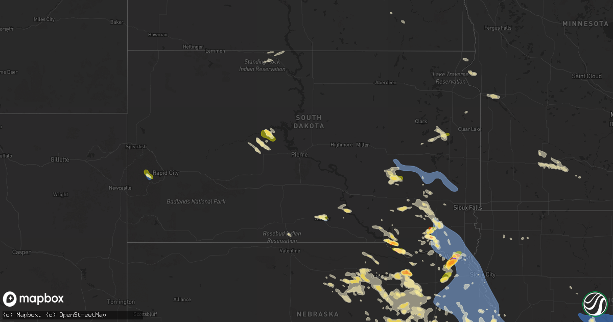
Hail Map in South Dakota on July 7, 2025
Get this storm
July 7 map
$229
one time, instant access
Download today. No call, no setup
Keep the $229
Bought the map and want the full workflow? Apply the entire $229 to a subscription within 7 days. None of it is wasted.
Every map, not just this one
This buys you this map. Subscription and you get every map we run, in the markets you choose from a few cities to whole states to nationwide. Plus real-time alerts the moment a storm fires.
Contact data
Name, contact info, occupancy, even credit band for addresses in the footprint. You go from where it hit to who to call.
Become the source they trust
Unlimited branding weather history reports on demand. You already have the documented answer ready for the property owner, and you are the one who showed up with it.
Property data and RoofTrace estimates
Pull up any address you have got, its value and the exact code rules for that jurisdiction, straight from One Click Code. Then RoofTrace estimates the squares, pitch, and roof value, priced the way you price.
Storm reports in South Dakota
South Dakota
| Date | Description |
|---|---|
| 07/07/20256:46 PM CDT | Large tree limbs down in yankton. Time estimated from radar. |
| 07/07/20256:45 PM CDT | Awos station kykn yankton municipal airport. |
| 07/07/20256:00 PM CDT | Mesonet station 163 sd rwis freeman. |
| 07/07/20255:50 PM CDT | Heavy rain and hail up to the sized of golf balls. |
| 07/07/20255:45 PM CDT | Rachell sandow called to report golf ball hail in menno. |
| 07/07/20255:45 PM CDT | Corrects previous hail report from menno. Hutchinson county em reported golf ball hail in menno. |
| 07/07/20255:25 PM CDT | Photo of lime-sized hail via social media. |
| 07/07/20254:54 PM CDT | Heavy rainfall and various sizes of hail up to golfball for about 8 minutes. |
| 07/07/20254:37 PM CDT | A local report indicates 1.00 inch wind near 1 WNW Hayti |
| 07/07/20254:14 PM CDT | Not very much hail... But some stones as big as a quarter. Heavy rain also occurred. |
| 07/07/20254:01 PM CDT | A local report indicates 64 MPH wind near 1 NE Winner |
| 07/07/20253:51 PM CDT | A local report indicates 1.00 inch wind near 1 NNW Winner |
| 07/07/20253:50 PM CDT | A local report indicates 1.00 inch wind near 2 NNW Winner |
| 07/06/20258:05 PM CDT | Estimated 50-60 mph wind gusts from police officer. Sporatic power outages due to tree damage around town. |
| 07/06/20258:05 PM CDT | Es |
| 07/06/20258:05 PM CDT | Estimated 50-60 mph wind gusts from police officer. Sporatic power outages due to tree damage aro |
| 07/06/20257:56 PM CDT | A few very strong thunderstorm winds broke two large branches out of healthy tree... And then very heavy rain started. |
| 07/06/20257:09 PM CDT | Mesonet station 197 sd rwis gayville. |
| 07/06/20257:08 PM CDT | Em estimating a wind gust around 60 mph at the intersection of 455th ave and 306th st. |
| 07/06/20257:08 PM CDT | Em estimat |
All States Impacted by Hail Map on July 7, 2025
Cities Impacted by Hail Map on July 7, 2025
- Hayes, SD
- Abernathy, TX
- McLaughlin, SD
- Lafayette, LA
- Scott, LA
- Duson, LA
- Bullhead, SD
- Wakpala, SD
- New Effington, SD
- Sisseton, SD
- Rosholt, SD
- Beardsley, MN
- Andover, OH
- Linesville, PA
- Dumont, MN
- Barry, MN
- Graceville, MN
- Forrest City, AR
- Wynne, AR
- Perryville, MO
- Only, TN
- Sedgewickville, MO
- Friedheim, MO
- Searcy, AR
- Buffalo Valley, TN
- Baxter, TN
- Oak Ridge, MO
- Gainesboro, TN
- Bloomington Springs, TN
- Port Byron, NY
- Conroe, TX
- McRae, AR
- Weedsport, NY
- Jordan, NY
- Hilham, TN
- Cookeville, TN
- Malvern, AR
- Santa Fe, TN
- Columbia, TN
- Vevay, IN
- Madison, IN
- Spearsville, LA
- El Dorado, AR
- Junction City, AR
- Akron, OH
- Allons, TN
- Livingston, TN
- Eldorado, TX
- Cuyahoga Falls, OH
- Alpena, SD
- Huron, SD
- Woonsocket, SD
- Saint Paul, NE
- Palmer, NE
- Clay Center, NE
- Wessington Springs, SD
- Ochopee, FL
- Brookfield, OH
- Fowler, OH
- Vienna, OH
- Munroe Falls, OH
- Tallmadge, OH
- Wolbach, NE
- Artesian, SD
- Cavour, SD
- Gilby, ND
- Forest River, ND
- Gregory, SD
- Auxvasse, MO
- Bradford, AR
- Burghill, OH
- Carthage, SD
- Silver Creek, NE
- Bennett, CO
- Fairfield, NE
- Minto, ND
- Strandburg, SD
- Moore Haven, FL
- Decaturville, TN
- Kingdom City, MO
- Fulton, MO
- Williamsburg, MO
- Fedora, SD
- Howard, SD
- Glenvil, NE
- Burke, SD
- McClure, IL
- Thebes, IL
- Manvel, ND
- Correll, MN
- Hermitage, AR
- Jersey, AR
- Osceola, NE
- Winner, SD
- Munich, ND
- Hannaford, ND
- Little Rock, AR
- Fairfax, SD
- Star City, AR
- Pine Bluff, AR
- Monroe, NE
- Platte Center, NE
- Briggsdale, CO
- Columbus, NE
- Letcher, SD
- Bauxite, AR
- Plankinton, SD
- Odessa, MN
- Fort Pierre, SD
- Canova, SD
- Florence, CO
- Wetmore, CO
- Beulah, CO
- Pueblo, CO
- Hill City, SD
- Cooperstown, ND
- Lake Andes, SD
- Wagner, SD
- Beaver Dams, NY
- Corning, NY
- Homer, NY
- Mcville, ND
- Port Allen, LA
- Platte, SD
- Hazel, SD
- Rapid City, SD
- Grand Forks, ND
- East Grand Forks, MN
- Winfred, SD
- Ramona, SD
- Madison, SD
- Edmore, ND
- Fairdale, ND
- Adams, ND
- Lawton, ND
- Willow Lake, SD
- Hayti, SD
- Appleton, MN
- Eminence, KY
- Smithfield, KY
- Shelbyville, KY
- Midland, SD
- Vienna, SD
- Emlenton, PA
- Mabelvale, AR
- Plain Dealing, LA
- Jamestown, ND
- Hensley, AR
- Little York, NY
- Big Flats, NY
- Horseheads, NY
- Bryant, SD
- Spencer, SD
- Mitchell, SD
- Lake Norden, SD
- Cortland, NY
- Preble, NY
- Anton, CO
- Alexandria, SD
- Boyers, PA
- Harrisville, PA
- Groton, NY
- Cimarron, NM
- Ypsilanti, ND
- Montpelier, ND
- Ocate, NM
- Emery, SD
- Humphrey, NE
- Lamy, NM
- Akron, CO
- Clarksburg, OH
- Frankfort, OH
- Tully, NY
- Alsen, ND
- Potter, NE
- Alexander, AR
- Mertzon, TX
- Cincinnatus, NY
- Truxton, NY
- Luverne, ND
- Hope, ND
- Pillsbury, ND
- Madison, NE
- Newfield, NY
- Spencer, NY
- Creston, NE
- Sidney, NE
- Oak Ridge, LA
- Brooktondale, NY
- Ithaca, NY
- Willseyville, NY
- Sterling, CO
- Doniphan, NE
- Trumbull, NE
- Mesquite, NM
- Anthony, NM
- Berino, NM
- Giltner, NE
- Lock Haven, PA
- Page, ND
- Colton, SD
- Chester, SD
- Petersburg, NE
- Iroquois, SD
- Parker, PA
- Gurley, NE
- Guadalupita, NM
- West Pittsburg, PA
- Wampum, PA
- New Castle, PA
- Otis, CO
- Dante, SD
- England, AR
- Freeville, NY
- Lindsay, NE
- Bridgewater, SD
- Niobrara, NE
- Springfield, SD
- Loxahatchee, FL
- Brookhaven, MS
- Elmira, NY
- Candor, NY
- Fordville, ND
- Cadiz, KY
- Dorchester, SC
- Avon, SD
- Orchard, CO
- Dryden, NY
- Ellwood City, PA
- Portersville, PA
- Harmony, PA
- Lynch, NE
- Lesterville, SD
- Utica, SD
- Menno, SD
- Wesson, MS
- Scotland, SD
- Lankin, ND
- Lodgepole, NE
- Verdigre, NE
- Grand Island, NE
- Edinburg, ND
- Wood River, NE
- Marion, ND
- Battle Creek, NE
- Norfolk, NE
- Geddes, SD
- Winnetoon, NE
- Clarkson, NE
- Freeman, SD
- Meadow Grove, NE
- McGraw, NY
- Yuma, CO
- Parkston, SD
- Olivet, SD
- Marion, SD
- Cairo, NE
- Monticello, AR
- Delmont, SD
- Ullin, IL
- Hodges, AL
- Humphrey, AR
- Eckley, CO
- New Raymer, CO
- Viborg, SD
- Hurley, SD
- Dalton, NE
- Irene, SD
- Volin, SD
- Yankton, SD
- Mission Hill, SD
- Centerville, SD
- Wakonda, SD
- Oshkosh, NE
- Lisbon, ND
- Eden, SD
- Nome, ND
- Oriska, ND
- Monroe, SD
- Langford, SD
- Stirum, ND
- Cogswell, ND
- Britton, SD
- Gwinner, ND
- Parker, SD
- Bradley, SD
- Lake Preston, SD
- Oldham, SD
- Aneta, ND
- Michigan, ND
- Montrose, SD
- Henry, SD
- Wallace, SD
- Forman, ND
- Fingal, ND
- Valley City, ND
- Erwin, SD
- Webster, SD
- Canistota, SD
- Roslyn, SD
- Center, NE
- Creighton, NE
- Brunswick, NE
- Chappell, NE
- Orchard, NE
- Pierce, NE
- Van Etten, NY
- Tyndall, SD
- Freedom, PA
- Tabor, SD
- Laurel, NE
- Belden, NE
- Wray, CO
- Haigler, NE
- Vernon, CO
- Idalia, CO
- Saint Francis, KS
- Mekinock, ND
- Humnoke, AR
- Randolph, NE
- Coleridge, NE
- Dickey, ND
- Seminole, TX
- Millfield, OH
- Glouster, OH
- Nelsonville, OH
- Buchtel, OH
- Athens, OH
- Page, NE
- Williamsport, OH
- Chillicothe, OH
- Logan, OH
- New Straitsville, OH
- Kanorado, KS
- Hartington, NE
- Springer, NM
- Tilden, NE
- Plainview, NE
- Royal, NE
- Newman Grove, NE
- Circleville, OH
- Erin, NY
- Ethan, SD
- Marathon, NY
- Neligh, NE
- Carroll, NE
- Talala, OK
- Salem, SD
- Indian Mound, TN
- Newcastle, NE
- Wynot, NE
- Saint Helena, NE
- Wabasso, MN
- Albion, NE
- Clements, MN
- Julesburg, CO
- Amherst, CO
- Fordyce, NE
- Redwood Falls, MN
- Vermillion, SD
- McVeytown, PA
- Atkinson, NE
- Bloomfield, NE
- Verona, ND
- Burbank, SD
- Terry, MS
- Raymond, MS
- Maskell, NE
- Brush, CO
- Moriarty, NM
- Osmond, NE
- Crofton, NE
- Dixon, NE
- Wakefield, NE
- Emerson, NE
- Inman, NE
- Springfield, MN
- Clearwater, NE
- Elgin, NE
- Sanborn, MN
- Lamberton, MN
- Stuttgart, AR
- Trementina, NM
- Hubbard, NE
- Andrews, TX
- Woodlawn, TN
- Oneill, NE
- Comfrey, MN
- Sleepy Eye, MN
- Rebersburg, PA
- Newbern, TN
- Loganton, PA
- Amesville, OH
- Thompson, ND
- Beresford, SD
- Alcester, SD
- Elk Point, SD
- Gayville, SD
- Ribera, NM
- Hanska, MN
- Saint James, MN
- Oakdale, NE
- Hospers, IA
- Sheldon, IA
- Granville, IA
- Ponca, NE
- Jefferson, SD
- Westfield, IA
- Hinton, IA
- North Sioux City, SD
- Sioux City, IA
- Alda, NE
- Pisek, ND
- Branson, CO
- Armour, SD
- Bainbridge, OH
- Vaughn, NM
- Park City, KY
- Jackson, NE
- South Sioux City, NE
- Dakota City, NE
- Sergeant Bluff, IA
- Mission, SD
- Encino, NM
- Mount Vernon, SD
- Ovid, CO
- New Concord, KY
- Ewing, NE
- Owego, NY
- La Junta, CO
- Stickney, SD
- Corsica, SD
- Spalding, NE
- Greeley, NE
- Primrose, NE
- Bird City, KS
- Venango, NE
- Lewellen, NE
- Primghar, IA
- Holyoke, CO
- Ada, MN
- Madelia, MN
- Dimock, SD
- Mill Creek, PA
- Mount Union, PA
- Las Animas, CO
- Tekamah, NE
- Salix, IA
- Decatur, NE
- Sloan, IA
- Macy, NE
- Wayne, NE
- Allen, NE
- Concord, NE
- Hoskins, NE
- Stanton, NE
- Waterbury, NE
- Winside, NE
- Homer, NE
- Pilger, NE
- Winnebago, NE
- Oakland, NE
- West Point, NE
- Bancroft, NE
- Thurston, NE
- Wisner, NE
- Lyons, NE
- Rosalie, NE
- Craig, NE
- Beemer, NE
- Walthill, NE
- Pender, NE
- Howells, NE
- Whiting, IA
- Onawa, IA
- Blencoe, IA
- Little Sioux, IA
- Dodge, NE
- Herman, NE
- North Bend, NE
- Ames, NE
- Uehling, NE
- Hooper, NE
- Scribner, NE
- Winslow, NE
- Nickerson, NE
- Fremont, NE
- Snyder, NE
- Hartley, IA
- Ord, NE
- North Loup, NE
- Chambers, NE
- Mill Hall, PA
- Big Sandy, TN
- Stewart, TN
- Sutherland, IA
- Morgan, MN
- McDonald, KS
- Arlington, NE
- Walnut Grove, MS
- Blair, NE
- Scotia, NE
- Kennard, NE
- Waverly, TN
- Cedar Rapids, NE
- Bassett, NE
- Leigh, NE
- Kim, CO
- Carthage, MS
- Missouri Valley, IA
- Schuyler, NE
- Leslie, AR
- Marshall, AR
- Omaha, NE
- Fort Calhoun, NE
- Malmo, NE
- Colon, NE
- Morse Bluff, NE
- Wahoo, NE
- Cedar Bluffs, NE
- Mead, NE
- Valley, NE
- Yutan, NE
- Ithaca, NE
- Ashland, NE
- Waterloo, NE
- Bennington, NE
- Persia, IA
- Honey Creek, IA
- Gretna, NE
- Modale, IA
- Underwood, IA
- Washington, NE
- Crescent, IA
- Elkhorn, NE
- Minden, IA
- Pisgah, IA
- Logan, IA
- Magnolia, IA
- Mondamin, IA
- Boys Town, NE
- Neola, IA
- Greenwood, NE
- Carter Lake, IA
- La Vista, NE
- Papillion, NE
- Council Bluffs, IA
- Glenwood, IA
- Bellevue, NE
- McClelland, IA
- Carson, IA
- Hancock, IA
- Oakland, IA
- Springfield, NE
- Offutt Afb, NE
- Silver City, IA
- Treynor, IA
- Crookston, MN
- Prague, NE
- New Marshfield, OH
- Capitan, NM
- Stuart, NE
- Comstock, TX
- Amelia, NE
- Red Lake Falls, MN
- Emmet, NE
- Corona, NM
- Union Furnace, OH
- Euclid, MN
- Glencoe, NM
- Ruidoso Downs, NM
- Woodburn, KY
- Bowling Green, KY
- Sims, AR
- Mifflinburg, PA
- Lewisburg, PA
- Story, AR
- Hereford, AZ
- Klamath River, CA
- David City, NE
- Bartlett, NE
- Grant, NE
- Almena, KS
- Wiggins, CO
- Weldona, CO
- Long Pine, NE
- Brainard, NE
- Bellwood, NE
- Tabor, IA
- Sidney, IA
- Chauncey, OH
- Jacksonville, OH
- Randolph, IA
- Kersey, CO
- Galeton, CO
- Ault, CO
- Dallas Center, IA
- Waukee, IA
- Lancaster, MN
- Bouton, IA
- Perry, IA
- Minburn, IA
- Peru, NE
- Saint Edward, NE
- Fort Morgan, CO
- Grimes, IA
- Watson, MO
- Rock Port, MO
- Grover, CO
- Urbandale, IA
- Seward, NE
- South Bend, NE
- Pacific Junction, IA
- Plattsmouth, NE
- Cedar Creek, NE
- Macedonia, IA
- Alvo, NE
- Louisville, NE
- Elmwood, NE
- Murdock, NE
- Mineola, IA
- Weeping Water, NE
- Unadilla, NE
- Nehawka, NE
- Avoca, NE
- Syracuse, NE
- Murray, NE
- Malvern, IA
- Manley, NE
- Percival, IA
- Nebraska City, NE
- Otoe, NE
- Henderson, IA
- Union, NE
- Thurman, IA
- Hastings, IA
- Dunbar, NE
- Farragut, IA
- Emerson, IA
- Imogene, IA
- Riverton, IA
- Hamburg, IA
- Essex, IA
- Shenandoah, IA
- Red Oak, IA
- Stanton, IA
- Clarinda, IA
- Villisca, IA
- Corning, IA
- Elliott, IA
- Griswold, IA
- Nodaway, IA
- Grant, IA
- Carbon, IA
- Prescott, IA
- Massena, IA
- Cumberland, IA
- Bridgewater, IA
- Lewis, IA
- Linwood, NE
- Long Island, KS
- Bruno, NE
- Lenora, KS
- Newport, NE
- Ericson, NE
- Genoa, NE
- Van Meter, IA
- Adel, IA
- Burwell, NE
- Craig, MO
- Patriot, OH
- Weston, NE
- Farnhamville, IA
- Lohrville, IA
- Clive, IA
- Churdan, IA
- Paton, IA
- Palmyra, NE
- Bennet, NE
- Fullerton, NE
- Belgrade, NE
- Stamford, NE
- Pencil Bluff, AR
- Warren, AR
- Auburn, NE
- Garland, NE
- Milford, NE
- Griffithville, AR
- Jamaica, IA
- Dawson, IA
- Bagley, IA
- West Des Moines, IA
- Norwalk, IA
- Prole, IA
- Linden, IA
- Yale, IA
- Booneville, IA
- Saint Charles, IA
- Cumming, IA
- Bevington, IA
- Woodward, IA
- Martensdale, IA
- Saint Marys, IA
- Indianola, IA
- Des Moines, IA
- Granger, IA
- Johnston, IA
- Windsor Heights, IA
- Polk City, IA
- Ankeny, IA
- Madrid, IA
- Huxley, IA
- Elkhart, IA
- Alleman, IA
- Cambridge, IA
- Slater, IA
- Fairfax, MO
- Pleasant Dale, NE
- Tecumseh, NE
- Lewiston, NE
- Steinauer, NE
- Martell, NE
- Hallam, NE
- Crete, NE
- Fairmont, NE
- Geneva, NE
- Brownville, NE
- Elk Creek, NE
- McCool Junction, NE
- Jacksonburg, WV
- Smithfield, WV
- Clovis, NM
- Troy, KS
- Henderson, NE
- Wathena, KS
- Milligan, NE
- Roswell, NM
- Friona, TX
- Texico, NM
- Oak, NE
- Exeter, NE
- Bovina, TX
- Farwell, TX
- Davenport, NE
- Tarkio, MO
- Grafton, NE
- Carleton, NE
- Hebron, NE
- Portales, NM
- Saint Joseph, MO
- De Kalb, MO
- Strang, NE
- Shickley, NE
- Hale Center, TX
- Deshler, NE
- Bedford, IA
- Gravity, IA
- Logan, KS
- Lubbock, TX
- Plainview, TX
- Barnard, MO
- Nelson, NE
- Albia, IA
- Oskaloosa, IA
- Courtland, KS
- Littlefork, MN
- Northboro, IA
- Coin, IA
- Blanchard, IA
- Montgomery City, MO
- New Florence, MO
- Oregon, MO
- Amazonia, MO
- Savannah, MO
- Cosby, MO
- Easton, MO
- Faucett, MO
- Agency, MO
- Elwood, KS
- Gower, MO
- Stewartsville, MO
- Plattsburg, MO
- Dearborn, MO
- Lathrop, MO
- Turney, MO
- Trimble, MO
- Holt, MO
- Smithville, MO
- Camden Point, MO
- Edgerton, MO
- Kansas City, MO
- Weston, MO
- Platte City, MO
- Liberty, MO
- Kearney, MO
- Excelsior Springs, MO
- Lawson, MO


