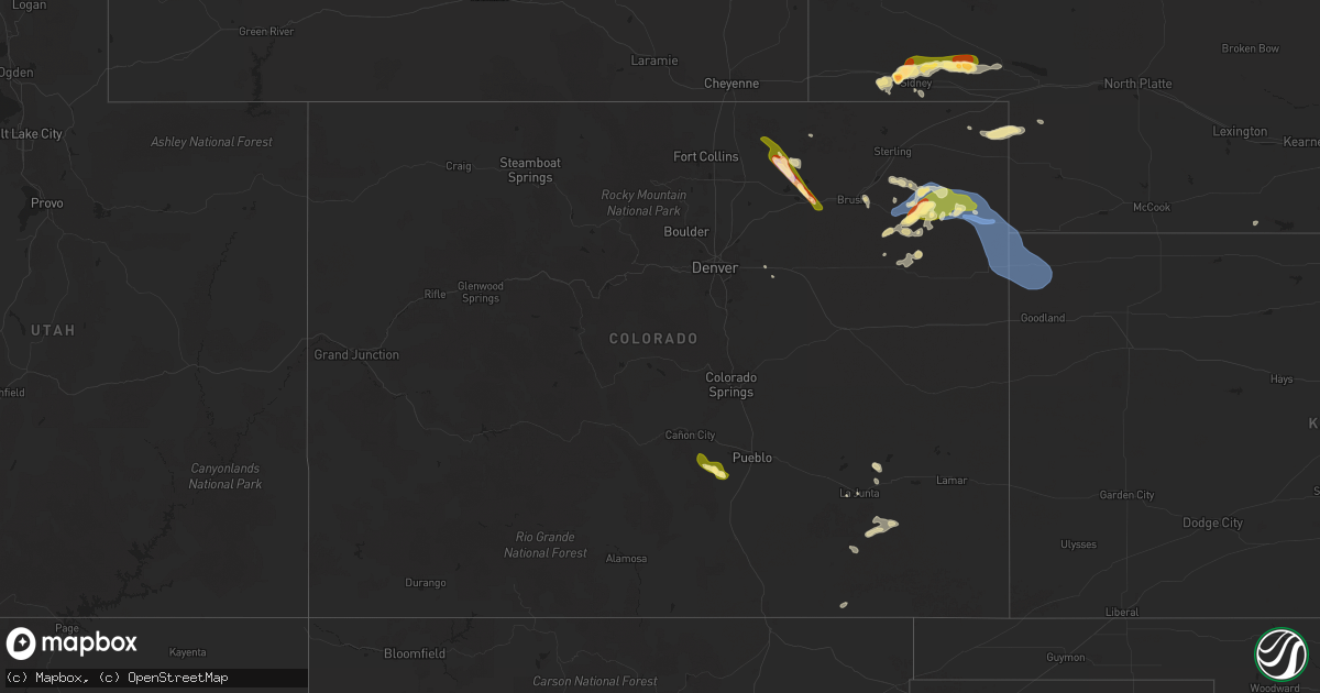
Hail Map in Colorado on July 7, 2025
Get this storm
July 7 map
$229
one time, instant access
Download today. No call, no setup
Keep the $229
Bought the map and want the full workflow? Apply the entire $229 to a subscription within 7 days. None of it is wasted.
Every map, not just this one
This buys you this map. Subscription and you get every map we run, in the markets you choose from a few cities to whole states to nationwide. Plus real-time alerts the moment a storm fires.
Contact data
Name, contact info, occupancy, even credit band for addresses in the footprint. You go from where it hit to who to call.
Become the source they trust
Unlimited branding weather history reports on demand. You already have the documented answer ready for the property owner, and you are the one who showed up with it.
Property data and RoofTrace estimates
Pull up any address you have got, its value and the exact code rules for that jurisdiction, straight from One Click Code. Then RoofTrace estimates the squares, pitch, and roof value, priced the way you price.
Storm reports in Colorado
Colorado
| Date | Description |
|---|---|
| 07/07/20256:35 PM CDT | Corrects previous tstm wnd gst report from 2 nnw wray. K2v5. ( |
| 07/07/20256:35 PM CDT | Corrects previous tstm wnd gst report from 2 nnw wray. K2v5. |
| 07/07/20256:27 PM CDT | Kcowray25. |
| 07/07/20256:26 PM CDT | Spotter network report of 60 mph wind gust via a handheld anemometer. |
| 07/07/20256:25 PM CDT | Report of some powerlines down south of wray; unknown on exact location and how many as of now. |
| 07/07/20256:25 PM CDT | K2v5. |
| 07/07/20255:53 PM CDT | Weatherlink site rdm cattle. |
| 07/07/20255:51 PM CDT | Good variety of hail sizes with quarter estimated to be the highest. |
| 07/07/20255:51 PM CDT | Good variety of hail sizes with quarter estimated to be the highest. |
| 07/07/20255:47 PM CDT | Kcoyuma34 weatherunderground site. |
| 07/07/20255:45 PM CDT | Quarter size hail ongoing in yuma. |
| 07/07/20255:40 PM CDT | Yuma county dispatch relayed a report of a tornado looking to the wnw of this location. Was n |
| 07/07/20255:40 PM CDT | Yuma county dispatch relayed a report of a tornado looking to the wnw of this location. Was not sure it was in yuma or washington county. |
| 07/07/20255:40 PM CDT | Yuma county dispatch relayed a report of a tornado looking to the wnw of this locat |
| 07/07/20255:30 PM CDT | 8 or 9 power poles down between cr45 and cr 47. Highway 59 sb is also closed in that area as well for restoration of the powerlines. |
| 07/07/20255:25 PM CDT | A local report indicates 1.50 inch wind near Otis |
| 07/07/20255:16 PM CDT | Reported via social media. Time and location estimated. |
| 07/07/20255:15 PM CDT | Retired nws employee measured 3.9cm diameter hail in otis approximately 20 minutes after it fell. |
| 07/07/20255:11 PM CDT | Video evidence of a few tennis ball or baseball sized hailstones which significantly damaged the rear windshield of a vehicle. Most stones were quarter to golf ball siz |
| 07/07/20255:09 PM CDT | A local report indicates 63 MPH wind near Akron |
| 07/07/20254:09 PM CDT | [landspout] photos of a brief landspout from 309 to 313 pm mdt. There was some visible evidence of a funnel at the cloud base despite the absence of a well defined upd |
| 07/07/20251:49 PM CDT | A local report indicates 66 MPH wind near 2 SSE Centennial |
| 07/06/202510:57 PM CDT | One small tree blown down and stripped of most of its leaves. Spotter reported some hail but did not have an estimate of size. |
All States Impacted by Hail Map on July 7, 2025
Cities Impacted by Hail Map on July 7, 2025
- Hayes, SD
- Abernathy, TX
- McLaughlin, SD
- Lafayette, LA
- Scott, LA
- Duson, LA
- Bullhead, SD
- Wakpala, SD
- New Effington, SD
- Sisseton, SD
- Rosholt, SD
- Beardsley, MN
- Andover, OH
- Linesville, PA
- Dumont, MN
- Barry, MN
- Graceville, MN
- Forrest City, AR
- Wynne, AR
- Perryville, MO
- Only, TN
- Sedgewickville, MO
- Friedheim, MO
- Searcy, AR
- Buffalo Valley, TN
- Baxter, TN
- Oak Ridge, MO
- Gainesboro, TN
- Bloomington Springs, TN
- Port Byron, NY
- Conroe, TX
- McRae, AR
- Weedsport, NY
- Jordan, NY
- Hilham, TN
- Cookeville, TN
- Malvern, AR
- Santa Fe, TN
- Columbia, TN
- Vevay, IN
- Madison, IN
- Spearsville, LA
- El Dorado, AR
- Junction City, AR
- Akron, OH
- Allons, TN
- Livingston, TN
- Eldorado, TX
- Cuyahoga Falls, OH
- Alpena, SD
- Huron, SD
- Woonsocket, SD
- Saint Paul, NE
- Palmer, NE
- Clay Center, NE
- Wessington Springs, SD
- Ochopee, FL
- Brookfield, OH
- Fowler, OH
- Vienna, OH
- Munroe Falls, OH
- Tallmadge, OH
- Wolbach, NE
- Artesian, SD
- Cavour, SD
- Gilby, ND
- Forest River, ND
- Gregory, SD
- Auxvasse, MO
- Bradford, AR
- Burghill, OH
- Carthage, SD
- Silver Creek, NE
- Bennett, CO
- Fairfield, NE
- Minto, ND
- Strandburg, SD
- Moore Haven, FL
- Decaturville, TN
- Kingdom City, MO
- Fulton, MO
- Williamsburg, MO
- Fedora, SD
- Howard, SD
- Glenvil, NE
- Burke, SD
- McClure, IL
- Thebes, IL
- Manvel, ND
- Correll, MN
- Hermitage, AR
- Jersey, AR
- Osceola, NE
- Winner, SD
- Munich, ND
- Hannaford, ND
- Little Rock, AR
- Fairfax, SD
- Star City, AR
- Pine Bluff, AR
- Monroe, NE
- Platte Center, NE
- Briggsdale, CO
- Columbus, NE
- Letcher, SD
- Bauxite, AR
- Plankinton, SD
- Odessa, MN
- Fort Pierre, SD
- Canova, SD
- Florence, CO
- Wetmore, CO
- Beulah, CO
- Pueblo, CO
- Hill City, SD
- Cooperstown, ND
- Lake Andes, SD
- Wagner, SD
- Beaver Dams, NY
- Corning, NY
- Homer, NY
- Mcville, ND
- Port Allen, LA
- Platte, SD
- Hazel, SD
- Rapid City, SD
- Grand Forks, ND
- East Grand Forks, MN
- Winfred, SD
- Ramona, SD
- Madison, SD
- Edmore, ND
- Fairdale, ND
- Adams, ND
- Lawton, ND
- Willow Lake, SD
- Hayti, SD
- Appleton, MN
- Eminence, KY
- Smithfield, KY
- Shelbyville, KY
- Midland, SD
- Vienna, SD
- Emlenton, PA
- Mabelvale, AR
- Plain Dealing, LA
- Jamestown, ND
- Hensley, AR
- Little York, NY
- Big Flats, NY
- Horseheads, NY
- Bryant, SD
- Spencer, SD
- Mitchell, SD
- Lake Norden, SD
- Cortland, NY
- Preble, NY
- Anton, CO
- Alexandria, SD
- Boyers, PA
- Harrisville, PA
- Groton, NY
- Cimarron, NM
- Ypsilanti, ND
- Montpelier, ND
- Ocate, NM
- Emery, SD
- Humphrey, NE
- Lamy, NM
- Akron, CO
- Clarksburg, OH
- Frankfort, OH
- Tully, NY
- Alsen, ND
- Potter, NE
- Alexander, AR
- Mertzon, TX
- Cincinnatus, NY
- Truxton, NY
- Luverne, ND
- Hope, ND
- Pillsbury, ND
- Madison, NE
- Newfield, NY
- Spencer, NY
- Creston, NE
- Sidney, NE
- Oak Ridge, LA
- Brooktondale, NY
- Ithaca, NY
- Willseyville, NY
- Sterling, CO
- Doniphan, NE
- Trumbull, NE
- Mesquite, NM
- Anthony, NM
- Berino, NM
- Giltner, NE
- Lock Haven, PA
- Page, ND
- Colton, SD
- Chester, SD
- Petersburg, NE
- Iroquois, SD
- Parker, PA
- Gurley, NE
- Guadalupita, NM
- West Pittsburg, PA
- Wampum, PA
- New Castle, PA
- Otis, CO
- Dante, SD
- England, AR
- Freeville, NY
- Lindsay, NE
- Bridgewater, SD
- Niobrara, NE
- Springfield, SD
- Loxahatchee, FL
- Brookhaven, MS
- Elmira, NY
- Candor, NY
- Fordville, ND
- Cadiz, KY
- Dorchester, SC
- Avon, SD
- Orchard, CO
- Dryden, NY
- Ellwood City, PA
- Portersville, PA
- Harmony, PA
- Lynch, NE
- Lesterville, SD
- Utica, SD
- Menno, SD
- Wesson, MS
- Scotland, SD
- Lankin, ND
- Lodgepole, NE
- Verdigre, NE
- Grand Island, NE
- Edinburg, ND
- Wood River, NE
- Marion, ND
- Battle Creek, NE
- Norfolk, NE
- Geddes, SD
- Winnetoon, NE
- Clarkson, NE
- Freeman, SD
- Meadow Grove, NE
- McGraw, NY
- Yuma, CO
- Parkston, SD
- Olivet, SD
- Marion, SD
- Cairo, NE
- Monticello, AR
- Delmont, SD
- Ullin, IL
- Hodges, AL
- Humphrey, AR
- Eckley, CO
- New Raymer, CO
- Viborg, SD
- Hurley, SD
- Dalton, NE
- Irene, SD
- Volin, SD
- Yankton, SD
- Mission Hill, SD
- Centerville, SD
- Wakonda, SD
- Oshkosh, NE
- Lisbon, ND
- Eden, SD
- Nome, ND
- Oriska, ND
- Monroe, SD
- Langford, SD
- Stirum, ND
- Cogswell, ND
- Britton, SD
- Gwinner, ND
- Parker, SD
- Bradley, SD
- Lake Preston, SD
- Oldham, SD
- Aneta, ND
- Michigan, ND
- Montrose, SD
- Henry, SD
- Wallace, SD
- Forman, ND
- Fingal, ND
- Valley City, ND
- Erwin, SD
- Webster, SD
- Canistota, SD
- Roslyn, SD
- Center, NE
- Creighton, NE
- Brunswick, NE
- Chappell, NE
- Orchard, NE
- Pierce, NE
- Van Etten, NY
- Tyndall, SD
- Freedom, PA
- Tabor, SD
- Laurel, NE
- Belden, NE
- Wray, CO
- Haigler, NE
- Vernon, CO
- Idalia, CO
- Saint Francis, KS
- Mekinock, ND
- Humnoke, AR
- Randolph, NE
- Coleridge, NE
- Dickey, ND
- Seminole, TX
- Millfield, OH
- Glouster, OH
- Nelsonville, OH
- Buchtel, OH
- Athens, OH
- Page, NE
- Williamsport, OH
- Chillicothe, OH
- Logan, OH
- New Straitsville, OH
- Kanorado, KS
- Hartington, NE
- Springer, NM
- Tilden, NE
- Plainview, NE
- Royal, NE
- Newman Grove, NE
- Circleville, OH
- Erin, NY
- Ethan, SD
- Marathon, NY
- Neligh, NE
- Carroll, NE
- Talala, OK
- Salem, SD
- Indian Mound, TN
- Newcastle, NE
- Wynot, NE
- Saint Helena, NE
- Wabasso, MN
- Albion, NE
- Clements, MN
- Julesburg, CO
- Amherst, CO
- Fordyce, NE
- Redwood Falls, MN
- Vermillion, SD
- McVeytown, PA
- Atkinson, NE
- Bloomfield, NE
- Verona, ND
- Burbank, SD
- Terry, MS
- Raymond, MS
- Maskell, NE
- Brush, CO
- Moriarty, NM
- Osmond, NE
- Crofton, NE
- Dixon, NE
- Wakefield, NE
- Emerson, NE
- Inman, NE
- Springfield, MN
- Clearwater, NE
- Elgin, NE
- Sanborn, MN
- Lamberton, MN
- Stuttgart, AR
- Trementina, NM
- Hubbard, NE
- Andrews, TX
- Woodlawn, TN
- Oneill, NE
- Comfrey, MN
- Sleepy Eye, MN
- Rebersburg, PA
- Newbern, TN
- Loganton, PA
- Amesville, OH
- Thompson, ND
- Beresford, SD
- Alcester, SD
- Elk Point, SD
- Gayville, SD
- Ribera, NM
- Hanska, MN
- Saint James, MN
- Oakdale, NE
- Hospers, IA
- Sheldon, IA
- Granville, IA
- Ponca, NE
- Jefferson, SD
- Westfield, IA
- Hinton, IA
- North Sioux City, SD
- Sioux City, IA
- Alda, NE
- Pisek, ND
- Branson, CO
- Armour, SD
- Bainbridge, OH
- Vaughn, NM
- Park City, KY
- Jackson, NE
- South Sioux City, NE
- Dakota City, NE
- Sergeant Bluff, IA
- Mission, SD
- Encino, NM
- Mount Vernon, SD
- Ovid, CO
- New Concord, KY
- Ewing, NE
- Owego, NY
- La Junta, CO
- Stickney, SD
- Corsica, SD
- Spalding, NE
- Greeley, NE
- Primrose, NE
- Bird City, KS
- Venango, NE
- Lewellen, NE
- Primghar, IA
- Holyoke, CO
- Ada, MN
- Madelia, MN
- Dimock, SD
- Mill Creek, PA
- Mount Union, PA
- Las Animas, CO
- Tekamah, NE
- Salix, IA
- Decatur, NE
- Sloan, IA
- Macy, NE
- Wayne, NE
- Allen, NE
- Concord, NE
- Hoskins, NE
- Stanton, NE
- Waterbury, NE
- Winside, NE
- Homer, NE
- Pilger, NE
- Winnebago, NE
- Oakland, NE
- West Point, NE
- Bancroft, NE
- Thurston, NE
- Wisner, NE
- Lyons, NE
- Rosalie, NE
- Craig, NE
- Beemer, NE
- Walthill, NE
- Pender, NE
- Howells, NE
- Whiting, IA
- Onawa, IA
- Blencoe, IA
- Little Sioux, IA
- Dodge, NE
- Herman, NE
- North Bend, NE
- Ames, NE
- Uehling, NE
- Hooper, NE
- Scribner, NE
- Winslow, NE
- Nickerson, NE
- Fremont, NE
- Snyder, NE
- Hartley, IA
- Ord, NE
- North Loup, NE
- Chambers, NE
- Mill Hall, PA
- Big Sandy, TN
- Stewart, TN
- Sutherland, IA
- Morgan, MN
- McDonald, KS
- Arlington, NE
- Walnut Grove, MS
- Blair, NE
- Scotia, NE
- Kennard, NE
- Waverly, TN
- Cedar Rapids, NE
- Bassett, NE
- Leigh, NE
- Kim, CO
- Carthage, MS
- Missouri Valley, IA
- Schuyler, NE
- Leslie, AR
- Marshall, AR
- Omaha, NE
- Fort Calhoun, NE
- Malmo, NE
- Colon, NE
- Morse Bluff, NE
- Wahoo, NE
- Cedar Bluffs, NE
- Mead, NE
- Valley, NE
- Yutan, NE
- Ithaca, NE
- Ashland, NE
- Waterloo, NE
- Bennington, NE
- Persia, IA
- Honey Creek, IA
- Gretna, NE
- Modale, IA
- Underwood, IA
- Washington, NE
- Crescent, IA
- Elkhorn, NE
- Minden, IA
- Pisgah, IA
- Logan, IA
- Magnolia, IA
- Mondamin, IA
- Boys Town, NE
- Neola, IA
- Greenwood, NE
- Carter Lake, IA
- La Vista, NE
- Papillion, NE
- Council Bluffs, IA
- Glenwood, IA
- Bellevue, NE
- McClelland, IA
- Carson, IA
- Hancock, IA
- Oakland, IA
- Springfield, NE
- Offutt Afb, NE
- Silver City, IA
- Treynor, IA
- Crookston, MN
- Prague, NE
- New Marshfield, OH
- Capitan, NM
- Stuart, NE
- Comstock, TX
- Amelia, NE
- Red Lake Falls, MN
- Emmet, NE
- Corona, NM
- Union Furnace, OH
- Euclid, MN
- Glencoe, NM
- Ruidoso Downs, NM
- Woodburn, KY
- Bowling Green, KY
- Sims, AR
- Mifflinburg, PA
- Lewisburg, PA
- Story, AR
- Hereford, AZ
- Klamath River, CA
- David City, NE
- Bartlett, NE
- Grant, NE
- Almena, KS
- Wiggins, CO
- Weldona, CO
- Long Pine, NE
- Brainard, NE
- Bellwood, NE
- Tabor, IA
- Sidney, IA
- Chauncey, OH
- Jacksonville, OH
- Randolph, IA
- Kersey, CO
- Galeton, CO
- Ault, CO
- Dallas Center, IA
- Waukee, IA
- Lancaster, MN
- Bouton, IA
- Perry, IA
- Minburn, IA
- Peru, NE
- Saint Edward, NE
- Fort Morgan, CO
- Grimes, IA
- Watson, MO
- Rock Port, MO
- Grover, CO
- Urbandale, IA
- Seward, NE
- South Bend, NE
- Pacific Junction, IA
- Plattsmouth, NE
- Cedar Creek, NE
- Macedonia, IA
- Alvo, NE
- Louisville, NE
- Elmwood, NE
- Murdock, NE
- Mineola, IA
- Weeping Water, NE
- Unadilla, NE
- Nehawka, NE
- Avoca, NE
- Syracuse, NE
- Murray, NE
- Malvern, IA
- Manley, NE
- Percival, IA
- Nebraska City, NE
- Otoe, NE
- Henderson, IA
- Union, NE
- Thurman, IA
- Hastings, IA
- Dunbar, NE
- Farragut, IA
- Emerson, IA
- Imogene, IA
- Riverton, IA
- Hamburg, IA
- Essex, IA
- Shenandoah, IA
- Red Oak, IA
- Stanton, IA
- Clarinda, IA
- Villisca, IA
- Corning, IA
- Elliott, IA
- Griswold, IA
- Nodaway, IA
- Grant, IA
- Carbon, IA
- Prescott, IA
- Massena, IA
- Cumberland, IA
- Bridgewater, IA
- Lewis, IA
- Linwood, NE
- Long Island, KS
- Bruno, NE
- Lenora, KS
- Newport, NE
- Ericson, NE
- Genoa, NE
- Van Meter, IA
- Adel, IA
- Burwell, NE
- Craig, MO
- Patriot, OH
- Weston, NE
- Farnhamville, IA
- Lohrville, IA
- Clive, IA
- Churdan, IA
- Paton, IA
- Palmyra, NE
- Bennet, NE
- Fullerton, NE
- Belgrade, NE
- Stamford, NE
- Pencil Bluff, AR
- Warren, AR
- Auburn, NE
- Garland, NE
- Milford, NE
- Griffithville, AR
- Jamaica, IA
- Dawson, IA
- Bagley, IA
- West Des Moines, IA
- Norwalk, IA
- Prole, IA
- Linden, IA
- Yale, IA
- Booneville, IA
- Saint Charles, IA
- Cumming, IA
- Bevington, IA
- Woodward, IA
- Martensdale, IA
- Saint Marys, IA
- Indianola, IA
- Des Moines, IA
- Granger, IA
- Johnston, IA
- Windsor Heights, IA
- Polk City, IA
- Ankeny, IA
- Madrid, IA
- Huxley, IA
- Elkhart, IA
- Alleman, IA
- Cambridge, IA
- Slater, IA
- Fairfax, MO
- Pleasant Dale, NE
- Tecumseh, NE
- Lewiston, NE
- Steinauer, NE
- Martell, NE
- Hallam, NE
- Crete, NE
- Fairmont, NE
- Geneva, NE
- Brownville, NE
- Elk Creek, NE
- McCool Junction, NE
- Jacksonburg, WV
- Smithfield, WV
- Clovis, NM
- Troy, KS
- Henderson, NE
- Wathena, KS
- Milligan, NE
- Roswell, NM
- Friona, TX
- Texico, NM
- Oak, NE
- Exeter, NE
- Bovina, TX
- Farwell, TX
- Davenport, NE
- Tarkio, MO
- Grafton, NE
- Carleton, NE
- Hebron, NE
- Portales, NM
- Saint Joseph, MO
- De Kalb, MO
- Strang, NE
- Shickley, NE
- Hale Center, TX
- Deshler, NE
- Bedford, IA
- Gravity, IA
- Logan, KS
- Lubbock, TX
- Plainview, TX
- Barnard, MO
- Nelson, NE
- Albia, IA
- Oskaloosa, IA
- Courtland, KS
- Littlefork, MN
- Northboro, IA
- Coin, IA
- Blanchard, IA
- Montgomery City, MO
- New Florence, MO
- Oregon, MO
- Amazonia, MO
- Savannah, MO
- Cosby, MO
- Easton, MO
- Faucett, MO
- Agency, MO
- Elwood, KS
- Gower, MO
- Stewartsville, MO
- Plattsburg, MO
- Dearborn, MO
- Lathrop, MO
- Turney, MO
- Trimble, MO
- Holt, MO
- Smithville, MO
- Camden Point, MO
- Edgerton, MO
- Kansas City, MO
- Weston, MO
- Platte City, MO
- Liberty, MO
- Kearney, MO
- Excelsior Springs, MO
- Lawson, MO


