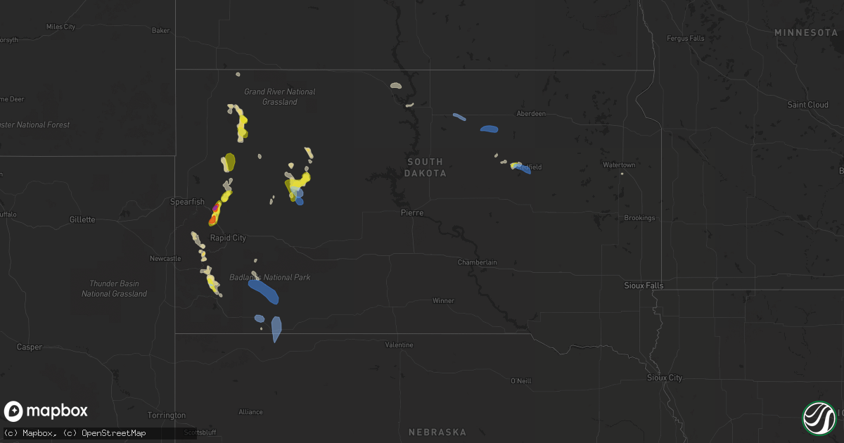
Hail Map in South Dakota on July 7, 2022
Get this storm
July 7 map
$229
one time, instant access
Download today. No call, no setup
Keep the $229
Bought the map and want the full workflow? Apply the entire $229 to a subscription within 7 days. None of it is wasted.
Every map, not just this one
This buys you this map. Subscription and you get every map we run, in the markets you choose from a few cities to whole states to nationwide. Plus real-time alerts the moment a storm fires.
Contact data
Name, contact info, occupancy, even credit band for addresses in the footprint. You go from where it hit to who to call.
Become the source they trust
Unlimited branding weather history reports on demand. You already have the documented answer ready for the property owner, and you are the one who showed up with it.
Property data and RoofTrace estimates
Pull up any address you have got, its value and the exact code rules for that jurisdiction, straight from One Click Code. Then RoofTrace estimates the squares, pitch, and roof value, priced the way you price.
Storm reports in South Dakota
South Dakota
| Date | Description |
|---|---|
| 07/07/20225:48 PM CDT | Reported the wind gusts were shaking a mobile home. |
| 07/07/20224:13 PM CDT | A local report indicates 61 MPH wind near 1 W WIND CAVE VISITORS |
| 07/07/20224:00 PM CDT | A local report indicates 61 MPH wind near 1 W WIND CAVE VISITORS |
| 07/07/202212:33 PM CDT | A local report indicates 1.00 inch wind near 1 W ZELL |
| 07/07/202210:07 AM CDT | Mesonet station 216 bowdle |
| 07/07/20227:26 AM CDT | At 1226 PM CDT, a severe thunderstorm was located over Zell, or 8 miles west of Redfield, moving northeast at 20 mph. HAZARD...60 mph wind gusts and quarter size hail. SOURCE...Radar indicated. IMPACT...Hail damage to vehicles is expected. Expect wind damage to roofs, siding, and trees. This severe thunderstorm will be near... Redfield around 1245 PM CDT.Other locations in the path of this severe thunderstorm includeAthol. |
| 07/07/20226:22 AM CDT | At 1122 AM CDT, a severe thunderstorm was located near Blumengard Colony, or 12 miles south of Ipswich, moving east at 20 mph. HAZARD...60 mph wind gusts. SOURCE...Radar indicated. IMPACT...Expect damage to roofs, siding, and trees. This severe thunderstorm will be near... Pembrook Colony around 1135 AM CDT.Other locations in the path of this severe thunderstorm includeCresbard. |
| 07/07/20223:00 AM CDT | At 800 PM MDT, a severe thunderstorm was located near Dalton Lake, or 10 miles south of Sturgis, moving south at 20 mph. HAZARD...Golf ball size hail and 60 mph wind gusts. SOURCE...Radar indicated. IMPACT...People and animals outdoors will be injured. Expect hail damage to roofs, siding, windows, and vehicles. Expect wind damage to roofs, siding, and trees. Locations impacted include... Summerset, Johnson Siding, Nemo, Piedmont, Silver City, Hisega, Mystic, Pactola Reservoir and Dalton Lake.This includes Interstate 90 in South Dakota between Mile Markers 41and 48. |
| 07/07/20222:23 AM CDT | At 722 PM MDT, a severe thunderstorm was located 3 miles northeast of Fort Meade, or 4 miles east of Sturgis, moving southwest at 20 mph. HAZARD...Half dollar size hail. SOURCE...Radar indicated. IMPACT...Damage to vehicles is expected. Locations impacted include... Sturgis, Tilford, Bear Butte State Park and Fort Meade. This includes Interstate 90 in South Dakota between Mile Markers 32and 42. |
| 07/07/20221:57 AM CDT | A local report indicates 59 MPH wind near 10 W EDGEMONT |
| 07/07/20221:54 AM CDT | At 653 PM MDT, a severe thunderstorm was located 10 miles southeast of Vale, or 16 miles northeast of Sturgis, moving south at 15 mph. HAZARD...Quarter size hail. SOURCE...Radar indicated. IMPACT...Damage to vehicles is expected. This severe thunderstorm will remain over mainly rural areas of southwestern Meade County. |
| 07/07/202212:43 AM CDT | At 542 PM MDT, severe thunderstorms were located along a line extending from near Batesland to 8 miles north of Rushville to near Red Cloud Campground, moving southeast at 25 mph. HAZARD...60 mph wind gusts and penny size hail. SOURCE...Radar indicated. IMPACT...Expect damage to roofs, siding, and trees. Locations impacted include... Gordon, Rushville, Hay Springs, Clinton, Lone Butte, Irwin, Mount Maria, Walgren Lake State Recreation Area, Shell Lake State Wildlife Management Area, Bayonne, and Hoover Lake This includes the following highways... Highway 20 between mile markers 75 and 118. Highway 250 between mile markers 32 and 48. |
| 07/07/202212:15 AM CDT | At 515 PM MDT, severe thunderstorms were located along a line extending from 4 miles northwest of Yellow Bear Canyon to 3 miles southeast of Porcupine Butte Housing to 4 miles southwest of White Clay, moving southeast at 25 mph. HAZARD...60 mph wind gusts. SOURCE...Radar indicated. IMPACT...Expect damage to roofs, siding, and trees. Locations impacted include... Pine Ridge, Martin, Porcupine, Allen, Wounded Knee, Batesland, Wakpamni, Swett, LaCreek North Housing, Sunrise Housing, Calico, Wolf Creek Housing, Porcupine Butte Housing, Yellow Bear Canyon, southwestern Lacreek Wildlife Refuge and Pine Ridge Reservation. |
| 07/06/202211:56 PM CDT | At 455 PM MDT, a severe thunderstorm was located near Chadron Airport, or 9 miles west of Chadron, moving southeast at 20 mph. HAZARD...60 mph wind gusts and quarter size hail. SOURCE...Radar indicated. IMPACT...Hail damage to vehicles is expected. Expect wind damage to roofs, siding, and trees. Locations impacted include... Chadron, Red Cloud Campground, Chadron Airport, Chadron Campground, Whitney and Chadron St Park. |
| 07/06/202211:50 PM CDT | At 449 PM MDT, a severe thunderstorm was located over Plainview, or 30 miles south of Faith, moving south at 25 mph. HAZARD...60 mph wind gusts and quarter size hail. SOURCE...Radar indicated. IMPACT...Hail damage to vehicles is expected. Expect wind damage to roofs, siding, and trees. Locations impacted include... Plainview, Marcus, Bridger, Howes, White Owl and Takini. |
| 07/06/202211:42 PM CDT | At 442 PM MDT, severe thunderstorms were located along a line extending from near Rockyford to near Oglala to near Whitney Lake, moving southeast at 30 mph. HAZARD...60 mph wind gusts and penny size hail. SOURCE...Radar indicated. IMPACT...Expect damage to roofs, siding, and trees. Locations impacted include... Rushville, Hay Springs, White Clay, Pine Ridge, Intersection of Highway 87 and Craven Creek Road, Metcalf State Wildlife Management Area, Intersection of Beaver Creek Road and White Clay Creek Road, Intersection of Highway 87 and Larabee Road, Mount Maria, Intersection of Highway 87 and Antelope Road and Walgren Lake State Recreation Area.This includes the following highways... Highway 20 between mile markers 74 and 95. Highway 250 between mile markers 46 and 48. |
| 07/06/202211:35 PM CDT | At 435 PM MDT, a severe thunderstorm was located 4 miles northwest of Slim Buttes Housing, or 15 miles northwest of Pine Ridge, moving southeast at 25 mph. HAZARD...60 mph wind gusts and penny size hail. SOURCE...Radar indicated. IMPACT...Expect damage to roofs, siding, and trees. Locations impacted include... Pine Ridge, Oglala, Loneman, Number 4, South Lakeside, Calico, Wolf Creek Housing, Slim Butte and Slim Buttes Housing. |
| 07/06/202211:31 PM CDT | At 431 PM MDT, a severe thunderstorm was located 4 miles southeast of Sheep Buttes, or 35 miles southeast of Buffalo, moving southeast at 20 mph. HAZARD...60 mph wind gusts and half dollar size hail. SOURCE...Radar indicated. IMPACT...Hail damage to vehicles is expected. Expect wind damage to roofs, siding, and trees. Locations impacted include... Zeona and Sheep Buttes. |
| 07/06/202211:11 PM CDT | At 411 PM MDT, a severe thunderstorm was located over southwestern Badlands National Park, or 35 miles north of Pine Ridge, moving southeast at 30 mph. HAZARD...60 mph wind gusts and penny size hail. SOURCE...Radar indicated. IMPACT...Expect damage to roofs, siding, and trees. This severe thunderstorm will be near... Rockyford around 425 PM MDT. Lonesome Valley around 430 PM MDT.Other locations in the path of this severe thunderstorm includeThunder Valley, Goose Neck Housing, Sharps Corner, Evergreen,Porcupine and Porcupine Butte Housing. |
| 07/06/20229:54 PM CDT | At 254 PM MDT, a severe thunderstorm was located over western Wind Cave National Park, or 10 miles north of Hot Springs, moving south at 15 mph. HAZARD...60 mph wind gusts and half dollar size hail. SOURCE...Radar indicated. IMPACT...Hail damage to vehicles is expected. Expect wind damage to roofs, siding, and trees. Locations impacted include... Hot Springs, Buffalo Gap, Pringle, Wind Cave National Park, Maverick Junction, Cold Brook Reservoir, northwestern Angostura Reservoir and southern Custer State Park. |
| 07/06/20228:26 PM CDT | A local report indicates 2.00 inch wind near 5 E STURGIS |
All States Impacted by Hail Map on July 7, 2022
Cities Impacted by Hail Map on July 7, 2022
- Shelby, MT
- Somers, MT
- Lakeside, MT
- Kalispell, MT
- Highwood, MT
- Floweree, MT
- Fort Benton, MT
- Upton, WY
- Choteau, MT
- Howes, SD
- Trout Creek, MT
- Almont, ND
- Glen Ullin, ND
- Grover, CO
- Carpenter, WY
- Mud Butte, SD
- Columbia Falls, MT
- Fairfield, MT
- Ten Sleep, WY
- Raynesford, MT
- Geyser, MT
- Meeteetse, WY
- Cody, WY
- Geraldine, MT
- Canyon Creek, MT
- Wise River, MT
- Charlo, MT
- Arlee, MT
- Havre, MT
- Winifred, MT
- Valier, MT
- Union Center, SD
- Dupree, SD
- Faith, SD
- Elliston, MT
- Avon, MT
- Marysville, MT
- Condon, MT
- Belt, MT
- Great Falls, MT
- Reva, SD
- Buffalo, SD
- Newell, SD
- Sunburst, MT
- Whitlash, MT
- Sheridan, WY
- Elgin, ND
- Elmo, MT
- Kila, MT
- Dayton, MT
- Proctor, MT
- Lonepine, MT
- Hot Springs, MT
- Polson, MT
- Big Arm, MT
- Rollins, MT
- White Plains, KY
- Dutton, MT
- Chugwater, WY
- Wheatland, WY
- Cut Bank, MT
- Hilger, MT
- Lewistown, MT
- Browning, MT
- Lincoln, MT
- Enning, SD
- Denton, MT
- Kaycee, WY
- Corvallis, MT
- Stevensville, MT
- Victor, MT
- Missoula, MT
- Mobridge, SD
- Ralph, SD
- Sturgis, SD
- Nemo, SD
- Piedmont, SD
- Wolf Creek, MT
- Tower Hill, IL
- Harrison, NE
- Bynum, MT
- Vaughn, MT
- Power, MT
- Black Eagle, MT
- Sun River, MT
- Fort Shaw, MT
- Elizabethtown, IL
- Herod, IL
- Wakpala, SD
- Bendena, KS
- Troy, KS
- Robinson, KS
- Highland, KS
- Denton, KS
- Jordan, MT
- Fort Peck, MT
- Buffalo Gap, SD
- Jay Em, WY
- Auburn, NE
- Johnson, NE
- Brock, NE
- Gillette, WY
- Chadron, NE
- Whitney, NE
- Clinton, MT
- Florence, MT
- Charleston, MO
- Hendersonville, TN
- Gallatin, TN
- Bonner, MT
- Torrington, WY
- Morrill, NE
- Dawson, NE
- Dalton, NE
- Broadwater, NE
- Merino, CO
- Wright, WY
- Dillon, MT
- Thompson Falls, MT
- Vale, SD
- Snyder, CO
- Hermosa, SD
- Keystone, SD
- Custer, SD
- Hill City, SD
- Rush, CO
- Ordway, CO
- Shawmut, MT
- Melville, MT
- Perryville, KY
- Parksville, KY
- Gravel Switch, KY
- Springfield, KY
- Danville, KY
- Oregon, MO
- Forest City, MO
- Rockham, SD
- Faulkton, SD
- Drummond, MT
- Lexington, TN
- Merriman, NE
- Hugo, CO
- Brunswick, GA
- Kim, CO
- Mcminnville, TN
- Morrison, TN
- Woodbury, TN
- Flowery Branch, GA
- Chattanooga, TN
- Bethpage, TN
- Roebuck, SC
- Pauline, SC
- Model, CO
- Trilla, IL
- Neoga, IL
- Spartanburg, SC
- Cookeville, TN
- Gallant, AL
- Altoona, AL
- Oneonta, AL
- Darden, TN
- Parsons, TN
- Buford, GA
- Suwanee, GA
- Cumming, GA
- Spring Lake, NC
- Fort Bragg, NC
- Pope Army Airfield, NC
- Eatonton, GA
- Watertown, TN
- Brush Creek, TN
- Brentwood, TN
- Raleigh, NC
- Menlo, GA
- Rising Fawn, GA
- Smithville, TN
- Sparta, TN
- Holland, KY
- Scottsville, KY
- Maryville, TN
- Longdale, OK
- Seiling, OK
- Signal Mountain, TN
- Madison, GA
- Newborn, GA
- Ryegate, MT
- Bayard, NE
- Rye, CO
- Colorado City, CO
- Pueblo, CO
- Greenville, KY
- Limon, CO
- Glenallen, MO
- Marble Hill, MO
- Patton, MO
- Rock Island, TN
- Ellington, MO
- Tompkinsville, KY
- Portland, TN
- Seeley Lake, MT
- Dixon, MT
- Whitewater, MO
- Crofton, KY
- Sedan, NM
- Scottsboro, AL
- Woodville, AL
- Hollytree, AL
- Keystone Heights, FL
- Melrose, FL
- Goodlettsville, TN
- White House, TN
- Joelton, TN
- Westmoreland, TN
- Greenbrier, TN
- Cottontown, TN
- Louisville, GA
- Madison, TN
- Old Hickory, TN
- Laceys Spring, AL
- Lead, SD
- Harrisonville, MO
- Lavina, MT
- Edinburg, IL
- Pawnee, IL
- Rochester, IL
- Pritchett, CO
- Las Animas, CO
- Colorado Springs, CO
- Penrose, CO
- Florissant, CO
- Harrisburg, NE
- Gamaliel, KY
- Fountain Run, KY
- Edmonton, KY
- Burkesville, KY
- Greenville, MO
- Marquand, MO
- Easley, SC
- Pickens, SC
- Marietta, SC
- Jansen, NE
- Fairbury, NE
- Summerville, GA
- Gainesville, GA
- Milledgeville, GA
- Thompsons Station, TN
- Franklin, TN
- Fairview, OK
- Tulia, TX
- Monticello, GA
- Mansfield, GA
- Shelbyville, TN
- Bell Buckle, TN
- Enoree, SC
- Gray Court, SC
- Woodruff, SC
- Auburn, KY
- Braselton, GA
- Lebanon, TN
- Ronan, MT
- Hazlehurst, GA
- Currie, NC
- Pleasant Shade, TN
- Walland, TN
- Garnett, KS
- Norris City, IL
- Midway, GA
- Fort Myers, FL
- Pine Bluffs, WY
- Bushnell, NE
- Maitland, MO
- Fillmore, MO
- Reynolds, NE
- Punta Gorda, FL
- Paint Rock, AL
- Gainesboro, TN
- Carthage, TN
- Elmwood, TN
- Poplar Bluff, MO
- Steele, AL
- Rainbow City, AL
- Ashville, AL
- Manchester, TN
- Nancy, KY
- Russell Springs, KY
- Haddock, GA
- Gray, GA
- Helena, MO
- Savannah, MO
- Redfield, SD
- Dimmitt, TX
- Amity, MO
- Rea, MO
- Union Star, MO
- Rosendale, MO
- Cosby, MO
- Maysville, MO
- Springfield, CO
- Branson, CO
- Lyons, CO
- Wray, CO
- Hunnewell, MO
- Emden, MO
- Selma, NC
- Kenly, NC
- Granville, TN
- Buffalo Valley, TN
- Chestnut Mound, TN
- Riddleton, TN
- Campo, CO
- Bowling Green, KY
- Alvaton, KY
- College Grove, TN
- Spring Hill, TN
- Camden, IL
- Littleton, IL
- Plymouth, IL
- Cheyenne, WY
- Haleyville, AL
- Rushville, IL
- Huntsville, IL
- Primm Springs, TN
- Beulah, CO
- Sylvester, GA
- Poulan, GA
- Amsterdam, MO
- Parker, KS
- Centerville, KS
- Kit Carson, CO
- Fort Morgan, CO
- Clayton, NC
- Gurley, AL
- Trenton, AL
- Chaffee, MO
- Owens Cross Roads, AL
- Walsh, CO
- Somerville, AL
- Bethany, IL
- Hestand, KY
- Moss, TN
- Bardwell, KY
- Arlington, KY
- Ellabell, GA
- Silver Point, TN
- Rockledge, GA
- Townsend, GA
- Walsenburg, CO
- Central City, KY
- Drakesboro, KY
- Mahaska, KS
- Hubbell, NE
- Liberty, TN
- Plains, GA
- Fayetteville, TN
- Mulberry, TN
- Flintville, TN
- Genoa, CO
- Manville, WY
- Osawatomie, KS
- Beechmont, KY
- Beech Creek, KY
- Belton, KY
- Powderly, KY
- Browder, KY
- Graham, KY
- Dunlap, TN
- Adamsville, TN
- Maysville, GA
- Morganfield, KY
- Uniontown, KY
- Glendo, WY
- Hortense, GA
- Georgetown, FL
- Crescent City, FL
- Dixon, KY
- Slaughters, KY
- Florence, AL
- Muscle Shoals, AL
- Riceboro, GA
- Whitwell, TN
- Central, SC
- Pendleton, SC
- Saint Ignatius, MT
- Rocky Point, NC
- Castlewood, SD
- Pine Ridge, SD
- Newcastle, WY
- Huntsville, AL
- Essex, MO
- Dexter, MO
- Bethel Springs, TN
- Crawford, TN
- Lane, KS
- Rantoul, KS
- Richmond, KS
- Odenville, AL
- Cave In Rock, IL
- Cleveland, SC
- Lula, GA
- Sequatchie, TN
- Hot Springs, SD
- Washington, KS
- Hanover, KS
- Hollenberg, KS
- Minatare, NE
- Millersville, MO
- Cook, NE
- Princeton, KS
- Parkton, NC
- Lumber Bridge, NC
- Nicholls, GA
- Clarence, MO
- Lentner, MO
- Shelbina, MO
- Cape Girardeau, MO
- Science Hill, KY
- Windsor, KY
- Archie, MO
- Drexel, MO
- Freeman, MO
- Louisburg, KS
- Paola, KS
- Mount Vernon, IN
- Nortonville, KY
- Bridgeport, NE
- Brownsboro, AL
- Oneida, TN
- Lodgepole, NE
- Harrisburg, IL
- Spring City, TN
- Hereford, TX
- Hampstead, NC
- Cartersville, GA
- Russellville, KY
- Adairville, KY
- Franklin, KY
- East Prairie, MO
- Stearns, KY
- Grandview, TN
- Kelso, TN
- Jacksonville, FL
- Yulee, FL
- White Owl, SD
- Prairie City, SD
- Fort Meade, SD
- Casper, WY
- Bigfork, MT
- White Bird, ID
- Grangeville, ID
- Sugar City, CO
- Bowdle, SD
- Roscoe, SD
- Ipswich, SD
- Tulare, SD
- Kyle, SD
- Manderson, SD
- Wall, SD
- Oglala, SD
- Wounded Knee, SD
- Batesland, SD
- Rushville, NE
- Saint Joseph, MO
- Elwood, KS
- Wathena, KS
- Amazonia, MO
- Clarksdale, MO
- King City, MO


