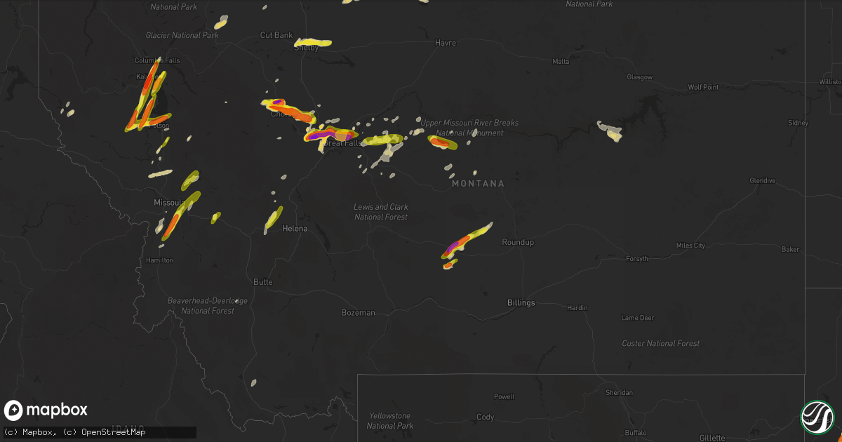
Hail Map in Montana on July 7, 2022
Get this storm
July 7 map
$229
one time, instant access
Download today. No call, no setup
Keep the $229
Bought the map and want the full workflow? Apply the entire $229 to a subscription within 7 days. None of it is wasted.
Every map, not just this one
This buys you this map. Subscription and you get every map we run, in the markets you choose from a few cities to whole states to nationwide. Plus real-time alerts the moment a storm fires.
Contact data
Name, contact info, occupancy, even credit band for addresses in the footprint. You go from where it hit to who to call.
Become the source they trust
Unlimited branding weather history reports on demand. You already have the documented answer ready for the property owner, and you are the one who showed up with it.
Property data and RoofTrace estimates
Pull up any address you have got, its value and the exact code rules for that jurisdiction, straight from One Click Code. Then RoofTrace estimates the squares, pitch, and roof value, priced the way you price.
Storm reports in Montana
Montana
| Date | Description |
|---|---|
| 07/07/20226:50 PM CDT | Pictures submitted of large hail in black eagle. |
| 07/07/20226:49 PM CDT | Photos submitted of nearly 2 inch hail. |
| 07/07/20226:48 PM CDT | Photos submitted of large hail in nw great falls. |
| 07/07/20226:48 PM CDT | Updated report to increase hail size based on new photos. Previous report. Several photos from members of public of 2 inch hail in the riverview area. |
| 07/07/20226:48 PM CDT | Several photos from members of public of 2 inch hail in the riverview area. |
| 07/07/20226:45 PM CDT | Hail estimated via photo. |
| 07/07/20226:45 PM CDT | A local report indicates 1.75 inch wind near 1 N BLACK EAGLE |
| 07/07/20226:26 PM CDT | Report from mping: hen egg |
| 07/07/20226:24 PM CDT | A local report indicates 2.00 inch wind near 3 NE SUN PRAIRIE |
| 07/07/20226:18 PM CDT | A local report indicates 1.00 inch wind near 15 ENE MELVILLE |
| 07/07/20226:06 PM CDT | Storm chaser submitted photos of very large hail along interstate 15. Largest stone measured was 2.25 inches. Traffic on interstate 15 was brought to a halt. Hail laste |
| 07/07/20226:06 PM CDT | Report from mping: quarter |
| 07/07/20226:05 PM CDT | Corrects previous hail report from 3 nnw vaughn. |
| 07/07/20226:05 PM CDT | A local report indicates 1.50 inch wind near 3 NNW VAUGHN |
| 07/07/20225:42 PM CDT | Corrects previous hail time of report from 3 nw sun river. Report from mping: hen egg |
| 07/07/20225:38 PM CDT | Time of occurrence estimated from radar. |
| 07/07/20225:32 PM CDT | Spotter reported 3.25 inch hail near sun river. Photos from the area submitted by general public appear to verify this report. |
| 07/07/20225:30 PM CDT | Near welker farms... Just ne of shelby. Golf ball-sized hail. Damaged crops. |
| 07/07/20225:25 PM CDT | A local report indicates 1.00 inch wind near 3 NW SUN RIVER |
| 07/07/20225:11 PM CDT | Largest hailstone was 1 inch... Most were nickel-sized. |
| 07/07/20224:59 PM CDT | Report from mping: ping pong ball |
| 07/07/20224:56 PM CDT | Reported half inch to three-quarters inch hail... Some slightly larger. |
| 07/07/20224:48 PM CDT | Report from mping: golf ball |
| 07/07/20224:45 PM CDT | Hail stones were bouncing several feet off of the ground. |
| 07/07/20224:42 PM CDT | Location and time estimated. |
| 07/07/20224:18 PM CDT | Began with golf ball size hail... But has increased to baseballs. |
| 07/07/20224:15 PM CDT | Report from mping: golf ball |
| 07/07/20224:12 PM CDT | Report from mping: ping pong ball |
| 07/07/20223:24 PM CDT | Measured at lj johnson farms via ambient weather. Temp dropped from 75 degrees to 55 degrees with passage of storm. |
| 07/07/20224:35 AM CDT | At 935 PM MDT, a severe thunderstorm was located near Columbia Falls, or near Evergreen, moving north at 25 mph. HAZARD...Golf ball size hail and 60 mph wind gusts. SOURCE...Radar indicated. IMPACT...People and animals outdoors will be injured. Expect hail damage to roofs, siding, windows, and vehicles. Expect wind damage to roofs, siding, and trees. Locations impacted include... Kalispell, Evergreen, Columbia Falls, West Glacier, Apgar, Martin City, Coram, Hungry Horse and La Salle. |
| 07/07/20224:25 AM CDT | At 925 PM MDT, a severe thunderstorm was located near Big Arm, or 11 miles northwest of Polson, moving northeast at 25 mph. HAZARD...Golf ball size hail and 60 mph wind gusts. SOURCE...Radar indicated. IMPACT...People and animals outdoors will be injured. Expect hail damage to roofs, siding, windows, and vehicles. Expect wind damage to roofs, siding, and trees. Locations impacted include... Big Arm, Proctor, Lakeside, Lake Mary Ronan, Elmo, Rollins and Dayton. |
| 07/07/20224:12 AM CDT | At 912 PM MDT, a severe thunderstorm was located over Kalispell, moving north at 25 mph. HAZARD...Ping pong ball size hail and 60 mph wind gusts. SOURCE...Radar indicated. IMPACT...People and animals outdoors will be injured. Expect hail damage to roofs, siding, windows, and vehicles. Expect wind damage to roofs, siding, and trees. Locations impacted include... Kalispell, Evergreen, Whitefish, Columbia Falls, La Salle and Somers. |
| 07/07/20224:09 AM CDT | At 908 PM MDT, severe thunderstorms were located along a line extending from 10 miles north of Belt to near Highwood to 16 miles west of Geraldine to near Geyser, moving northeast at 30 mph. HAZARD...Quarter size hail. SOURCE...Radar indicated. IMPACT...Damage to vehicles is expected. Locations impacted include... Fort Benton, Geraldine, Highwood, Geyser, Shonkin and Square Butte. |
| 07/07/20224:02 AM CDT | At 902 PM MDT, a severe thunderstorm was located 11 miles southwest of Big Arm, or 13 miles west of Polson, moving northeast at 25 mph. HAZARD...Golf ball size hail and 60 mph wind gusts. SOURCE...Radar indicated. IMPACT...People and animals outdoors will be injured. Expect hail damage to roofs, siding, windows, and vehicles. Expect wind damage to roofs, siding, and trees. Locations impacted include... Big Arm and Elmo. |
| 07/07/20223:51 AM CDT | At 851 PM MDT, a severe thunderstorm was located 12 miles south of Kalispell, moving north at 25 mph. HAZARD...60 mph wind gusts and quarter size hail. SOURCE...Radar indicated. IMPACT...Hail damage to vehicles is expected. Expect wind damage to roofs, siding, and trees. Locations impacted include... Kalispell, Evergreen, Kila and Somers. |
| 07/07/20223:49 AM CDT | At 848 PM MDT, severe thunderstorms were located along a line extending from 12 miles east of Black Eagle to near Belt to 10 miles west of Geyser, moving northeast at 20 mph. HAZARD...Quarter size hail. SOURCE...Radar indicated. IMPACT...Damage to vehicles is expected. Locations impacted include... Belt, Highwood, Raynesford and Armington. |
| 07/07/20223:40 AM CDT | At 839 PM MDT, a severe thunderstorm was located near Fort Shaw, or 22 miles southeast of Choteau, moving northeast at 20 mph. HAZARD...Quarter size hail. SOURCE...Radar indicated. IMPACT...Damage to vehicles is expected. Locations impacted include... Power. |
| 07/07/20223:33 AM CDT | At 832 PM MDT, a severe thunderstorm was located 9 miles west of Seeley Lake, or 24 miles northeast of Missoula, moving northeast at 25 mph. HAZARD...60 mph wind gusts and quarter size hail. SOURCE...Radar indicated. IMPACT...Hail damage to vehicles is expected. Expect wind damage to roofs, siding, and trees. Locations impacted include... Seeley Lake. |
| 07/07/20223:24 AM CDT | At 823 PM MDT, severe thunderstorms were located along a line extending from 17 miles southeast of Belt to 8 miles south of Geyser to near Stanford, moving northeast at 20 mph. HAZARD...Quarter size hail. SOURCE...Radar indicated. IMPACT...Damage to vehicles is expected. Locations impacted include... Stanford, Denton, Geyser and Coffee Creek. |
| 07/07/20223:17 AM CDT | At 816 PM MDT, a severe thunderstorm was located 9 miles east of Fort Shaw, or 14 miles west of Great Falls, moving northeast at 30 mph. HAZARD...Half dollar size hail. SOURCE...Radar indicated. IMPACT...Damage to vehicles is expected. Locations impacted include... Vaughn and First Peoples Buffalo Jump State Park. |
| 07/07/20223:13 AM CDT | At 812 PM MDT, a severe thunderstorm was located 14 miles north of Denton, or 30 miles northeast of Stanford, moving east at 15 mph. HAZARD...60 mph wind gusts and half dollar size hail. SOURCE...Radar indicated. IMPACT...Hail damage to vehicles is expected. Expect wind damage to roofs, siding, and trees. Locations impacted include... Winifred and Iliad. |
| 07/07/20223:07 AM CDT | At 807 PM MDT, a severe thunderstorm was located near Big Arm, or 8 miles west of Polson, moving east at 30 mph. HAZARD...Golf ball size hail and 60 mph wind gusts. SOURCE...Radar indicated. IMPACT...People and animals outdoors will be injured. Expect hail damage to roofs, siding, windows, and vehicles. Expect wind damage to roofs, siding, and trees. Locations impacted include... Polson, Rocky Point, Jette, Kerr, Kings Point, Big Arm and Finley Point. |
| 07/07/20222:56 AM CDT | At 756 PM MDT, a severe thunderstorm was located 14 miles west of Big Arm, or 19 miles west of Polson, moving northeast at 20 mph. HAZARD...Golf ball size hail and 60 mph wind gusts. SOURCE...Radar indicated. IMPACT...People and animals outdoors will be injured. Expect hail damage to roofs, siding, windows, and vehicles. Expect wind damage to roofs, siding, and trees. Locations impacted include... Niarada and Lonepine. |
| 07/07/20222:55 AM CDT | At 755 PM MDT, a severe thunderstorm was located 7 miles southwest of Bigfork, or 12 miles south of Kalispell, moving northeast at 20 mph. HAZARD...Ping pong ball size hail and 60 mph wind gusts. SOURCE...Radar indicated. IMPACT...People and animals outdoors will be injured. Expect hail damage to roofs, siding, windows, and vehicles. Expect wind damage to roofs, siding, and trees. Locations impacted include... Bigfork, Woods Bay, Creston, Somers and Lakeside. |
| 07/07/20222:50 AM CDT | A local report indicates 1.00 inch wind near CHARLO |
| 07/07/20222:48 AM CDT | At 748 PM MDT, severe thunderstorms were located along a line extending from 19 miles south of Winifred to 15 miles northwest of Lewistown to 11 miles southeast of Denton, moving northeast at 25 mph. HAZARD...Quarter size hail. SOURCE...Radar indicated. IMPACT...Damage to vehicles is expected. Locations impacted include... Danvers, Hilger and Christina. |
| 07/07/20222:41 AM CDT | At 741 PM MDT, a severe thunderstorm was located 16 miles northeast of Plains, or 23 miles west of Polson, moving northeast at 15 mph. HAZARD...Golf ball size hail and 60 mph wind gusts. SOURCE...Radar indicated. IMPACT...People and animals outdoors will be injured. Expect hail damage to roofs, siding, windows, and vehicles. Expect wind damage to roofs, siding, and trees. Locations impacted include... Hot Springs, Camas and Lonepine. |
| 07/07/20222:16 AM CDT | At 715 PM MDT, a severe thunderstorm was located 8 miles east of Florence, or 17 miles south of Missoula, moving northeast at 30 mph. HAZARD...Two inch hail and 70 mph wind gusts. SOURCE...Radar indicated. IMPACT...People and animals outdoors will be injured. Expect hail damage to roofs, siding, windows, and vehicles. Expect considerable tree damage. Wind damage is also likely to mobile homes, roofs, and outbuildings. Locations impacted include... Bonner-West Riverside, Clinton and Turah. |
| 07/07/20222:08 AM CDT | At 708 PM MDT, severe thunderstorms were located along a line extending from 8 miles northeast of Fort Benton to near Geraldine, moving east at 35 mph. HAZARD...60 mph wind gusts and quarter size hail. SOURCE...Radar indicated. IMPACT...Hail damage to vehicles is expected. Expect wind damage to roofs, siding, and trees.These storms have a history of producing funnel clouds. Locations impacted include... Fort Benton, Geraldine, St. Pierre, Parker School, Loma, Square Butte, Judith Landing, Iliad and Virgelle. |
| 07/07/20222:01 AM CDT | At 701 PM MDT, a severe thunderstorm was located near Drummond, moving east at 15 mph. HAZARD...60 mph wind gusts and half dollar size hail. SOURCE...Radar indicated. IMPACT...Hail damage to vehicles is expected. Expect wind damage to roofs, siding, and trees. Locations impacted include... Drummond, New Chicago and Bearmouth. |
| 07/07/20221:57 AM CDT | At 656 PM MDT, a severe thunderstorm was located over Stevensville, or 20 miles north of Hamilton, moving northeast at 20 mph. HAZARD...Ping pong ball size hail and 60 mph wind gusts. SOURCE...Radar indicated. IMPACT...People and animals outdoors will be injured. Expect hail damage to roofs, siding, windows, and vehicles. Expect wind damage to roofs, siding, and trees. Locations impacted include... Stevensville, Florence and Bell Crossing. |
| 07/07/20221:30 AM CDT | At 629 PM MDT, a severe thunderstorm was located 33 miles north of Beaver Creek, or 35 miles northwest of Havre, moving southeast at 30 mph. HAZARD...Golf ball size hail. SOURCE...Radar indicated. IMPACT...People and animals outdoors will be injured. Expect damage to roofs, siding, windows, and vehicles. This severe thunderstorm will remain over mainly rural areas of northwestern Blaine and northeastern Hill Counties. |
| 07/07/20221:25 AM CDT | At 624 PM MDT, a severe thunderstorm was located 18 miles northwest of Helena, moving northeast at 20 mph. HAZARD...60 mph wind gusts and half dollar size hail. SOURCE...Radar indicated. IMPACT...Hail damage to vehicles is expected. Expect wind damage to roofs, siding, and trees. Locations impacted include... Wolf Creek, Marysville, Canyon Creek, Black Sandy State Park, Austin and Spring Meadow Lake State Park. |
| 07/07/20221:22 AM CDT | At 622 PM MDT, severe thunderstorms were located along a line extending from 15 miles southwest of Fort Benton to near Highwood to 16 miles northeast of Belt, moving east at 30 mph. HAZARD...70 mph wind gusts and quarter size hail. SOURCE...Radar indicated. IMPACT...Hail damage to vehicles is expected. Expect considerable tree damage. Wind damage is also likely to mobile homes, roofs, and outbuildings.These storms have a history of producing 2 inch diameter hail and funnel clouds. Locations impacted include... Fort Benton, Geraldine, Highwood, Carter, Shonkin, Floweree, Loma and Square Butte. |
| 07/07/202212:58 AM CDT | At 558 PM MDT, a severe thunderstorm was located 13 miles northeast of Deadmans Basin Reservoir, or 27 miles east of Harlowton, moving northeast at 30 mph. HAZARD...Ping pong ball size hail and 60 mph wind gusts. SOURCE...Radar indicated. IMPACT...People and animals outdoors will be injured. Expect hail damage to roofs, siding, windows, and vehicles. Expect wind damage to roofs, siding, and trees. This severe thunderstorm will remain over mainly rural areas of northwestern Musselshell and northeastern Golden Valley Counties.This replaces the warning previously in effect for this area. |
| 07/07/202212:55 AM CDT | At 555 PM MDT, a severe thunderstorm was located 16 miles east of Garrison, or 17 miles northeast of Deer Lodge, moving northeast at 15 mph. HAZARD...Quarter size hail. SOURCE...Radar indicated. IMPACT...Damage to vehicles is expected. Locations impacted include... Elliston. |
| 07/07/202212:35 AM CDT | At 534 PM MDT, severe thunderstorms were located along a line extending from 6 miles northeast of Power to near Black Eagle to near Belt, moving east at 25 mph. HAZARD...60 mph wind gusts and half dollar size hail. SOURCE...Radar indicated. IMPACT...Hail damage to vehicles is expected. Expect wind damage to roofs, siding, and trees. Locations impacted include... Great Falls, Fort Benton, Belt, Geraldine, Black Eagle, Highwood, Carter, Floweree, Portage, Malmstrom Afb, Tracy, Centerville, Shonkin and Sand Coulee.Funnel clouds have been observed north of Great Falls. |
| 07/07/202212:05 AM CDT | At 505 PM MDT, a severe thunderstorm was located 12 miles southwest of Deadmans Basin Reservoir, or 22 miles southeast of Harlowton, moving east at 10 mph. HAZARD...60 mph wind gusts and quarter size hail. SOURCE...Radar indicated. IMPACT...Hail damage to vehicles is expected. Expect wind damage to roofs, siding, and trees. Locations impacted include... Ryegate, Deadmans Basin Reservoir, Franklin and Shawmut. |
| 07/06/202211:51 PM CDT | At 451 PM MDT, severe thunderstorms were located along a line extending from Dutton to near Power to 11 miles northeast of Fort Shaw, moving east northeast at 25 mph. HAZARD...60 mph wind gusts and quarter size hail. SOURCE...Radar indicated. IMPACT...Hail damage to vehicles is expected. Expect wind damage to roofs, siding, and trees. Locations impacted include... Great Falls, Dutton, The Knees, Black Eagle, Power, Carter, Floweree, Portage, Vaughn, First Peoples Buffalo Jump State Park and Malmstrom Afb. |
| 07/06/202211:39 PM CDT | At 438 PM MDT, a severe thunderstorm was located 13 miles east of Shelby, moving east at 15 mph. HAZARD...60 mph wind gusts and quarter size hail. SOURCE...Radar indicated. IMPACT...Hail damage to vehicles is expected. Expect wind damage to roofs, siding, and trees. Locations impacted include... Devon, Galata and Dunkirk. |
| 07/06/202211:09 PM CDT | At 409 PM MDT, severe thunderstorms were located along a line extending from 10 miles east of Choteau to near Fairfield to near Fort Shaw, moving east northeast at 20 mph. HAZARD...60 mph wind gusts and half dollar size hail. SOURCE...Radar indicated. IMPACT...Hail damage to vehicles is expected. Expect wind damage to roofs, siding, and trees. Locations impacted include... Fairfield, Dutton, Fort Shaw, Fort Shaw, Power, Ulm, Vaughn, First Peoples Buffalo Jump State Park, Simms and Sun River. |
| 07/06/202210:56 PM CDT | At 356 PM MDT, a severe thunderstorm was located over Choteau, moving east at 10 mph. HAZARD...60 mph wind gusts and half dollar size hail. SOURCE...Radar indicated. IMPACT...Hail damage to vehicles is expected. Expect wind damage to roofs, siding, and trees. Locations impacted include... Choteau, Farmington and Collins. |
| 07/06/202210:48 PM CDT | Facebook report. Hail ranged from pea sized up to 1.25 inch in diameter. Also reported a lightning strike to their barn. |
| 07/06/202210:46 PM CDT | At 346 PM MDT, a severe thunderstorm was located near Shelby, moving northeast at 10 mph. HAZARD...60 mph wind gusts and half dollar size hail. SOURCE...Radar indicated. IMPACT...Hail damage to vehicles is expected. Expect wind damage to roofs, siding, and trees. Locations impacted include... Shelby, Kevin, Ferdig, Ethridge and Oilmont. |
| 07/06/202210:45 PM CDT | A local report indicates 1.00 inch wind near COLUMBIA FALLS |
| 07/06/202210:36 PM CDT | Hail size ranged between ping pongs and golf balls. |
| 07/06/202210:32 PM CDT | A local report indicates 1.50 inch wind near 2 ESE ELMO |
| 07/06/202210:21 PM CDT | At 320 PM MDT, a severe thunderstorm was located 7 miles north of Choteau, moving east at 15 mph. THIS IS A DESTRUCTIVE STORM FOR Baseball Size hail. HAZARD...Baseball size hail and 60 mph wind gusts. SOURCE...Trained weather spotters. IMPACT...People and animals outdoors will be severely injured. Expect shattered windows, extensive damage to roofs, siding, and vehicles. Locations impacted include... Choteau, Brady, Collins, Farmington and Bynum. |
| 07/06/202210:20 PM CDT | A local report indicates 1.75 inch wind near EVERGREEN |
| 07/06/202210:20 PM CDT | A local report indicates 1.75 inch wind near 1 S KALISPELL |
| 07/06/202210:18 PM CDT | Reports numerous broken windshields. |
| 07/06/202210:18 PM CDT | Facebook report from evergreen area. 40-50 mph winds and heavy rain accompanied the hail... Which ranged between golf ball and lime sized. |
| 07/06/202210:12 PM CDT | Reports damage to cars in the neighborhood. |
| 07/06/202210:08 PM CDT | A local report indicates 1.75 inch wind near 2 S KALISPELL |
| 07/06/20229:54 PM CDT | A local report indicates 1.00 inch wind near SEELEY LAKE |
| 07/06/20229:38 PM CDT | At 237 PM MDT, a severe thunderstorm was located 17 miles northwest of Choteau, moving east at 10 mph. HAZARD...Quarter size hail. SOURCE...Radar indicated. IMPACT...Damage to vehicles is expected. Locations impacted include... Pendroy and Bynum. |
| 07/06/20229:35 PM CDT | Large quantity of nickel size hail that caused significant damage to a greenhouse business. Strong winds broke decent size tree branches... But unable to estimate wind |
| 07/06/20229:18 PM CDT | A local report indicates 1.00 inch wind near 3 SSE CRESTON |
| 07/06/20229:05 PM CDT | A local report indicates 1.00 inch wind near SOMERS |
| 07/06/20228:50 PM CDT | A local report indicates 1.25 inch wind near 2 SSE LONEPINE |
| 07/06/20228:29 PM CDT | Received a call about a fallen tree and a barn roof ripped off. The caller stated that he either had a very localized microburst or a tornado. The damage was very local |
| 07/06/20228:27 PM CDT | At 127 PM MDT, a severe thunderstorm was located 15 miles northwest of North Browning, moving northeast at 20 mph. HAZARD...Quarter size hail. SOURCE...Radar indicated. IMPACT...Damage to vehicles is expected. This severe thunderstorm will remain over mainly rural areas of northeastern Glacier County. |
| 07/06/20228:25 PM CDT | A local report indicates 1.00 inch wind near 4 E FLORENCE |
| 07/06/20228:20 PM CDT | Strong winds causing power outage and a broken cottonwood tree. |
| 07/06/20228:15 PM CDT | Sent in by twitter. |
| 07/06/20228:15 PM CDT | Picture sent in by twitter. |
| 07/06/20228:06 PM CDT | A local report indicates 1.50 inch wind near 3 SSE FLORENCE |
| 07/06/20227:02 PM CDT | Report from mping: quarter |
All States Impacted by Hail Map on July 7, 2022
Cities Impacted by Hail Map on July 7, 2022
- Shelby, MT
- Somers, MT
- Lakeside, MT
- Kalispell, MT
- Highwood, MT
- Floweree, MT
- Fort Benton, MT
- Upton, WY
- Choteau, MT
- Howes, SD
- Trout Creek, MT
- Almont, ND
- Glen Ullin, ND
- Grover, CO
- Carpenter, WY
- Mud Butte, SD
- Columbia Falls, MT
- Fairfield, MT
- Ten Sleep, WY
- Raynesford, MT
- Geyser, MT
- Meeteetse, WY
- Cody, WY
- Geraldine, MT
- Canyon Creek, MT
- Wise River, MT
- Charlo, MT
- Arlee, MT
- Havre, MT
- Winifred, MT
- Valier, MT
- Union Center, SD
- Dupree, SD
- Faith, SD
- Elliston, MT
- Avon, MT
- Marysville, MT
- Condon, MT
- Belt, MT
- Great Falls, MT
- Reva, SD
- Buffalo, SD
- Newell, SD
- Sunburst, MT
- Whitlash, MT
- Sheridan, WY
- Elgin, ND
- Elmo, MT
- Kila, MT
- Dayton, MT
- Proctor, MT
- Lonepine, MT
- Hot Springs, MT
- Polson, MT
- Big Arm, MT
- Rollins, MT
- White Plains, KY
- Dutton, MT
- Chugwater, WY
- Wheatland, WY
- Cut Bank, MT
- Hilger, MT
- Lewistown, MT
- Browning, MT
- Lincoln, MT
- Enning, SD
- Denton, MT
- Kaycee, WY
- Corvallis, MT
- Stevensville, MT
- Victor, MT
- Missoula, MT
- Mobridge, SD
- Ralph, SD
- Sturgis, SD
- Nemo, SD
- Piedmont, SD
- Wolf Creek, MT
- Tower Hill, IL
- Harrison, NE
- Bynum, MT
- Vaughn, MT
- Power, MT
- Black Eagle, MT
- Sun River, MT
- Fort Shaw, MT
- Elizabethtown, IL
- Herod, IL
- Wakpala, SD
- Bendena, KS
- Troy, KS
- Robinson, KS
- Highland, KS
- Denton, KS
- Jordan, MT
- Fort Peck, MT
- Buffalo Gap, SD
- Jay Em, WY
- Auburn, NE
- Johnson, NE
- Brock, NE
- Gillette, WY
- Chadron, NE
- Whitney, NE
- Clinton, MT
- Florence, MT
- Charleston, MO
- Hendersonville, TN
- Gallatin, TN
- Bonner, MT
- Torrington, WY
- Morrill, NE
- Dawson, NE
- Dalton, NE
- Broadwater, NE
- Merino, CO
- Wright, WY
- Dillon, MT
- Thompson Falls, MT
- Vale, SD
- Snyder, CO
- Hermosa, SD
- Keystone, SD
- Custer, SD
- Hill City, SD
- Rush, CO
- Ordway, CO
- Shawmut, MT
- Melville, MT
- Perryville, KY
- Parksville, KY
- Gravel Switch, KY
- Springfield, KY
- Danville, KY
- Oregon, MO
- Forest City, MO
- Rockham, SD
- Faulkton, SD
- Drummond, MT
- Lexington, TN
- Merriman, NE
- Hugo, CO
- Brunswick, GA
- Kim, CO
- Mcminnville, TN
- Morrison, TN
- Woodbury, TN
- Flowery Branch, GA
- Chattanooga, TN
- Bethpage, TN
- Roebuck, SC
- Pauline, SC
- Model, CO
- Trilla, IL
- Neoga, IL
- Spartanburg, SC
- Cookeville, TN
- Gallant, AL
- Altoona, AL
- Oneonta, AL
- Darden, TN
- Parsons, TN
- Buford, GA
- Suwanee, GA
- Cumming, GA
- Spring Lake, NC
- Fort Bragg, NC
- Pope Army Airfield, NC
- Eatonton, GA
- Watertown, TN
- Brush Creek, TN
- Brentwood, TN
- Raleigh, NC
- Menlo, GA
- Rising Fawn, GA
- Smithville, TN
- Sparta, TN
- Holland, KY
- Scottsville, KY
- Maryville, TN
- Longdale, OK
- Seiling, OK
- Signal Mountain, TN
- Madison, GA
- Newborn, GA
- Ryegate, MT
- Bayard, NE
- Rye, CO
- Colorado City, CO
- Pueblo, CO
- Greenville, KY
- Limon, CO
- Glenallen, MO
- Marble Hill, MO
- Patton, MO
- Rock Island, TN
- Ellington, MO
- Tompkinsville, KY
- Portland, TN
- Seeley Lake, MT
- Dixon, MT
- Whitewater, MO
- Crofton, KY
- Sedan, NM
- Scottsboro, AL
- Woodville, AL
- Hollytree, AL
- Keystone Heights, FL
- Melrose, FL
- Goodlettsville, TN
- White House, TN
- Joelton, TN
- Westmoreland, TN
- Greenbrier, TN
- Cottontown, TN
- Louisville, GA
- Madison, TN
- Old Hickory, TN
- Laceys Spring, AL
- Lead, SD
- Harrisonville, MO
- Lavina, MT
- Edinburg, IL
- Pawnee, IL
- Rochester, IL
- Pritchett, CO
- Las Animas, CO
- Colorado Springs, CO
- Penrose, CO
- Florissant, CO
- Harrisburg, NE
- Gamaliel, KY
- Fountain Run, KY
- Edmonton, KY
- Burkesville, KY
- Greenville, MO
- Marquand, MO
- Easley, SC
- Pickens, SC
- Marietta, SC
- Jansen, NE
- Fairbury, NE
- Summerville, GA
- Gainesville, GA
- Milledgeville, GA
- Thompsons Station, TN
- Franklin, TN
- Fairview, OK
- Tulia, TX
- Monticello, GA
- Mansfield, GA
- Shelbyville, TN
- Bell Buckle, TN
- Enoree, SC
- Gray Court, SC
- Woodruff, SC
- Auburn, KY
- Braselton, GA
- Lebanon, TN
- Ronan, MT
- Hazlehurst, GA
- Currie, NC
- Pleasant Shade, TN
- Walland, TN
- Garnett, KS
- Norris City, IL
- Midway, GA
- Fort Myers, FL
- Pine Bluffs, WY
- Bushnell, NE
- Maitland, MO
- Fillmore, MO
- Reynolds, NE
- Punta Gorda, FL
- Paint Rock, AL
- Gainesboro, TN
- Carthage, TN
- Elmwood, TN
- Poplar Bluff, MO
- Steele, AL
- Rainbow City, AL
- Ashville, AL
- Manchester, TN
- Nancy, KY
- Russell Springs, KY
- Haddock, GA
- Gray, GA
- Helena, MO
- Savannah, MO
- Redfield, SD
- Dimmitt, TX
- Amity, MO
- Rea, MO
- Union Star, MO
- Rosendale, MO
- Cosby, MO
- Maysville, MO
- Springfield, CO
- Branson, CO
- Lyons, CO
- Wray, CO
- Hunnewell, MO
- Emden, MO
- Selma, NC
- Kenly, NC
- Granville, TN
- Buffalo Valley, TN
- Chestnut Mound, TN
- Riddleton, TN
- Campo, CO
- Bowling Green, KY
- Alvaton, KY
- College Grove, TN
- Spring Hill, TN
- Camden, IL
- Littleton, IL
- Plymouth, IL
- Cheyenne, WY
- Haleyville, AL
- Rushville, IL
- Huntsville, IL
- Primm Springs, TN
- Beulah, CO
- Sylvester, GA
- Poulan, GA
- Amsterdam, MO
- Parker, KS
- Centerville, KS
- Kit Carson, CO
- Fort Morgan, CO
- Clayton, NC
- Gurley, AL
- Trenton, AL
- Chaffee, MO
- Owens Cross Roads, AL
- Walsh, CO
- Somerville, AL
- Bethany, IL
- Hestand, KY
- Moss, TN
- Bardwell, KY
- Arlington, KY
- Ellabell, GA
- Silver Point, TN
- Rockledge, GA
- Townsend, GA
- Walsenburg, CO
- Central City, KY
- Drakesboro, KY
- Mahaska, KS
- Hubbell, NE
- Liberty, TN
- Plains, GA
- Fayetteville, TN
- Mulberry, TN
- Flintville, TN
- Genoa, CO
- Manville, WY
- Osawatomie, KS
- Beechmont, KY
- Beech Creek, KY
- Belton, KY
- Powderly, KY
- Browder, KY
- Graham, KY
- Dunlap, TN
- Adamsville, TN
- Maysville, GA
- Morganfield, KY
- Uniontown, KY
- Glendo, WY
- Hortense, GA
- Georgetown, FL
- Crescent City, FL
- Dixon, KY
- Slaughters, KY
- Florence, AL
- Muscle Shoals, AL
- Riceboro, GA
- Whitwell, TN
- Central, SC
- Pendleton, SC
- Saint Ignatius, MT
- Rocky Point, NC
- Castlewood, SD
- Pine Ridge, SD
- Newcastle, WY
- Huntsville, AL
- Essex, MO
- Dexter, MO
- Bethel Springs, TN
- Crawford, TN
- Lane, KS
- Rantoul, KS
- Richmond, KS
- Odenville, AL
- Cave In Rock, IL
- Cleveland, SC
- Lula, GA
- Sequatchie, TN
- Hot Springs, SD
- Washington, KS
- Hanover, KS
- Hollenberg, KS
- Minatare, NE
- Millersville, MO
- Cook, NE
- Princeton, KS
- Parkton, NC
- Lumber Bridge, NC
- Nicholls, GA
- Clarence, MO
- Lentner, MO
- Shelbina, MO
- Cape Girardeau, MO
- Science Hill, KY
- Windsor, KY
- Archie, MO
- Drexel, MO
- Freeman, MO
- Louisburg, KS
- Paola, KS
- Mount Vernon, IN
- Nortonville, KY
- Bridgeport, NE
- Brownsboro, AL
- Oneida, TN
- Lodgepole, NE
- Harrisburg, IL
- Spring City, TN
- Hereford, TX
- Hampstead, NC
- Cartersville, GA
- Russellville, KY
- Adairville, KY
- Franklin, KY
- East Prairie, MO
- Stearns, KY
- Grandview, TN
- Kelso, TN
- Jacksonville, FL
- Yulee, FL
- White Owl, SD
- Prairie City, SD
- Fort Meade, SD
- Casper, WY
- Bigfork, MT
- White Bird, ID
- Grangeville, ID
- Sugar City, CO
- Bowdle, SD
- Roscoe, SD
- Ipswich, SD
- Tulare, SD
- Kyle, SD
- Manderson, SD
- Wall, SD
- Oglala, SD
- Wounded Knee, SD
- Batesland, SD
- Rushville, NE
- Saint Joseph, MO
- Elwood, KS
- Wathena, KS
- Amazonia, MO
- Clarksdale, MO
- King City, MO


