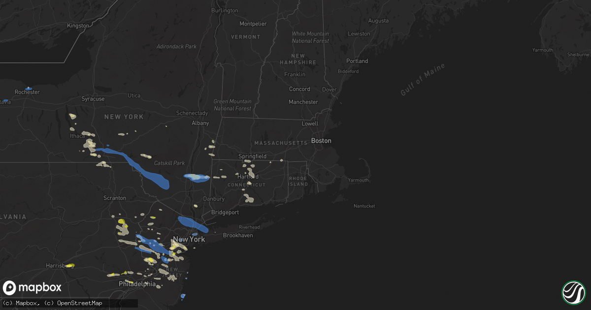
Hail Map in Connecticut on July 6, 2021
Get this storm
July 6 map
$229
one time, instant access
Download today. No call, no setup
Keep the $229
Bought the map and want the full workflow? Apply the entire $229 to a subscription within 7 days. None of it is wasted.
Every map, not just this one
This buys you this map. Subscription and you get every map we run, in the markets you choose from a few cities to whole states to nationwide. Plus real-time alerts the moment a storm fires.
Contact data
Name, contact info, occupancy, even credit band for addresses in the footprint. You go from where it hit to who to call.
Become the source they trust
Unlimited branding weather history reports on demand. You already have the documented answer ready for the property owner, and you are the one who showed up with it.
Property data and RoofTrace estimates
Pull up any address you have got, its value and the exact code rules for that jurisdiction, straight from One Click Code. Then RoofTrace estimates the squares, pitch, and roof value, priced the way you price.
Storm reports in Connecticut
Connecticut
| Date | Description |
|---|---|
| 07/06/20214:45 PM CDT | Police report trees and power lines down. |
| 07/06/20214:40 PM CDT | Police report several trees down around the town. |
| 07/06/20214:22 PM CDT | Tree and wires down on standish road |
| 07/06/20214:15 PM CDT | Trees and wires down on farmington ave at everett... And on mountain road |
| 07/06/20214:06 PM CDT | Trees down on wires with two cars trapped by live wires at middle road turnpike and cat swamp road |
| 07/06/20214:01 PM CDT | Tree down on house on taylor road |
| 07/06/20214:00 PM CDT | Power lines downed on north street. |
| 07/06/20213:57 PM CDT | Numerous trees and wires down |
| 07/06/20213:57 PM CDT | Tree down onto house on bell ave |
| 07/06/20213:52 PM CDT | Several trees down. Time estimated by radar. |
| 07/06/20213:50 PM CDT | Trees down on warertown road |
| 07/06/20213:47 PM CDT | Several trees down. Time estimated by radar. |
| 07/06/20213:46 PM CDT | Tree down on powerlines |
| 07/06/20213:38 PM CDT | Several trees down. Time estimated by radar. |
| 07/06/20213:30 PM CDT | Power lines downed on segar mountain road |
| 07/06/20213:28 PM CDT | Route 7 northbound and route 341 eastbound are closed due to trees down. |
| 07/06/20213:28 PM CDT | Multiple trees downed in macedonia section of kent |
| 07/06/20213:28 PM CDT | Several trees down. Time estimated by radar. |
| 07/06/20211:28 AM CDT | At 626 PM EDT, severe thunderstorms were located along a line extending from near Dobbs Ferry to Flushing to Huguenot, moving southeast at 60 mph. HAZARD...70 mph wind gusts. SOURCE...Radar indicated. IMPACT...Expect damage to trees and power lines. Severe thunderstorms will be near... Jamaica and New Rochelle around 630 PM EDT. Valley Stream and Port Chester around 635 PM EDT. Long Beach and Glen Cove around 640 PM EDT. Levittown and Freeport around 645 PM EDT. Plainview and Massapequa around 650 PM EDT. Huntington Station and Lindenhurst around 655 PM EDT. Brentwood and Commack around 700 PM EDT. Islip and Hauppauge around 705 PM EDT. Centereach and Ronkonkoma around 710 PM EDT. |
| 07/06/202112:53 AM CDT | At 549 PM EDT, severe thunderstorms were located along a line extending from near Vernon Valley to near Lake Telemark to near Chester, moving east at 55 mph. HAZARD...70 mph wind gusts. SOURCE...Radar indicated. IMPACT...Expect considerable tree damage. Damage is likely to mobile homes, outbuildings. Severe thunderstorms will be near... Bloomingdale around 555 PM EDT. Wayne, Ringwood, Pompton Lakes, Fairfield and Greenwood Lake around 600 PM EDT. Sloatsburg and Hawthorne around 605 PM EDT. Paterson, Paramus, Summit, and Caldwell around 610 PM EDT. Bloomfield and Hackensack around 615 PM EDT. Newark, Ridgefield, Harlem and Riverdale around 620 PM EDT. Jersey City, Yonkers, Bayonne, and Secaucus around 625 PM EDT. Flatbush, Flushing, Hoboken, Coney Island, Crown Heights, the Throgs Neck Bridge and Midtown Manhattan around 630 PM EDT. |
| 07/06/202112:52 AM CDT | At 552 PM EDT, severe thunderstorms were located along a line extending from near Holliston to Willimantic, moving southeast at 25 mph. HAZARD...60 mph wind gusts and penny size hail. SOURCE...Radar indicated. IMPACT...Expect damage to trees and power lines. Locations impacted include... Providence, Fall River, Warwick, Cranston, Pawtucket, Taunton, East Providence, Woonsocket, Coventry, Cumberland, North Providence, Franklin, South Kingstown, West Warwick, Johnston, North Attleborough, Milford, North Kingstown, Windham and Bristol. |
| 07/06/202112:35 AM CDT | At 534 PM EDT, a severe thunderstorm was located near Glastonbury, moving east at 35 mph. HAZARD...60 mph wind gusts and penny size hail. SOURCE...Radar indicated. IMPACT...Expect damage to trees and power lines. Locations impacted include... Jewett City, Middletown, Norwich, Colchester, East Hampton, Salem, Ledyard, Cromwell, Griswold, Portland, East Haddam, Lebanon, Preston, Lisbon and Sprague. |
| 07/06/202112:21 AM CDT | At 521 PM EDT, a severe thunderstorm was located over Dudley, or 16 miles southwest of Worcester, moving east at 30 mph. HAZARD...60 mph wind gusts and penny size hail. SOURCE...Radar indicated. IMPACT...Expect damage to trees and power lines. Locations impacted include... Worcester, Cranston, Framingham, Woonsocket, Shrewsbury, Cumberland, North Providence, Johnston, Milford, Plainfield, Smithfield, Lincoln, Westborough, Grafton, Killingly, Webster, Southbridge, Ashland, Bellingham and Auburn. |
| 07/06/202112:08 AM CDT | At 508 PM EDT, a severe thunderstorm was located over Fishkill, or over Beacon, moving east at 30 mph. HAZARD...60 mph wind gusts. SOURCE...Radar indicated. IMPACT...Expect damage to trees and power lines. Locations impacted include... Mahopac, Lake Carmel, Brewster, Carmel, Fahnestock State Park, Patterson, Putnam Lake, Brewster Hill and Peach Lake. |
| 07/06/202112:00 AM CDT | At 459 PM EDT, severe thunderstorms were located along a line extending from near Granby to near Burlington to Bristol, moving east at 30 mph. HAZARD...60 mph wind gusts and nickel size hail. SOURCE...Radar indicated. IMPACT...Expect damage to trees and power lines. Locations impacted include... Hartford, New Britain, West Hartford, Bristol, Manchester, East Hartford, Enfield, Southington, Glastonbury, Newington, Vernon, Windsor, Wethersfield, Mansfield, South Windsor, Farmington, Windham, Simsbury, Bloomfield and Berlin. |
| 07/05/202111:43 PM CDT | At 443 PM EDT, a severe thunderstorm was located over New Preston, or 7 miles north of New Milford, moving east at 20 mph. HAZARD...70 mph wind gusts and quarter size hail. SOURCE...Radar indicated. IMPACT...Hail damage to vehicles is expected. Expect considerable tree damage. Wind damage is also likely to mobile homes, roofs, and outbuildings. Locations impacted include... Torrington, New Milford, Thomaston, Kent, Litchfield, Northwest Harwinton, Oakville, New Preston, Terryville, Woodbury Center, Watertown, Plymouth, Woodbury, Harwinton, Bethlehem, Washington, Morris, Roxbury, Bridgewater and Warren. |
| 07/05/202111:16 PM CDT | At 416 PM EDT, a severe thunderstorm was located over Millbrook, or 11 miles east of Poughkeepsie, moving east at 20 mph. HAZARD...70 mph wind gusts and ping pong ball size hail. SOURCE...Radar indicated. IMPACT...People and animals outdoors will be injured. Expect hail damage to roofs, siding, windows, and vehicles. Expect considerable tree damage. Wind damage is also likely to mobile homes, roofs, and outbuildings. Locations impacted include... Torrington, New Milford, Pleasant Valley, Amenia, Kent, Millbrook, Litchfield, Gaylordsville, New Preston, Cornwall Bridge, Wingdale, Dover Plains, Bethlehem, Washington, Goshen, Morris, Warren, Cornwall, Bantam and Salt Point. |
| 07/05/202110:49 PM CDT | At 349 PM EDT, a severe thunderstorm was located near Ashley Falls, or 9 miles southeast of Great Barrington, moving east at 25 mph. HAZARD...60 mph wind gusts and penny size hail. SOURCE...Radar indicated. IMPACT...Expect damage to roofs, siding, and trees. Locations impacted include... Sheffield, Sandisfield, Ashley Falls, New Marlborough, South Sandisfield, Hartsville, Konkapot, Gomorrah, New Boston, Montville, Free Quarter, Roosterville, Hephzibah Heights, Brookside, Southfield, West New Boston, East Otis, Cold Spring and South Egremont. |
All States Impacted by Hail Map on July 6, 2021
Cities Impacted by Hail Map on July 6, 2021
- Lake City, MN
- Merna, NE
- Broken Bow, NE
- Callaway, NE
- Billings, MT
- Saint Xavier, MT
- Hardin, MT
- Lavina, MT
- Crow Agency, MT
- Broadview, MT
- Shepherd, MT
- Huntley, MT
- Birney, MT
- Zortman, MT
- Cheyenne Wells, CO
- Harrison Township, MI
- Lodge Grass, MT
- Weskan, KS
- Newell, SD
- Dresden, KS
- Lebanon, NE
- Norcatur, KS
- Selden, KS
- Oberlin, KS
- Holmen, WI
- Trempealeau, WI
- Galesville, WI
- Mindoro, WI
- Anton Chico, NM
- Las Vegas, NM
- Elwood, NE
- Cozad, NE
- Lexington, NE
- Smithfield, NE
- South Egremont, MA
- Copake, NY
- Copake Falls, NY
- Hillsdale, NY
- Willard, NM
- Ansley, NE
- Rocky Hill, CT
- Union Center, SD
- Marshfield, WI
- Ord, NE
- Burwell, NE
- Elyria, NE
- Hillsboro, KY
- Decker, MT
- Otter, MT
- Lame Deer, MT
- Musselshell, MT
- White Haven, PA
- Lake Harmony, PA
- Busby, MT
- Tucumcari, NM
- Norwich, NY
- Oxford, NY
- Mount Upton, NY
- Guilford, NY
- Comstock, NE
- Sargent, NE
- Harlem, MT
- Hays, MT
- Chinook, MT
- Malta, MT
- Hogeland, MT
- Hershey, PA
- Hummelstown, PA
- Pittsfield, MA
- Willard, WI
- Hasty, CO
- Moriarty, NM
- Albrightsville, PA
- Blakeslee, PA
- Burlington, NJ
- Bristol, PA
- Florence, NJ
- Clinton Township, MI
- Bighorn, MT
- Forsyth, MT
- Hysham, MT
- Gothenburg, NE
- Maxwell, NE
- Brady, NE
- Frenchtown, NJ
- Pittstown, NJ
- Arvada, WY
- Clearmont, WY
- Lee, MA
- Otis, MA
- Becket, MA
- Chester, MA
- Tyringham, MA
- Blandford, MA
- Las Animas, CO
- Walsenburg, CO
- Titusville, NJ
- Lambertville, NJ
- Pennington, NJ
- Pepin, WI
- Mondovi, WI
- Nelson, WI
- Stockholm, WI
- Reads Landing, MN
- Alma, WI
- Wabasha, MN
- Durand, WI
- Clayton, NM
- Colonia, NJ
- Westfield, NJ
- Cranford, NJ
- Linden, NJ
- Edison, NJ
- Plainfield, NJ
- Rahway, NJ
- South Plainfield, NJ
- Scotch Plains, NJ
- Metuchen, NJ
- Clark, NJ
- Staten Island, NY
- Avenel, NJ
- Garwood, NJ
- Iselin, NJ
- Carteret, NJ
- Mountainside, NJ
- Irvington, KY
- Phillipsburg, NJ
- Milford, NJ
- Coplay, PA
- Schnecksville, PA
- Bethlehem, PA
- Easton, PA
- Hellertown, PA
- Whitehall, PA
- Allentown, PA
- Northampton, PA
- Catasauqua, PA
- Trenton, NE
- Stratton, NE
- Wyola, MT
- Ranchester, WY
- Dayton, WY
- Huntington Station, NY
- Criders, VA
- Buffalo, SD
- Brusett, MT
- Trinchera, CO
- Flemington, NJ
- Dodson, MT
- Cohagen, MT
- Sand Springs, MT
- Jordan, MT
- Lloyd, MT
- Texline, TX
- Armour, SD
- Hanover, IN
- Custer, MT
- Ingomar, MT
- Pueblo, CO
- Mud Butte, SD
- Cut Bank, MT
- Broadway, VA
- Warren, MA
- Millstone Township, NJ
- Hightstown, NJ
- Monroe Township, NJ
- Cranbury, NJ
- Princeton Junction, NJ
- Colby, KS
- Franklin, WV
- Glenmoore, PA
- Chester Springs, PA
- Downingtown, PA
- Pritchett, CO
- Indianola, NE
- Trementina, NM
- Wagon Mound, NM
- Hyde Park, NY
- Pleasant Valley, NY
- Highland, NY
- Poughkeepsie, NY
- Stewartsville, NJ
- Bloomsbury, NJ
- Washington, NJ
- Asbury, NJ
- Hampton, NJ
- Somerset, NJ
- Franklin Park, NJ
- Princeton, NJ
- New Hope, PA
- Rochester, MN
- Byron, MN
- Ithaca, NY
- Trumansburg, NY
- Rexford, KS
- Hinsdale, MA
- Middlefield, MA
- Pemberton, NJ
- Felt, OK
- Grapeland, TX
- Granton, WI
- Chili, WI
- Bertrand, NE
- Andes, NY
- Delancey, NY
- Fort Sumner, NM
- Austerlitz, NY
- Chatham, NY
- East Chatham, NY
- Newtown Square, PA
- Hoxie, KS
- Weyauwega, WI
- Waupaca, WI
- Dover Plains, NY
- Millbrook, NY
- West Cornwall, CT
- Goshen, CT
- Yorktown Heights, NY
- Cortlandt Manor, NY
- Croton On Hudson, NY
- Huntington, TX
- Helmetta, NJ
- Old Bridge, NJ
- Shelby, MT
- Reva, SD
- Salt Point, NY
- Weston, CO
- West Chesterfield, MA
- Hamden, NY
- Hixton, WI
- Osseo, WI
- Altura, MN
- Lewiston, MN
- Utica, MN
- Rollingstone, MN
- Warrens, WI
- Paris, KY
- Greenwood, WI
- Endicott, NY
- Owego, NY
- Kresgeville, PA
- Gilbert, PA
- Saylorsburg, PA
- Danielsville, PA
- Kunkletown, PA
- Effort, PA
- Brodheadsville, PA
- Jim Thorpe, PA
- Bath, PA
- Walnutport, PA
- Lehighton, PA
- Nazareth, PA
- Wind Gap, PA
- Palmerton, PA
- Webster, KY
- Harned, KY
- King Ferry, NY
- Scipio Center, NY
- Genoa, NY
- Union Springs, NY
- Aurora, NY
- Moravia, NY
- Ripon, WI
- Croydon, PA
- Spencer, WI
- Sayreville, NJ
- South River, NJ
- Winneconne, WI
- Berkeley Heights, NJ
- Summit, NJ
- Piscataway, NJ
- Fanwood, NJ
- Woodbridge, NJ
- Roselle, NJ
- Fords, NJ
- New Providence, NJ
- Grenville, NM
- Harrisburg, PA
- Middletown, PA
- Elizabethtown, PA
- McCook, NE
- Neillsville, WI
- Pittsville, WI
- Flemingsburg, KY
- Fairmont, MN
- Candor, NY
- Fremont, WI
- Easthampton, MA
- Huntington, MA
- East Windsor, CT
- Broad Brook, CT
- Windsor Locks, CT
- Suffield, CT
- Enfield, CT
- Gladstone, NJ
- Far Hills, NJ
- Peapack, NJ
- Warnerville, NY
- Richmondville, NY
- Humbird, WI
- Fairchild, WI
- Aguilar, CO
- Cuervo, NM
- Junction City, WI
- Milladore, WI
- Rudolph, WI
- Southbridge, MA
- Sturbridge, MA
- North Platte, NE
- Lebanon, NJ
- Whitehouse Station, NJ
- Melrose, WI
- Ettrick, WI
- Winona, MN
- Bangor, PA
- Feasterville Trevose, PA
- Montrose, PA
- New Egypt, NJ
- Chesterfield, NJ
- Robbinsville, NJ
- Cream Ridge, NJ
- Allentown, NJ
- Trenton, NJ
- Jackson, NJ
- West Suffield, CT
- Manchester Township, NJ
- Brandywine, WV
- Fulks Run, VA
- Wautoma, WI
- Redgranite, WI
- Wild Rose, WI
- Hopewell, NJ
- Lawrence Township, NJ
- Newtown, PA
- Washington Crossing, PA
- Holly, MI
- Lakehurst, NJ
- Morehead, KY
- Salt Lick, KY
- Brooksville, KY
- Lawrenceburg, KY
- Salvisa, KY
- Stafford Springs, CT
- Turner, MT
- Columbus, NJ
- Bordentown, NJ
- Wrightstown, NJ
- Joint Base Mdl, NJ
- Jobstown, NJ
- Wallingford, KY
- Alpha, MN
- Bergton, VA
- Dryden, NY
- Marathon, NY
- Ryegate, MT
- Linden, MI
- Grand Blanc, MI
- Fenton, MI
- Catlettsburg, KY
- Louisa, KY
- Pine River, WI
- Poy Sippi, WI
- Berlin, WI
- Sheffield, MA
- Southfield, MA
- Great Barrington, MA
- Mill River, MA
- Rochester, NY
- New Baltimore, MI
- Newton, NJ
- Arapahoe, CO
- Langhorne, PA
- Matawan, NJ
- Hazlet, NJ
- Milltown, NJ
- Lincroft, NJ
- Spotswood, NJ
- Marlboro, NJ
- East Brunswick, NJ
- Morganville, NJ
- New Brunswick, NJ
- Colts Neck, NJ
- Holmdel, NJ
- North Brunswick, NJ
- Parlin, NJ
- Englishtown, NJ
- Middletown, NJ
- Highland Park, NJ
- Kent, CT
- South Kent, CT
- Cornwall Bridge, CT
- East Stroudsburg, PA
- Hardinsburg, KY
- Sedan, NM
- Larsen, WI
- New Salem, MA
- Gilbertsville, NY
- South New Berlin, NY
- Bingham Lake, MN
- Harrodsburg, KY
- Germantown, KY
- Mosquero, NM
- Berkshire, NY
- Newark Valley, NY
- Wassaic, NY
- Verbank, NY
- New Paltz, NY
- Bushkill, PA
- Tamiment, PA
- Philadelphia, PA
- Broomall, PA
- Haverford, PA
- Drexel Hill, PA
- Upper Darby, PA
- Bryn Mawr, PA
- Wynnewood, PA
- Havertown, PA
- Vincentown, NJ
- Binghamton, NY
- Brackney, PA
- Mount Laurel, NJ
- Moorestown, NJ
- Phoenixville, PA
- Norristown, PA
- Locke, NY
- Lansing, NY
- Meriden, CT
- Hallstead, PA
- Cloudcroft, NM
- Sarepta, LA
- Quinebaug, CT
- North Grosvenordale, CT
- Woodstock, CT
- Dudley, MA
- Martinsville, NJ
- Loomis, NE
- Eustis, NE
- Willow Island, NE
- Bridgewater, NJ
- Bedminster, NJ
- Garita, NM
- Florence, MA
- Northampton, MA
- Brooktondale, NY
- Willseyville, NY
- Lisle, NY
- Richford, NY
- South Windsor, CT
- Hartford, CT
- Manchester, CT
- East Hartford, CT
- Windsor, CT
- Hackettstown, NJ
- Great Meadows, NJ
- Otego, NY
- Laurens, NY
- Spencer, NY
- Durham, CT
- Wallingford, CT
- Madison, CT
- North Branford, CT
- Killingworth, CT
- Guilford, CT
- Amelia, NE
- Bensalem, PA
- Granby, CT
- East Granby, CT
- Jackson, MN
- Windom, MN
- Camp Crook, SD
- Annandale, NJ
- West Hartford, CT
- Bloomfield, CT
- Welcome, MN
- Sherburn, MN
- Honey Brook, PA
- Malvern, PA
- Upper Black Eddy, PA
- Hillsborough, NJ
- Springer, NM
- Vestal, NY
- Portland, CT
- Cromwell, CT
- South Glastonbury, CT
- Blairstown, NJ
- Andover, NJ
- Atwood, KS
- Bangor, WI
- Monson, MA
- Rineyville, KY
- Vine Grove, KY
- Lynn, MA
- Saugus, MA
- Sussex, NJ
- Wethersfield, CT
- Blue Bell, PA
- Ambler, PA
- Plymouth Meeting, PA
- Mendham, NJ
- Chester, NJ
- Flanders, NJ
- West Stockbridge, MA
- Ghent, NY
- Little Meadows, PA
- Friendsville, PA
- Pendleton, KY
- Rockaway Park, NY
- Breezy Point, NY
- Craryville, NY
- Hudson, NY
- Roscoe, NY
- Walton, NY
- Downsville, NY
- Bantam, CT
- Litchfield, CT
- Skillman, NJ
- Rocky Hill, NJ
- Belle Mead, NJ
- Monmouth Junction, NJ
- Dayton, NJ
- Vona, CO
- Pocono Lake, PA
- Califon, NJ
- Oldwick, NJ
- Bardstown, KY
- Abington, PA
- Jenkintown, PA
- Glenside, PA
- Huntingdon Valley, PA
- Willow Grove, PA
- Cortland, NY
- Freeville, NY
- Worthington, MA
- Avon, CT
- Burlington, CT
- Canton, CT
- Circleville, WV
- Blue Grass, VA
- Versailles, KY
- Key West, FL
- North Port, FL
- Boca Grande, FL
- Englewood, FL
- Placida, FL
- Arcadia, FL
- Rotonda West, FL
- Port Charlotte, FL
- Myakka City, FL
- Sarasota, FL
- Anna Maria, FL
- Port Richey, FL
- Saint Petersburg, FL
- Belleair Beach, FL
- Dunedin, FL
- Cortez, FL
- Clearwater Beach, FL
- Bradenton, FL
- Pinellas Park, FL
- Tarpon Springs, FL
- Hudson, FL
- Clearwater, FL
- Largo, FL
- Bradenton Beach, FL
- Indian Rocks Beach, FL
- Palm Harbor, FL
- New Port Richey, FL
- Crystal Beach, FL
- Ruskin, FL
- Seminole, FL
- Palmetto, FL
- Longboat Key, FL
- Holiday, FL
- Mayo, FL
- Cross City, FL
- Chiefland, FL
- Old Town, FL
- Perry, FL
- Steinhatchee, FL
- Live Oak, FL
- Horseshoe Beach, FL
- Salem, FL
- Cedar Key, FL
- Jekyll Island, GA
- Waverly, GA
- Saint Simons Island, GA
- Brunswick, GA
- Woodbine, GA
- Saint Marys, GA
- Kings Bay, GA
- Jacksonville, FL
- Sapelo Island, GA
- Darien, GA
- Savannah, GA
- Beaufort, SC
- Tybee Island, GA
- Saint Helena Island, SC
- Ridgeland, SC
- Hilton Head Island, SC
- Daufuskie Island, SC
- Port Royal, SC
- Bluffton, SC
- Okatie, SC
- Sylvania, GA
- Newington, GA
- Edisto Island, SC
- Macclesfield, NC
- Fountain, NC
- Walstonburg, NC
- Edward, NC
- Ernul, NC
- Pinetown, NC
- Washington, NC
- Bath, NC
- Blounts Creek, NC
- Pantego, NC
- Hertford, NC
- Elizabeth City, NC
- Gates, NC
- Suffolk, VA
- Gatesville, NC
- Sunbury, NC
- Corapeake, NC
- Hobbsville, NC
- Belhaven, NC
- Lexington Park, MD
- Dameron, MD
- Salisbury, MD
- Snow Hill, MD
- Pocomoke City, MD
- Girdletree, MD
- Stockton, MD
- Pittsville, MD
- Parsonsburg, MD
- Selbyville, DE
- Newark, MD
- Whaleyville, MD
- Laurel, DE
- Berlin, MD
- Georgetown, DE
- Frankford, DE
- Showell, MD
- Ocean City, MD
- Bishopville, MD
- Willards, MD
- Millsboro, DE
- Dagsboro, DE
- Lewes, DE
- Milton, DE
- Rehoboth Beach, DE
- Bethany Beach, DE
- Fenwick Island, DE
- Ocean View, DE
- Millville, DE
- Beach Haven, NJ
- Barnegat Light, NJ
- Roundup, MT
- Ballantine, MT
- Parkman, WY
- Recluse, WY
- Gillette, WY
- Le Roy, NY
- Stafford, NY
- Byron, NY
- Batavia, NY
- Bergen, NY
- Webster, NY
- Greene, NY
- Greenfield Park, NY
- Mountain Dale, NY
- Castle Creek, NY
- Mongaup Valley, NY
- Glen Wild, NY
- Fishs Eddy, NY
- Woodbourne, NY
- Wurtsboro, NY
- Livingston Manor, NY
- Ellenville, NY
- Liberty, NY
- Fallsburg, NY
- Maine, NY
- Kiamesha Lake, NY
- White Sulphur Springs, NY
- Harpursville, NY
- Youngsville, NY
- Hancock, NY
- Port Crane, NY
- Johnson City, NY
- Loch Sheldrake, NY
- Fremont Center, NY
- Hankins, NY
- Rock Hill, NY
- Bloomingburg, NY
- Harris, NY
- Hurleyville, NY
- Swan Lake, NY
- Kenoza Lake, NY
- Long Eddy, NY
- Jeffersonville, NY
- North Branch, NY
- Deposit, NY
- Woodridge, NY
- Starlight, PA
- Afton, NY
- Monticello, NY
- Glen Aubrey, NY
- Nineveh, NY
- Callicoon, NY
- South Fallsburg, NY
- Hortonville, NY
- Ferndale, NY
- Chenango Forks, NY
- Lagrangeville, NY
- Poughquag, NY
- Sparkill, NY
- Ramsey, NJ
- Tappan, NY
- Mamaroneck, NY
- Tuckahoe, NY
- Westwood, NJ
- Dumont, NJ
- Ridgewood, NJ
- Montvale, NJ
- Harrington Park, NJ
- Tenafly, NJ
- Port Washington, NY
- Demarest, NJ
- Greenvale, NY
- Dobbs Ferry, NY
- Ho Ho Kus, NJ
- Spring Valley, NY
- Rye, NY
- Larchmont, NY
- Sea Cliff, NY
- Mahwah, NJ
- Locust Valley, NY
- River Edge, NJ
- Glenwood Landing, NY
- Piermont, NY
- Oyster Bay, NY
- Hawthorne, NJ
- Park Ridge, NJ
- New Milford, NJ
- Ardsley, NY
- Oakland, NJ
- Franklin Lakes, NJ
- Alpine, NJ
- Yonkers, NY
- Blauvelt, NY
- Paramus, NJ
- Closter, NJ
- Township Of Washington, NJ
- Pelham, NY
- Glen Rock, NJ
- Woodcliff Lake, NJ
- Oradell, NJ
- Bronxville, NY
- Fair Lawn, NJ
- Bergenfield, NJ
- Norwood, NJ
- Hillsdale, NJ
- Midland Park, NJ
- Northvale, NJ
- Scarsdale, NY
- Hastings On Hudson, NY
- Haworth, NJ
- Emerson, NJ
- Saddle River, NJ
- Eastchester, NY
- Mount Vernon, NY
- Roslyn, NY
- Bronx, NY
- Glen Head, NY
- Palisades, NY
- Glen Cove, NY
- Nyack, NY
- Waldwick, NJ
- Pearl River, NY
- Cresskill, NJ
- Wyckoff, NJ
- Orangeburg, NY
- Allendale, NJ
- New Rochelle, NY
- Astoria, NY
- College Point, NY
- New York, NY
- Flushing, NY
- Whitestone, NY
- East Elmhurst, NY
- New Underwood, SD
- Sturgis, SD
- Stratford, WI
- Strum, WI
- Augusta, WI
- Loyal, WI
- Auburndale, WI
- Gayville, SD
- Vermillion, SD
- Mission Hill, SD
- Yankton, SD
- Three Bridges, NJ
- Martins Creek, PA
- Glen Gardner, NJ
- Neshanic Station, NJ
- High Bridge, NJ
- Clinton, NJ
- Flagtown, NJ
- Raritan, NJ
- Somerville, NJ
- Manville, NJ
- Elizabeth, NJ
- Newark, NJ
- Palmyra, PA
- Annville, PA
- Plainsboro, NJ
- Kingston, NJ
- Kendall Park, NJ
- Collegeville, PA
- Sea Girt, NJ
- Spring Lake, NJ
- Erwinna, PA
- Ringoes, NJ
- Kintnersville, PA
- Brick, NJ
- Mantoloking, NJ
- Oaks, PA


