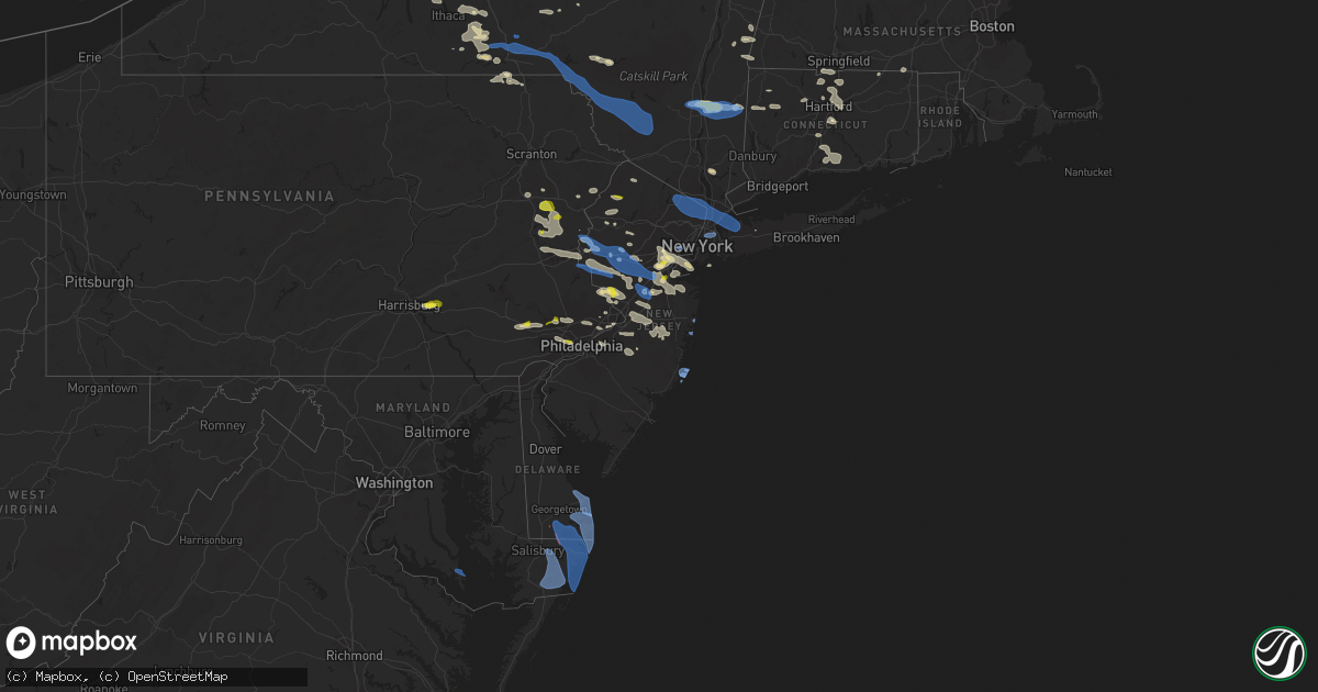
Hail Map in New Jersey on July 6, 2021
Get this storm
July 6 map
$229
one time, instant access
Download today. No call, no setup
Keep the $229
Bought the map and want the full workflow? Apply the entire $229 to a subscription within 7 days. None of it is wasted.
Every map, not just this one
This buys you this map. Subscription and you get every map we run, in the markets you choose from a few cities to whole states to nationwide. Plus real-time alerts the moment a storm fires.
Contact data
Name, contact info, occupancy, even credit band for addresses in the footprint. You go from where it hit to who to call.
Become the source they trust
Unlimited branding weather history reports on demand. You already have the documented answer ready for the property owner, and you are the one who showed up with it.
Property data and RoofTrace estimates
Pull up any address you have got, its value and the exact code rules for that jurisdiction, straight from One Click Code. Then RoofTrace estimates the squares, pitch, and roof value, priced the way you price.
Storm reports in New Jersey
New Jersey
| Date | Description |
|---|---|
| 07/06/20216:20 PM CDT | Large tree down... Fence destroyed; time estimated from radar. |
| 07/06/20216:00 PM CDT | Damage to seven pine trees. Report via social media. |
| 07/06/20215:50 PM CDT | Fallen tree reported on house. |
| 07/06/20215:45 PM CDT | Outdoor tent blown down at empress diner. |
| 07/06/20215:45 PM CDT | Fallen tree reported on house. |
| 07/06/20215:40 PM CDT | Fallen tree reported on house. |
| 07/06/20215:37 PM CDT | Fallen tree reported on house. |
| 07/06/20215:34 PM CDT | Fallen tree reported on house. |
| 07/06/20215:31 PM CDT | Fallen tree on car. |
| 07/06/20215:30 PM CDT | Primary wires down... Tree across road. |
| 07/06/20215:30 PM CDT | Corrects previous tstm wnd dmg report from 1 wnw fair lawn. Outdoor tent blown down at empress diner. Time estimated from radar. |
| 07/06/20215:29 PM CDT | Corrects previous tstm wnd dmg report from 1 sse waldwick. Fallen tree reported on house. Time estimated from radar. |
| 07/06/20215:26 PM CDT | A local report indicates 58 MPH wind near NEWARK AIRPORT |
| 07/06/20215:22 PM CDT | Downed tree on garden state parkway southbound south of montvale service area. All lanes and left shoulder blocked. |
| 07/06/20215:22 PM CDT | Mping report of trees down. |
| 07/06/20215:20 PM CDT | Tree down on house in westwood. |
| 07/06/20215:20 PM CDT | Corrects previous tstm wnd dmg report from montvale. Fallen tree reported on house. |
| 07/06/20215:20 PM CDT | Downed tree on garden state parkway southbound at exit 149. |
| 07/06/20215:18 PM CDT | Corrects previous tstm wnd dmg report from 1 se hawthorne. Fallen tree reported on house. Time estimated from radar. |
| 07/06/20215:18 PM CDT | Report from mping: trees uprooted or snapped; roof blown off. Time corrected based on radar. |
| 07/06/20215:15 PM CDT | Tree down on century road between paramus and saddle river road. |
| 07/06/20215:15 PM CDT | Trees and branches down on route 208 from fair lawn to oakland on both north and sound bound sides. |
| 07/06/20215:15 PM CDT | Tree down on soldier hill road. |
| 07/06/20215:10 PM CDT | Public reports trees down... Garbage cans littering street. |
| 07/06/20215:10 PM CDT | Tree limb down on i-287 southbound near boonton. Report via social media. Time estimated from radar. |
| 07/06/20215:08 PM CDT | Tree down at doty rd and rt. 202. Road closed in one direction. |
| 07/06/20215:06 PM CDT | Large tree branch brought down power lines in roadway. Time estimated from radar. Report via social media. |
| 07/06/20215:00 PM CDT | Multiple trees down... Corrected to indicate damage was from thunderstorm. |
| 07/06/20214:55 PM CDT | Several branches and limbs down. Time estimated from radar. |
| 07/06/20214:50 PM CDT | Trees and wires down. North beach road closed due to downed utility pole. Brady road from north cherry to espanong road closed due to down tree / lines. Time estimated |
| 07/06/20214:50 PM CDT | Photo of branch down in yard on social media. Time estimated from radar. |
| 07/06/20214:46 PM CDT | Photo of large limb down on power lines on social media. Time estimated from radar. |
| 07/06/20214:45 PM CDT | Trees and wires... Power poles down. Time estimated from radar. |
| 07/06/20214:42 PM CDT | A few large branches down. Time estimated from radar. Report via social media. |
| 07/06/20214:38 PM CDT | Video of up to quarter size hail. Time estimated from radar. |
| 07/06/20214:33 PM CDT | Photos of several large branches down. Time estimated from radar. Report via social media. |
| 07/06/20214:25 PM CDT | Multiple trees down; time estimated from radar... Corrected to indicate damage was from thunderstorms. |
| 07/06/20215:02 AM CDT | At 1001 PM EDT, severe thunderstorms were located along a line extending from Newark to near Perth Amboy, moving southeast at 20 mph. HAZARD...60 mph wind gusts and quarter size hail. SOURCE...Radar indicated. IMPACT...Minor hail damage to vehicles is possible. Expect wind damage to trees and power lines. Severe thunderstorms will be near... Bayonne and Huguenot around 1010 PM EDT. Todt Hill around 1015 PM EDT. Tompkinsville and Oakwood around 1020 PM EDT. The Verrazano Narrows Bridge around 1025 PM EDT. Bay Ridge and Bensonhurst around 1030 PM EDT. Coney Island around 1035 PM EDT. Sheepshead Bay around 1040 PM EDT. |
| 07/06/20214:00 AM CDT | At 900 PM EDT, severe thunderstorms were located along a line extending from Union to near East Brunswick, moving southeast at 25 mph. HAZARD...60 mph wind gusts and quarter size hail. SOURCE...Radar indicated. IMPACT...Minor hail damage to vehicles is possible. Expect wind damage to trees and power lines. Severe thunderstorms will be near... Elizabeth and Linden around 915 PM EDT. Port Richmond around 925 PM EDT. Todt Hill and Huguenot around 930 PM EDT. Tompkinsville and Oakwood around 935 PM EDT. The Verrazano Narrows Bridge and Bay Ridge around 940 PM EDT. Coney Island around 945 PM EDT. |
| 07/06/20213:50 AM CDT | At 850 PM EDT, a severe thunderstorm was located over New Hope, or 12 miles northwest of Trenton, moving east at 35 mph. HAZARD...60 mph wind gusts and quarter size hail. SOURCE...Radar indicated. IMPACT...Minor damage to vehicles is possible. Wind damage to roofs, siding, trees, and power lines is possible. Locations impacted include... Trenton, East Brunswick, South Brunswick, North Brunswick, Ewing, Princeton, Jamesburg, Hightstown, Cranbury, Pennington, New Hope, Yardley, Hopewell, Allentown, Roosevelt, Rocky Hill, Stockton, Skillman, White Horse and Sergeantsville.This includes the following highways... New Jersey Turnpike between exits 8 and 9. Interstate 195 in New Jersey between mile markers 2 and 14. Interstate 295 in New Jersey between mile markers 61 and 76. |
| 07/06/20212:59 AM CDT | At 759 PM EDT, severe thunderstorms were located along a line extending from near Asbury Park to Roosevelt to Princeton, moving southeast at 35 mph. HAZARD...60 mph wind gusts and quarter size hail. SOURCE...Radar indicated. IMPACT...Minor damage to vehicles is possible. Wind damage to roofs, siding, trees, and power lines is possible. Locations impacted include... Toms River, Long Branch, Asbury Park, Lakewood, Middletown, Old Bridge, Jackson, Howell, East Brunswick, South Brunswick, Marlboro, Manalapan, Tinton Falls, Holmdel, Princeton, Red Bank, Matawan, Jamesburg, Manasquan and Hightstown.This includes the following highways... New Jersey Turnpike between exits 8A and 9. Interstate 195 in New Jersey between mile markers 7 and 34. Garden State Parkway between mile markers 83 and 119. |
| 07/06/20211:41 AM CDT | At 641 PM EDT, severe thunderstorms were located along a line extending from near Bridgewater to Riegelsville, moving east at 40 mph. HAZARD...60 mph wind gusts and quarter size hail. SOURCE...Radar indicated. IMPACT...Minor damage to vehicles is possible. Wind damage to roofs, siding, trees, and power lines is possible. Locations impacted include... Trenton, South Brunswick, Manalapan, Ewing, Princeton, Byram, Hightstown, Flemington, Tinicum, Cranbury, High Bridge, Clinton, Pennington, New Hope, Yardley, Hopewell, Glen Gardner, Frenchtown, Lebanon and Milford.This includes the following highways... New Jersey Turnpike between exits 8A and 9. Interstate 78 in New Jersey between mile markers 7 and 22. Interstate 295 in New Jersey between mile markers 65 and 76. |
| 07/05/202111:29 PM CDT | At 428 PM EDT, severe thunderstorms were located along a line extending from near Royal to Moscow to Penobscot, moving east at 40 mph. HAZARD...60 mph wind gusts and quarter size hail. SOURCE...Radar indicated. IMPACT...Minor damage to vehicles is possible. Wind damage to roofs, siding, trees, and power lines is possible. Locations impacted include... Mount Pocono, East Stroudsburg, Tobyhanna, Wind Gap, Stormville, Werry Lake, Pocono Pines, Lake Harmony, Skytop, Tannersville, Long Pond, Kresgeville, Sun Valley, Reeders, Saylorsburg, McMichael, Canadensis, Blakeslee, Penn Forest Reservoir and Christmans.This includes the following highways... Northeast Extension between mile markers 81 and 97. Interstate 80 in Pennsylvania between mile markers 277 and 314. Interstate 380 in Pennsylvania between mile markers 0 and 12. |
| 07/05/20219:10 PM CDT | Trees and wires reported down in roselle. |
| 07/05/20218:45 PM CDT | Trees and wires down in westfield. |
| 07/05/20218:31 PM CDT | Mping report. |
| 07/05/20218:24 PM CDT | Numerous trees snapped and uprooted in hopewell twp. Time estimated from radar. |
| 07/05/20217:56 PM CDT | A large tree fell and other branches and limbs are down in the area from what appears to have been a downburst. Time estimated from radar. |
| 07/05/20217:39 PM CDT | Mping report of small tree limbs broken and/or power poles downed. |
All States Impacted by Hail Map on July 6, 2021
Cities Impacted by Hail Map on July 6, 2021
- Lake City, MN
- Merna, NE
- Broken Bow, NE
- Callaway, NE
- Billings, MT
- Saint Xavier, MT
- Hardin, MT
- Lavina, MT
- Crow Agency, MT
- Broadview, MT
- Shepherd, MT
- Huntley, MT
- Birney, MT
- Zortman, MT
- Cheyenne Wells, CO
- Harrison Township, MI
- Lodge Grass, MT
- Weskan, KS
- Newell, SD
- Dresden, KS
- Lebanon, NE
- Norcatur, KS
- Selden, KS
- Oberlin, KS
- Holmen, WI
- Trempealeau, WI
- Galesville, WI
- Mindoro, WI
- Anton Chico, NM
- Las Vegas, NM
- Elwood, NE
- Cozad, NE
- Lexington, NE
- Smithfield, NE
- South Egremont, MA
- Copake, NY
- Copake Falls, NY
- Hillsdale, NY
- Willard, NM
- Ansley, NE
- Rocky Hill, CT
- Union Center, SD
- Marshfield, WI
- Ord, NE
- Burwell, NE
- Elyria, NE
- Hillsboro, KY
- Decker, MT
- Otter, MT
- Lame Deer, MT
- Musselshell, MT
- White Haven, PA
- Lake Harmony, PA
- Busby, MT
- Tucumcari, NM
- Norwich, NY
- Oxford, NY
- Mount Upton, NY
- Guilford, NY
- Comstock, NE
- Sargent, NE
- Harlem, MT
- Hays, MT
- Chinook, MT
- Malta, MT
- Hogeland, MT
- Hershey, PA
- Hummelstown, PA
- Pittsfield, MA
- Willard, WI
- Hasty, CO
- Moriarty, NM
- Albrightsville, PA
- Blakeslee, PA
- Burlington, NJ
- Bristol, PA
- Florence, NJ
- Clinton Township, MI
- Bighorn, MT
- Forsyth, MT
- Hysham, MT
- Gothenburg, NE
- Maxwell, NE
- Brady, NE
- Frenchtown, NJ
- Pittstown, NJ
- Arvada, WY
- Clearmont, WY
- Lee, MA
- Otis, MA
- Becket, MA
- Chester, MA
- Tyringham, MA
- Blandford, MA
- Las Animas, CO
- Walsenburg, CO
- Titusville, NJ
- Lambertville, NJ
- Pennington, NJ
- Pepin, WI
- Mondovi, WI
- Nelson, WI
- Stockholm, WI
- Reads Landing, MN
- Alma, WI
- Wabasha, MN
- Durand, WI
- Clayton, NM
- Colonia, NJ
- Westfield, NJ
- Cranford, NJ
- Linden, NJ
- Edison, NJ
- Plainfield, NJ
- Rahway, NJ
- South Plainfield, NJ
- Scotch Plains, NJ
- Metuchen, NJ
- Clark, NJ
- Staten Island, NY
- Avenel, NJ
- Garwood, NJ
- Iselin, NJ
- Carteret, NJ
- Mountainside, NJ
- Irvington, KY
- Phillipsburg, NJ
- Milford, NJ
- Coplay, PA
- Schnecksville, PA
- Bethlehem, PA
- Easton, PA
- Hellertown, PA
- Whitehall, PA
- Allentown, PA
- Northampton, PA
- Catasauqua, PA
- Trenton, NE
- Stratton, NE
- Wyola, MT
- Ranchester, WY
- Dayton, WY
- Huntington Station, NY
- Criders, VA
- Buffalo, SD
- Brusett, MT
- Trinchera, CO
- Flemington, NJ
- Dodson, MT
- Cohagen, MT
- Sand Springs, MT
- Jordan, MT
- Lloyd, MT
- Texline, TX
- Armour, SD
- Hanover, IN
- Custer, MT
- Ingomar, MT
- Pueblo, CO
- Mud Butte, SD
- Cut Bank, MT
- Broadway, VA
- Warren, MA
- Millstone Township, NJ
- Hightstown, NJ
- Monroe Township, NJ
- Cranbury, NJ
- Princeton Junction, NJ
- Colby, KS
- Franklin, WV
- Glenmoore, PA
- Chester Springs, PA
- Downingtown, PA
- Pritchett, CO
- Indianola, NE
- Trementina, NM
- Wagon Mound, NM
- Hyde Park, NY
- Pleasant Valley, NY
- Highland, NY
- Poughkeepsie, NY
- Stewartsville, NJ
- Bloomsbury, NJ
- Washington, NJ
- Asbury, NJ
- Hampton, NJ
- Somerset, NJ
- Franklin Park, NJ
- Princeton, NJ
- New Hope, PA
- Rochester, MN
- Byron, MN
- Ithaca, NY
- Trumansburg, NY
- Rexford, KS
- Hinsdale, MA
- Middlefield, MA
- Pemberton, NJ
- Felt, OK
- Grapeland, TX
- Granton, WI
- Chili, WI
- Bertrand, NE
- Andes, NY
- Delancey, NY
- Fort Sumner, NM
- Austerlitz, NY
- Chatham, NY
- East Chatham, NY
- Newtown Square, PA
- Hoxie, KS
- Weyauwega, WI
- Waupaca, WI
- Dover Plains, NY
- Millbrook, NY
- West Cornwall, CT
- Goshen, CT
- Yorktown Heights, NY
- Cortlandt Manor, NY
- Croton On Hudson, NY
- Huntington, TX
- Helmetta, NJ
- Old Bridge, NJ
- Shelby, MT
- Reva, SD
- Salt Point, NY
- Weston, CO
- West Chesterfield, MA
- Hamden, NY
- Hixton, WI
- Osseo, WI
- Altura, MN
- Lewiston, MN
- Utica, MN
- Rollingstone, MN
- Warrens, WI
- Paris, KY
- Greenwood, WI
- Endicott, NY
- Owego, NY
- Kresgeville, PA
- Gilbert, PA
- Saylorsburg, PA
- Danielsville, PA
- Kunkletown, PA
- Effort, PA
- Brodheadsville, PA
- Jim Thorpe, PA
- Bath, PA
- Walnutport, PA
- Lehighton, PA
- Nazareth, PA
- Wind Gap, PA
- Palmerton, PA
- Webster, KY
- Harned, KY
- King Ferry, NY
- Scipio Center, NY
- Genoa, NY
- Union Springs, NY
- Aurora, NY
- Moravia, NY
- Ripon, WI
- Croydon, PA
- Spencer, WI
- Sayreville, NJ
- South River, NJ
- Winneconne, WI
- Berkeley Heights, NJ
- Summit, NJ
- Piscataway, NJ
- Fanwood, NJ
- Woodbridge, NJ
- Roselle, NJ
- Fords, NJ
- New Providence, NJ
- Grenville, NM
- Harrisburg, PA
- Middletown, PA
- Elizabethtown, PA
- McCook, NE
- Neillsville, WI
- Pittsville, WI
- Flemingsburg, KY
- Fairmont, MN
- Candor, NY
- Fremont, WI
- Easthampton, MA
- Huntington, MA
- East Windsor, CT
- Broad Brook, CT
- Windsor Locks, CT
- Suffield, CT
- Enfield, CT
- Gladstone, NJ
- Far Hills, NJ
- Peapack, NJ
- Warnerville, NY
- Richmondville, NY
- Humbird, WI
- Fairchild, WI
- Aguilar, CO
- Cuervo, NM
- Junction City, WI
- Milladore, WI
- Rudolph, WI
- Southbridge, MA
- Sturbridge, MA
- North Platte, NE
- Lebanon, NJ
- Whitehouse Station, NJ
- Melrose, WI
- Ettrick, WI
- Winona, MN
- Bangor, PA
- Feasterville Trevose, PA
- Montrose, PA
- New Egypt, NJ
- Chesterfield, NJ
- Robbinsville, NJ
- Cream Ridge, NJ
- Allentown, NJ
- Trenton, NJ
- Jackson, NJ
- West Suffield, CT
- Manchester Township, NJ
- Brandywine, WV
- Fulks Run, VA
- Wautoma, WI
- Redgranite, WI
- Wild Rose, WI
- Hopewell, NJ
- Lawrence Township, NJ
- Newtown, PA
- Washington Crossing, PA
- Holly, MI
- Lakehurst, NJ
- Morehead, KY
- Salt Lick, KY
- Brooksville, KY
- Lawrenceburg, KY
- Salvisa, KY
- Stafford Springs, CT
- Turner, MT
- Columbus, NJ
- Bordentown, NJ
- Wrightstown, NJ
- Joint Base Mdl, NJ
- Jobstown, NJ
- Wallingford, KY
- Alpha, MN
- Bergton, VA
- Dryden, NY
- Marathon, NY
- Ryegate, MT
- Linden, MI
- Grand Blanc, MI
- Fenton, MI
- Catlettsburg, KY
- Louisa, KY
- Pine River, WI
- Poy Sippi, WI
- Berlin, WI
- Sheffield, MA
- Southfield, MA
- Great Barrington, MA
- Mill River, MA
- Rochester, NY
- New Baltimore, MI
- Newton, NJ
- Arapahoe, CO
- Langhorne, PA
- Matawan, NJ
- Hazlet, NJ
- Milltown, NJ
- Lincroft, NJ
- Spotswood, NJ
- Marlboro, NJ
- East Brunswick, NJ
- Morganville, NJ
- New Brunswick, NJ
- Colts Neck, NJ
- Holmdel, NJ
- North Brunswick, NJ
- Parlin, NJ
- Englishtown, NJ
- Middletown, NJ
- Highland Park, NJ
- Kent, CT
- South Kent, CT
- Cornwall Bridge, CT
- East Stroudsburg, PA
- Hardinsburg, KY
- Sedan, NM
- Larsen, WI
- New Salem, MA
- Gilbertsville, NY
- South New Berlin, NY
- Bingham Lake, MN
- Harrodsburg, KY
- Germantown, KY
- Mosquero, NM
- Berkshire, NY
- Newark Valley, NY
- Wassaic, NY
- Verbank, NY
- New Paltz, NY
- Bushkill, PA
- Tamiment, PA
- Philadelphia, PA
- Broomall, PA
- Haverford, PA
- Drexel Hill, PA
- Upper Darby, PA
- Bryn Mawr, PA
- Wynnewood, PA
- Havertown, PA
- Vincentown, NJ
- Binghamton, NY
- Brackney, PA
- Mount Laurel, NJ
- Moorestown, NJ
- Phoenixville, PA
- Norristown, PA
- Locke, NY
- Lansing, NY
- Meriden, CT
- Hallstead, PA
- Cloudcroft, NM
- Sarepta, LA
- Quinebaug, CT
- North Grosvenordale, CT
- Woodstock, CT
- Dudley, MA
- Martinsville, NJ
- Loomis, NE
- Eustis, NE
- Willow Island, NE
- Bridgewater, NJ
- Bedminster, NJ
- Garita, NM
- Florence, MA
- Northampton, MA
- Brooktondale, NY
- Willseyville, NY
- Lisle, NY
- Richford, NY
- South Windsor, CT
- Hartford, CT
- Manchester, CT
- East Hartford, CT
- Windsor, CT
- Hackettstown, NJ
- Great Meadows, NJ
- Otego, NY
- Laurens, NY
- Spencer, NY
- Durham, CT
- Wallingford, CT
- Madison, CT
- North Branford, CT
- Killingworth, CT
- Guilford, CT
- Amelia, NE
- Bensalem, PA
- Granby, CT
- East Granby, CT
- Jackson, MN
- Windom, MN
- Camp Crook, SD
- Annandale, NJ
- West Hartford, CT
- Bloomfield, CT
- Welcome, MN
- Sherburn, MN
- Honey Brook, PA
- Malvern, PA
- Upper Black Eddy, PA
- Hillsborough, NJ
- Springer, NM
- Vestal, NY
- Portland, CT
- Cromwell, CT
- South Glastonbury, CT
- Blairstown, NJ
- Andover, NJ
- Atwood, KS
- Bangor, WI
- Monson, MA
- Rineyville, KY
- Vine Grove, KY
- Lynn, MA
- Saugus, MA
- Sussex, NJ
- Wethersfield, CT
- Blue Bell, PA
- Ambler, PA
- Plymouth Meeting, PA
- Mendham, NJ
- Chester, NJ
- Flanders, NJ
- West Stockbridge, MA
- Ghent, NY
- Little Meadows, PA
- Friendsville, PA
- Pendleton, KY
- Rockaway Park, NY
- Breezy Point, NY
- Craryville, NY
- Hudson, NY
- Roscoe, NY
- Walton, NY
- Downsville, NY
- Bantam, CT
- Litchfield, CT
- Skillman, NJ
- Rocky Hill, NJ
- Belle Mead, NJ
- Monmouth Junction, NJ
- Dayton, NJ
- Vona, CO
- Pocono Lake, PA
- Califon, NJ
- Oldwick, NJ
- Bardstown, KY
- Abington, PA
- Jenkintown, PA
- Glenside, PA
- Huntingdon Valley, PA
- Willow Grove, PA
- Cortland, NY
- Freeville, NY
- Worthington, MA
- Avon, CT
- Burlington, CT
- Canton, CT
- Circleville, WV
- Blue Grass, VA
- Versailles, KY
- Key West, FL
- North Port, FL
- Boca Grande, FL
- Englewood, FL
- Placida, FL
- Arcadia, FL
- Rotonda West, FL
- Port Charlotte, FL
- Myakka City, FL
- Sarasota, FL
- Anna Maria, FL
- Port Richey, FL
- Saint Petersburg, FL
- Belleair Beach, FL
- Dunedin, FL
- Cortez, FL
- Clearwater Beach, FL
- Bradenton, FL
- Pinellas Park, FL
- Tarpon Springs, FL
- Hudson, FL
- Clearwater, FL
- Largo, FL
- Bradenton Beach, FL
- Indian Rocks Beach, FL
- Palm Harbor, FL
- New Port Richey, FL
- Crystal Beach, FL
- Ruskin, FL
- Seminole, FL
- Palmetto, FL
- Longboat Key, FL
- Holiday, FL
- Mayo, FL
- Cross City, FL
- Chiefland, FL
- Old Town, FL
- Perry, FL
- Steinhatchee, FL
- Live Oak, FL
- Horseshoe Beach, FL
- Salem, FL
- Cedar Key, FL
- Jekyll Island, GA
- Waverly, GA
- Saint Simons Island, GA
- Brunswick, GA
- Woodbine, GA
- Saint Marys, GA
- Kings Bay, GA
- Jacksonville, FL
- Sapelo Island, GA
- Darien, GA
- Savannah, GA
- Beaufort, SC
- Tybee Island, GA
- Saint Helena Island, SC
- Ridgeland, SC
- Hilton Head Island, SC
- Daufuskie Island, SC
- Port Royal, SC
- Bluffton, SC
- Okatie, SC
- Sylvania, GA
- Newington, GA
- Edisto Island, SC
- Macclesfield, NC
- Fountain, NC
- Walstonburg, NC
- Edward, NC
- Ernul, NC
- Pinetown, NC
- Washington, NC
- Bath, NC
- Blounts Creek, NC
- Pantego, NC
- Hertford, NC
- Elizabeth City, NC
- Gates, NC
- Suffolk, VA
- Gatesville, NC
- Sunbury, NC
- Corapeake, NC
- Hobbsville, NC
- Belhaven, NC
- Lexington Park, MD
- Dameron, MD
- Salisbury, MD
- Snow Hill, MD
- Pocomoke City, MD
- Girdletree, MD
- Stockton, MD
- Pittsville, MD
- Parsonsburg, MD
- Selbyville, DE
- Newark, MD
- Whaleyville, MD
- Laurel, DE
- Berlin, MD
- Georgetown, DE
- Frankford, DE
- Showell, MD
- Ocean City, MD
- Bishopville, MD
- Willards, MD
- Millsboro, DE
- Dagsboro, DE
- Lewes, DE
- Milton, DE
- Rehoboth Beach, DE
- Bethany Beach, DE
- Fenwick Island, DE
- Ocean View, DE
- Millville, DE
- Beach Haven, NJ
- Barnegat Light, NJ
- Roundup, MT
- Ballantine, MT
- Parkman, WY
- Recluse, WY
- Gillette, WY
- Le Roy, NY
- Stafford, NY
- Byron, NY
- Batavia, NY
- Bergen, NY
- Webster, NY
- Greene, NY
- Greenfield Park, NY
- Mountain Dale, NY
- Castle Creek, NY
- Mongaup Valley, NY
- Glen Wild, NY
- Fishs Eddy, NY
- Woodbourne, NY
- Wurtsboro, NY
- Livingston Manor, NY
- Ellenville, NY
- Liberty, NY
- Fallsburg, NY
- Maine, NY
- Kiamesha Lake, NY
- White Sulphur Springs, NY
- Harpursville, NY
- Youngsville, NY
- Hancock, NY
- Port Crane, NY
- Johnson City, NY
- Loch Sheldrake, NY
- Fremont Center, NY
- Hankins, NY
- Rock Hill, NY
- Bloomingburg, NY
- Harris, NY
- Hurleyville, NY
- Swan Lake, NY
- Kenoza Lake, NY
- Long Eddy, NY
- Jeffersonville, NY
- North Branch, NY
- Deposit, NY
- Woodridge, NY
- Starlight, PA
- Afton, NY
- Monticello, NY
- Glen Aubrey, NY
- Nineveh, NY
- Callicoon, NY
- South Fallsburg, NY
- Hortonville, NY
- Ferndale, NY
- Chenango Forks, NY
- Lagrangeville, NY
- Poughquag, NY
- Sparkill, NY
- Ramsey, NJ
- Tappan, NY
- Mamaroneck, NY
- Tuckahoe, NY
- Westwood, NJ
- Dumont, NJ
- Ridgewood, NJ
- Montvale, NJ
- Harrington Park, NJ
- Tenafly, NJ
- Port Washington, NY
- Demarest, NJ
- Greenvale, NY
- Dobbs Ferry, NY
- Ho Ho Kus, NJ
- Spring Valley, NY
- Rye, NY
- Larchmont, NY
- Sea Cliff, NY
- Mahwah, NJ
- Locust Valley, NY
- River Edge, NJ
- Glenwood Landing, NY
- Piermont, NY
- Oyster Bay, NY
- Hawthorne, NJ
- Park Ridge, NJ
- New Milford, NJ
- Ardsley, NY
- Oakland, NJ
- Franklin Lakes, NJ
- Alpine, NJ
- Yonkers, NY
- Blauvelt, NY
- Paramus, NJ
- Closter, NJ
- Township Of Washington, NJ
- Pelham, NY
- Glen Rock, NJ
- Woodcliff Lake, NJ
- Oradell, NJ
- Bronxville, NY
- Fair Lawn, NJ
- Bergenfield, NJ
- Norwood, NJ
- Hillsdale, NJ
- Midland Park, NJ
- Northvale, NJ
- Scarsdale, NY
- Hastings On Hudson, NY
- Haworth, NJ
- Emerson, NJ
- Saddle River, NJ
- Eastchester, NY
- Mount Vernon, NY
- Roslyn, NY
- Bronx, NY
- Glen Head, NY
- Palisades, NY
- Glen Cove, NY
- Nyack, NY
- Waldwick, NJ
- Pearl River, NY
- Cresskill, NJ
- Wyckoff, NJ
- Orangeburg, NY
- Allendale, NJ
- New Rochelle, NY
- Astoria, NY
- College Point, NY
- New York, NY
- Flushing, NY
- Whitestone, NY
- East Elmhurst, NY
- New Underwood, SD
- Sturgis, SD
- Stratford, WI
- Strum, WI
- Augusta, WI
- Loyal, WI
- Auburndale, WI
- Gayville, SD
- Vermillion, SD
- Mission Hill, SD
- Yankton, SD
- Three Bridges, NJ
- Martins Creek, PA
- Glen Gardner, NJ
- Neshanic Station, NJ
- High Bridge, NJ
- Clinton, NJ
- Flagtown, NJ
- Raritan, NJ
- Somerville, NJ
- Manville, NJ
- Elizabeth, NJ
- Newark, NJ
- Palmyra, PA
- Annville, PA
- Plainsboro, NJ
- Kingston, NJ
- Kendall Park, NJ
- Collegeville, PA
- Sea Girt, NJ
- Spring Lake, NJ
- Erwinna, PA
- Ringoes, NJ
- Kintnersville, PA
- Brick, NJ
- Mantoloking, NJ
- Oaks, PA


