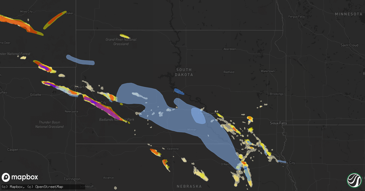
Hail Map in South Dakota on July 6, 2020
Get this storm
July 6 map
$229
one time, instant access
Download today. No call, no setup
Keep the $229
Bought the map and want the full workflow? Apply the entire $229 to a subscription within 7 days. None of it is wasted.
Every map, not just this one
This buys you this map. Subscription and you get every map we run, in the markets you choose from a few cities to whole states to nationwide. Plus real-time alerts the moment a storm fires.
Contact data
Name, contact info, occupancy, even credit band for addresses in the footprint. You go from where it hit to who to call.
Become the source they trust
Unlimited branding weather history reports on demand. You already have the documented answer ready for the property owner, and you are the one who showed up with it.
Property data and RoofTrace estimates
Pull up any address you have got, its value and the exact code rules for that jurisdiction, straight from One Click Code. Then RoofTrace estimates the squares, pitch, and roof value, priced the way you price.
Storm reports in South Dakota
South Dakota
| Date | Description |
|---|---|
| 07/06/20206:44 PM CDT | A local report indicates 60 MPH wind near 1 SE NORTH SIOUX CITY |
| 07/06/20205:34 PM CDT | Strong winds accompanied the hail... But no estimates on strength and no visible damage. |
| 07/06/20205:19 PM CDT | A pine tree with trunk diameter of 6 feet was downed due to the strong thunderstorm wind gusts. |
| 07/06/20205:10 PM CDT | Mesonet station 197 sd rwis gayville. |
| 07/06/20205:04 PM CDT | Dime sized hail and heavy rain along with strong winds. |
| 07/06/20204:42 PM CDT | Awos station kykn yankton municipal airport. |
| 07/06/20204:40 PM CDT | A couple of large trees toppled. Reported at 30546 hwy 81 yankton sd. |
| 07/06/20204:18 PM CDT | A couple of 4 inch diameter tree limbs down. |
| 07/06/20203:50 PM CDT | A local report indicates 1.00 inch wind near 3 W SHADEHILL |
| 07/06/20203:48 PM CDT | Reported at 29726 420th avvenue scotland sd. |
| 07/06/20202:48 PM CDT | Reported at 27609 427th avenue freeman sd. |
| 07/06/20202:25 PM CDT | Reported at 42199 hwy 44 parkston sd. |
| 07/06/20202:05 PM CDT | Heavy rain and some wind... But no damage. |
| 07/06/20202:00 PM CDT | Ping pong ball sized hail at the i-90 exit for alexandria. |
| 07/06/20202:00 PM CDT | A local report indicates 2.75 inch wind near ALEXANDRIA |
| 07/06/20201:43 PM CDT | Heavy rain and briefly gusty winds preceded the large hail. |
| 07/06/202010:47 AM CDT | Lots of hail... Some up to size of quarters... But mostly peas. Some of the corn and beans have stripped leaves... But it is not dead. 3.50 inches of rainfall. |
| 07/06/20208:15 AM CDT | Ground was covered with quarter to half dollar sized hail and ponding water around the acreage. Rainfall estimated at 1 inch. |
| 07/06/20206:54 AM CDT | At 1151 PM CDT, severe thunderstorms were located along a line extending from 8 miles southeast of Earling Hills to 5 miles northwest of Kilgore, moving east at 70 mph. HAZARD...70 mph wind gusts and quarter size hail. SOURCE...Radar indicated. IMPACT...Hail damage to vehicles is expected. Expect considerable tree damage. Wind damage is also likely to mobile homes, roofs, and outbuildings. Severe thunderstorms will be near... Littleburg around 1215 AM CDT. Winner around 1225 AM CDT Millboro around 1235 AM CDT. Wewela around 1245 AM CDT. |
| 07/06/20206:46 AM CDT | At 1146 PM CDT, severe thunderstorms were located along a line extending from near Cedar Creek Rec Area to 13 miles south of 5 Mile Corner, moving east at 40 mph. HAZARD...60 mph wind gusts and nickel size hail. SOURCE...Radar indicated. IMPACT...Expect damage to roofs, siding, and trees. Severe thunderstorms will be near... Byre Lake around 1200 AM CDT. Medicine Butte around 1215 AM CDT. Reliance and Counselor Creek Boat Access Area around 1220 AM CDT. |
| 07/06/20206:35 AM CDT | At 1134 PM CDT, a severe thunderstorm was located near Grass Ranch Colony, or near Kimball, moving east at 30 mph. HAZARD...Half dollar size hail. SOURCE...Radar indicated. IMPACT...Damage to vehicles is expected. This severe thunderstorm will be near... Grass Ranch Colony around 1140 PM CDT. White Lake around 1200 AM CDT. |
| 07/06/20206:13 AM CDT | At 1112 PM CDT/1012 PM MDT/, severe thunderstorms were located along a line extending from 6 miles north of Blunt to 8 miles south of Pierre, moving east at 55 mph. HAZARD...60 mph wind gusts and penny size hail. SOURCE...Radar indicated. IMPACT...Expect damage to roofs, siding, and trees. Severe thunderstorms will be near... Blunt around 1120 PM CDT. Harrold around 1125 PM CDT. Degrey Rec Area around 1130 PM CDT. Holabird and Cedar Creek Rec Area around 1135 PM CDT. Joe Creek Rec Area around 1140 PM CDT. Highmore and West Bend Rec Area around 1145 PM CDT. Lower Brule around 1155 PM CDT. Lake Sharpe around 1200 AM CDT. |
| 07/06/20206:05 AM CDT | At 1105 PM CDT, a severe thunderstorm was located near Aurora Center, or 17 miles southwest of Plankinton, moving east at 10 mph. HAZARD...Ping pong ball size hail. SOURCE...Radar indicated. IMPACT...People and animals outdoors will be injured. Expect damage to roofs, siding, windows, and vehicles. This severe thunderstorm will be near... Aurora Center around 1125 PM CDT. New Holland around 1130 PM CDT. Harrison around 1145 PM CDT. |
| 07/06/20206:01 AM CDT | At 1100 PM CDT/1000 PM MDT/, severe thunderstorms were located along a line extending from near West Shore Rec Area to 10 miles southeast of Belvidere, moving east at 50 mph. HAZARD...60 mph wind gusts and nickel size hail. SOURCE...Radar indicated. IMPACT...Expect damage to roofs, siding, and trees. Severe thunderstorms will be near... Westover and Intersection of Highway 83 and White River around 1125 PM CDT. |
| 07/06/20205:46 AM CDT | At 1045 PM CDT, a severe thunderstorm was located near Armour, or 16 miles west of Parkston, moving southeast at 25 mph. HAZARD...Golf ball size hail. SOURCE...Radar indicated. IMPACT...People and animals outdoors will be injured. Expect damage to roofs, siding, windows, and vehicles. This severe thunderstorm will be near... Armour around 1055 PM CDT. Delmont around 1105 PM CDT. |
| 07/06/20205:42 AM CDT | At 1042 PM CDT, a severe thunderstorm was located near Kimball, moving east at 10 mph. HAZARD...Half dollar size hail. SOURCE...Radar indicated. IMPACT...Damage to vehicles is expected. This severe thunderstorm will be near... White Lake around 1130 PM CDT. |
| 07/06/20205:27 AM CDT | At 1026 PM CDT/926 PM MDT/, severe thunderstorms were located along a line extending from near Brown Church to near Kadoka, moving southeast at 35 mph. HAZARD...60 mph wind gusts and penny size hail. SOURCE...Radar indicated. IMPACT...Expect damage to roofs, siding, and trees. Severe thunderstorms will be near... Brown Church around 930 PM MDT. Hayes around 935 PM MDT. Wendte around 1110 PM CDT. |
| 07/06/20205:21 AM CDT | At 1020 PM CDT, a severe thunderstorm was located near Corsica, or 17 miles south of Plankinton, moving east at 20 mph. HAZARD...Ping pong ball size hail. SOURCE...Radar indicated. IMPACT...People and animals outdoors will be injured. Expect damage to roofs, siding, windows, and vehicles. This severe thunderstorm will remain over mainly rural areas of northeastern Douglas County to the north and northeast of Corsica. |
| 07/06/20204:24 AM CDT | At 923 PM MDT/1023 PM CDT/, severe thunderstorms were located along a line extending from 3 miles northwest of Brown Church to 4 miles south of Interior, moving east at 40 mph. HAZARD...70 mph wind gusts and quarter size hail. SOURCE...Radar indicated. IMPACT...Hail damage to vehicles is expected. Expect considerable tree damage. Wind damage is also likely to mobile homes, roofs, and outbuildings. Severe thunderstorms will be near... Wanblee around 950 PM MDT. Norris around 1125 PM CDT.This includes Interstate 90 in South Dakota between Mile Markers 133and 174. |
| 07/06/20203:57 AM CDT | At 855 PM MDT, a severe thunderstorm was located 3 miles southeast of Wasta, or 35 miles west of Philip, moving southeast at 40 mph. HAZARD...60 mph wind gusts and penny size hail. SOURCE...Radar indicated. IMPACT...Expect damage to roofs, siding, and trees. This severe thunderstorm will be near... Wall and northeastern Badlands National Park around 905 PM MDT. Quinn and Pinnacles Ranger Station around 915 PM MDT. Interior around 935 PM MDT. Cedar Pass around 940 PM MDT.This includes Interstate 90 in South Dakota between Mile Markers 95and 140. |
| 07/06/20203:56 AM CDT | At 856 PM MDT, a severe thunderstorm was located over western Badlands National Park, or 42 miles southeast of Rapid City, moving southeast at 35 mph. HAZARD...Tennis ball size hail and 60 mph wind gusts. SOURCE...Trained weather spotters. IMPACT...People and animals outdoors will be injured. Expect hail damage to roofs, siding, windows, and vehicles. Expect wind damage to roofs, siding, and trees. This severe thunderstorm will be near... Kyle around 945 PM MDT. Potato Creek around 955 PM MDT. |
| 07/06/20203:10 AM CDT | At 809 AM CDT, a severe thunderstorm was located over Winfred, or 11 miles west of Lake Herman State Park, moving northeast at 25 mph. HAZARD...60 mph wind gusts and quarter size hail. SOURCE...Radar indicated. IMPACT...Hail damage to vehicles is expected. Expect wind damage to roofs, siding, and trees. This severe thunderstorm will be near... Lake Herman State Park around 835 AM CDT. Ramona around 840 AM CDT. Madison around 845 AM CDT. Nunda around 900 AM CDT. |
| 07/06/20203:07 AM CDT | At 807 PM MDT, a severe thunderstorm was located 5 miles northwest of Viewfield, or 23 miles northeast of Rapid City, moving east at 35 mph. HAZARD...60 mph wind gusts and quarter size hail. SOURCE...Radar indicated. IMPACT...Hail damage to vehicles is expected. Expect wind damage to roofs, siding, and trees. This severe thunderstorm will be near... Viewfield around 815 PM MDT. Curlew Lake around 820 PM MDT. Elm Springs around 835 PM MDT.This includes Interstate 90 in South Dakota between Mile Markers 87and 106. |
| 07/06/20202:58 AM CDT | At 757 PM MDT, a severe thunderstorm was located near Black Gap, or 9 miles southeast of Rapid City, moving southeast at 40 mph. HAZARD...Tennis ball size hail and 60 mph wind gusts. SOURCE...Trained weather spotters. IMPACT...People and animals outdoors will be injured. Expect hail damage to roofs, siding, windows, and vehicles. Expect wind damage to roofs, siding, and trees. This severe thunderstorm will be near... Caputa around 805 PM MDT. Farmingdale around 815 PM MDT. Scenic around 845 PM MDT. Sheep Mountain Table around 850 PM MDT. |
| 07/06/20202:40 AM CDT | At 739 PM MDT, a severe thunderstorm was located near Maurine, or 25 miles west of Faith, moving east at 30 mph. HAZARD...60 mph wind gusts and quarter size hail. SOURCE...Radar indicated. IMPACT...Hail damage to vehicles is expected. Expect wind damage to roofs, siding, and trees. This severe thunderstorm will be near... Faith and Durkee Lake around 830 PM MDT. |
| 07/06/20202:13 AM CDT | At 712 PM MDT, a severe thunderstorm was located 3 miles southwest of Bear Butte State Park, or 3 miles northeast of Sturgis, moving southeast at 30 mph. HAZARD...60 mph wind gusts and quarter size hail. SOURCE...Radar indicated. IMPACT...Hail damage to vehicles is expected. Expect wind damage to roofs, siding, and trees. This severe thunderstorm will remain over mainly rural areas of southwestern Meade County east of Sturgis to Hereford.This includes Interstate 90 in South Dakota between Mile Markers 29and 41. |
| 07/06/20202:11 AM CDT | At 709 PM MDT, a severe thunderstorm was located 3 miles southeast of Roubaix Lake, or 14 miles southeast of Lead, moving southeast at 30 mph. HAZARD...60 mph wind gusts and quarter size hail. SOURCE...Radar indicated. IMPACT...Hail damage to vehicles is expected. Expect wind damage to roofs, siding, and trees. This severe thunderstorm will be near... Nemo, Silver City, Pactola Reservoir and Dalton Lake around 720 PM MDT. Piedmont around 725 PM MDT. Johnson Siding around 730 PM MDT. Black Hawk and Hisega around 735 PM MDT. Rapid City around 745 PM MDT. Rapid Valley around 755 PM MDT.This includes Interstate 90 in South Dakota between Mile Markers 42and 71. |
| 07/06/20202:09 AM CDT | At 708 PM MDT, a severe thunderstorm was located near Hoover, or 37 miles south of Buffalo, moving east at 35 mph. HAZARD...60 mph wind gusts and quarter size hail. SOURCE...Radar indicated. IMPACT...Hail damage to vehicles is expected. Expect wind damage to roofs, siding, and trees. This severe thunderstorm will be near... Dears Ears Butte around 720 PM MDT. Mud Butte around 745 PM MDT. Maurine around 805 PM MDT. |
| 07/06/20201:47 AM CDT | At 646 PM CDT/546 PM MDT/, severe thunderstorms were located along a line extending from 6 miles southeast of Kilgore to 8 miles northeast of Medicine Lake, moving southeast at 25 mph. HAZARD...Golf ball size hail and 60 mph wind gusts. SOURCE...Radar indicated. IMPACT...People and animals outdoors will be injured. Expect hail damage to roofs, siding, windows, and vehicles. Expect wind damage to roofs, siding, and trees. Locations impacted include... Valentine, Cody, Kilgore, Nenzel, Crookston, Eli, Steer Creek Campground, Schoolhouse Lake, Cody Lake, Anderson Bridge State Wildlife Management Area and Big Alkali Lake.This includes the following highways... Highway 20 between mile markers 149 and 196, between mile markers199 and 204, and between mile markers 206 and 219. Highway 97 between mile markers 106 and 141. Highway 83 between mile markers 192 and 207. |
| 07/06/20201:40 AM CDT | Mesonet station 244 sd rwis ft. Randall dam. |
| 07/06/20201:31 AM CDT | At 630 PM CDT, severe thunderstorms were located along a line extending from near Elk Point to near Ponca to near Allen, moving east at 20 mph. HAZARD...70 mph wind gusts and penny size hail. SOURCE...Radar indicated. IMPACT...Expect considerable tree damage. Damage is likely to mobile homes, roofs, and outbuildings. Severe thunderstorms will be near... Jefferson around 640 PM CDT. North Sioux City, Emerson and Jackson In Dakota County around 645 PM CDT. Hubbard around 655 PM CDT. Sioux City, South Sioux City and Dakota City around 710 PM CDT. Sergeant Bluff, Hinton and Homer around 715 PM CDT.Other locations impacted by these severe thunderstorms includeWaterbury and Westfield. |
| 07/06/20201:21 AM CDT | At 620 PM MDT, a severe thunderstorm was located 4 miles southeast of Sundance, moving southeast at 35 mph. HAZARD...Ping pong ball size hail and 60 mph wind gusts. SOURCE...Radar indicated. IMPACT...People and animals outdoors will be injured. Expect hail damage to roofs, siding, windows, and vehicles. Expect wind damage to roofs, siding, and trees. This severe thunderstorm will be near... Moskee around 635 PM MDT. Cement Ridge Lookout around 640 PM MDT. O'Neil Pass and Roughlock Falls around 650 PM MDT. Cheyenne Crossing around 655 PM MDT. Black Fox Campground around 705 PM MDT. Flag Mountain around 710 PM MDT. Rochford and Roubaix Lake around 715 PM MDT.This includes Interstate 90 in Wyoming between Mile Markers 184 and195. |
| 07/06/20201:18 AM CDT | Mesonet station 154 sd rwis platte-winner bridge. |
| 07/06/20201:04 AM CDT | Mesonet station 154 sd rwis platte-winner bridge. |
| 07/06/202012:58 AM CDT | Asos station k9v9 chamberlain municipal airport... Called in and listened to the minute by minute observations. |
| 07/06/202012:45 AM CDT | At 545 PM CDT, a severe thunderstorm was located 5 miles southwest of Maskell, or 12 miles southwest of Vermillion, moving southeast at 25 mph. HAZARD...60 mph wind gusts and quarter size hail. SOURCE...Radar indicated. IMPACT...Hail damage to vehicles is expected. Expect wind damage to roofs, siding, and trees. Locations impacted include... Hartington, Coleridge, Wynot, Laurel, Pleasant Valley, Belden, Magnet, Obert, Brooky Bottom and Camp Assurance. |
| 07/06/202012:38 AM CDT | A local report indicates 83 MPH wind near 3 SE RELIANCE |
| 07/06/202012:33 AM CDT | At 532 PM CDT, a severe thunderstorm was located over Maskell, or 9 miles southwest of Vermillion, moving southeast at 30 mph. HAZARD...60 mph wind gusts and half dollar size hail. SOURCE...Radar indicated. IMPACT...Hail damage to vehicles is expected. Expect wind damage to roofs, siding, and trees. This severe thunderstorm will be near... Newcastle around 545 PM CDT. Martinsburg around 605 PM CDT. |
| 07/06/202012:30 AM CDT | A local report indicates 75 MPH wind near 2 W HAMILL |
| 07/06/202012:28 AM CDT | At 528 PM CDT, a severe thunderstorm was located near Wynot, or 12 miles west of Vermillion, moving south at 15 mph. HAZARD...60 mph wind gusts and half dollar size hail. SOURCE...Radar indicated. IMPACT...Hail damage to vehicles is expected. Expect wind damage to roofs, siding, and trees. This severe thunderstorm will remain over mainly rural areas of southwestern Clay and southeastern Yankton Counties, including the following locations... Gayville. |
| 07/06/202012:26 AM CDT | At 526 PM MDT, a severe thunderstorm was located 10 miles north of New Haven, or 39 miles northwest of Sundance, moving east at 40 mph. HAZARD...Golf ball size hail and 60 mph wind gusts. SOURCE...Radar indicated. IMPACT...People and animals outdoors will be injured. Expect hail damage to roofs, siding, windows, and vehicles. Expect wind damage to roofs, siding, and trees. This severe thunderstorm will be near... Alva around 600 PM MDT. Bear Lodge Campground around 610 PM MDT. Aladdin around 620 PM MDT.This includes Interstate 90 in Wyoming between Mile Markers 204 and207. |
| 07/06/202012:25 AM CDT | A local report indicates 63 MPH wind near 2 W HAMILL |
| 07/06/202012:21 AM CDT | A local report indicates 68 MPH wind near 1 NE WINNER |
| 07/06/202012:20 AM CDT | Roof blown off house |
| 07/06/202012:19 AM CDT | A local report indicates 64 MPH wind near 1 NE WINNER |
| 07/06/202012:09 AM CDT | A local report indicates 70 MPH wind near 10 SSE PRESHO |
| 07/06/202012:06 AM CDT | At 506 PM CDT, severe thunderstorms were located along a line extending from near Lewis And Clark State Recreation Area to 5 miles southwest of Niobrara, moving east at 10 mph. HAZARD...60 mph wind gusts and quarter size hail. SOURCE...Radar indicated. IMPACT...Hail damage to vehicles is expected. Expect wind damage to roofs, siding, and trees. Locations impacted include... Verdigre, Niobrara, Santee, Crofton, Lewis And Clark State Recreation Area and Lindy. |
| 07/06/202012:04 AM CDT | A local report indicates 61 MPH wind near 4 SSE WITTEN |
| 07/06/202012:00 AM CDT | A local report indicates 63 MPH wind near 7 ESE ROSEBUD |
| 07/06/202012:00 AM CDT | At 500 PM CDT, a severe thunderstorm was located near Mission Hill, or 5 miles southeast of Yankton, moving southeast at 15 mph. HAZARD...60 mph wind gusts. SOURCE...Radar indicated. IMPACT...Expect damage to roofs, siding, and trees. Locations impacted include... Wynot, St. Helena, Obert, Gavins Point Dam And Campgrounds and Brooky Bottom. |
| 07/05/202011:59 PM CDT | A local report indicates 71 MPH wind near 12 NW IDEAL |
| 07/05/202011:51 PM CDT | A local report indicates 64 MPH wind near 1 E PRESHO |
| 07/05/202011:50 PM CDT | At 450 PM CDT, a severe thunderstorm was located over Volin, or 13 miles northeast of Yankton, moving east at 10 mph. HAZARD...Golf ball size hail and 70 mph wind gusts. SOURCE...Radar indicated. IMPACT...People and animals outdoors will be injured. Expect hail damage to roofs, siding, windows, and vehicles. Expect considerable tree damage. Wind damage is also likely to mobile homes, roofs, and outbuildings. This severe thunderstorm will be near... Wakonda around 510 PM CDT.Other locations impacted by this severe thunderstorm include Gayvilleand St. Helena Boat Dock. |
| 07/05/202011:37 PM CDT | At 437 AM CDT, a severe thunderstorm was located over Orland, or near Lake Herman State Park, moving northeast at 25 mph. HAZARD...60 mph wind gusts. SOURCE...Radar indicated. IMPACT...Expect damage to roofs, siding, and trees. This severe thunderstorm will be near... Madison around 455 AM CDT. Chester around 500 AM CDT. Wentworth around 505 AM CDT. |
| 07/05/202011:34 PM CDT | A local report indicates 63 MPH wind near 9 NNW VIVIAN |
| 07/05/202011:09 PM CDT | A local report indicates 60 MPH wind near 1 W PIERRE |
| 07/05/202010:57 PM CDT | A local report indicates 64 MPH wind near 9 ENE BELVIDERE |
| 07/05/202010:52 PM CDT | A local report indicates 70 MPH wind near 1 NE MIDLAND |
| 07/05/202010:49 PM CDT | Hail as large as quarters... But mostly nickles or smaller. Some bean leaves ripped up... But not too bad. Not too much wind. Rainfall 1.60 inches. |
| 07/05/202010:47 PM CDT | A local report indicates 70 MPH wind near 1 NE MIDLAND |
| 07/05/202010:47 PM CDT | Corrects previous hail report from 4 nne armour |
| 07/05/202010:42 PM CDT | A local report indicates 65 MPH wind near 1 NE MIDLAND |
| 07/05/202010:39 PM CDT | At 339 PM CDT, a severe thunderstorm was located near Kaylor, or 7 miles north of Tyndall, moving east at 15 mph. HAZARD...Quarter size hail. SOURCE...Radar indicated. IMPACT...Damage to vehicles is expected. This severe thunderstorm will be near... Scotland around 405 PM CDT. Tabor around 430 PM CDT. |
| 07/05/202010:31 PM CDT | A local report indicates 64 MPH wind near 1 NNE HAYES |
| 07/05/202010:25 PM CDT | A local report indicates 60 MPH wind near 13 NE ROCKYFORD |
| 07/05/202010:25 PM CDT | A local report indicates 61 MPH wind near 4 W OTTUMWA |
| 07/05/202010:25 PM CDT | A local report indicates 1.00 inch wind near 13 NE ROCKYFORD |
| 07/05/202010:23 PM CDT | Received report from law enforcement... Time estimated from radar. |
| 07/05/202010:19 PM CDT | A local report indicates 64 MPH wind near 3 E PHILIP |
| 07/05/20209:58 PM CDT | A local report indicates 60 MPH wind near 3 NW WASTA |
| 07/05/20209:45 PM CDT | A local report indicates 60 MPH wind near 4 SE USTA |
| 07/05/20209:44 PM CDT | At 244 PM MDT, a severe thunderstorm was located over northern Shadehill Reservoir, or 12 miles south of Lemmon, moving east at 15 mph. HAZARD...Half dollar size hail. SOURCE...Radar indicated. IMPACT...Damage to vehicles is expected. This severe thunderstorm will be near... Shadehill around 255 PM MDT. |
| 07/05/20209:41 PM CDT | At 241 PM CDT, a severe thunderstorm was located near Clayton, or 14 miles east of Parkston, moving east at 15 mph. HAZARD...Quarter size hail. SOURCE...Radar indicated. IMPACT...Damage to vehicles is expected. This severe thunderstorm will be near... Clayton around 250 PM CDT. Freeman around 330 PM CDT. |
| 07/05/20209:30 PM CDT | A local report indicates 2.50 inch wind near 4 SE FOLSOM |
| 07/05/20209:21 PM CDT | At 221 PM CDT, a severe thunderstorm was located near Milltown, or 10 miles east of Parkston, moving east at 10 mph. HAZARD...Quarter size hail. SOURCE...Radar indicated. IMPACT...Damage to vehicles is expected. This severe thunderstorm will remain over mainly rural areas of central Hutchinson County. |
| 07/05/20209:17 PM CDT | A local report indicates 1.75 inch wind near 14 SSE HEREFORD |
| 07/05/20209:17 PM CDT | A local report indicates 60 MPH wind near 14 SSE HEREFORD |
| 07/05/20209:15 PM CDT | Estimated 50 mph winds |
| 07/05/20209:02 PM CDT | A local report indicates 2.00 inch wind near 7 SW RAPID CITY ARPT |
| 07/05/20209:01 PM CDT | At 201 PM CDT, a severe thunderstorm was located near Tabor, or 8 miles west of Lewis And Clark State Recreation Area, moving northeast at 5 mph. HAZARD...Half dollar size hail. SOURCE...Radar indicated. IMPACT...Damage to vehicles is expected. This severe thunderstorm will be near... Tabor around 235 PM CDT.Other locations impacted by this severe thunderstorm include LewisAnd Clark State Recreation Area and Lesterville. |
| 07/05/20208:58 PM CDT | At 157 PM CDT, a severe thunderstorm was located over Alexandria, or 13 miles east of Mitchell, moving southeast at 15 mph. HAZARD...Ping pong ball size hail and 60 mph wind gusts. SOURCE...Trained weather spotters. IMPACT...People and animals outdoors will be injured. Expect hail damage to roofs, siding, windows, and vehicles. Expect wind damage to roofs, siding, and trees. This severe thunderstorm will be near... Alexandria around 200 PM CDT. Farmer around 205 PM CDT. Emery around 240 PM CDT. |
| 07/05/20208:55 PM CDT | 45-50 mph winds |
| 07/05/20208:55 PM CDT | A local report indicates 1.25 inch wind near 8 S DWTN RAPID CITY |
| 07/05/20208:51 PM CDT | A local report indicates 2.00 inch wind near 4 S DWTN RAPID CITY |
| 07/05/20208:51 PM CDT | A local report indicates 2.00 inch wind near 3 S DWTN RAPID CITY |
| 07/05/20208:50 PM CDT | A local report indicates 1.25 inch wind near 1 E DWTN RAPID CITY |
| 07/05/20208:49 PM CDT | A local report indicates 2.50 inch wind near 3 SSW DWTN RAPID CITY |
| 07/05/20208:48 PM CDT | A local report indicates 2.50 inch wind near 3 WSW DWTN RAPID CITY |
| 07/05/20208:45 PM CDT | Started 740 pm to 750 pm |
| 07/05/20208:45 PM CDT | Lasted 5 minutes |
| 07/05/20208:44 PM CDT | A local report indicates 2.00 inch wind near 4 NE ROCKERVILLE |
| 07/05/20208:38 PM CDT | Relayed by friend of nws employee |
| 07/05/20208:36 PM CDT | Just started |
| 07/05/20208:35 PM CDT | A local report indicates 1.00 inch wind near 1 N HISEGA |
| 07/05/20208:34 PM CDT | At 134 PM CDT, a severe thunderstorm was located over Fulton, or 12 miles east of Mitchell, moving east at 15 mph. HAZARD...Quarter size hail. SOURCE...Radar indicated. IMPACT...Damage to vehicles is expected. This severe thunderstorm will be near... Farmer around 155 PM CDT. |
| 07/05/20208:30 PM CDT | A local report indicates 1.50 inch wind near 7 W DWTN RAPID CITY |
| 07/05/20208:30 PM CDT | A local report indicates 1.00 inch wind near 3 N JOHNSON SIDING |
| 07/05/20208:30 PM CDT | A local report indicates 1.00 inch wind near 5 NW JOHNSON SIDING |
| 07/05/20208:25 PM CDT | A local report indicates 60 MPH wind near STURGIS |
| 07/05/20208:13 PM CDT | A local report indicates 1.00 inch wind near 6 SSE BROWNSVILLE |
| 07/05/20208:10 PM CDT | A local report indicates 60 MPH wind near HOOVER |
| 07/05/20207:45 PM CDT | 1/2 inch hail |
All States Impacted by Hail Map on July 6, 2020
Cities Impacted by Hail Map on July 6, 2020
- White Lake, WI
- Fall Creek, WI
- Augusta, WI
- Cadott, WI
- Sheboygan, WI
- Highland Park, NJ
- Iselin, NJ
- East Brunswick, NJ
- Woodbridge, NJ
- South Amboy, NJ
- Fords, NJ
- Sewaren, NJ
- Piscataway, NJ
- New Brunswick, NJ
- Avenel, NJ
- Metuchen, NJ
- Perth Amboy, NJ
- Port Reading, NJ
- Keasbey, NJ
- Sayreville, NJ
- Edison, NJ
- South Plainfield, NJ
- North Brunswick, NJ
- New Providence, PA
- Kirkwood, PA
- Nottingham, PA
- Quarryville, PA
- Peach Bottom, PA
- Malvern, PA
- Paoli, PA
- Norristown, PA
- King Of Prussia, PA
- Mont Clare, PA
- Wayne, PA
- Berwyn, PA
- Phoenixville, PA
- Oaks, PA
- Necedah, WI
- Meadow Grove, NE
- Tilden, NE
- Kimball, SD
- Cincinnati, OH
- Falmouth, KY
- Rapid City, SD
- Circle, MT
- Sloan, IA
- Shohola, PA
- Greeley, PA
- Colby, WI
- Kutztown, PA
- New Tripoli, PA
- Kempton, PA
- Fogelsville, PA
- Sherwood, MD
- Butternut, WI
- Park Falls, WI
- Bensalem, PA
- Croydon, PA
- Bordentown, NJ
- Langhorne, PA
- Burlington, NJ
- Fairless Hills, PA
- Philadelphia, PA
- Robbinsville, NJ
- Florence, NJ
- Roebling, NJ
- Levittown, PA
- Allentown, NJ
- Bristol, PA
- Riverside, NJ
- Trenton, NJ
- Chesterfield, NJ
- Morrisville, PA
- Orchard, NE
- Sundance, WY
- Harris, NY
- Ferndale, NY
- Liberty, NY
- Loch Sheldrake, NY
- Monticello, NY
- Hurleyville, NY
- Caputa, SD
- Westboro, WI
- Petersburg, NE
- Royal, NE
- Bloomfield, NE
- Lesterville, SD
- Springfield, SD
- Avon, SD
- Dixon, NE
- Elgin, NE
- Niobrara, NE
- Creighton, NE
- Waterbury, NE
- Clearwater, NE
- Newcastle, NE
- Laurel, NE
- Gayville, SD
- Utica, SD
- Saint Helena, NE
- Lindsay, NE
- Newman Grove, NE
- Irene, SD
- Tabor, SD
- Wynot, NE
- Madison, NE
- Verdigre, NE
- Tyndall, SD
- Plainview, NE
- Menno, SD
- Ponca, NE
- Neligh, NE
- Brunswick, NE
- Winnetoon, NE
- Ewing, NE
- Hartington, NE
- Yankton, SD
- Pierce, NE
- Crofton, NE
- Scotland, SD
- Vermillion, SD
- Center, NE
- Volin, SD
- Mission Hill, SD
- Ruckersville, VA
- Madison, VA
- Stanardsville, VA
- Hood, VA
- Otter, MT
- Lancaster, PA
- Newport, NJ
- Lanoka Harbor, NJ
- Bayville, NJ
- Beachwood, NJ
- Forked River, NJ
- Port Republic, NJ
- Nesquehoning, PA
- Livingston Manor, NY
- North Branch, NY
- Jeffersonville, NY
- Kenoza Lake, NY
- Callicoon, NY
- Coopersburg, PA
- Center Valley, PA
- Alexandria, SD
- Fulton, SD
- Emery, SD
- Fortescue, NJ
- Armour, SD
- Brandywine, MD
- Alexandria, VA
- Washington, DC
- Andrews Air Force Base, MD
- Upper Marlboro, MD
- District Heights, MD
- Clinton, MD
- Oxon Hill, MD
- Accokeek, MD
- Fort Washington, MD
- Suitland, MD
- Temple Hills, MD
- Aquasco, MD
- Palm City, FL
- Strasburg, PA
- Jamestown, ND
- Newberry, MI
- Parkston, SD
- Freeman, SD
- Olivet, SD
- Hulett, WY
- Hysham, MT
- New Hope, PA
- Sturgis, SD
- Sanders, MT
- Hovland, MN
- Grand Marais, MN
- Roundup, MT
- Gladstone, MI
- Rapid River, MI
- Rock, MI
- Chinook, MT
- Ringtown, PA
- Zion Grove, PA
- Hazleton, PA
- Sheppton, PA
- Barry, TX
- Orr, MN
- Milesville, SD
- Philip, SD
- Zortman, MT
- Forsyth, MT
- Grahamsville, NY
- Ellenville, NY
- Moorcroft, WY
- Mitchell, SD
- Grenloch, NJ
- Blackwood, NJ
- Hays, MT
- Deadwood, SD
- Hermosa, SD
- Scenic, SD
- Nemo, SD
- Grand Marais, MI
- Perkasie, PA
- Ottsville, PA
- New Underwood, SD
- Gore, VA
- Winchester, VA
- Turon, KS
- Cunningham, KS
- Cheltenham, PA
- Elkins Park, PA
- Wyncote, PA
- Glenside, PA
- Murdo, SD
- Weston, WY
- Petersburg, WV
- Upper Tract, WV
- Rosebud, MT
- Ewen, MI
- Athens, WI
- Weyauwega, WI
- Williamstown, KY
- Berry, KY
- Rome, PA
- Alburtis, PA
- Gilbertsville, PA
- Barto, PA
- Bechtelsville, PA
- Oley, PA
- Boyertown, PA
- Mount Sterling, KY
- Winchester, KY
- Bird In Hand, PA
- Shafer, MN
- Center City, MN
- Cody, NE
- Essex, MD
- Dundalk, MD
- New Rochelle, NY
- Port Washington, NY
- Bronx, NY
- Locust Valley, NY
- Glen Cove, NY
- Bowie, MD
- Eubank, KY
- La Plata, MD
- Hughesville, MD
- Charlotte Hall, MD
- Parksville, NY
- Ronks, PA
- Willow Street, PA
- Thedford, NE
- Valentine, NE
- Munising, MI
- Shingleton, MI
- Arkdale, WI
- Cleveland, WI
- Jackson, MN
- Veedersburg, IN
- Loyal, WI
- Stapleton, NE
- Arnold, NE
- Clay City, KY
- Richey, MT
- Wood Ridge, NJ
- Carlstadt, NJ
- Teterboro, NJ
- Moonachie, NJ
- Hasbrouck Heights, NJ
- Passaic, NJ
- Rochelle Park, NJ
- Ridgefield Park, NJ
- Paramus, NJ
- Saddle Brook, NJ
- Ridgefield, NJ
- East Rutherford, NJ
- Lodi, NJ
- Secaucus, NJ
- Maywood, NJ
- Hackensack, NJ
- Wallington, NJ
- South Hackensack, NJ
- Fair Lawn, NJ
- Little Ferry, NJ
- Glasgow, MT
- Lemmon, SD
- Clarks Hill, IN
- Frankfort, IN
- Tripp, SD
- Bangor, WI
- Hunter, ND
- Arthur, ND
- West Chester, PA
- Downingtown, PA
- Kennett Square, PA
- Chadds Ford, PA
- Mount Vernon, NY
- Bronxville, NY
- Blooming Grove, TX
- Lumberton, NJ
- Mount Laurel, NJ
- Marlton, NJ
- Medford, NJ
- Osceola, NE
- Monroe, NE
- Shelby, NE
- Columbus, NE
- Platte Center, NE
- Rising City, NE
- Bellwood, NE
- Duncan, NE
- Chalfont, PA
- Horsham, PA
- North Wales, PA
- Ambler, PA
- Warrington, PA
- Stevens, PA
- Denver, PA
- Ephrata, PA
- Sardinia, OH
- Capitol Heights, MD
- Elk Horn, KY
- Volborg, MT
- Corinth, KY
- Cornell, MI
- Madison, SD
- Weatherly, PA
- Jim Thorpe, PA
- Musselshell, MT
- Barnard, KS
- Lincoln, KS
- Big Falls, MN
- Wilmington, OH
- Melbourne, KY
- Newport, KY
- Silver Grove, KY
- New Holland, SD
- Corsica, SD
- Harrison, SD
- Platte, SD
- Geddes, SD
- White Lake, SD
- Delmont, SD
- Stickney, SD
- Fordyce, NE
- Wynnewood, PA
- Bala Cynwyd, PA
- Narberth, PA
- Ardmore, PA
- Merion Station, PA
- Spring City, PA
- Devon, PA
- Collegeville, PA
- Lafayette, IN
- Andover, MN
- Green Lake, WI
- Saint Croix Falls, WI
- Dresser, WI
- Tioga, PA
- Middlebury Center, PA
- Campbell, NY
- Summit Hill, PA
- Staten Island, NY
- Glenn Dale, MD
- Sparrows Point, MD
- Middle River, MD
- White Marsh, MD
- Lead, SD
- Ramona, SD
- Winter, WI
- Mount Vernon, KY
- Orlando, KY
- Lake Linden, MI
- Lakeview, OH
- Wapakoneta, OH
- Elmira, NY
- Horseheads, NY
- Sudlersville, MD
- Somers Point, NJ
- Malta, MT
- Mays Landing, NJ
- Lyndhurst, VA
- Stuarts Draft, VA
- Stephenson, MI
- Reliance, SD
- New Lisbon, WI
- Mauston, WI
- Sayre, PA
- Louisville, KY
- Owanka, SD
- Little Meadows, PA
- Warren Center, PA
- Owen, WI
- Winfred, SD
- Northampton, PA
- Markesan, WI
- Newark, DE
- Chester Springs, PA
- Exton, PA
- Royersford, PA
- Pottstown, PA
- Glenmoore, PA
- Nekoosa, WI
- South Windsor, CT
- Broad Brook, CT
- East Windsor, CT
- Johnstown, NE
- Woodhull, NY
- Addison, NY
- Allentown, PA
- Whitehall, PA
- Lynchburg, OH
- Hillsboro, OH
- Lloyd, MT
- Allen, SD
- Morristown, NJ
- Egg Harbor City, NJ
- Hammonton, NJ
- Spearfish, SD
- Bridgeton, NJ
- Millville, NJ
- Cresco, PA
- Kearneysville, WV
- Caneyville, KY
- Laurel, MD
- Bladensburg, MD
- Lanham, MD
- Hyattsville, MD
- Beltsville, MD
- College Park, MD
- Greenbelt, MD
- Riverdale, MD
- Irvine, KY
- Beloit, KS
- Worton, MD
- Lake Tomahawk, WI
- Rhinelander, WI
- Gillette, NJ
- Chatham, NJ
- New Providence, NJ
- Berkeley Heights, NJ
- Valley Head, WV
- Pound, WI
- Thorofare, NJ
- Paulsboro, NJ
- Mantua, NJ
- Wenonah, NJ
- Woodbury Heights, NJ
- Woodbury, NJ
- Sewell, NJ
- Dushore, PA
- Belfry, KY
- Williamson, WV
- South Williamson, KY
- Waldorf, MD
- Bryantown, MD
- Paragon, IN
- Nenzel, NE
- Kilgore, NE
- Centuria, WI
- Luck, WI
- Taylors Falls, MN
- Littlefork, MN
- Ely, MN
- Ellettsville, IN
- Sioux City, IA
- Potter, NE
- Jackson, NJ
- Howell, NJ
- Lakewood, NJ
- Milltown, WI
- Cushing, WI
- White River, SD
- Sparta, WI
- Crandon, WI
- Mahanoy City, PA
- Shenandoah, PA
- Richland, MT
- Larslan, MT
- Hummelstown, PA
- Hershey, PA
- Martinsville, IN
- Woodbourne, NY
- White Lake, NY
- Smallwood, NY
- Mongaup Valley, NY
- Cochecton, NY
- Roscoe, NY
- South Fallsburg, NY
- Bethel, NY
- Swan Lake, NY
- Youngsville, NY
- Long Pine, NE
- Bassett, NE
- Wagner, SD
- Black River Falls, WI
- Bethlehem, PA
- Hellertown, PA
- Richlandtown, PA
- Quakertown, PA
- Burnett, WI
- Hancock, WI
- Englewood Cliffs, NJ
- Fort Lee, NJ
- Rockland, WI
- Cashton, WI
- West Salem, WI
- La Crosse, WI
- Warwick, MD
- Chesapeake City, MD
- Jessup, MD
- Severn, MD
- Fort George G Meade, MD
- Hanover, MD
- Portage, WI
- Custer, MT
- Worden, MT
- Midland, SD
- Franklinville, NJ
- Chassell, MI
- Chilton, WI
- White Plains, MD
- Kermit, WV
- Crum, WV
- Camden, TN
- Holladay, TN
- Cameron Mills, NY
- Bear, DE
- Elkton, MD
- Glen Spey, NY
- Highland Lake, NY
- Perkins, MI
- Escanaba, MI
- Wilson, MI
- Bark River, MI
- Mehoopany, PA
- Peerless, MT
- Vida, MT
- South Charleston, OH
- Farmingdale, NJ
- Oakdale, NE
- Vincentown, NJ
- Mount Holly, NJ
- Columbus, NJ
- Pemberton, NJ
- Jobstown, NJ
- Whitewood, SD
- Broadus, MT
- Tomahawk, WI
- Howard, SD
- Genoa, NE
- Quinwood, WV
- Bergland, MI
- Englishtown, NJ
- Ranson, WV
- Charles Town, WV
- Shenandoah Junction, WV
- Rosemount, MN
- Hill City, SD
- Pine Ridge, SD
- Kyle, SD
- Gambrills, MD
- North East, MD
- Rising Sun, MD
- Stevensville, MD
- Reedsville, WI
- Callaway, NE
- Lower Brule, SD
- Amasa, MI
- Whitewater, MT
- Ethan, SD
- Gleason, WI
- Campton, KY
- Milltown, NJ
- Henryville, PA
- Liberty, KY
- Science Hill, KY
- Bethelridge, KY
- Saint Edward, NE
- Slatedale, PA
- Slatington, PA
- New Holland, PA
- Gap, PA
- East Earl, PA
- Narvon, PA
- Stratford, NJ
- Cherry Hill, NJ
- Somerdale, NJ
- Moorestown, NJ
- Maple Shade, NJ
- Haddonfield, NJ
- Lawnside, NJ
- Voorhees, NJ
- Hainesport, NJ
- Clementon, NJ
- Gibbsboro, NJ
- Eldred, NY
- Brodhead, KY
- Belvidere, SD
- Long Valley, SD
- Tobyhanna, PA
- Kiel, WI
- Wellington, KY
- Crivitz, WI
- Kaylor, SD
- Ainsworth, NE
- Purdon, TX
- Eagle River, WI
- Stoneham, CO
- Brush, CO
- Burwell, NE
- McKee, KY
- Corsicana, TX
- Burke, SD
- Annapolis, MD
- Italy, TX
- Windsor, CT
- Cedar, MN
- Wilson, KS
- Brick, NJ
- Osceola, WI
- Alva, WY
- Williamstown, NJ
- The Villages, FL
- Leola, PA
- Fort Meade, SD
- Douglassville, PA
- Wrightstown, NJ
- Cream Ridge, NJ
- Greenwood, WI
- Taylor, NE
- Leonia, NJ
- Englewood, NJ
- Clifton, NJ
- Verona, NJ
- New York, NY
- Teaneck, NJ
- Nutley, NJ
- Garfield, NJ
- Bloomfield, NJ
- Elmwood Park, NJ
- North Bergen, NJ
- Cedar Grove, NJ
- Rutherford, NJ
- Montclair, NJ
- Bogota, NJ
- Edgewater, NJ
- Palisades Park, NJ
- Fountainville, PA
- Doylestown, PA
- Sidney, NE
- Cayuta, NY
- River Edge, NJ
- Fairview, NJ
- West New York, NJ
- Summit Point, WV
- Middletown, DE
- Frankston, TX
- Bullard, TX
- Daggett, MI
- Coleman, WI
- Lake Wilson, MN
- Troupsburg, NY
- Hot Springs, VA
- Trenary, MI
- Chatham, MI
- Pardeeville, WI
- Bunker Hill, WV
- Monroe Township, NJ
- Pipersville, PA
- Dublin, PA
- Ewing, KY
- Andreas, PA
- Tamaqua, PA
- Lehighton, PA
- New Ringgold, PA
- Crookston, NE
- Fallsburg, NY
- Pleasant Mount, PA
- Amery, WI
- Cartwright, ND
- Hortonville, WI
- Holmen, WI
- Mindoro, WI
- Valders, WI
- La Farge, WI
- Haverford, PA
- Lafayette Hill, PA
- Beverly, NJ
- Blue Bell, PA
- Plymouth Meeting, PA
- Conshohocken, PA
- Havertown, PA
- Fort Washington, PA
- Jenkintown, PA
- Oreland, PA
- Flourtown, PA
- Palmyra, NJ
- Dalton, WI
- Montello, WI
- Lisco, NE
- Cochranville, PA
- Atglen, PA
- Lyons, CO
- Pukwana, SD
- Lavina, MT
- Marenisco, MI
- Toms River, NJ
- Lakehurst, NJ
- Manchester Township, NJ
- Freehold, NJ
- Warm Springs, VA
- Plymouth, WI
- Sheboygan Falls, WI
- Sadieville, KY
- Draper, SD
- Baltimore, MD
- Rosedale, MD
- Millwood, KY
- Cook, MN
- Millersville, MD
- Crownsville, MD
- Jackson, KY
- Cedarville, NJ
- Clear Brook, VA
- Gerrardstown, WV
- Willard, WI
- Valley Mills, TX
- Dry Ridge, KY
- Mescalero, NM
- Heron Lake, MN
- Sicklerville, NJ
- Vale, SD
- Melrose, WI
- Oshkosh, NE
- Whiting, IA
- Stephenson, VA
- Belle Fourche, SD
- Manasquan, NJ
- Sea Girt, NJ
- Brielle, NJ
- Fort Thomas, KY
- Pearson, WI
- Fond Du Lac, WI
- Hillsboro, WI
- South Solon, OH
- Nancy, KY
- Russell Springs, KY
- Port Saint Lucie, FL
- Fort Pierce, FL
- Schuylkill Haven, PA
- Pottsville, PA
- Centreville, MD
- Chestertown, MD
- Bethel, OH
- Mount Orab, OH
- Frost, TX
- Basking Ridge, NJ
- Madison, NJ
- Green Village, NJ
- New Vernon, NJ
- Kadoka, SD
- Mertztown, PA
- Breinigsville, PA
- Macungie, PA
- Trexlertown, PA
- Interior, SD
- Caldwell, NJ
- Lyndhurst, NJ
- Glen Ridge, NJ
- Cliffside Park, NJ
- Little Falls, NJ
- Belleville, NJ
- North Arlington, NJ
- Mechanicsburg, PA
- Crab Orchard, KY
- Waterford Works, NJ
- Atco, NJ
- Berlin, NJ
- Sapello, NM
- Ogema, WI
- Okaton, SD
- Equinunk, PA
- London, KY
- Wyoming, MN
- Wibaux, MT
- Pequea, PA
- Conestoga, PA
- Mount Olivet, KY
- White Sulphur Springs, WV
- Barryville, NY
- Hubbard, NE
- Union, KY
- Chisago City, MN
- Wood Lake, NE
- Kerhonkson, NY
- Yulan, NY
- Lackawaxen, PA
- Hawley, PA
- Milford, PA
- Narrowsburg, NY
- Huntsville, OH
- Milford, OH
- Batavia, OH
- Kintnersville, PA
- Absecon, NJ
- Chatsworth, NJ
- Saint Paul, MN
- Glassboro, NJ
- Goshen, OH
- Loveland, OH
- Ponderosa, NM
- Jemez Springs, NM
- Spooner, WI
- Monrovia, IN
- Quincy, IN
- Pelican Lake, WI
- Ribera, NM
- Pecos, NM
- Dayton, MN
- Carney, MI
- Glen Burnie, MD
- Pasadena, MD
- Windsor, KY
- Ocean View, NJ
- Marmora, NJ
- Egg Harbor Township, NJ
- Woodbine, NJ
- Ocean City, NJ
- Leota, MN
- Jewell, KS
- Buena, NJ
- Harrisburg, PA
- Brooklyn, NY
- Chappell, NE
- Christiana, PA
- Ontonagon, MI
- Bruce Crossing, MI
- Watersmeet, MI
- Oxford, PA
- Smoketown, PA
- Lititz, PA
- East Petersburg, PA
- Saint Marie, MT
- Opheim, MT
- Plevna, MT
- Baker, MT
- Ismay, MT
- Newell, SD
- Alzada, MT
- Naper, NE
- Gregory, SD
- Winner, SD
- White Owl, SD
- Oneill, NE
- Ideal, SD
- Wood, SD
- Saint Charles, SD
- Lake Andes, SD
- Kennebec, SD
- Bristow, NE
- Fort Pierre, SD
- Okreek, SD
- Wanblee, SD
- Quinn, SD
- Mission, SD
- Vivian, SD
- Cherry Creek, SD
- Page, NE
- Wasta, SD
- Wall, SD
- Fairfax, SD
- Lynch, NE
- Bonesteel, SD
- Hamill, SD
- Mills, NE
- Dallas, SD
- Stuart, NE
- Butte, NE
- Norris, SD
- Hayes, SD
- Pickstown, SD
- Howes, SD
- Spencer, NE
- Herrick, SD
- Oacoma, SD
- Chamberlain, SD
- Witten, SD
- Presho, SD
- Atkinson, NE
- Colome, SD
- Pierre, SD
- Jackson, NE
- Jefferson, SD
- North Sioux City, SD
- Devils Tower, WY
- Cedar Knolls, NJ
- Morris Plains, NJ
- Whippany, NJ
- Mamaroneck, NY
- Larchmont, NY
- Hightstown, NJ
- Newfoundland, PA
- Canadensis, PA
- Apalachin, NY
- Friendsville, PA
- Vestal, NY
- Brackney, PA
- Lawrenceville, PA
- New Milford, NJ
- Bergenfield, NJ
- Florham Park, NJ
- Ridgewood, NJ
- Oradell, NJ
- Glen Rock, NJ
- Yonkers, NY
- Pelham, NY
- Barnesville, PA
- Palmyra, PA
- Vernon Rockville, CT
- Ellington, CT
- Naval Anacost Annex, DC
- Arlington, VA
- Harwood, MD
- Davidsonville, MD
- Odenton, MD
- Severna Park, MD
- Greenwood, DE
- Houston, DE
- Rock Hall, MD
- Barclay, MD
- Church Hill, MD
- Denton, MD
- Marydel, MD
- Ridgely, MD
- Henderson, MD
- Queen Anne, MD
- Greensboro, MD
- Harrington, DE
- Lincoln, DE
- Goldsboro, MD
- Felton, DE
- Bridgeville, DE
- Seaford, DE


