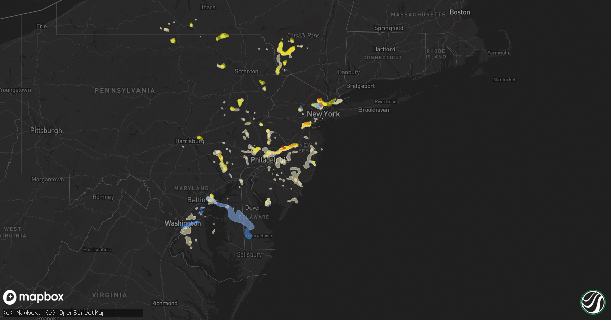
Hail Map in New Jersey on July 6, 2020
Get this storm
July 6 map
$229
one time, instant access
Download today. No call, no setup
Keep the $229
Bought the map and want the full workflow? Apply the entire $229 to a subscription within 7 days. None of it is wasted.
Every map, not just this one
This buys you this map. Subscription and you get every map we run, in the markets you choose from a few cities to whole states to nationwide. Plus real-time alerts the moment a storm fires.
Contact data
Name, contact info, occupancy, even credit band for addresses in the footprint. You go from where it hit to who to call.
Become the source they trust
Unlimited branding weather history reports on demand. You already have the documented answer ready for the property owner, and you are the one who showed up with it.
Property data and RoofTrace estimates
Pull up any address you have got, its value and the exact code rules for that jurisdiction, straight from One Click Code. Then RoofTrace estimates the squares, pitch, and roof value, priced the way you price.
Storm reports in New Jersey
New Jersey
| Date | Description |
|---|---|
| 07/06/20204:17 PM CDT | Trees and wires down in southeast of mertztown. Time estimated from radar. |
| 07/06/20203:45 PM CDT | Large tree limbs down blocking roadway |
| 07/06/20203:27 PM CDT | A local report indicates 1.00 inch wind near RIDGEWOOD |
| 07/06/20203:25 PM CDT | A local report indicates 1.00 inch wind near GLEN ROCK |
| 07/06/20203:24 PM CDT | A local report indicates 1.00 inch wind near FAIR LAWN |
| 07/06/20203:00 PM CDT | Tree down on madison ave. Time estimated from radar. |
| 07/06/20202:58 PM CDT | In addition to many quarter to ping pong ball sized hailstones. |
| 07/06/20202:56 PM CDT | A local report indicates 60 MPH wind near HASBROUCK HEIGHTS |
| 07/06/20202:55 PM CDT | A local report indicates 1.25 inch wind near HASBROUCK HEIGHTS |
| 07/06/20202:55 PM CDT | Tree down on maple ave. Time estimated from radar. |
| 07/06/20202:55 PM CDT | A large tree was downed on south st. Time estimated from radar. |
| 07/06/20202:52 PM CDT | A local report indicates 1.00 inch wind near LODI |
| 07/06/20202:48 PM CDT | Downed trees and wires near mount kemble avenue in new vernon. Time estimated from radar. |
| 07/06/20202:43 PM CDT | Reports of downed power lines in mendham. Time estimated from radar. |
| 07/06/20202:43 PM CDT | Downed trees and wires near jenks hill road in new vernon. Time estimated from radar. |
| 07/06/20202:40 PM CDT | Downed trees and wires near morris avenue in morristown. Time estimated from radar. |
| 07/06/20202:38 PM CDT | Downed trees and wires near speedwell avenue in morris plains. Time estimated from radar. |
| 07/06/20202:38 PM CDT | Trees and wires down in morris twp. Time estimated from radar. |
| 07/06/20202:37 PM CDT | Trees and wires down in morris plains. Time estimated from radar. |
| 07/06/20202:37 PM CDT | Corrects previous tstm wnd dmg report from morristown. Trees and wires down in morristown. Several cars were damaged or destroyed by the falling trees. Time estimated f |
| 07/06/20202:36 PM CDT | Corrects previous hail report from morristown. Quarter-sized hail at ginty field in morristown. Time modified based on radar... Social media information... And nearby h |
| 07/06/20202:35 PM CDT | A local report indicates 1.00 inch wind near PARAMUS |
| 07/06/20202:32 PM CDT | A local report indicates 1.00 inch wind near ROCHELLE PARK |
| 07/06/20202:30 PM CDT | Quarter-sized hail at ginty field in morristown. Time estimated from radar. |
| 07/06/20202:30 PM CDT | Trees and wires down near the intersection of whippany road and ford hill road near whippany. Time estimated from radar. |
| 07/06/20202:30 PM CDT | Nickel to quarter size hail. |
| 07/06/20202:28 PM CDT | Tree down on wires near ellis parkway in colonia. Time estimated from radar. |
| 07/06/20202:25 PM CDT | Quarter to ping pong ball size hail. |
| 07/06/20202:24 PM CDT | Report via social media with video of hail up to about quarter size. Some small dents on vehicles reported. Time estimated from radar. |
| 07/06/20202:20 PM CDT | A local report indicates 1.00 inch wind near 1 SSW SOUTH PLAINFIELD |
| 07/06/20202:20 PM CDT | A local report indicates 1.00 inch wind near 1 W PERTH AMBOY |
| 07/06/20202:10 PM CDT | Downed trees and wires near pleasant valley road in old bridge. Time estimated from radar. |
| 07/06/20202:08 PM CDT | Downed wires near sea girt avenue. Time estimated from radar. |
| 07/06/20202:00 PM CDT | Report via social media with photos. Time estimated from radar. |
| 07/06/20202:00 PM CDT | Downed trees and wires near ridgewood road in allenwood. Time estimated from radar. |
| 07/06/20201:45 PM CDT | Njweathernet site nj66. |
| 07/06/20201:45 PM CDT | A local report indicates 61 MPH wind near OCEAN COUNTY AIRPORT (K |
| 07/06/20201:40 PM CDT | Downed tree limbs and wires near wilson raod in englishtown. Time estimated from radar. |
| 07/06/20201:32 PM CDT | Reports of trees and wires down in lindenwold. Time estimated from radar. |
| 07/06/20201:26 PM CDT | Mping report. |
| 07/06/20201:23 PM CDT | Tree on wires on creek road at route 38 in hainesport. Time estimated from radar. |
| 07/06/20201:20 PM CDT | Multiple trees and wires down on route 73 in marlton. Report via social media. Time estimated from radar. |
| 07/06/20201:15 PM CDT | Downed wires on nj-73 both directions between brick rd and maple ave. All lanes closed and detoured. Time estimated from radar. |
| 07/06/20201:14 PM CDT | Downed tree limbs and wires near branch street in medford. Time estimated from radar. |
| 07/06/20201:11 PM CDT | Reports of tree limbs and wires down near georgia trail in medford. Time estimated from radar. |
| 07/06/20201:10 PM CDT | Report via social media with photos of ping pong ball size hail. |
| 07/06/20201:10 PM CDT | Report via social media with photo of hail a little larger than quarter size. Time estimated from radar. |
| 07/06/20201:10 PM CDT | Report via social media with photos of hail around quarter size. |
| 07/06/20201:08 PM CDT | Several reports of tree limbs and wires down in the evesboro and marlton areas. Time estimated from radar. |
| 07/06/20201:06 PM CDT | Several reports of trees and wires down in the springdale... Society hill... And ellisburg areas. Time estimated from radar. |
| 07/06/20201:06 PM CDT | Downed tree and wires near locust avenue in haddon twp. Time estimated from radar. |
| 07/06/20201:05 PM CDT | Report via social media with photo of hail to around quarter size. Time estimated from radar. |
| 07/06/20201:00 PM CDT | Report with photo of hail to about quarter size. |
| 07/06/20201:00 PM CDT | Downed wires near monmouth road in springfiled twp. Time estimated from radar. |
| 07/06/20201:00 PM CDT | Mainly penny size but a few stones to quarter size. Hail fell for around 15 minutes. |
| 07/06/202012:55 PM CDT | Tree limbs and wires down near columbia boulevard in cherry hill. Time estimated from radar. |
| 07/06/202012:53 PM CDT | Downed tree and wires near ashley lane in lumberton. Time estimated from radar. |
| 07/06/202012:47 PM CDT | Downed wires near green street in mount holly. Time estimated from radar. |
| 07/06/202011:51 AM CDT | Downed wires near riverside township high school. Time estimated from radar. |
| 07/06/202012:43 AM CDT | At 543 PM EDT, severe thunderstorms were located along a line extending from near Strathmere to near Cape May Court House to near Fortesque, moving east at 40 mph. HAZARD...60 mph wind gusts and quarter size hail. SOURCE...Radar indicated. IMPACT...Minor damage to vehicles is possible. Wind damage to roofs, siding, trees, and power lines is possible. Locations impacted include... Millville, Ocean City, Cape May, North Wildwood, Laurel Lake, Wildwood Crest, Woodbine, Sea Isle City, Estell Manor, Avalon, West Cape May, Stone Harbor, Corbin City, Newport, Cape May Court House, Leesburg, Scotch Bonnet, Beesleys Point, Seaville and Bricksboro.This includes Garden State Parkway between mile markers 0 and 27. |
| 07/05/202011:45 PM CDT | At 444 PM EDT, severe thunderstorms were located along a line extending from near Surf City to Atlantic City to near Marmora to near Bricksboro to Shiloh, moving south at 35 mph. HAZARD...60 mph wind gusts and quarter size hail. SOURCE...Radar indicated. IMPACT...Minor damage to vehicles is possible. Wind damage to roofs, siding, trees, and power lines is possible. Locations impacted include... Vineland, Atlantic City, Millville, Bridgeton, Ocean City, Cape May, Cumberland, Pleasantville, Somers Point, Ventnor City, Brigantine, Northfield, Absecon, Margate City, North Wildwood, Laurel Lake, Wildwood Crest, Woodbine, Sea Isle City and Estell Manor.This includes the following highways... Garden State Parkway between mile markers 0 and 36. Atlantic City Expressway between mile markers 0 and 6. |
| 07/05/202011:39 PM CDT | At 439 PM EDT, a severe thunderstorm was located over Riverdale, or near Bergenfield, moving east at 5 mph. HAZARD...Ping pong ball size hail and 60 mph wind gusts. SOURCE...Radar indicated. IMPACT...People and animals outdoors will be injured. Expect hail damage to roofs, siding, windows, and vehicles. Expect wind damage to trees and power lines. Locations impacted include... Yonkers, New Rochelle, White Plains, Bergenfield, Paramus, Rye, Tarrytown, Dobbs Ferry, Nyack, Rfk Bridge, Flushing, Throgs Neck Bridge, Sleepy Hollow, Mott Haven and Tappan. |
| 07/05/202010:59 PM CDT | At 358 PM EDT, severe thunderstorms were located along a line extending from near Paterson to Upper West Side, moving south at 5 mph. HAZARD...Ping pong ball size hail and 60 mph wind gusts. SOURCE...Radar indicated. IMPACT...People and animals outdoors will be injured. Expect hail damage to roofs, siding, windows, and vehicles. Expect wind damage to trees and power lines. Severe thunderstorms will be near... New York and Midtown Manhattan around 405 PM EDT. Secaucus around 415 PM EDT. Union City around 420 PM EDT. Hoboken around 435 PM EDT. East Village around 440 PM EDT. Soho around 445 PM EDT. Kearny and Lower East Side around 450 PM EDT. Passaic around 455 PM EDT. Newark and Jersey City around 500 PM EDT. |
| 07/05/202010:47 PM CDT | At 346 PM EDT, severe thunderstorms were located along a line extending from Elwood-Magnolia to near Mullica Hill, moving southeast at 20 mph. HAZARD...60 mph wind gusts and quarter size hail. SOURCE...Radar indicated. IMPACT...Minor damage to vehicles is possible. Wind damage to roofs, siding, trees, and power lines is possible. Locations impacted include... Vineland, Atlantic City, Millville, Bridgeton, Pleasantville, Glassboro, Hammonton, Ventnor City, Pitman, Northfield, Absecon, Clayton, Margate City, Buena, Egg Harbor City, Woodstown, Alloway, Weymouth, Swedesboro and Estell Manor.This includes the following highways... New Jersey Turnpike near exit 2. Interstate 295 in New Jersey between mile markers 12 and 13. Garden State Parkway between mile markers 32 and 40. Atlantic City Expressway between mile markers 3 and 41. |
| 07/05/202010:36 PM CDT | At 336 PM EDT, a severe thunderstorm was located over Morristown, moving south at 10 mph. HAZARD...70 mph wind gusts and half dollar size hail. SOURCE...Radar indicated. IMPACT...Minor damage to vehicles is possible. Expect considerable tree damage. Wind damage is also likely to mobile homes, roofs, and outbuildings. Locations impacted include... Morristown, Somerville, Bridgewater, Madison, Florham Park, East Hanover, Chatham, Morris Plains, Mendham, Peapack And Gladstone, Chester, Far Hills, Parsippany, Long Valley, Martinsville, Millington, Basking Ridge, Succasunna-Kenvil, North Plainfield and Bernardsville.This includes the following highways... Interstate 78 in New Jersey between mile markers 25 and 42. Interstate 80 in New Jersey between mile markers 42 and 46. Interstate 287 in New Jersey between mile markers 15 and 42. |
| 07/05/202010:26 PM CDT | At 325 PM EDT, a severe thunderstorm was located over Edison, or near Perth Amboy, moving east at 5 mph. HAZARD...60 mph wind gusts and quarter size hail. SOURCE...Radar indicated. IMPACT...Minor hail damage to vehicles is possible. Expect wind damage to trees and power lines. This severe thunderstorm will be near... Clark around 340 PM EDT. Linden and Tottenville around 420 PM EDT. Huguenot and Todt Hill around 430 PM EDT. |
| 07/05/202010:18 PM CDT | At 318 PM EDT, a severe thunderstorm was located over Edison, or near Perth Amboy, moving northeast at 20 mph. HAZARD...60 mph wind gusts and quarter size hail. SOURCE...Radar indicated. IMPACT...Minor damage to vehicles is possible. Wind damage to roofs, siding, trees, and power lines is possible. Locations impacted include... New Brunswick, Perth Amboy, Somerset, Edison, Old Bridge, East Brunswick, Sayreville, North Brunswick, Carteret, Middlesex, Bound Brook, Colonia, North Brunswick Township, Society Hill, Woodbridge, South Plainfield, North Plainfield, South River, Highland Park and Metuchen.This includes the following highways... New Jersey Turnpike between exits 10 and 13. Interstate 78 in New Jersey between mile markers 39 and 42. Interstate 287 in New Jersey between mile markers 0 and 12. Garden State Parkway between mile markers 123 and 134. |
| 07/05/202010:14 PM CDT | At 314 PM EDT, severe thunderstorms were located along a line extending from near Tinton Falls to near Manasquan to Dover Beaches North to near Beachwood, moving east at 15 mph. HAZARD...60 mph wind gusts and quarter size hail. SOURCE...Radar indicated. IMPACT...Minor damage to vehicles is possible. Wind damage to roofs, siding, trees, and power lines is possible. Locations impacted include... Toms River, Long Branch, Asbury Park, Tinton Falls, Red Bank, Beachwood, Manasquan, Point Pleasant Beach, Seaside Heights, Mantoloking, Allenwood, Dover Beaches North, Dover Beaches South, Elberon, Brick Township, Collingwood Park, Lincroft, Point Pleasant, Eatontown and West Long Branch.This includes the following highways... Interstate 195 in New Jersey near mile marker 34. Garden State Parkway between mile markers 72 and 80, and betweenmile markers 96 and 112. |
| 07/05/20209:41 PM CDT | At 240 PM EDT, severe thunderstorms were located along a line extending from near Dublin to near Doylestown to Richboro, moving northeast at 15 mph. HAZARD...60 mph wind gusts and quarter size hail. SOURCE...Radar indicated. IMPACT...Minor damage to vehicles is possible. Wind damage to roofs, siding, trees, and power lines is possible. Locations impacted include... Lansdale, Perkasie, Doylestown, Byram, Hatboro, Bedminster, Ambler, Chalfont, Tinicum, New Hope, Newtown, Dublin, Bryn Athyn, Ivyland, Stockton, Washington Crossing, Fricks, Willow Grove, Lumberville and Richboro.This includes the following highways... Pennsylvania Turnpike between mile markers 334 and 347. Northeast Extension between mile markers 21 and 22. |
| 07/05/20209:00 PM CDT | At 200 PM EDT, severe thunderstorms were located along a line extending from Windsor to Cream Ridge to Browns Mills to near Tabernacle, moving east at 15 mph. HAZARD...60 mph wind gusts and quarter size hail. SOURCE...Radar indicated. IMPACT...Minor damage to vehicles is possible. Wind damage to roofs, siding, trees, and power lines is possible. Locations impacted include... Toms River, Long Branch, Asbury Park, Lakewood, Jackson, Howell, Marlboro, Manalapan, Tinton Falls, Red Bank, Beachwood, Manasquan, Hightstown, Point Pleasant Beach, Presidential Lakes Estates, Seaside Heights, Lakehurst, Allentown, Pemberton and Farmingdale.This includes the following highways... New Jersey Turnpike between exits 8 and 8A. Interstate 195 in New Jersey between mile markers 2 and 34. Interstate 295 in New Jersey near mile marker 65. Garden State Parkway between mile markers 73 and 111. |
All States Impacted by Hail Map on July 6, 2020
Cities Impacted by Hail Map on July 6, 2020
- White Lake, WI
- Fall Creek, WI
- Augusta, WI
- Cadott, WI
- Sheboygan, WI
- Highland Park, NJ
- Iselin, NJ
- East Brunswick, NJ
- Woodbridge, NJ
- South Amboy, NJ
- Fords, NJ
- Sewaren, NJ
- Piscataway, NJ
- New Brunswick, NJ
- Avenel, NJ
- Metuchen, NJ
- Perth Amboy, NJ
- Port Reading, NJ
- Keasbey, NJ
- Sayreville, NJ
- Edison, NJ
- South Plainfield, NJ
- North Brunswick, NJ
- New Providence, PA
- Kirkwood, PA
- Nottingham, PA
- Quarryville, PA
- Peach Bottom, PA
- Malvern, PA
- Paoli, PA
- Norristown, PA
- King Of Prussia, PA
- Mont Clare, PA
- Wayne, PA
- Berwyn, PA
- Phoenixville, PA
- Oaks, PA
- Necedah, WI
- Meadow Grove, NE
- Tilden, NE
- Kimball, SD
- Cincinnati, OH
- Falmouth, KY
- Rapid City, SD
- Circle, MT
- Sloan, IA
- Shohola, PA
- Greeley, PA
- Colby, WI
- Kutztown, PA
- New Tripoli, PA
- Kempton, PA
- Fogelsville, PA
- Sherwood, MD
- Butternut, WI
- Park Falls, WI
- Bensalem, PA
- Croydon, PA
- Bordentown, NJ
- Langhorne, PA
- Burlington, NJ
- Fairless Hills, PA
- Philadelphia, PA
- Robbinsville, NJ
- Florence, NJ
- Roebling, NJ
- Levittown, PA
- Allentown, NJ
- Bristol, PA
- Riverside, NJ
- Trenton, NJ
- Chesterfield, NJ
- Morrisville, PA
- Orchard, NE
- Sundance, WY
- Harris, NY
- Ferndale, NY
- Liberty, NY
- Loch Sheldrake, NY
- Monticello, NY
- Hurleyville, NY
- Caputa, SD
- Westboro, WI
- Petersburg, NE
- Royal, NE
- Bloomfield, NE
- Lesterville, SD
- Springfield, SD
- Avon, SD
- Dixon, NE
- Elgin, NE
- Niobrara, NE
- Creighton, NE
- Waterbury, NE
- Clearwater, NE
- Newcastle, NE
- Laurel, NE
- Gayville, SD
- Utica, SD
- Saint Helena, NE
- Lindsay, NE
- Newman Grove, NE
- Irene, SD
- Tabor, SD
- Wynot, NE
- Madison, NE
- Verdigre, NE
- Tyndall, SD
- Plainview, NE
- Menno, SD
- Ponca, NE
- Neligh, NE
- Brunswick, NE
- Winnetoon, NE
- Ewing, NE
- Hartington, NE
- Yankton, SD
- Pierce, NE
- Crofton, NE
- Scotland, SD
- Vermillion, SD
- Center, NE
- Volin, SD
- Mission Hill, SD
- Ruckersville, VA
- Madison, VA
- Stanardsville, VA
- Hood, VA
- Otter, MT
- Lancaster, PA
- Newport, NJ
- Lanoka Harbor, NJ
- Bayville, NJ
- Beachwood, NJ
- Forked River, NJ
- Port Republic, NJ
- Nesquehoning, PA
- Livingston Manor, NY
- North Branch, NY
- Jeffersonville, NY
- Kenoza Lake, NY
- Callicoon, NY
- Coopersburg, PA
- Center Valley, PA
- Alexandria, SD
- Fulton, SD
- Emery, SD
- Fortescue, NJ
- Armour, SD
- Brandywine, MD
- Alexandria, VA
- Washington, DC
- Andrews Air Force Base, MD
- Upper Marlboro, MD
- District Heights, MD
- Clinton, MD
- Oxon Hill, MD
- Accokeek, MD
- Fort Washington, MD
- Suitland, MD
- Temple Hills, MD
- Aquasco, MD
- Palm City, FL
- Strasburg, PA
- Jamestown, ND
- Newberry, MI
- Parkston, SD
- Freeman, SD
- Olivet, SD
- Hulett, WY
- Hysham, MT
- New Hope, PA
- Sturgis, SD
- Sanders, MT
- Hovland, MN
- Grand Marais, MN
- Roundup, MT
- Gladstone, MI
- Rapid River, MI
- Rock, MI
- Chinook, MT
- Ringtown, PA
- Zion Grove, PA
- Hazleton, PA
- Sheppton, PA
- Barry, TX
- Orr, MN
- Milesville, SD
- Philip, SD
- Zortman, MT
- Forsyth, MT
- Grahamsville, NY
- Ellenville, NY
- Moorcroft, WY
- Mitchell, SD
- Grenloch, NJ
- Blackwood, NJ
- Hays, MT
- Deadwood, SD
- Hermosa, SD
- Scenic, SD
- Nemo, SD
- Grand Marais, MI
- Perkasie, PA
- Ottsville, PA
- New Underwood, SD
- Gore, VA
- Winchester, VA
- Turon, KS
- Cunningham, KS
- Cheltenham, PA
- Elkins Park, PA
- Wyncote, PA
- Glenside, PA
- Murdo, SD
- Weston, WY
- Petersburg, WV
- Upper Tract, WV
- Rosebud, MT
- Ewen, MI
- Athens, WI
- Weyauwega, WI
- Williamstown, KY
- Berry, KY
- Rome, PA
- Alburtis, PA
- Gilbertsville, PA
- Barto, PA
- Bechtelsville, PA
- Oley, PA
- Boyertown, PA
- Mount Sterling, KY
- Winchester, KY
- Bird In Hand, PA
- Shafer, MN
- Center City, MN
- Cody, NE
- Essex, MD
- Dundalk, MD
- New Rochelle, NY
- Port Washington, NY
- Bronx, NY
- Locust Valley, NY
- Glen Cove, NY
- Bowie, MD
- Eubank, KY
- La Plata, MD
- Hughesville, MD
- Charlotte Hall, MD
- Parksville, NY
- Ronks, PA
- Willow Street, PA
- Thedford, NE
- Valentine, NE
- Munising, MI
- Shingleton, MI
- Arkdale, WI
- Cleveland, WI
- Jackson, MN
- Veedersburg, IN
- Loyal, WI
- Stapleton, NE
- Arnold, NE
- Clay City, KY
- Richey, MT
- Wood Ridge, NJ
- Carlstadt, NJ
- Teterboro, NJ
- Moonachie, NJ
- Hasbrouck Heights, NJ
- Passaic, NJ
- Rochelle Park, NJ
- Ridgefield Park, NJ
- Paramus, NJ
- Saddle Brook, NJ
- Ridgefield, NJ
- East Rutherford, NJ
- Lodi, NJ
- Secaucus, NJ
- Maywood, NJ
- Hackensack, NJ
- Wallington, NJ
- South Hackensack, NJ
- Fair Lawn, NJ
- Little Ferry, NJ
- Glasgow, MT
- Lemmon, SD
- Clarks Hill, IN
- Frankfort, IN
- Tripp, SD
- Bangor, WI
- Hunter, ND
- Arthur, ND
- West Chester, PA
- Downingtown, PA
- Kennett Square, PA
- Chadds Ford, PA
- Mount Vernon, NY
- Bronxville, NY
- Blooming Grove, TX
- Lumberton, NJ
- Mount Laurel, NJ
- Marlton, NJ
- Medford, NJ
- Osceola, NE
- Monroe, NE
- Shelby, NE
- Columbus, NE
- Platte Center, NE
- Rising City, NE
- Bellwood, NE
- Duncan, NE
- Chalfont, PA
- Horsham, PA
- North Wales, PA
- Ambler, PA
- Warrington, PA
- Stevens, PA
- Denver, PA
- Ephrata, PA
- Sardinia, OH
- Capitol Heights, MD
- Elk Horn, KY
- Volborg, MT
- Corinth, KY
- Cornell, MI
- Madison, SD
- Weatherly, PA
- Jim Thorpe, PA
- Musselshell, MT
- Barnard, KS
- Lincoln, KS
- Big Falls, MN
- Wilmington, OH
- Melbourne, KY
- Newport, KY
- Silver Grove, KY
- New Holland, SD
- Corsica, SD
- Harrison, SD
- Platte, SD
- Geddes, SD
- White Lake, SD
- Delmont, SD
- Stickney, SD
- Fordyce, NE
- Wynnewood, PA
- Bala Cynwyd, PA
- Narberth, PA
- Ardmore, PA
- Merion Station, PA
- Spring City, PA
- Devon, PA
- Collegeville, PA
- Lafayette, IN
- Andover, MN
- Green Lake, WI
- Saint Croix Falls, WI
- Dresser, WI
- Tioga, PA
- Middlebury Center, PA
- Campbell, NY
- Summit Hill, PA
- Staten Island, NY
- Glenn Dale, MD
- Sparrows Point, MD
- Middle River, MD
- White Marsh, MD
- Lead, SD
- Ramona, SD
- Winter, WI
- Mount Vernon, KY
- Orlando, KY
- Lake Linden, MI
- Lakeview, OH
- Wapakoneta, OH
- Elmira, NY
- Horseheads, NY
- Sudlersville, MD
- Somers Point, NJ
- Malta, MT
- Mays Landing, NJ
- Lyndhurst, VA
- Stuarts Draft, VA
- Stephenson, MI
- Reliance, SD
- New Lisbon, WI
- Mauston, WI
- Sayre, PA
- Louisville, KY
- Owanka, SD
- Little Meadows, PA
- Warren Center, PA
- Owen, WI
- Winfred, SD
- Northampton, PA
- Markesan, WI
- Newark, DE
- Chester Springs, PA
- Exton, PA
- Royersford, PA
- Pottstown, PA
- Glenmoore, PA
- Nekoosa, WI
- South Windsor, CT
- Broad Brook, CT
- East Windsor, CT
- Johnstown, NE
- Woodhull, NY
- Addison, NY
- Allentown, PA
- Whitehall, PA
- Lynchburg, OH
- Hillsboro, OH
- Lloyd, MT
- Allen, SD
- Morristown, NJ
- Egg Harbor City, NJ
- Hammonton, NJ
- Spearfish, SD
- Bridgeton, NJ
- Millville, NJ
- Cresco, PA
- Kearneysville, WV
- Caneyville, KY
- Laurel, MD
- Bladensburg, MD
- Lanham, MD
- Hyattsville, MD
- Beltsville, MD
- College Park, MD
- Greenbelt, MD
- Riverdale, MD
- Irvine, KY
- Beloit, KS
- Worton, MD
- Lake Tomahawk, WI
- Rhinelander, WI
- Gillette, NJ
- Chatham, NJ
- New Providence, NJ
- Berkeley Heights, NJ
- Valley Head, WV
- Pound, WI
- Thorofare, NJ
- Paulsboro, NJ
- Mantua, NJ
- Wenonah, NJ
- Woodbury Heights, NJ
- Woodbury, NJ
- Sewell, NJ
- Dushore, PA
- Belfry, KY
- Williamson, WV
- South Williamson, KY
- Waldorf, MD
- Bryantown, MD
- Paragon, IN
- Nenzel, NE
- Kilgore, NE
- Centuria, WI
- Luck, WI
- Taylors Falls, MN
- Littlefork, MN
- Ely, MN
- Ellettsville, IN
- Sioux City, IA
- Potter, NE
- Jackson, NJ
- Howell, NJ
- Lakewood, NJ
- Milltown, WI
- Cushing, WI
- White River, SD
- Sparta, WI
- Crandon, WI
- Mahanoy City, PA
- Shenandoah, PA
- Richland, MT
- Larslan, MT
- Hummelstown, PA
- Hershey, PA
- Martinsville, IN
- Woodbourne, NY
- White Lake, NY
- Smallwood, NY
- Mongaup Valley, NY
- Cochecton, NY
- Roscoe, NY
- South Fallsburg, NY
- Bethel, NY
- Swan Lake, NY
- Youngsville, NY
- Long Pine, NE
- Bassett, NE
- Wagner, SD
- Black River Falls, WI
- Bethlehem, PA
- Hellertown, PA
- Richlandtown, PA
- Quakertown, PA
- Burnett, WI
- Hancock, WI
- Englewood Cliffs, NJ
- Fort Lee, NJ
- Rockland, WI
- Cashton, WI
- West Salem, WI
- La Crosse, WI
- Warwick, MD
- Chesapeake City, MD
- Jessup, MD
- Severn, MD
- Fort George G Meade, MD
- Hanover, MD
- Portage, WI
- Custer, MT
- Worden, MT
- Midland, SD
- Franklinville, NJ
- Chassell, MI
- Chilton, WI
- White Plains, MD
- Kermit, WV
- Crum, WV
- Camden, TN
- Holladay, TN
- Cameron Mills, NY
- Bear, DE
- Elkton, MD
- Glen Spey, NY
- Highland Lake, NY
- Perkins, MI
- Escanaba, MI
- Wilson, MI
- Bark River, MI
- Mehoopany, PA
- Peerless, MT
- Vida, MT
- South Charleston, OH
- Farmingdale, NJ
- Oakdale, NE
- Vincentown, NJ
- Mount Holly, NJ
- Columbus, NJ
- Pemberton, NJ
- Jobstown, NJ
- Whitewood, SD
- Broadus, MT
- Tomahawk, WI
- Howard, SD
- Genoa, NE
- Quinwood, WV
- Bergland, MI
- Englishtown, NJ
- Ranson, WV
- Charles Town, WV
- Shenandoah Junction, WV
- Rosemount, MN
- Hill City, SD
- Pine Ridge, SD
- Kyle, SD
- Gambrills, MD
- North East, MD
- Rising Sun, MD
- Stevensville, MD
- Reedsville, WI
- Callaway, NE
- Lower Brule, SD
- Amasa, MI
- Whitewater, MT
- Ethan, SD
- Gleason, WI
- Campton, KY
- Milltown, NJ
- Henryville, PA
- Liberty, KY
- Science Hill, KY
- Bethelridge, KY
- Saint Edward, NE
- Slatedale, PA
- Slatington, PA
- New Holland, PA
- Gap, PA
- East Earl, PA
- Narvon, PA
- Stratford, NJ
- Cherry Hill, NJ
- Somerdale, NJ
- Moorestown, NJ
- Maple Shade, NJ
- Haddonfield, NJ
- Lawnside, NJ
- Voorhees, NJ
- Hainesport, NJ
- Clementon, NJ
- Gibbsboro, NJ
- Eldred, NY
- Brodhead, KY
- Belvidere, SD
- Long Valley, SD
- Tobyhanna, PA
- Kiel, WI
- Wellington, KY
- Crivitz, WI
- Kaylor, SD
- Ainsworth, NE
- Purdon, TX
- Eagle River, WI
- Stoneham, CO
- Brush, CO
- Burwell, NE
- McKee, KY
- Corsicana, TX
- Burke, SD
- Annapolis, MD
- Italy, TX
- Windsor, CT
- Cedar, MN
- Wilson, KS
- Brick, NJ
- Osceola, WI
- Alva, WY
- Williamstown, NJ
- The Villages, FL
- Leola, PA
- Fort Meade, SD
- Douglassville, PA
- Wrightstown, NJ
- Cream Ridge, NJ
- Greenwood, WI
- Taylor, NE
- Leonia, NJ
- Englewood, NJ
- Clifton, NJ
- Verona, NJ
- New York, NY
- Teaneck, NJ
- Nutley, NJ
- Garfield, NJ
- Bloomfield, NJ
- Elmwood Park, NJ
- North Bergen, NJ
- Cedar Grove, NJ
- Rutherford, NJ
- Montclair, NJ
- Bogota, NJ
- Edgewater, NJ
- Palisades Park, NJ
- Fountainville, PA
- Doylestown, PA
- Sidney, NE
- Cayuta, NY
- River Edge, NJ
- Fairview, NJ
- West New York, NJ
- Summit Point, WV
- Middletown, DE
- Frankston, TX
- Bullard, TX
- Daggett, MI
- Coleman, WI
- Lake Wilson, MN
- Troupsburg, NY
- Hot Springs, VA
- Trenary, MI
- Chatham, MI
- Pardeeville, WI
- Bunker Hill, WV
- Monroe Township, NJ
- Pipersville, PA
- Dublin, PA
- Ewing, KY
- Andreas, PA
- Tamaqua, PA
- Lehighton, PA
- New Ringgold, PA
- Crookston, NE
- Fallsburg, NY
- Pleasant Mount, PA
- Amery, WI
- Cartwright, ND
- Hortonville, WI
- Holmen, WI
- Mindoro, WI
- Valders, WI
- La Farge, WI
- Haverford, PA
- Lafayette Hill, PA
- Beverly, NJ
- Blue Bell, PA
- Plymouth Meeting, PA
- Conshohocken, PA
- Havertown, PA
- Fort Washington, PA
- Jenkintown, PA
- Oreland, PA
- Flourtown, PA
- Palmyra, NJ
- Dalton, WI
- Montello, WI
- Lisco, NE
- Cochranville, PA
- Atglen, PA
- Lyons, CO
- Pukwana, SD
- Lavina, MT
- Marenisco, MI
- Toms River, NJ
- Lakehurst, NJ
- Manchester Township, NJ
- Freehold, NJ
- Warm Springs, VA
- Plymouth, WI
- Sheboygan Falls, WI
- Sadieville, KY
- Draper, SD
- Baltimore, MD
- Rosedale, MD
- Millwood, KY
- Cook, MN
- Millersville, MD
- Crownsville, MD
- Jackson, KY
- Cedarville, NJ
- Clear Brook, VA
- Gerrardstown, WV
- Willard, WI
- Valley Mills, TX
- Dry Ridge, KY
- Mescalero, NM
- Heron Lake, MN
- Sicklerville, NJ
- Vale, SD
- Melrose, WI
- Oshkosh, NE
- Whiting, IA
- Stephenson, VA
- Belle Fourche, SD
- Manasquan, NJ
- Sea Girt, NJ
- Brielle, NJ
- Fort Thomas, KY
- Pearson, WI
- Fond Du Lac, WI
- Hillsboro, WI
- South Solon, OH
- Nancy, KY
- Russell Springs, KY
- Port Saint Lucie, FL
- Fort Pierce, FL
- Schuylkill Haven, PA
- Pottsville, PA
- Centreville, MD
- Chestertown, MD
- Bethel, OH
- Mount Orab, OH
- Frost, TX
- Basking Ridge, NJ
- Madison, NJ
- Green Village, NJ
- New Vernon, NJ
- Kadoka, SD
- Mertztown, PA
- Breinigsville, PA
- Macungie, PA
- Trexlertown, PA
- Interior, SD
- Caldwell, NJ
- Lyndhurst, NJ
- Glen Ridge, NJ
- Cliffside Park, NJ
- Little Falls, NJ
- Belleville, NJ
- North Arlington, NJ
- Mechanicsburg, PA
- Crab Orchard, KY
- Waterford Works, NJ
- Atco, NJ
- Berlin, NJ
- Sapello, NM
- Ogema, WI
- Okaton, SD
- Equinunk, PA
- London, KY
- Wyoming, MN
- Wibaux, MT
- Pequea, PA
- Conestoga, PA
- Mount Olivet, KY
- White Sulphur Springs, WV
- Barryville, NY
- Hubbard, NE
- Union, KY
- Chisago City, MN
- Wood Lake, NE
- Kerhonkson, NY
- Yulan, NY
- Lackawaxen, PA
- Hawley, PA
- Milford, PA
- Narrowsburg, NY
- Huntsville, OH
- Milford, OH
- Batavia, OH
- Kintnersville, PA
- Absecon, NJ
- Chatsworth, NJ
- Saint Paul, MN
- Glassboro, NJ
- Goshen, OH
- Loveland, OH
- Ponderosa, NM
- Jemez Springs, NM
- Spooner, WI
- Monrovia, IN
- Quincy, IN
- Pelican Lake, WI
- Ribera, NM
- Pecos, NM
- Dayton, MN
- Carney, MI
- Glen Burnie, MD
- Pasadena, MD
- Windsor, KY
- Ocean View, NJ
- Marmora, NJ
- Egg Harbor Township, NJ
- Woodbine, NJ
- Ocean City, NJ
- Leota, MN
- Jewell, KS
- Buena, NJ
- Harrisburg, PA
- Brooklyn, NY
- Chappell, NE
- Christiana, PA
- Ontonagon, MI
- Bruce Crossing, MI
- Watersmeet, MI
- Oxford, PA
- Smoketown, PA
- Lititz, PA
- East Petersburg, PA
- Saint Marie, MT
- Opheim, MT
- Plevna, MT
- Baker, MT
- Ismay, MT
- Newell, SD
- Alzada, MT
- Naper, NE
- Gregory, SD
- Winner, SD
- White Owl, SD
- Oneill, NE
- Ideal, SD
- Wood, SD
- Saint Charles, SD
- Lake Andes, SD
- Kennebec, SD
- Bristow, NE
- Fort Pierre, SD
- Okreek, SD
- Wanblee, SD
- Quinn, SD
- Mission, SD
- Vivian, SD
- Cherry Creek, SD
- Page, NE
- Wasta, SD
- Wall, SD
- Fairfax, SD
- Lynch, NE
- Bonesteel, SD
- Hamill, SD
- Mills, NE
- Dallas, SD
- Stuart, NE
- Butte, NE
- Norris, SD
- Hayes, SD
- Pickstown, SD
- Howes, SD
- Spencer, NE
- Herrick, SD
- Oacoma, SD
- Chamberlain, SD
- Witten, SD
- Presho, SD
- Atkinson, NE
- Colome, SD
- Pierre, SD
- Jackson, NE
- Jefferson, SD
- North Sioux City, SD
- Devils Tower, WY
- Cedar Knolls, NJ
- Morris Plains, NJ
- Whippany, NJ
- Mamaroneck, NY
- Larchmont, NY
- Hightstown, NJ
- Newfoundland, PA
- Canadensis, PA
- Apalachin, NY
- Friendsville, PA
- Vestal, NY
- Brackney, PA
- Lawrenceville, PA
- New Milford, NJ
- Bergenfield, NJ
- Florham Park, NJ
- Ridgewood, NJ
- Oradell, NJ
- Glen Rock, NJ
- Yonkers, NY
- Pelham, NY
- Barnesville, PA
- Palmyra, PA
- Vernon Rockville, CT
- Ellington, CT
- Naval Anacost Annex, DC
- Arlington, VA
- Harwood, MD
- Davidsonville, MD
- Odenton, MD
- Severna Park, MD
- Greenwood, DE
- Houston, DE
- Rock Hall, MD
- Barclay, MD
- Church Hill, MD
- Denton, MD
- Marydel, MD
- Ridgely, MD
- Henderson, MD
- Queen Anne, MD
- Greensboro, MD
- Harrington, DE
- Lincoln, DE
- Goldsboro, MD
- Felton, DE
- Bridgeville, DE
- Seaford, DE


