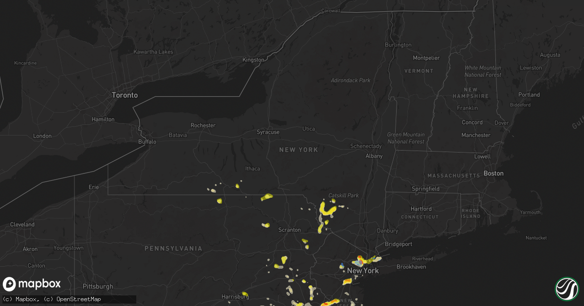
Hail Map in New York on July 6, 2020
Get this storm
July 6 map
$229
one time, instant access
Download today. No call, no setup
Keep the $229
Bought the map and want the full workflow? Apply the entire $229 to a subscription within 7 days. None of it is wasted.
Every map, not just this one
This buys you this map. Subscription and you get every map we run, in the markets you choose from a few cities to whole states to nationwide. Plus real-time alerts the moment a storm fires.
Contact data
Name, contact info, occupancy, even credit band for addresses in the footprint. You go from where it hit to who to call.
Become the source they trust
Unlimited branding weather history reports on demand. You already have the documented answer ready for the property owner, and you are the one who showed up with it.
Property data and RoofTrace estimates
Pull up any address you have got, its value and the exact code rules for that jurisdiction, straight from One Click Code. Then RoofTrace estimates the squares, pitch, and roof value, priced the way you price.
Storm reports in New York
New York
| Date | Description |
|---|---|
| 07/06/20206:06 PM CDT | Mping report |
| 07/06/20205:39 PM CDT | Swath of trees down. |
| 07/06/20205:09 PM CDT | Power lines reported down. Time is radar estimated. |
| 07/06/20205:00 PM CDT | Multiple power lines reported down and over the roadway |
| 07/06/20204:52 PM CDT | Trees down and playground equipment destroyed. Time is estimated by radar. |
| 07/06/20204:52 PM CDT | Damage reported to an rv... And house roofs |
| 07/06/20204:51 PM CDT | Dime... Half dollar and a few golf ball sized hail stones were observed. Time is estimated by radar. |
| 07/06/20204:50 PM CDT | Time estimated by radar |
| 07/06/20204:40 PM CDT | Trees and wires down marina rd |
| 07/06/20204:35 PM CDT | Very frequent quarter sized hail |
| 07/06/20204:35 PM CDT | Tree down near south ave and brickyard ln. Time estimated based on radar. |
| 07/06/20204:12 PM CDT | A local report indicates 59 MPH wind near 2 WNW LATTINGTOWN |
| 07/06/20203:55 PM CDT | Trees down. Time is estimated by radar. |
| 07/06/20202:12 AM CDT | At 712 PM EDT, a severe thunderstorm was located near Napanoch, or 7 miles north of Ellenville, moving east at 15 mph. HAZARD...60 mph wind gusts and quarter size hail. SOURCE...Radar indicated. IMPACT...Hail damage to vehicles is expected. Expect wind damage to roofs, siding, and trees. Locations impacted include... Kerhonkson, Napanoch, Wawarsing, Port Ben, Cherrytown, Liebhardt, Fantinekill, Alligerville, Lake Minnewaska, Stone Ridge, Granite, Mombaccus, Honk Hill, Mettacahonts, Mill Hook, Lackawack, Lyonsville, Accord, Potterville and Pataukunk. |
| 07/06/202012:47 AM CDT | At 547 PM EDT, severe thunderstorms were located along a line extending from near Woodbourne to Harris to Bethel, and are nearly stationary. HAZARD...60 mph wind gusts and quarter size hail. SOURCE...Radar indicated. IMPACT...Hail damage to vehicles is expected. Expect wind damage to roofs, siding, and trees. Locations impacted include... Fallsburg, Monticello, Liberty, Bethel, South Fallsburg, Woodridge, Swan Lake, Harris, Loch Sheldrake and Hurleyville. |
| 07/06/202012:35 AM CDT | At 535 PM EDT, a severe thunderstorm was located over Horseheads, or near West Elmira, moving northwest at 10 mph. HAZARD...Quarter size hail. SOURCE...Radar indicated. IMPACT...Damage to vehicles is expected. Locations impacted include... Elmira, Corning, Southport, Big Flats, Horseheads, Elmira Heights, Painted Post, South Corning, West Elmira and East Corning. |
| 07/06/202012:19 AM CDT | At 518 PM EDT, a severe thunderstorm was located over Harris, or near Liberty, and is nearly stationary. HAZARD...Quarter size hail. SOURCE...Radar indicated. IMPACT...Damage to vehicles is expected. Locations impacted include... Fallsburg, Liberty, South Fallsburg, Woodridge, Thompsonville, Harris, Loch Sheldrake, Hurleyville, Kiamesha and Woodbourne. |
| 07/06/202012:03 AM CDT | At 502 PM EDT, severe thunderstorms were located along a line extending from Throgs Neck Bridge to Sands Point to Rye, moving east at 15 mph. HAZARD...60 mph wind gusts and quarter size hail. SOURCE...Radar indicated. IMPACT...Minor hail damage to vehicles is possible. Expect wind damage to trees and power lines. Severe thunderstorms will be near... Glen Cove around 520 PM EDT. Manhasset around 525 PM EDT. Port Washington around 530 PM EDT. Bayville around 535 PM EDT. Oyster Bay and Mineola around 540 PM EDT. Huntington and Westbury around 545 PM EDT. |
| 07/05/202011:17 PM CDT | At 417 PM EDT, a severe thunderstorm was located near Woodhull, or 16 miles southwest of Corning, moving east at 25 mph. HAZARD...60 mph wind gusts and quarter size hail. SOURCE...Radar indicated. IMPACT...Hail damage to vehicles is expected. Expect wind damage to roofs, siding, and trees. Locations impacted include... Caton, Lindley, Woodhull and Lawrenceville. |
| 07/05/202010:31 PM CDT | At 331 PM EDT, a severe thunderstorm was located over Hackensack, moving southeast at 10 mph. HAZARD...60 mph wind gusts and quarter size hail. SOURCE...Radar indicated. IMPACT...Minor hail damage to vehicles is possible. Expect wind damage to trees and power lines. This severe thunderstorm will be near... Hackensack and Bergenfield around 335 PM EDT. Teterboro around 345 PM EDT. Englewood around 350 PM EDT. Ridgefield and Fort Lee around 405 PM EDT. New York and Mott Haven around 415 PM EDT. |
All States Impacted by Hail Map on July 6, 2020
Cities Impacted by Hail Map on July 6, 2020
- White Lake, WI
- Fall Creek, WI
- Augusta, WI
- Cadott, WI
- Sheboygan, WI
- Highland Park, NJ
- Iselin, NJ
- East Brunswick, NJ
- Woodbridge, NJ
- South Amboy, NJ
- Fords, NJ
- Sewaren, NJ
- Piscataway, NJ
- New Brunswick, NJ
- Avenel, NJ
- Metuchen, NJ
- Perth Amboy, NJ
- Port Reading, NJ
- Keasbey, NJ
- Sayreville, NJ
- Edison, NJ
- South Plainfield, NJ
- North Brunswick, NJ
- New Providence, PA
- Kirkwood, PA
- Nottingham, PA
- Quarryville, PA
- Peach Bottom, PA
- Malvern, PA
- Paoli, PA
- Norristown, PA
- King Of Prussia, PA
- Mont Clare, PA
- Wayne, PA
- Berwyn, PA
- Phoenixville, PA
- Oaks, PA
- Necedah, WI
- Meadow Grove, NE
- Tilden, NE
- Kimball, SD
- Cincinnati, OH
- Falmouth, KY
- Rapid City, SD
- Circle, MT
- Sloan, IA
- Shohola, PA
- Greeley, PA
- Colby, WI
- Kutztown, PA
- New Tripoli, PA
- Kempton, PA
- Fogelsville, PA
- Sherwood, MD
- Butternut, WI
- Park Falls, WI
- Bensalem, PA
- Croydon, PA
- Bordentown, NJ
- Langhorne, PA
- Burlington, NJ
- Fairless Hills, PA
- Philadelphia, PA
- Robbinsville, NJ
- Florence, NJ
- Roebling, NJ
- Levittown, PA
- Allentown, NJ
- Bristol, PA
- Riverside, NJ
- Trenton, NJ
- Chesterfield, NJ
- Morrisville, PA
- Orchard, NE
- Sundance, WY
- Harris, NY
- Ferndale, NY
- Liberty, NY
- Loch Sheldrake, NY
- Monticello, NY
- Hurleyville, NY
- Caputa, SD
- Westboro, WI
- Petersburg, NE
- Royal, NE
- Bloomfield, NE
- Lesterville, SD
- Springfield, SD
- Avon, SD
- Dixon, NE
- Elgin, NE
- Niobrara, NE
- Creighton, NE
- Waterbury, NE
- Clearwater, NE
- Newcastle, NE
- Laurel, NE
- Gayville, SD
- Utica, SD
- Saint Helena, NE
- Lindsay, NE
- Newman Grove, NE
- Irene, SD
- Tabor, SD
- Wynot, NE
- Madison, NE
- Verdigre, NE
- Tyndall, SD
- Plainview, NE
- Menno, SD
- Ponca, NE
- Neligh, NE
- Brunswick, NE
- Winnetoon, NE
- Ewing, NE
- Hartington, NE
- Yankton, SD
- Pierce, NE
- Crofton, NE
- Scotland, SD
- Vermillion, SD
- Center, NE
- Volin, SD
- Mission Hill, SD
- Ruckersville, VA
- Madison, VA
- Stanardsville, VA
- Hood, VA
- Otter, MT
- Lancaster, PA
- Newport, NJ
- Lanoka Harbor, NJ
- Bayville, NJ
- Beachwood, NJ
- Forked River, NJ
- Port Republic, NJ
- Nesquehoning, PA
- Livingston Manor, NY
- North Branch, NY
- Jeffersonville, NY
- Kenoza Lake, NY
- Callicoon, NY
- Coopersburg, PA
- Center Valley, PA
- Alexandria, SD
- Fulton, SD
- Emery, SD
- Fortescue, NJ
- Armour, SD
- Brandywine, MD
- Alexandria, VA
- Washington, DC
- Andrews Air Force Base, MD
- Upper Marlboro, MD
- District Heights, MD
- Clinton, MD
- Oxon Hill, MD
- Accokeek, MD
- Fort Washington, MD
- Suitland, MD
- Temple Hills, MD
- Aquasco, MD
- Palm City, FL
- Strasburg, PA
- Jamestown, ND
- Newberry, MI
- Parkston, SD
- Freeman, SD
- Olivet, SD
- Hulett, WY
- Hysham, MT
- New Hope, PA
- Sturgis, SD
- Sanders, MT
- Hovland, MN
- Grand Marais, MN
- Roundup, MT
- Gladstone, MI
- Rapid River, MI
- Rock, MI
- Chinook, MT
- Ringtown, PA
- Zion Grove, PA
- Hazleton, PA
- Sheppton, PA
- Barry, TX
- Orr, MN
- Milesville, SD
- Philip, SD
- Zortman, MT
- Forsyth, MT
- Grahamsville, NY
- Ellenville, NY
- Moorcroft, WY
- Mitchell, SD
- Grenloch, NJ
- Blackwood, NJ
- Hays, MT
- Deadwood, SD
- Hermosa, SD
- Scenic, SD
- Nemo, SD
- Grand Marais, MI
- Perkasie, PA
- Ottsville, PA
- New Underwood, SD
- Gore, VA
- Winchester, VA
- Turon, KS
- Cunningham, KS
- Cheltenham, PA
- Elkins Park, PA
- Wyncote, PA
- Glenside, PA
- Murdo, SD
- Weston, WY
- Petersburg, WV
- Upper Tract, WV
- Rosebud, MT
- Ewen, MI
- Athens, WI
- Weyauwega, WI
- Williamstown, KY
- Berry, KY
- Rome, PA
- Alburtis, PA
- Gilbertsville, PA
- Barto, PA
- Bechtelsville, PA
- Oley, PA
- Boyertown, PA
- Mount Sterling, KY
- Winchester, KY
- Bird In Hand, PA
- Shafer, MN
- Center City, MN
- Cody, NE
- Essex, MD
- Dundalk, MD
- New Rochelle, NY
- Port Washington, NY
- Bronx, NY
- Locust Valley, NY
- Glen Cove, NY
- Bowie, MD
- Eubank, KY
- La Plata, MD
- Hughesville, MD
- Charlotte Hall, MD
- Parksville, NY
- Ronks, PA
- Willow Street, PA
- Thedford, NE
- Valentine, NE
- Munising, MI
- Shingleton, MI
- Arkdale, WI
- Cleveland, WI
- Jackson, MN
- Veedersburg, IN
- Loyal, WI
- Stapleton, NE
- Arnold, NE
- Clay City, KY
- Richey, MT
- Wood Ridge, NJ
- Carlstadt, NJ
- Teterboro, NJ
- Moonachie, NJ
- Hasbrouck Heights, NJ
- Passaic, NJ
- Rochelle Park, NJ
- Ridgefield Park, NJ
- Paramus, NJ
- Saddle Brook, NJ
- Ridgefield, NJ
- East Rutherford, NJ
- Lodi, NJ
- Secaucus, NJ
- Maywood, NJ
- Hackensack, NJ
- Wallington, NJ
- South Hackensack, NJ
- Fair Lawn, NJ
- Little Ferry, NJ
- Glasgow, MT
- Lemmon, SD
- Clarks Hill, IN
- Frankfort, IN
- Tripp, SD
- Bangor, WI
- Hunter, ND
- Arthur, ND
- West Chester, PA
- Downingtown, PA
- Kennett Square, PA
- Chadds Ford, PA
- Mount Vernon, NY
- Bronxville, NY
- Blooming Grove, TX
- Lumberton, NJ
- Mount Laurel, NJ
- Marlton, NJ
- Medford, NJ
- Osceola, NE
- Monroe, NE
- Shelby, NE
- Columbus, NE
- Platte Center, NE
- Rising City, NE
- Bellwood, NE
- Duncan, NE
- Chalfont, PA
- Horsham, PA
- North Wales, PA
- Ambler, PA
- Warrington, PA
- Stevens, PA
- Denver, PA
- Ephrata, PA
- Sardinia, OH
- Capitol Heights, MD
- Elk Horn, KY
- Volborg, MT
- Corinth, KY
- Cornell, MI
- Madison, SD
- Weatherly, PA
- Jim Thorpe, PA
- Musselshell, MT
- Barnard, KS
- Lincoln, KS
- Big Falls, MN
- Wilmington, OH
- Melbourne, KY
- Newport, KY
- Silver Grove, KY
- New Holland, SD
- Corsica, SD
- Harrison, SD
- Platte, SD
- Geddes, SD
- White Lake, SD
- Delmont, SD
- Stickney, SD
- Fordyce, NE
- Wynnewood, PA
- Bala Cynwyd, PA
- Narberth, PA
- Ardmore, PA
- Merion Station, PA
- Spring City, PA
- Devon, PA
- Collegeville, PA
- Lafayette, IN
- Andover, MN
- Green Lake, WI
- Saint Croix Falls, WI
- Dresser, WI
- Tioga, PA
- Middlebury Center, PA
- Campbell, NY
- Summit Hill, PA
- Staten Island, NY
- Glenn Dale, MD
- Sparrows Point, MD
- Middle River, MD
- White Marsh, MD
- Lead, SD
- Ramona, SD
- Winter, WI
- Mount Vernon, KY
- Orlando, KY
- Lake Linden, MI
- Lakeview, OH
- Wapakoneta, OH
- Elmira, NY
- Horseheads, NY
- Sudlersville, MD
- Somers Point, NJ
- Malta, MT
- Mays Landing, NJ
- Lyndhurst, VA
- Stuarts Draft, VA
- Stephenson, MI
- Reliance, SD
- New Lisbon, WI
- Mauston, WI
- Sayre, PA
- Louisville, KY
- Owanka, SD
- Little Meadows, PA
- Warren Center, PA
- Owen, WI
- Winfred, SD
- Northampton, PA
- Markesan, WI
- Newark, DE
- Chester Springs, PA
- Exton, PA
- Royersford, PA
- Pottstown, PA
- Glenmoore, PA
- Nekoosa, WI
- South Windsor, CT
- Broad Brook, CT
- East Windsor, CT
- Johnstown, NE
- Woodhull, NY
- Addison, NY
- Allentown, PA
- Whitehall, PA
- Lynchburg, OH
- Hillsboro, OH
- Lloyd, MT
- Allen, SD
- Morristown, NJ
- Egg Harbor City, NJ
- Hammonton, NJ
- Spearfish, SD
- Bridgeton, NJ
- Millville, NJ
- Cresco, PA
- Kearneysville, WV
- Caneyville, KY
- Laurel, MD
- Bladensburg, MD
- Lanham, MD
- Hyattsville, MD
- Beltsville, MD
- College Park, MD
- Greenbelt, MD
- Riverdale, MD
- Irvine, KY
- Beloit, KS
- Worton, MD
- Lake Tomahawk, WI
- Rhinelander, WI
- Gillette, NJ
- Chatham, NJ
- New Providence, NJ
- Berkeley Heights, NJ
- Valley Head, WV
- Pound, WI
- Thorofare, NJ
- Paulsboro, NJ
- Mantua, NJ
- Wenonah, NJ
- Woodbury Heights, NJ
- Woodbury, NJ
- Sewell, NJ
- Dushore, PA
- Belfry, KY
- Williamson, WV
- South Williamson, KY
- Waldorf, MD
- Bryantown, MD
- Paragon, IN
- Nenzel, NE
- Kilgore, NE
- Centuria, WI
- Luck, WI
- Taylors Falls, MN
- Littlefork, MN
- Ely, MN
- Ellettsville, IN
- Sioux City, IA
- Potter, NE
- Jackson, NJ
- Howell, NJ
- Lakewood, NJ
- Milltown, WI
- Cushing, WI
- White River, SD
- Sparta, WI
- Crandon, WI
- Mahanoy City, PA
- Shenandoah, PA
- Richland, MT
- Larslan, MT
- Hummelstown, PA
- Hershey, PA
- Martinsville, IN
- Woodbourne, NY
- White Lake, NY
- Smallwood, NY
- Mongaup Valley, NY
- Cochecton, NY
- Roscoe, NY
- South Fallsburg, NY
- Bethel, NY
- Swan Lake, NY
- Youngsville, NY
- Long Pine, NE
- Bassett, NE
- Wagner, SD
- Black River Falls, WI
- Bethlehem, PA
- Hellertown, PA
- Richlandtown, PA
- Quakertown, PA
- Burnett, WI
- Hancock, WI
- Englewood Cliffs, NJ
- Fort Lee, NJ
- Rockland, WI
- Cashton, WI
- West Salem, WI
- La Crosse, WI
- Warwick, MD
- Chesapeake City, MD
- Jessup, MD
- Severn, MD
- Fort George G Meade, MD
- Hanover, MD
- Portage, WI
- Custer, MT
- Worden, MT
- Midland, SD
- Franklinville, NJ
- Chassell, MI
- Chilton, WI
- White Plains, MD
- Kermit, WV
- Crum, WV
- Camden, TN
- Holladay, TN
- Cameron Mills, NY
- Bear, DE
- Elkton, MD
- Glen Spey, NY
- Highland Lake, NY
- Perkins, MI
- Escanaba, MI
- Wilson, MI
- Bark River, MI
- Mehoopany, PA
- Peerless, MT
- Vida, MT
- South Charleston, OH
- Farmingdale, NJ
- Oakdale, NE
- Vincentown, NJ
- Mount Holly, NJ
- Columbus, NJ
- Pemberton, NJ
- Jobstown, NJ
- Whitewood, SD
- Broadus, MT
- Tomahawk, WI
- Howard, SD
- Genoa, NE
- Quinwood, WV
- Bergland, MI
- Englishtown, NJ
- Ranson, WV
- Charles Town, WV
- Shenandoah Junction, WV
- Rosemount, MN
- Hill City, SD
- Pine Ridge, SD
- Kyle, SD
- Gambrills, MD
- North East, MD
- Rising Sun, MD
- Stevensville, MD
- Reedsville, WI
- Callaway, NE
- Lower Brule, SD
- Amasa, MI
- Whitewater, MT
- Ethan, SD
- Gleason, WI
- Campton, KY
- Milltown, NJ
- Henryville, PA
- Liberty, KY
- Science Hill, KY
- Bethelridge, KY
- Saint Edward, NE
- Slatedale, PA
- Slatington, PA
- New Holland, PA
- Gap, PA
- East Earl, PA
- Narvon, PA
- Stratford, NJ
- Cherry Hill, NJ
- Somerdale, NJ
- Moorestown, NJ
- Maple Shade, NJ
- Haddonfield, NJ
- Lawnside, NJ
- Voorhees, NJ
- Hainesport, NJ
- Clementon, NJ
- Gibbsboro, NJ
- Eldred, NY
- Brodhead, KY
- Belvidere, SD
- Long Valley, SD
- Tobyhanna, PA
- Kiel, WI
- Wellington, KY
- Crivitz, WI
- Kaylor, SD
- Ainsworth, NE
- Purdon, TX
- Eagle River, WI
- Stoneham, CO
- Brush, CO
- Burwell, NE
- McKee, KY
- Corsicana, TX
- Burke, SD
- Annapolis, MD
- Italy, TX
- Windsor, CT
- Cedar, MN
- Wilson, KS
- Brick, NJ
- Osceola, WI
- Alva, WY
- Williamstown, NJ
- The Villages, FL
- Leola, PA
- Fort Meade, SD
- Douglassville, PA
- Wrightstown, NJ
- Cream Ridge, NJ
- Greenwood, WI
- Taylor, NE
- Leonia, NJ
- Englewood, NJ
- Clifton, NJ
- Verona, NJ
- New York, NY
- Teaneck, NJ
- Nutley, NJ
- Garfield, NJ
- Bloomfield, NJ
- Elmwood Park, NJ
- North Bergen, NJ
- Cedar Grove, NJ
- Rutherford, NJ
- Montclair, NJ
- Bogota, NJ
- Edgewater, NJ
- Palisades Park, NJ
- Fountainville, PA
- Doylestown, PA
- Sidney, NE
- Cayuta, NY
- River Edge, NJ
- Fairview, NJ
- West New York, NJ
- Summit Point, WV
- Middletown, DE
- Frankston, TX
- Bullard, TX
- Daggett, MI
- Coleman, WI
- Lake Wilson, MN
- Troupsburg, NY
- Hot Springs, VA
- Trenary, MI
- Chatham, MI
- Pardeeville, WI
- Bunker Hill, WV
- Monroe Township, NJ
- Pipersville, PA
- Dublin, PA
- Ewing, KY
- Andreas, PA
- Tamaqua, PA
- Lehighton, PA
- New Ringgold, PA
- Crookston, NE
- Fallsburg, NY
- Pleasant Mount, PA
- Amery, WI
- Cartwright, ND
- Hortonville, WI
- Holmen, WI
- Mindoro, WI
- Valders, WI
- La Farge, WI
- Haverford, PA
- Lafayette Hill, PA
- Beverly, NJ
- Blue Bell, PA
- Plymouth Meeting, PA
- Conshohocken, PA
- Havertown, PA
- Fort Washington, PA
- Jenkintown, PA
- Oreland, PA
- Flourtown, PA
- Palmyra, NJ
- Dalton, WI
- Montello, WI
- Lisco, NE
- Cochranville, PA
- Atglen, PA
- Lyons, CO
- Pukwana, SD
- Lavina, MT
- Marenisco, MI
- Toms River, NJ
- Lakehurst, NJ
- Manchester Township, NJ
- Freehold, NJ
- Warm Springs, VA
- Plymouth, WI
- Sheboygan Falls, WI
- Sadieville, KY
- Draper, SD
- Baltimore, MD
- Rosedale, MD
- Millwood, KY
- Cook, MN
- Millersville, MD
- Crownsville, MD
- Jackson, KY
- Cedarville, NJ
- Clear Brook, VA
- Gerrardstown, WV
- Willard, WI
- Valley Mills, TX
- Dry Ridge, KY
- Mescalero, NM
- Heron Lake, MN
- Sicklerville, NJ
- Vale, SD
- Melrose, WI
- Oshkosh, NE
- Whiting, IA
- Stephenson, VA
- Belle Fourche, SD
- Manasquan, NJ
- Sea Girt, NJ
- Brielle, NJ
- Fort Thomas, KY
- Pearson, WI
- Fond Du Lac, WI
- Hillsboro, WI
- South Solon, OH
- Nancy, KY
- Russell Springs, KY
- Port Saint Lucie, FL
- Fort Pierce, FL
- Schuylkill Haven, PA
- Pottsville, PA
- Centreville, MD
- Chestertown, MD
- Bethel, OH
- Mount Orab, OH
- Frost, TX
- Basking Ridge, NJ
- Madison, NJ
- Green Village, NJ
- New Vernon, NJ
- Kadoka, SD
- Mertztown, PA
- Breinigsville, PA
- Macungie, PA
- Trexlertown, PA
- Interior, SD
- Caldwell, NJ
- Lyndhurst, NJ
- Glen Ridge, NJ
- Cliffside Park, NJ
- Little Falls, NJ
- Belleville, NJ
- North Arlington, NJ
- Mechanicsburg, PA
- Crab Orchard, KY
- Waterford Works, NJ
- Atco, NJ
- Berlin, NJ
- Sapello, NM
- Ogema, WI
- Okaton, SD
- Equinunk, PA
- London, KY
- Wyoming, MN
- Wibaux, MT
- Pequea, PA
- Conestoga, PA
- Mount Olivet, KY
- White Sulphur Springs, WV
- Barryville, NY
- Hubbard, NE
- Union, KY
- Chisago City, MN
- Wood Lake, NE
- Kerhonkson, NY
- Yulan, NY
- Lackawaxen, PA
- Hawley, PA
- Milford, PA
- Narrowsburg, NY
- Huntsville, OH
- Milford, OH
- Batavia, OH
- Kintnersville, PA
- Absecon, NJ
- Chatsworth, NJ
- Saint Paul, MN
- Glassboro, NJ
- Goshen, OH
- Loveland, OH
- Ponderosa, NM
- Jemez Springs, NM
- Spooner, WI
- Monrovia, IN
- Quincy, IN
- Pelican Lake, WI
- Ribera, NM
- Pecos, NM
- Dayton, MN
- Carney, MI
- Glen Burnie, MD
- Pasadena, MD
- Windsor, KY
- Ocean View, NJ
- Marmora, NJ
- Egg Harbor Township, NJ
- Woodbine, NJ
- Ocean City, NJ
- Leota, MN
- Jewell, KS
- Buena, NJ
- Harrisburg, PA
- Brooklyn, NY
- Chappell, NE
- Christiana, PA
- Ontonagon, MI
- Bruce Crossing, MI
- Watersmeet, MI
- Oxford, PA
- Smoketown, PA
- Lititz, PA
- East Petersburg, PA
- Saint Marie, MT
- Opheim, MT
- Plevna, MT
- Baker, MT
- Ismay, MT
- Newell, SD
- Alzada, MT
- Naper, NE
- Gregory, SD
- Winner, SD
- White Owl, SD
- Oneill, NE
- Ideal, SD
- Wood, SD
- Saint Charles, SD
- Lake Andes, SD
- Kennebec, SD
- Bristow, NE
- Fort Pierre, SD
- Okreek, SD
- Wanblee, SD
- Quinn, SD
- Mission, SD
- Vivian, SD
- Cherry Creek, SD
- Page, NE
- Wasta, SD
- Wall, SD
- Fairfax, SD
- Lynch, NE
- Bonesteel, SD
- Hamill, SD
- Mills, NE
- Dallas, SD
- Stuart, NE
- Butte, NE
- Norris, SD
- Hayes, SD
- Pickstown, SD
- Howes, SD
- Spencer, NE
- Herrick, SD
- Oacoma, SD
- Chamberlain, SD
- Witten, SD
- Presho, SD
- Atkinson, NE
- Colome, SD
- Pierre, SD
- Jackson, NE
- Jefferson, SD
- North Sioux City, SD
- Devils Tower, WY
- Cedar Knolls, NJ
- Morris Plains, NJ
- Whippany, NJ
- Mamaroneck, NY
- Larchmont, NY
- Hightstown, NJ
- Newfoundland, PA
- Canadensis, PA
- Apalachin, NY
- Friendsville, PA
- Vestal, NY
- Brackney, PA
- Lawrenceville, PA
- New Milford, NJ
- Bergenfield, NJ
- Florham Park, NJ
- Ridgewood, NJ
- Oradell, NJ
- Glen Rock, NJ
- Yonkers, NY
- Pelham, NY
- Barnesville, PA
- Palmyra, PA
- Vernon Rockville, CT
- Ellington, CT
- Naval Anacost Annex, DC
- Arlington, VA
- Harwood, MD
- Davidsonville, MD
- Odenton, MD
- Severna Park, MD
- Greenwood, DE
- Houston, DE
- Rock Hall, MD
- Barclay, MD
- Church Hill, MD
- Denton, MD
- Marydel, MD
- Ridgely, MD
- Henderson, MD
- Queen Anne, MD
- Greensboro, MD
- Harrington, DE
- Lincoln, DE
- Goldsboro, MD
- Felton, DE
- Bridgeville, DE
- Seaford, DE


