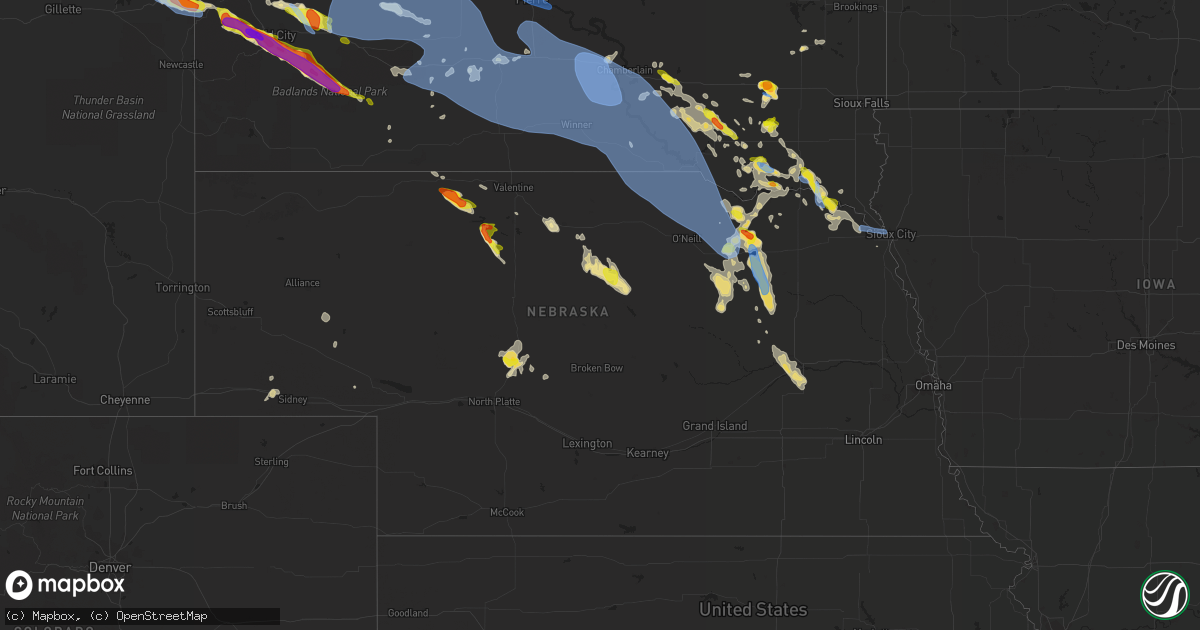
Hail Map in Nebraska on July 6, 2020
Get this storm
July 6 map
$229
one time, instant access
Download today. No call, no setup
Keep the $229
Bought the map and want the full workflow? Apply the entire $229 to a subscription within 7 days. None of it is wasted.
Every map, not just this one
This buys you this map. Subscription and you get every map we run, in the markets you choose from a few cities to whole states to nationwide. Plus real-time alerts the moment a storm fires.
Contact data
Name, contact info, occupancy, even credit band for addresses in the footprint. You go from where it hit to who to call.
Become the source they trust
Unlimited branding weather history reports on demand. You already have the documented answer ready for the property owner, and you are the one who showed up with it.
Property data and RoofTrace estimates
Pull up any address you have got, its value and the exact code rules for that jurisdiction, straight from One Click Code. Then RoofTrace estimates the squares, pitch, and roof value, priced the way you price.
Storm reports in Nebraska
Nebraska
| Date | Description |
|---|---|
| 07/06/20206:52 PM CDT | The wind was strong enough to move a trailer. There were also several limbs broken off of a tree. |
| 07/06/20206:49 PM CDT | A local report indicates 1.50 inch wind near 11 SE ELI |
| 07/06/20206:40 PM CDT | A local report indicates 60 MPH wind near 4 ENE BRUNSWICK |
| 07/06/20206:34 PM CDT | Penny-sized hail and heavy rain in addition to the strong winds. |
| 07/06/20206:28 PM CDT | A local report indicates 67 MPH wind near 1 W PONCA |
| 07/06/20206:10 PM CDT | A local report indicates 1.50 inch wind near 1 W CREIGHTON |
| 07/06/20205:51 PM CDT | Some pea sized hail also. |
| 07/06/20205:36 PM CDT | Trained spotter estimated wind at about 60 mph. |
| 07/06/20205:25 PM CDT | A local report indicates 1.00 inch wind near 1 ESE CREIGHTON |
| 07/06/20205:24 PM CDT | Public reported golf ball sized hail in creighton. |
| 07/06/20205:22 PM CDT | Report from mping: ping pong ball |
| 07/06/20206:42 AM CDT | At 1142 PM CDT, a severe thunderstorm was located 7 miles southeast of Ringgold, or 8 miles west of Stapleton, moving east at 20 mph. HAZARD...60 mph wind gusts and quarter size hail. SOURCE...Radar indicated. IMPACT...Hail damage to vehicles is expected. Expect wind damage to roofs, siding, and trees. Locations impacted include... Stapleton and Gandy. This includes the following highways... Highway 92 between mile markers 219 and 246. Highway 83 between mile markers 100 and 114. |
| 07/06/20205:14 AM CDT | At 1011 PM MDT/1111 PM CDT/, severe thunderstorms were located along a line extending from 3 miles southeast of Okaton to 4 miles southeast of Swett, moving southeast at 35 mph. HAZARD...70 mph wind gusts and quarter size hail. SOURCE...Radar indicated. IMPACT...Hail damage to vehicles is expected. Expect considerable tree damage. Wind damage is also likely to mobile homes, roofs, and outbuildings. Severe thunderstorms will be near... Lacreek Wildlife Refuge and White River around 1130 PM CDT. Saint Francis, Mission, and Wood around 1205 AM CDT. |
| 07/06/20204:53 AM CDT | At 952 PM CDT, severe thunderstorms were located along a line extending from 10 miles northeast of Rose to 16 miles north of Brewster, moving southeast at 25 mph. HAZARD...60 mph wind gusts and quarter size hail. SOURCE...Radar indicated. IMPACT...Hail damage to vehicles is expected. Expect wind damage to roofs, siding, and trees. Locations impacted include... Rose, Fox Bayou, Duff, Almeria Meadow State Wildlife Management Area, Horseshoe Bend Lake, Johnsons Corner and Carson Lake.This includes Highway 183 between mile markers 135 and 162. |
| 07/06/20203:17 AM CDT | At 817 PM CDT, severe thunderstorms were located along a line extending from near Johnstown to near Valentine National Wildlife Refuge, moving southeast at 20 mph. HAZARD...60 mph wind gusts and quarter size hail. SOURCE...Radar indicated. IMPACT...Hail damage to vehicles is expected. Expect wind damage to roofs, siding, and trees. Locations impacted include... Ainsworth, Johnstown, Elsmere, Valentine National Wildlife Refuge, Wood Lake, Hofeld Lake, Moon Lake, Willow Lake State Wildlife Management Area and Long Lake State Wildlife Management Area.This includes the following highways... Highway 20 between mile markers 218 and 244. Highway 83 between mile markers 183 and 193. |
| 07/06/20203:12 AM CDT | At 812 PM CDT, severe thunderstorms were located along a line extending from 7 miles south of Meadow Grove to 6 miles west of Elgin, moving south at 20 mph. HAZARD...60 mph wind gusts and quarter size hail. SOURCE...Radar indicated. IMPACT...Hail damage to vehicles is expected. Expect wind damage to roofs, siding, and trees. Locations impacted include... Madison, Battle Creek, Newman Grove, Elgin, Petersburg, Oakdale, Meadow Grove, Lindsay, Tilden and Loretto. |
| 07/06/20202:55 AM CDT | At 754 PM CDT/654 PM MDT/, a severe thunderstorm was located 11 miles south of Merritt Reservoir, or 29 miles southwest of Valentine, moving southeast at 35 mph. HAZARD...Golf ball size hail and 60 mph wind gusts. SOURCE...Radar indicated. IMPACT...People and animals outdoors will be injured. Expect hail damage to roofs, siding, windows, and vehicles. Expect wind damage to roofs, siding, and trees. Locations impacted include... Brownlee, Highway 83 crossing Goose Creek and Highway 83 crossing the North Loup River.This includes the following highways... Highway 97 between mile markers 100 and 106. Highway 83 between mile markers 158 and 182. |
| 07/06/20202:38 AM CDT | At 737 PM MDT, severe thunderstorms were located along a line extending from 8 miles east of Antioch to near Crescent Lake National Wildlife Refuge to 18 miles northeast of Lisco to 7 miles southwest of Oshkosh, moving east at 30 mph. HAZARD...60 mph wind gusts and nickel size hail. SOURCE...Radar indicated. IMPACT...Expect damage to roofs, siding, and trees. Locations impacted include... Oshkosh, Ellsworth, Lewellen, Ashby, Antioch, Crescent Lake National Wildlife Refuge, Dogtown Flats, Swede Lake, Deer Lake, Britton Lake, Mumper, Bourquim Hill, Herman Lake, Adams Flats, Sugar Loaf Hill, Eagle Gulch Campground, Ruthon, Clear Creek State Wildlife Management Area, Rackett and Patterson Lake.This includes the following highways... Highway 250 between mile markers 1 and 7. Highway 2 between mile markers 100 and 139. Highway 92 between mile markers 115 and 130. |
| 07/06/20202:20 AM CDT | At 719 PM CDT, a severe thunderstorm was located 10 miles north of Meadow Grove, or 21 miles northwest of Norfolk, moving southeast at 20 mph. HAZARD...60 mph wind gusts and quarter size hail. SOURCE...Radar indicated. IMPACT...Hail damage to vehicles is expected. Expect wind damage to roofs, siding, and trees. Locations impacted include... Norfolk, Pierce, Neligh, Battle Creek, Elgin, Clearwater, Oakdale, Meadow Grove, Hadar, Tilden and Willow Creek State Recreation Area. |
| 07/06/20201:43 AM CDT | Tree limbs downed. |
| 07/06/20201:42 AM CDT | At 642 PM CDT, severe thunderstorms were located along a line extending from Plainview to 10 miles north of Neligh to Orchard, moving southeast at 10 mph. HAZARD...Ping pong ball size hail and 60 mph wind gusts. SOURCE...Radar indicated. IMPACT...People and animals outdoors will be injured. Expect hail damage to roofs, siding, windows, and vehicles. Expect wind damage to roofs, siding, and trees. Locations impacted include... Osmond, Clearwater, Orchard, Brunswick, Royal, Foster, McLean and The Highway 81 And 20 Junction. |
| 07/06/20201:14 AM CDT | At 613 PM CDT, a severe thunderstorm was located over Creighton, or 34 miles southwest of Lewis And Clark State Recreation Area, moving southeast at 10 mph. HAZARD...60 mph wind gusts and half dollar size hail. SOURCE...Radar indicated. IMPACT...Hail damage to vehicles is expected. Expect wind damage to roofs, siding, and trees. Locations impacted include... Plainview, Creighton, Winnetoon and Bazile Mills. |
| 07/06/202012:59 AM CDT | At 559 PM CDT, a severe thunderstorm was located near Orchard, or 22 miles east of O'neill, moving northeast at 10 mph. HAZARD...Golf ball size hail and 60 mph wind gusts. SOURCE...Radar indicated. IMPACT...People and animals outdoors will be injured. Expect hail damage to roofs, siding, windows, and vehicles. Expect wind damage to roofs, siding, and trees. Locations impacted include... Orchard and Ashfall Fossil Beds State Historical Park. |
| 07/06/202012:52 AM CDT | At 551 PM CDT, a severe thunderstorm was located west of Creighton, or 33 miles east of O'neill, moving east at 10 mph. HAZARD...60 mph wind gusts and quarter size hail. SOURCE...Radar indicated. IMPACT...Hail damage to vehicles is expected. Expect wind damage to roofs, siding, and trees. Locations impacted include... Creighton, Winnetoon, Bazile Mills and The Highway 14 And 59 Junction. |
| 07/06/202012:42 AM CDT | At 542 PM CDT, a severe thunderstorm was located near Verdigre, or 26 miles southwest of Tyndall, moving east at 10 mph. HAZARD...Ping pong ball size hail and 60 mph wind gusts. SOURCE...Radar indicated. IMPACT...People and animals outdoors will be injured. Expect hail damage to roofs, siding, windows, and vehicles. Expect wind damage to roofs, siding, and trees. Locations impacted include... Verdigre and Center. |
| 07/06/202012:12 AM CDT | At 512 PM CDT, a severe thunderstorm was located near Creighton, or 36 miles east of O'neill, moving east at 10 mph. HAZARD...60 mph wind gusts and quarter size hail. SOURCE...Radar indicated. IMPACT...Hail damage to vehicles is expected. Expect wind damage to roofs, siding, and trees. Locations impacted include... Plainview, Creighton, Winnetoon and Bazile Mills. |
| 07/05/202011:38 PM CDT | At 436 PM CDT, a severe thunderstorm was located near Mayfield, or 9 miles north of Yankton, moving east at 10 mph. HAZARD...60 mph wind gusts and quarter size hail. SOURCE...Radar indicated. IMPACT...Hail damage to vehicles is expected. Expect wind damage to roofs, siding, and trees. This severe thunderstorm will be near... Mayfield around 445 PM CDT. Lesterville around 450 pm CDT Mission Hill around 505 PM CDT. Volin around 515 PM CDT.Other locations impacted by this severe thunderstorm includeGayville, Lesterville and St. Helena Boat Dock. |
| 07/05/20209:17 PM CDT | A local report indicates 60 MPH wind near 5 SW BINGHAM |
| 07/05/20208:55 PM CDT | Measured on a personal weather sensor. |
| 07/05/20208:42 PM CDT | Numerous large limbs down around lindsay. |
| 07/05/20208:32 PM CDT | Trees broken off. Numerous limbs down across town. |
| 07/05/20208:17 PM CDT | Estimated 60 to 70 mph gusts. |
| 07/05/20207:57 PM CDT | Lawn furniture blown around. Small branches broken. |
| 07/05/20207:46 PM CDT | Significant damage to a hog barn with partial roof removal. Corn plants flattened by wind. 2 miles east of this location had crop fields completely stripped of leaves d |
| 07/05/20207:39 PM CDT | Trees and limbs down in tilden. Accompanied by dime size hail. Neighbor measured 64 mph on personal weather station. |
| 07/05/20207:00 PM CDT | A local report indicates 1.75 inch wind near 9 SSW NENZEL |
All States Impacted by Hail Map on July 6, 2020
Cities Impacted by Hail Map on July 6, 2020
- White Lake, WI
- Fall Creek, WI
- Augusta, WI
- Cadott, WI
- Sheboygan, WI
- Highland Park, NJ
- Iselin, NJ
- East Brunswick, NJ
- Woodbridge, NJ
- South Amboy, NJ
- Fords, NJ
- Sewaren, NJ
- Piscataway, NJ
- New Brunswick, NJ
- Avenel, NJ
- Metuchen, NJ
- Perth Amboy, NJ
- Port Reading, NJ
- Keasbey, NJ
- Sayreville, NJ
- Edison, NJ
- South Plainfield, NJ
- North Brunswick, NJ
- New Providence, PA
- Kirkwood, PA
- Nottingham, PA
- Quarryville, PA
- Peach Bottom, PA
- Malvern, PA
- Paoli, PA
- Norristown, PA
- King Of Prussia, PA
- Mont Clare, PA
- Wayne, PA
- Berwyn, PA
- Phoenixville, PA
- Oaks, PA
- Necedah, WI
- Meadow Grove, NE
- Tilden, NE
- Kimball, SD
- Cincinnati, OH
- Falmouth, KY
- Rapid City, SD
- Circle, MT
- Sloan, IA
- Shohola, PA
- Greeley, PA
- Colby, WI
- Kutztown, PA
- New Tripoli, PA
- Kempton, PA
- Fogelsville, PA
- Sherwood, MD
- Butternut, WI
- Park Falls, WI
- Bensalem, PA
- Croydon, PA
- Bordentown, NJ
- Langhorne, PA
- Burlington, NJ
- Fairless Hills, PA
- Philadelphia, PA
- Robbinsville, NJ
- Florence, NJ
- Roebling, NJ
- Levittown, PA
- Allentown, NJ
- Bristol, PA
- Riverside, NJ
- Trenton, NJ
- Chesterfield, NJ
- Morrisville, PA
- Orchard, NE
- Sundance, WY
- Harris, NY
- Ferndale, NY
- Liberty, NY
- Loch Sheldrake, NY
- Monticello, NY
- Hurleyville, NY
- Caputa, SD
- Westboro, WI
- Petersburg, NE
- Royal, NE
- Bloomfield, NE
- Lesterville, SD
- Springfield, SD
- Avon, SD
- Dixon, NE
- Elgin, NE
- Niobrara, NE
- Creighton, NE
- Waterbury, NE
- Clearwater, NE
- Newcastle, NE
- Laurel, NE
- Gayville, SD
- Utica, SD
- Saint Helena, NE
- Lindsay, NE
- Newman Grove, NE
- Irene, SD
- Tabor, SD
- Wynot, NE
- Madison, NE
- Verdigre, NE
- Tyndall, SD
- Plainview, NE
- Menno, SD
- Ponca, NE
- Neligh, NE
- Brunswick, NE
- Winnetoon, NE
- Ewing, NE
- Hartington, NE
- Yankton, SD
- Pierce, NE
- Crofton, NE
- Scotland, SD
- Vermillion, SD
- Center, NE
- Volin, SD
- Mission Hill, SD
- Ruckersville, VA
- Madison, VA
- Stanardsville, VA
- Hood, VA
- Otter, MT
- Lancaster, PA
- Newport, NJ
- Lanoka Harbor, NJ
- Bayville, NJ
- Beachwood, NJ
- Forked River, NJ
- Port Republic, NJ
- Nesquehoning, PA
- Livingston Manor, NY
- North Branch, NY
- Jeffersonville, NY
- Kenoza Lake, NY
- Callicoon, NY
- Coopersburg, PA
- Center Valley, PA
- Alexandria, SD
- Fulton, SD
- Emery, SD
- Fortescue, NJ
- Armour, SD
- Brandywine, MD
- Alexandria, VA
- Washington, DC
- Andrews Air Force Base, MD
- Upper Marlboro, MD
- District Heights, MD
- Clinton, MD
- Oxon Hill, MD
- Accokeek, MD
- Fort Washington, MD
- Suitland, MD
- Temple Hills, MD
- Aquasco, MD
- Palm City, FL
- Strasburg, PA
- Jamestown, ND
- Newberry, MI
- Parkston, SD
- Freeman, SD
- Olivet, SD
- Hulett, WY
- Hysham, MT
- New Hope, PA
- Sturgis, SD
- Sanders, MT
- Hovland, MN
- Grand Marais, MN
- Roundup, MT
- Gladstone, MI
- Rapid River, MI
- Rock, MI
- Chinook, MT
- Ringtown, PA
- Zion Grove, PA
- Hazleton, PA
- Sheppton, PA
- Barry, TX
- Orr, MN
- Milesville, SD
- Philip, SD
- Zortman, MT
- Forsyth, MT
- Grahamsville, NY
- Ellenville, NY
- Moorcroft, WY
- Mitchell, SD
- Grenloch, NJ
- Blackwood, NJ
- Hays, MT
- Deadwood, SD
- Hermosa, SD
- Scenic, SD
- Nemo, SD
- Grand Marais, MI
- Perkasie, PA
- Ottsville, PA
- New Underwood, SD
- Gore, VA
- Winchester, VA
- Turon, KS
- Cunningham, KS
- Cheltenham, PA
- Elkins Park, PA
- Wyncote, PA
- Glenside, PA
- Murdo, SD
- Weston, WY
- Petersburg, WV
- Upper Tract, WV
- Rosebud, MT
- Ewen, MI
- Athens, WI
- Weyauwega, WI
- Williamstown, KY
- Berry, KY
- Rome, PA
- Alburtis, PA
- Gilbertsville, PA
- Barto, PA
- Bechtelsville, PA
- Oley, PA
- Boyertown, PA
- Mount Sterling, KY
- Winchester, KY
- Bird In Hand, PA
- Shafer, MN
- Center City, MN
- Cody, NE
- Essex, MD
- Dundalk, MD
- New Rochelle, NY
- Port Washington, NY
- Bronx, NY
- Locust Valley, NY
- Glen Cove, NY
- Bowie, MD
- Eubank, KY
- La Plata, MD
- Hughesville, MD
- Charlotte Hall, MD
- Parksville, NY
- Ronks, PA
- Willow Street, PA
- Thedford, NE
- Valentine, NE
- Munising, MI
- Shingleton, MI
- Arkdale, WI
- Cleveland, WI
- Jackson, MN
- Veedersburg, IN
- Loyal, WI
- Stapleton, NE
- Arnold, NE
- Clay City, KY
- Richey, MT
- Wood Ridge, NJ
- Carlstadt, NJ
- Teterboro, NJ
- Moonachie, NJ
- Hasbrouck Heights, NJ
- Passaic, NJ
- Rochelle Park, NJ
- Ridgefield Park, NJ
- Paramus, NJ
- Saddle Brook, NJ
- Ridgefield, NJ
- East Rutherford, NJ
- Lodi, NJ
- Secaucus, NJ
- Maywood, NJ
- Hackensack, NJ
- Wallington, NJ
- South Hackensack, NJ
- Fair Lawn, NJ
- Little Ferry, NJ
- Glasgow, MT
- Lemmon, SD
- Clarks Hill, IN
- Frankfort, IN
- Tripp, SD
- Bangor, WI
- Hunter, ND
- Arthur, ND
- West Chester, PA
- Downingtown, PA
- Kennett Square, PA
- Chadds Ford, PA
- Mount Vernon, NY
- Bronxville, NY
- Blooming Grove, TX
- Lumberton, NJ
- Mount Laurel, NJ
- Marlton, NJ
- Medford, NJ
- Osceola, NE
- Monroe, NE
- Shelby, NE
- Columbus, NE
- Platte Center, NE
- Rising City, NE
- Bellwood, NE
- Duncan, NE
- Chalfont, PA
- Horsham, PA
- North Wales, PA
- Ambler, PA
- Warrington, PA
- Stevens, PA
- Denver, PA
- Ephrata, PA
- Sardinia, OH
- Capitol Heights, MD
- Elk Horn, KY
- Volborg, MT
- Corinth, KY
- Cornell, MI
- Madison, SD
- Weatherly, PA
- Jim Thorpe, PA
- Musselshell, MT
- Barnard, KS
- Lincoln, KS
- Big Falls, MN
- Wilmington, OH
- Melbourne, KY
- Newport, KY
- Silver Grove, KY
- New Holland, SD
- Corsica, SD
- Harrison, SD
- Platte, SD
- Geddes, SD
- White Lake, SD
- Delmont, SD
- Stickney, SD
- Fordyce, NE
- Wynnewood, PA
- Bala Cynwyd, PA
- Narberth, PA
- Ardmore, PA
- Merion Station, PA
- Spring City, PA
- Devon, PA
- Collegeville, PA
- Lafayette, IN
- Andover, MN
- Green Lake, WI
- Saint Croix Falls, WI
- Dresser, WI
- Tioga, PA
- Middlebury Center, PA
- Campbell, NY
- Summit Hill, PA
- Staten Island, NY
- Glenn Dale, MD
- Sparrows Point, MD
- Middle River, MD
- White Marsh, MD
- Lead, SD
- Ramona, SD
- Winter, WI
- Mount Vernon, KY
- Orlando, KY
- Lake Linden, MI
- Lakeview, OH
- Wapakoneta, OH
- Elmira, NY
- Horseheads, NY
- Sudlersville, MD
- Somers Point, NJ
- Malta, MT
- Mays Landing, NJ
- Lyndhurst, VA
- Stuarts Draft, VA
- Stephenson, MI
- Reliance, SD
- New Lisbon, WI
- Mauston, WI
- Sayre, PA
- Louisville, KY
- Owanka, SD
- Little Meadows, PA
- Warren Center, PA
- Owen, WI
- Winfred, SD
- Northampton, PA
- Markesan, WI
- Newark, DE
- Chester Springs, PA
- Exton, PA
- Royersford, PA
- Pottstown, PA
- Glenmoore, PA
- Nekoosa, WI
- South Windsor, CT
- Broad Brook, CT
- East Windsor, CT
- Johnstown, NE
- Woodhull, NY
- Addison, NY
- Allentown, PA
- Whitehall, PA
- Lynchburg, OH
- Hillsboro, OH
- Lloyd, MT
- Allen, SD
- Morristown, NJ
- Egg Harbor City, NJ
- Hammonton, NJ
- Spearfish, SD
- Bridgeton, NJ
- Millville, NJ
- Cresco, PA
- Kearneysville, WV
- Caneyville, KY
- Laurel, MD
- Bladensburg, MD
- Lanham, MD
- Hyattsville, MD
- Beltsville, MD
- College Park, MD
- Greenbelt, MD
- Riverdale, MD
- Irvine, KY
- Beloit, KS
- Worton, MD
- Lake Tomahawk, WI
- Rhinelander, WI
- Gillette, NJ
- Chatham, NJ
- New Providence, NJ
- Berkeley Heights, NJ
- Valley Head, WV
- Pound, WI
- Thorofare, NJ
- Paulsboro, NJ
- Mantua, NJ
- Wenonah, NJ
- Woodbury Heights, NJ
- Woodbury, NJ
- Sewell, NJ
- Dushore, PA
- Belfry, KY
- Williamson, WV
- South Williamson, KY
- Waldorf, MD
- Bryantown, MD
- Paragon, IN
- Nenzel, NE
- Kilgore, NE
- Centuria, WI
- Luck, WI
- Taylors Falls, MN
- Littlefork, MN
- Ely, MN
- Ellettsville, IN
- Sioux City, IA
- Potter, NE
- Jackson, NJ
- Howell, NJ
- Lakewood, NJ
- Milltown, WI
- Cushing, WI
- White River, SD
- Sparta, WI
- Crandon, WI
- Mahanoy City, PA
- Shenandoah, PA
- Richland, MT
- Larslan, MT
- Hummelstown, PA
- Hershey, PA
- Martinsville, IN
- Woodbourne, NY
- White Lake, NY
- Smallwood, NY
- Mongaup Valley, NY
- Cochecton, NY
- Roscoe, NY
- South Fallsburg, NY
- Bethel, NY
- Swan Lake, NY
- Youngsville, NY
- Long Pine, NE
- Bassett, NE
- Wagner, SD
- Black River Falls, WI
- Bethlehem, PA
- Hellertown, PA
- Richlandtown, PA
- Quakertown, PA
- Burnett, WI
- Hancock, WI
- Englewood Cliffs, NJ
- Fort Lee, NJ
- Rockland, WI
- Cashton, WI
- West Salem, WI
- La Crosse, WI
- Warwick, MD
- Chesapeake City, MD
- Jessup, MD
- Severn, MD
- Fort George G Meade, MD
- Hanover, MD
- Portage, WI
- Custer, MT
- Worden, MT
- Midland, SD
- Franklinville, NJ
- Chassell, MI
- Chilton, WI
- White Plains, MD
- Kermit, WV
- Crum, WV
- Camden, TN
- Holladay, TN
- Cameron Mills, NY
- Bear, DE
- Elkton, MD
- Glen Spey, NY
- Highland Lake, NY
- Perkins, MI
- Escanaba, MI
- Wilson, MI
- Bark River, MI
- Mehoopany, PA
- Peerless, MT
- Vida, MT
- South Charleston, OH
- Farmingdale, NJ
- Oakdale, NE
- Vincentown, NJ
- Mount Holly, NJ
- Columbus, NJ
- Pemberton, NJ
- Jobstown, NJ
- Whitewood, SD
- Broadus, MT
- Tomahawk, WI
- Howard, SD
- Genoa, NE
- Quinwood, WV
- Bergland, MI
- Englishtown, NJ
- Ranson, WV
- Charles Town, WV
- Shenandoah Junction, WV
- Rosemount, MN
- Hill City, SD
- Pine Ridge, SD
- Kyle, SD
- Gambrills, MD
- North East, MD
- Rising Sun, MD
- Stevensville, MD
- Reedsville, WI
- Callaway, NE
- Lower Brule, SD
- Amasa, MI
- Whitewater, MT
- Ethan, SD
- Gleason, WI
- Campton, KY
- Milltown, NJ
- Henryville, PA
- Liberty, KY
- Science Hill, KY
- Bethelridge, KY
- Saint Edward, NE
- Slatedale, PA
- Slatington, PA
- New Holland, PA
- Gap, PA
- East Earl, PA
- Narvon, PA
- Stratford, NJ
- Cherry Hill, NJ
- Somerdale, NJ
- Moorestown, NJ
- Maple Shade, NJ
- Haddonfield, NJ
- Lawnside, NJ
- Voorhees, NJ
- Hainesport, NJ
- Clementon, NJ
- Gibbsboro, NJ
- Eldred, NY
- Brodhead, KY
- Belvidere, SD
- Long Valley, SD
- Tobyhanna, PA
- Kiel, WI
- Wellington, KY
- Crivitz, WI
- Kaylor, SD
- Ainsworth, NE
- Purdon, TX
- Eagle River, WI
- Stoneham, CO
- Brush, CO
- Burwell, NE
- McKee, KY
- Corsicana, TX
- Burke, SD
- Annapolis, MD
- Italy, TX
- Windsor, CT
- Cedar, MN
- Wilson, KS
- Brick, NJ
- Osceola, WI
- Alva, WY
- Williamstown, NJ
- The Villages, FL
- Leola, PA
- Fort Meade, SD
- Douglassville, PA
- Wrightstown, NJ
- Cream Ridge, NJ
- Greenwood, WI
- Taylor, NE
- Leonia, NJ
- Englewood, NJ
- Clifton, NJ
- Verona, NJ
- New York, NY
- Teaneck, NJ
- Nutley, NJ
- Garfield, NJ
- Bloomfield, NJ
- Elmwood Park, NJ
- North Bergen, NJ
- Cedar Grove, NJ
- Rutherford, NJ
- Montclair, NJ
- Bogota, NJ
- Edgewater, NJ
- Palisades Park, NJ
- Fountainville, PA
- Doylestown, PA
- Sidney, NE
- Cayuta, NY
- River Edge, NJ
- Fairview, NJ
- West New York, NJ
- Summit Point, WV
- Middletown, DE
- Frankston, TX
- Bullard, TX
- Daggett, MI
- Coleman, WI
- Lake Wilson, MN
- Troupsburg, NY
- Hot Springs, VA
- Trenary, MI
- Chatham, MI
- Pardeeville, WI
- Bunker Hill, WV
- Monroe Township, NJ
- Pipersville, PA
- Dublin, PA
- Ewing, KY
- Andreas, PA
- Tamaqua, PA
- Lehighton, PA
- New Ringgold, PA
- Crookston, NE
- Fallsburg, NY
- Pleasant Mount, PA
- Amery, WI
- Cartwright, ND
- Hortonville, WI
- Holmen, WI
- Mindoro, WI
- Valders, WI
- La Farge, WI
- Haverford, PA
- Lafayette Hill, PA
- Beverly, NJ
- Blue Bell, PA
- Plymouth Meeting, PA
- Conshohocken, PA
- Havertown, PA
- Fort Washington, PA
- Jenkintown, PA
- Oreland, PA
- Flourtown, PA
- Palmyra, NJ
- Dalton, WI
- Montello, WI
- Lisco, NE
- Cochranville, PA
- Atglen, PA
- Lyons, CO
- Pukwana, SD
- Lavina, MT
- Marenisco, MI
- Toms River, NJ
- Lakehurst, NJ
- Manchester Township, NJ
- Freehold, NJ
- Warm Springs, VA
- Plymouth, WI
- Sheboygan Falls, WI
- Sadieville, KY
- Draper, SD
- Baltimore, MD
- Rosedale, MD
- Millwood, KY
- Cook, MN
- Millersville, MD
- Crownsville, MD
- Jackson, KY
- Cedarville, NJ
- Clear Brook, VA
- Gerrardstown, WV
- Willard, WI
- Valley Mills, TX
- Dry Ridge, KY
- Mescalero, NM
- Heron Lake, MN
- Sicklerville, NJ
- Vale, SD
- Melrose, WI
- Oshkosh, NE
- Whiting, IA
- Stephenson, VA
- Belle Fourche, SD
- Manasquan, NJ
- Sea Girt, NJ
- Brielle, NJ
- Fort Thomas, KY
- Pearson, WI
- Fond Du Lac, WI
- Hillsboro, WI
- South Solon, OH
- Nancy, KY
- Russell Springs, KY
- Port Saint Lucie, FL
- Fort Pierce, FL
- Schuylkill Haven, PA
- Pottsville, PA
- Centreville, MD
- Chestertown, MD
- Bethel, OH
- Mount Orab, OH
- Frost, TX
- Basking Ridge, NJ
- Madison, NJ
- Green Village, NJ
- New Vernon, NJ
- Kadoka, SD
- Mertztown, PA
- Breinigsville, PA
- Macungie, PA
- Trexlertown, PA
- Interior, SD
- Caldwell, NJ
- Lyndhurst, NJ
- Glen Ridge, NJ
- Cliffside Park, NJ
- Little Falls, NJ
- Belleville, NJ
- North Arlington, NJ
- Mechanicsburg, PA
- Crab Orchard, KY
- Waterford Works, NJ
- Atco, NJ
- Berlin, NJ
- Sapello, NM
- Ogema, WI
- Okaton, SD
- Equinunk, PA
- London, KY
- Wyoming, MN
- Wibaux, MT
- Pequea, PA
- Conestoga, PA
- Mount Olivet, KY
- White Sulphur Springs, WV
- Barryville, NY
- Hubbard, NE
- Union, KY
- Chisago City, MN
- Wood Lake, NE
- Kerhonkson, NY
- Yulan, NY
- Lackawaxen, PA
- Hawley, PA
- Milford, PA
- Narrowsburg, NY
- Huntsville, OH
- Milford, OH
- Batavia, OH
- Kintnersville, PA
- Absecon, NJ
- Chatsworth, NJ
- Saint Paul, MN
- Glassboro, NJ
- Goshen, OH
- Loveland, OH
- Ponderosa, NM
- Jemez Springs, NM
- Spooner, WI
- Monrovia, IN
- Quincy, IN
- Pelican Lake, WI
- Ribera, NM
- Pecos, NM
- Dayton, MN
- Carney, MI
- Glen Burnie, MD
- Pasadena, MD
- Windsor, KY
- Ocean View, NJ
- Marmora, NJ
- Egg Harbor Township, NJ
- Woodbine, NJ
- Ocean City, NJ
- Leota, MN
- Jewell, KS
- Buena, NJ
- Harrisburg, PA
- Brooklyn, NY
- Chappell, NE
- Christiana, PA
- Ontonagon, MI
- Bruce Crossing, MI
- Watersmeet, MI
- Oxford, PA
- Smoketown, PA
- Lititz, PA
- East Petersburg, PA
- Saint Marie, MT
- Opheim, MT
- Plevna, MT
- Baker, MT
- Ismay, MT
- Newell, SD
- Alzada, MT
- Naper, NE
- Gregory, SD
- Winner, SD
- White Owl, SD
- Oneill, NE
- Ideal, SD
- Wood, SD
- Saint Charles, SD
- Lake Andes, SD
- Kennebec, SD
- Bristow, NE
- Fort Pierre, SD
- Okreek, SD
- Wanblee, SD
- Quinn, SD
- Mission, SD
- Vivian, SD
- Cherry Creek, SD
- Page, NE
- Wasta, SD
- Wall, SD
- Fairfax, SD
- Lynch, NE
- Bonesteel, SD
- Hamill, SD
- Mills, NE
- Dallas, SD
- Stuart, NE
- Butte, NE
- Norris, SD
- Hayes, SD
- Pickstown, SD
- Howes, SD
- Spencer, NE
- Herrick, SD
- Oacoma, SD
- Chamberlain, SD
- Witten, SD
- Presho, SD
- Atkinson, NE
- Colome, SD
- Pierre, SD
- Jackson, NE
- Jefferson, SD
- North Sioux City, SD
- Devils Tower, WY
- Cedar Knolls, NJ
- Morris Plains, NJ
- Whippany, NJ
- Mamaroneck, NY
- Larchmont, NY
- Hightstown, NJ
- Newfoundland, PA
- Canadensis, PA
- Apalachin, NY
- Friendsville, PA
- Vestal, NY
- Brackney, PA
- Lawrenceville, PA
- New Milford, NJ
- Bergenfield, NJ
- Florham Park, NJ
- Ridgewood, NJ
- Oradell, NJ
- Glen Rock, NJ
- Yonkers, NY
- Pelham, NY
- Barnesville, PA
- Palmyra, PA
- Vernon Rockville, CT
- Ellington, CT
- Naval Anacost Annex, DC
- Arlington, VA
- Harwood, MD
- Davidsonville, MD
- Odenton, MD
- Severna Park, MD
- Greenwood, DE
- Houston, DE
- Rock Hall, MD
- Barclay, MD
- Church Hill, MD
- Denton, MD
- Marydel, MD
- Ridgely, MD
- Henderson, MD
- Queen Anne, MD
- Greensboro, MD
- Harrington, DE
- Lincoln, DE
- Goldsboro, MD
- Felton, DE
- Bridgeville, DE
- Seaford, DE


