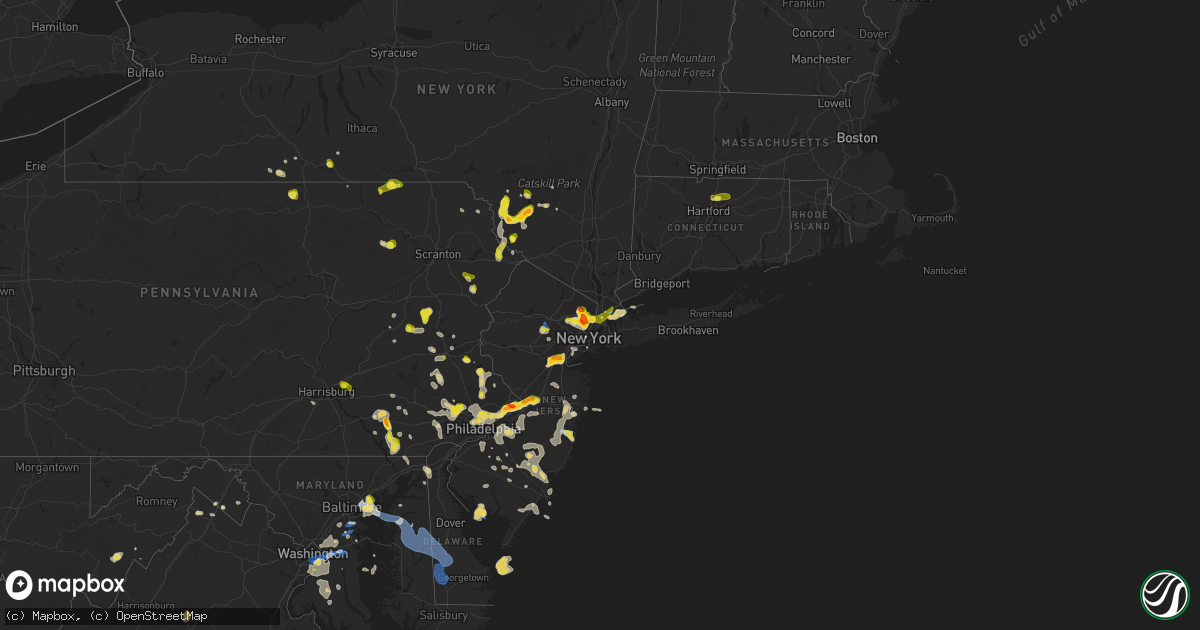
Hail Map on July 6, 2020
Get this storm
July 6 map
$229
one time, instant access
Download today. No call, no setup
Keep the $229
Bought the map and want the full workflow? Apply the entire $229 to a subscription within 7 days. None of it is wasted.
Every map, not just this one
This buys you this map. Subscription and you get every map we run, in the markets you choose from a few cities to whole states to nationwide. Plus real-time alerts the moment a storm fires.
Contact data
Name, contact info, occupancy, even credit band for addresses in the footprint. You go from where it hit to who to call.
Become the source they trust
Unlimited branding weather history reports on demand. You already have the documented answer ready for the property owner, and you are the one who showed up with it.
Property data and RoofTrace estimates
Pull up any address you have got, its value and the exact code rules for that jurisdiction, straight from One Click Code. Then RoofTrace estimates the squares, pitch, and roof value, priced the way you price.
States Impacted by Hail Map on July 6, 2020
Storm reports
Wisconsin
| Date | Description |
|---|---|
| 07/06/20206:51 PM CDT | 1 tree down. |
| 07/06/20205:00 PM CDT | Few trees down near intersection of county road w and evergreen street |
| 07/06/20203:22 PM CDT | A few trees down. |
| 07/06/20202:52 PM CDT | Tree down on county hwy a. Blocking both lanes of traffic. |
| 07/06/202010:42 AM CDT | Some small branches and one older tree knocked down. |
| 07/06/20203:27 AM CDT | At 826 PM CDT, a severe thunderstorm was located near Plainfield, or 16 miles west of Wautoma, moving east at 20 mph. HAZARD...60 mph wind gusts and penny size hail. SOURCE...Radar indicated. IMPACT...Expect damage to roofs, siding, and trees. Locations impacted include... Wautoma, Plainfield, Silver Lake, Dakota, Wild Rose, Richford, Coloma and Hancock. |
| 07/06/20202:07 AM CDT | At 707 PM CDT, a severe thunderstorm was located near Bangor, or near Sparta, moving east at 25 mph. HAZARD...60 mph wind gusts. SOURCE...Radar indicated. IMPACT...Expect damage to roofs, siding, and trees. This severe thunderstorm will be near... Sparta around 720 PM CDT.Other locations impacted by this severe thunderstorm include StMarys, Jackson Pass, Wilton, Rockland, Tunnel City, Middle Ridge andI 90 Exit 25. |
| 07/06/202012:56 AM CDT | At 556 PM CDT, a severe thunderstorm was located over Willow Reservoir, or 21 miles west of Rhinelander, moving northeast at 20 mph. HAZARD...60 mph wind gusts and quarter size hail. SOURCE...Radar indicated. IMPACT...Hail damage to vehicles is expected. Expect wind damage to roofs, siding, and trees. Locations impacted include... Rainbow Flowage, Willow Reservoir, Crystal Lake Scout Reservation, Minocqua, Sugar Camp, Hazelhurst, Lake Tomahawk, Mc Naughton, Goodnow and Gobler Lake Natural Area. |
| 07/06/202012:50 AM CDT | At 550 PM CDT, a severe thunderstorm was located near Crandon, moving east at 25 mph. HAZARD...60 mph wind gusts and quarter size hail. SOURCE...Radar indicated. IMPACT...Hail damage to vehicles is expected. Expect wind damage to roofs, siding, and trees. Locations impacted include... Crandon, North Otter Creek Natural Area, Woodlawn, Laona, Blackwell, Cavour, Otter Springs Recreation Area and Bear Lake Campground. |
| 07/06/202012:30 AM CDT | At 529 PM CDT, severe thunderstorms were located along a line extending from Antigo to 8 miles northwest of Wittenberg to near Mosinee, moving northeast at 30 mph. HAZARD...60 mph wind gusts and penny size hail. SOURCE...Radar indicated. IMPACT...Expect damage to roofs, siding, and trees. Locations impacted include... Antigo, Weston, Mosinee, Bevent, Wittenberg, Rothschild, Knowlton, Ringle, Polar and Norrie. |
| 07/06/202012:24 AM CDT | At 522 PM CDT, severe thunderstorms were near Harrison and 5 miles north of Enterprise, moving northeast at 25 mph. HAZARD...60 mph wind gusts and quarter size hail. SOURCE...Radar indicated. IMPACT...Hail damage to vehicles is expected. Expect wind damage to roofs, siding, and trees. Locations impacted include... Crandon, Harrison, Parrish, Nashville, Enterprise, Monico, Gagen, Kelly Lynn Bog Natural Area, Starks and Crescent Corner. |
| 07/05/202011:54 PM CDT | At 453 PM CDT, severe thunderstorms were located along a line extending from 6 miles south of Merrill to Wausau to near Mosinee to 12 miles east of Marshfield, moving east at 30 mph. HAZARD...60 mph wind gusts and penny size hail. SOURCE...Radar indicated. IMPACT...Expect damage to roofs, siding, and trees. Locations impacted include... Wausau, Weston, Rib Mountain, Mosinee, Rothschild, Schofield, Knowlton, Ringle, Birnamwood and Hatley. |
| 07/05/202010:08 PM CDT | At 308 PM CDT, a severe thunderstorm was located near Valders, or 10 miles west of Manitowoc, moving north at 20 mph. HAZARD...60 mph wind gusts and quarter size hail. SOURCE...Radar indicated. IMPACT...Hail damage to vehicles is expected. Expect wind damage to roofs, siding, and trees. Locations impacted include... Denmark, Valders, Cato, Mishicot, Larrabee, Cooperstown, Reedsville, Maple Grove, Whitelaw and Francis Creek. |
| 07/05/20207:36 PM CDT | 1 tree down on county rd e near town of burns. Time estimated from radar. |
North Dakota
| Date | Description |
|---|---|
| 07/06/20204:15 PM CDT | Drifts of hail and 2.00 inches of rain. |
Nebraska
| Date | Description |
|---|---|
| 07/06/20206:52 PM CDT | The wind was strong enough to move a trailer. There were also several limbs broken off of a tree. |
| 07/06/20206:49 PM CDT | A local report indicates 1.50 inch wind near 11 SE ELI |
| 07/06/20206:40 PM CDT | A local report indicates 60 MPH wind near 4 ENE BRUNSWICK |
| 07/06/20206:34 PM CDT | Penny-sized hail and heavy rain in addition to the strong winds. |
| 07/06/20206:28 PM CDT | A local report indicates 67 MPH wind near 1 W PONCA |
| 07/06/20206:10 PM CDT | A local report indicates 1.50 inch wind near 1 W CREIGHTON |
| 07/06/20205:51 PM CDT | Some pea sized hail also. |
| 07/06/20205:36 PM CDT | Trained spotter estimated wind at about 60 mph. |
| 07/06/20205:25 PM CDT | A local report indicates 1.00 inch wind near 1 ESE CREIGHTON |
| 07/06/20205:24 PM CDT | Public reported golf ball sized hail in creighton. |
| 07/06/20205:22 PM CDT | Report from mping: ping pong ball |
| 07/06/20206:42 AM CDT | At 1142 PM CDT, a severe thunderstorm was located 7 miles southeast of Ringgold, or 8 miles west of Stapleton, moving east at 20 mph. HAZARD...60 mph wind gusts and quarter size hail. SOURCE...Radar indicated. IMPACT...Hail damage to vehicles is expected. Expect wind damage to roofs, siding, and trees. Locations impacted include... Stapleton and Gandy. This includes the following highways... Highway 92 between mile markers 219 and 246. Highway 83 between mile markers 100 and 114. |
| 07/06/20205:14 AM CDT | At 1011 PM MDT/1111 PM CDT/, severe thunderstorms were located along a line extending from 3 miles southeast of Okaton to 4 miles southeast of Swett, moving southeast at 35 mph. HAZARD...70 mph wind gusts and quarter size hail. SOURCE...Radar indicated. IMPACT...Hail damage to vehicles is expected. Expect considerable tree damage. Wind damage is also likely to mobile homes, roofs, and outbuildings. Severe thunderstorms will be near... Lacreek Wildlife Refuge and White River around 1130 PM CDT. Saint Francis, Mission, and Wood around 1205 AM CDT. |
| 07/06/20204:53 AM CDT | At 952 PM CDT, severe thunderstorms were located along a line extending from 10 miles northeast of Rose to 16 miles north of Brewster, moving southeast at 25 mph. HAZARD...60 mph wind gusts and quarter size hail. SOURCE...Radar indicated. IMPACT...Hail damage to vehicles is expected. Expect wind damage to roofs, siding, and trees. Locations impacted include... Rose, Fox Bayou, Duff, Almeria Meadow State Wildlife Management Area, Horseshoe Bend Lake, Johnsons Corner and Carson Lake.This includes Highway 183 between mile markers 135 and 162. |
| 07/06/20203:17 AM CDT | At 817 PM CDT, severe thunderstorms were located along a line extending from near Johnstown to near Valentine National Wildlife Refuge, moving southeast at 20 mph. HAZARD...60 mph wind gusts and quarter size hail. SOURCE...Radar indicated. IMPACT...Hail damage to vehicles is expected. Expect wind damage to roofs, siding, and trees. Locations impacted include... Ainsworth, Johnstown, Elsmere, Valentine National Wildlife Refuge, Wood Lake, Hofeld Lake, Moon Lake, Willow Lake State Wildlife Management Area and Long Lake State Wildlife Management Area.This includes the following highways... Highway 20 between mile markers 218 and 244. Highway 83 between mile markers 183 and 193. |
| 07/06/20203:12 AM CDT | At 812 PM CDT, severe thunderstorms were located along a line extending from 7 miles south of Meadow Grove to 6 miles west of Elgin, moving south at 20 mph. HAZARD...60 mph wind gusts and quarter size hail. SOURCE...Radar indicated. IMPACT...Hail damage to vehicles is expected. Expect wind damage to roofs, siding, and trees. Locations impacted include... Madison, Battle Creek, Newman Grove, Elgin, Petersburg, Oakdale, Meadow Grove, Lindsay, Tilden and Loretto. |
| 07/06/20202:55 AM CDT | At 754 PM CDT/654 PM MDT/, a severe thunderstorm was located 11 miles south of Merritt Reservoir, or 29 miles southwest of Valentine, moving southeast at 35 mph. HAZARD...Golf ball size hail and 60 mph wind gusts. SOURCE...Radar indicated. IMPACT...People and animals outdoors will be injured. Expect hail damage to roofs, siding, windows, and vehicles. Expect wind damage to roofs, siding, and trees. Locations impacted include... Brownlee, Highway 83 crossing Goose Creek and Highway 83 crossing the North Loup River.This includes the following highways... Highway 97 between mile markers 100 and 106. Highway 83 between mile markers 158 and 182. |
| 07/06/20202:38 AM CDT | At 737 PM MDT, severe thunderstorms were located along a line extending from 8 miles east of Antioch to near Crescent Lake National Wildlife Refuge to 18 miles northeast of Lisco to 7 miles southwest of Oshkosh, moving east at 30 mph. HAZARD...60 mph wind gusts and nickel size hail. SOURCE...Radar indicated. IMPACT...Expect damage to roofs, siding, and trees. Locations impacted include... Oshkosh, Ellsworth, Lewellen, Ashby, Antioch, Crescent Lake National Wildlife Refuge, Dogtown Flats, Swede Lake, Deer Lake, Britton Lake, Mumper, Bourquim Hill, Herman Lake, Adams Flats, Sugar Loaf Hill, Eagle Gulch Campground, Ruthon, Clear Creek State Wildlife Management Area, Rackett and Patterson Lake.This includes the following highways... Highway 250 between mile markers 1 and 7. Highway 2 between mile markers 100 and 139. Highway 92 between mile markers 115 and 130. |
| 07/06/20202:20 AM CDT | At 719 PM CDT, a severe thunderstorm was located 10 miles north of Meadow Grove, or 21 miles northwest of Norfolk, moving southeast at 20 mph. HAZARD...60 mph wind gusts and quarter size hail. SOURCE...Radar indicated. IMPACT...Hail damage to vehicles is expected. Expect wind damage to roofs, siding, and trees. Locations impacted include... Norfolk, Pierce, Neligh, Battle Creek, Elgin, Clearwater, Oakdale, Meadow Grove, Hadar, Tilden and Willow Creek State Recreation Area. |
| 07/06/20201:43 AM CDT | Tree limbs downed. |
| 07/06/20201:42 AM CDT | At 642 PM CDT, severe thunderstorms were located along a line extending from Plainview to 10 miles north of Neligh to Orchard, moving southeast at 10 mph. HAZARD...Ping pong ball size hail and 60 mph wind gusts. SOURCE...Radar indicated. IMPACT...People and animals outdoors will be injured. Expect hail damage to roofs, siding, windows, and vehicles. Expect wind damage to roofs, siding, and trees. Locations impacted include... Osmond, Clearwater, Orchard, Brunswick, Royal, Foster, McLean and The Highway 81 And 20 Junction. |
| 07/06/20201:14 AM CDT | At 613 PM CDT, a severe thunderstorm was located over Creighton, or 34 miles southwest of Lewis And Clark State Recreation Area, moving southeast at 10 mph. HAZARD...60 mph wind gusts and half dollar size hail. SOURCE...Radar indicated. IMPACT...Hail damage to vehicles is expected. Expect wind damage to roofs, siding, and trees. Locations impacted include... Plainview, Creighton, Winnetoon and Bazile Mills. |
| 07/06/202012:59 AM CDT | At 559 PM CDT, a severe thunderstorm was located near Orchard, or 22 miles east of O'neill, moving northeast at 10 mph. HAZARD...Golf ball size hail and 60 mph wind gusts. SOURCE...Radar indicated. IMPACT...People and animals outdoors will be injured. Expect hail damage to roofs, siding, windows, and vehicles. Expect wind damage to roofs, siding, and trees. Locations impacted include... Orchard and Ashfall Fossil Beds State Historical Park. |
| 07/06/202012:52 AM CDT | At 551 PM CDT, a severe thunderstorm was located west of Creighton, or 33 miles east of O'neill, moving east at 10 mph. HAZARD...60 mph wind gusts and quarter size hail. SOURCE...Radar indicated. IMPACT...Hail damage to vehicles is expected. Expect wind damage to roofs, siding, and trees. Locations impacted include... Creighton, Winnetoon, Bazile Mills and The Highway 14 And 59 Junction. |
| 07/06/202012:42 AM CDT | At 542 PM CDT, a severe thunderstorm was located near Verdigre, or 26 miles southwest of Tyndall, moving east at 10 mph. HAZARD...Ping pong ball size hail and 60 mph wind gusts. SOURCE...Radar indicated. IMPACT...People and animals outdoors will be injured. Expect hail damage to roofs, siding, windows, and vehicles. Expect wind damage to roofs, siding, and trees. Locations impacted include... Verdigre and Center. |
| 07/06/202012:12 AM CDT | At 512 PM CDT, a severe thunderstorm was located near Creighton, or 36 miles east of O'neill, moving east at 10 mph. HAZARD...60 mph wind gusts and quarter size hail. SOURCE...Radar indicated. IMPACT...Hail damage to vehicles is expected. Expect wind damage to roofs, siding, and trees. Locations impacted include... Plainview, Creighton, Winnetoon and Bazile Mills. |
| 07/05/202011:38 PM CDT | At 436 PM CDT, a severe thunderstorm was located near Mayfield, or 9 miles north of Yankton, moving east at 10 mph. HAZARD...60 mph wind gusts and quarter size hail. SOURCE...Radar indicated. IMPACT...Hail damage to vehicles is expected. Expect wind damage to roofs, siding, and trees. This severe thunderstorm will be near... Mayfield around 445 PM CDT. Lesterville around 450 pm CDT Mission Hill around 505 PM CDT. Volin around 515 PM CDT.Other locations impacted by this severe thunderstorm includeGayville, Lesterville and St. Helena Boat Dock. |
| 07/05/20209:17 PM CDT | A local report indicates 60 MPH wind near 5 SW BINGHAM |
| 07/05/20208:55 PM CDT | Measured on a personal weather sensor. |
| 07/05/20208:42 PM CDT | Numerous large limbs down around lindsay. |
| 07/05/20208:32 PM CDT | Trees broken off. Numerous limbs down across town. |
| 07/05/20208:17 PM CDT | Estimated 60 to 70 mph gusts. |
| 07/05/20207:57 PM CDT | Lawn furniture blown around. Small branches broken. |
| 07/05/20207:46 PM CDT | Significant damage to a hog barn with partial roof removal. Corn plants flattened by wind. 2 miles east of this location had crop fields completely stripped of leaves d |
| 07/05/20207:39 PM CDT | Trees and limbs down in tilden. Accompanied by dime size hail. Neighbor measured 64 mph on personal weather station. |
| 07/05/20207:00 PM CDT | A local report indicates 1.75 inch wind near 9 SSW NENZEL |
Delaware
| Date | Description |
|---|---|
| 07/06/20206:00 PM CDT | Downed tree limbs and wires near brick mill road and dove run boulevard in odessa. Time estimated from radar. |
| 07/06/20204:50 PM CDT | Downed tree limbs and wires near pleasant hill road in newark. Time estimated from radar. |
| 07/06/20203:58 AM CDT | At 858 PM EDT, severe thunderstorms were located along a line extending from Sycamore to near Sharptown to 7 miles southeast of Cambridge, moving southeast at 30 mph. HAZARD...60 mph wind gusts. SOURCE...Radar indicated. IMPACT...Expect damage to trees and powerlines. Severe thunderstorms will be near, Hebron around 910 PM EDT. Delmar around 915 PM EDT. Salisbury, Fruitland and Salisbury University around 925 PM EDT. Parsonsburg around 930 PM EDT. Princess Anne, Berlin, Ocean Pines and Newark around 945 PM EDT.Other locations impacted by these severe thunderstorms includeBishop, Wetipquin, Brookview, Trinity, Eldorado, Eden, Longridge,Chesapeake Heights, Pittsville and Powellville. |
| 07/06/20203:53 AM CDT | At 851 PM EDT, severe thunderstorms were located along a line extending from near Viola to near Ellendale to near Sharptown, moving southeast at 30 mph. HAZARD...60 mph wind gusts. SOURCE...Radar indicated. IMPACT...Damage to roofs, siding, trees, and power lines is possible. Locations impacted include... Georgetown, Milford, Seaford, Millsboro, Laurel, Harrington, Lewes, Milton, Bridgeville, Delmar, Dagsboro, Millville, Ellendale, Viola, Gumboro, Andrewsville, Sycamore, Big Stone Beach, Long Neck and Felton. |
| 07/06/20203:21 AM CDT | At 819 PM EDT, severe thunderstorms were located along a line extending from near Hazlettville to near Andrewsville to near Oxford, moving southeast at 30 mph. HAZARD...60 mph wind gusts. SOURCE...Radar indicated. IMPACT...Damage to roofs, siding, trees, and power lines is possible. Locations impacted include... Georgetown, Milford, Seaford, Laurel, Harrington, Federalsburg, Milton, Bridgeville, Trappe, Preston, Ellendale, Bowers, Smithville, Rising Sun-Lebanon, Agner, Choptank, Dover Base Housing, Windyhill, Rising Sun and Sycamore. |
| 07/06/20203:20 AM CDT | At 819 PM EDT, severe thunderstorms were located along a line extending from near Andrewsville to Windyhill to 7 miles south of Tilghman Island, moving east at 35 mph. HAZARD...60 mph wind gusts and penny size hail. SOURCE...Radar indicated. IMPACT...Expect damage to trees and powerlines. Locations impacted include... Cambridge, Hurlock, Sharptown, Secretary, Vienna, University Of Maryland Center For Environmental Studies, East New Market, Mardela Springs, Galestown, Church Creek, Brookview, Eldorado, Madison, Hudson, Lloyds, Taylors Island, Woolford, Linkwood and Bucktown. |
| 07/06/20202:41 AM CDT | At 739 PM EDT, severe thunderstorms were located along a line extending from Smyrna to Hope to near Chesapeake Beach, moving southeast at 30 mph. HAZARD...60 mph wind gusts and penny size hail. SOURCE...Radar indicated. IMPACT...Damage to roofs, siding, trees, and power lines is possible. Locations impacted include... Dover, Easton, Centerville, Talbot, Smyrna, Milford, Chestertown, Denton, Centreville, Harrington, Camden, Clayton, Federalsburg, Greensboro, Oakland, Ridgely, Cheswold, Trappe, St. Michaels and Church Hill. |
| 07/06/20202:03 AM CDT | At 703 PM EDT, a severe thunderstorm was located near Langford, or 11 miles east of Millers Island, moving southeast at 35 mph. HAZARD...60 mph wind gusts and quarter size hail. SOURCE...Radar indicated. IMPACT...Minor damage to vehicles is possible. Wind damage to roofs, siding, trees, and power lines is possible. Locations impacted include... Centerville, Chestertown, Denton, Centreville, Greensboro, Oakland, Ridgely, Rock Hall, Church Hill, Sudlersville, Goldsboro, Old Town, Starr, Jumptown, Newtown, Morgnec, Crumpton, Langford, Starkey Corner and Carville. |
| 07/05/20208:03 PM CDT | Downed wires on concord pond road. Time estimated from radar. |
| 07/05/20208:03 PM CDT | Downed tree limb and power lines near ritchie lane in bridgeville. Time estimated from radar. |
| 07/05/20208:00 PM CDT | Downed tree and power lines near holley valley road in seaford. Time estimated from radar. |
| 07/05/20207:46 PM CDT | A local report indicates 59 MPH wind near 2 SSE GREENWOOD |
| 07/05/20207:20 PM CDT | Trees and wires down to the north and west of harrington. Time estimated from radar. |
| 07/05/20207:18 PM CDT | Downed power lines near park brown road near sandtown. Time estimated from radar. |
Ohio
| Date | Description |
|---|---|
| 07/06/20205:45 PM CDT | 50 ft tall pine tree down into house. Time estimated. |
| 07/06/20205:35 PM CDT | Several trees downed in miami township... Including one into a residence. Time of event estimated. |
| 07/06/20203:15 PM CDT | Barn knocked down. |
New Jersey
| Date | Description |
|---|---|
| 07/06/20204:17 PM CDT | Trees and wires down in southeast of mertztown. Time estimated from radar. |
| 07/06/20203:45 PM CDT | Large tree limbs down blocking roadway |
| 07/06/20203:27 PM CDT | A local report indicates 1.00 inch wind near RIDGEWOOD |
| 07/06/20203:25 PM CDT | A local report indicates 1.00 inch wind near GLEN ROCK |
| 07/06/20203:24 PM CDT | A local report indicates 1.00 inch wind near FAIR LAWN |
| 07/06/20203:00 PM CDT | Tree down on madison ave. Time estimated from radar. |
| 07/06/20202:58 PM CDT | In addition to many quarter to ping pong ball sized hailstones. |
| 07/06/20202:56 PM CDT | A local report indicates 60 MPH wind near HASBROUCK HEIGHTS |
| 07/06/20202:55 PM CDT | Tree down on maple ave. Time estimated from radar. |
| 07/06/20202:55 PM CDT | A large tree was downed on south st. Time estimated from radar. |
| 07/06/20202:55 PM CDT | A local report indicates 1.25 inch wind near HASBROUCK HEIGHTS |
| 07/06/20202:52 PM CDT | A local report indicates 1.00 inch wind near LODI |
| 07/06/20202:48 PM CDT | Downed trees and wires near mount kemble avenue in new vernon. Time estimated from radar. |
| 07/06/20202:43 PM CDT | Downed trees and wires near jenks hill road in new vernon. Time estimated from radar. |
| 07/06/20202:43 PM CDT | Reports of downed power lines in mendham. Time estimated from radar. |
| 07/06/20202:40 PM CDT | Downed trees and wires near morris avenue in morristown. Time estimated from radar. |
| 07/06/20202:38 PM CDT | Trees and wires down in morris twp. Time estimated from radar. |
| 07/06/20202:38 PM CDT | Downed trees and wires near speedwell avenue in morris plains. Time estimated from radar. |
| 07/06/20202:37 PM CDT | Corrects previous tstm wnd dmg report from morristown. Trees and wires down in morristown. Several cars were damaged or destroyed by the falling trees. Time estimated f |
| 07/06/20202:37 PM CDT | Trees and wires down in morris plains. Time estimated from radar. |
| 07/06/20202:36 PM CDT | Corrects previous hail report from morristown. Quarter-sized hail at ginty field in morristown. Time modified based on radar... Social media information... And nearby h |
| 07/06/20202:35 PM CDT | A local report indicates 1.00 inch wind near PARAMUS |
| 07/06/20202:32 PM CDT | A local report indicates 1.00 inch wind near ROCHELLE PARK |
| 07/06/20202:30 PM CDT | Trees and wires down near the intersection of whippany road and ford hill road near whippany. Time estimated from radar. |
| 07/06/20202:30 PM CDT | Nickel to quarter size hail. |
| 07/06/20202:30 PM CDT | Quarter-sized hail at ginty field in morristown. Time estimated from radar. |
| 07/06/20202:28 PM CDT | Tree down on wires near ellis parkway in colonia. Time estimated from radar. |
| 07/06/20202:25 PM CDT | Quarter to ping pong ball size hail. |
| 07/06/20202:24 PM CDT | Report via social media with video of hail up to about quarter size. Some small dents on vehicles reported. Time estimated from radar. |
| 07/06/20202:20 PM CDT | A local report indicates 1.00 inch wind near 1 W PERTH AMBOY |
| 07/06/20202:20 PM CDT | A local report indicates 1.00 inch wind near 1 SSW SOUTH PLAINFIELD |
| 07/06/20202:10 PM CDT | Downed trees and wires near pleasant valley road in old bridge. Time estimated from radar. |
| 07/06/20202:08 PM CDT | Downed wires near sea girt avenue. Time estimated from radar. |
| 07/06/20202:00 PM CDT | Report via social media with photos. Time estimated from radar. |
| 07/06/20202:00 PM CDT | Downed trees and wires near ridgewood road in allenwood. Time estimated from radar. |
| 07/06/20201:45 PM CDT | A local report indicates 61 MPH wind near OCEAN COUNTY AIRPORT (K |
| 07/06/20201:45 PM CDT | Njweathernet site nj66. |
| 07/06/20201:40 PM CDT | Downed tree limbs and wires near wilson raod in englishtown. Time estimated from radar. |
| 07/06/20201:32 PM CDT | Reports of trees and wires down in lindenwold. Time estimated from radar. |
| 07/06/20201:26 PM CDT | Mping report. |
| 07/06/20201:23 PM CDT | Tree on wires on creek road at route 38 in hainesport. Time estimated from radar. |
| 07/06/20201:20 PM CDT | Multiple trees and wires down on route 73 in marlton. Report via social media. Time estimated from radar. |
| 07/06/20201:15 PM CDT | Downed wires on nj-73 both directions between brick rd and maple ave. All lanes closed and detoured. Time estimated from radar. |
| 07/06/20201:14 PM CDT | Downed tree limbs and wires near branch street in medford. Time estimated from radar. |
| 07/06/20201:11 PM CDT | Reports of tree limbs and wires down near georgia trail in medford. Time estimated from radar. |
| 07/06/20201:10 PM CDT | Report via social media with photos of ping pong ball size hail. |
| 07/06/20201:10 PM CDT | Report via social media with photo of hail a little larger than quarter size. Time estimated from radar. |
| 07/06/20201:10 PM CDT | Report via social media with photos of hail around quarter size. |
| 07/06/20201:08 PM CDT | Several reports of tree limbs and wires down in the evesboro and marlton areas. Time estimated from radar. |
| 07/06/20201:06 PM CDT | Downed tree and wires near locust avenue in haddon twp. Time estimated from radar. |
| 07/06/20201:06 PM CDT | Several reports of trees and wires down in the springdale... Society hill... And ellisburg areas. Time estimated from radar. |
| 07/06/20201:05 PM CDT | Report via social media with photo of hail to around quarter size. Time estimated from radar. |
| 07/06/20201:00 PM CDT | Mainly penny size but a few stones to quarter size. Hail fell for around 15 minutes. |
| 07/06/20201:00 PM CDT | Downed wires near monmouth road in springfiled twp. Time estimated from radar. |
| 07/06/20201:00 PM CDT | Report with photo of hail to about quarter size. |
| 07/06/202012:55 PM CDT | Tree limbs and wires down near columbia boulevard in cherry hill. Time estimated from radar. |
| 07/06/202012:53 PM CDT | Downed tree and wires near ashley lane in lumberton. Time estimated from radar. |
| 07/06/202012:47 PM CDT | Downed wires near green street in mount holly. Time estimated from radar. |
| 07/06/202011:51 AM CDT | Downed wires near riverside township high school. Time estimated from radar. |
| 07/06/202012:43 AM CDT | At 543 PM EDT, severe thunderstorms were located along a line extending from near Strathmere to near Cape May Court House to near Fortesque, moving east at 40 mph. HAZARD...60 mph wind gusts and quarter size hail. SOURCE...Radar indicated. IMPACT...Minor damage to vehicles is possible. Wind damage to roofs, siding, trees, and power lines is possible. Locations impacted include... Millville, Ocean City, Cape May, North Wildwood, Laurel Lake, Wildwood Crest, Woodbine, Sea Isle City, Estell Manor, Avalon, West Cape May, Stone Harbor, Corbin City, Newport, Cape May Court House, Leesburg, Scotch Bonnet, Beesleys Point, Seaville and Bricksboro.This includes Garden State Parkway between mile markers 0 and 27. |
| 07/05/202011:45 PM CDT | At 444 PM EDT, severe thunderstorms were located along a line extending from near Surf City to Atlantic City to near Marmora to near Bricksboro to Shiloh, moving south at 35 mph. HAZARD...60 mph wind gusts and quarter size hail. SOURCE...Radar indicated. IMPACT...Minor damage to vehicles is possible. Wind damage to roofs, siding, trees, and power lines is possible. Locations impacted include... Vineland, Atlantic City, Millville, Bridgeton, Ocean City, Cape May, Cumberland, Pleasantville, Somers Point, Ventnor City, Brigantine, Northfield, Absecon, Margate City, North Wildwood, Laurel Lake, Wildwood Crest, Woodbine, Sea Isle City and Estell Manor.This includes the following highways... Garden State Parkway between mile markers 0 and 36. Atlantic City Expressway between mile markers 0 and 6. |
| 07/05/202011:39 PM CDT | At 439 PM EDT, a severe thunderstorm was located over Riverdale, or near Bergenfield, moving east at 5 mph. HAZARD...Ping pong ball size hail and 60 mph wind gusts. SOURCE...Radar indicated. IMPACT...People and animals outdoors will be injured. Expect hail damage to roofs, siding, windows, and vehicles. Expect wind damage to trees and power lines. Locations impacted include... Yonkers, New Rochelle, White Plains, Bergenfield, Paramus, Rye, Tarrytown, Dobbs Ferry, Nyack, Rfk Bridge, Flushing, Throgs Neck Bridge, Sleepy Hollow, Mott Haven and Tappan. |
| 07/05/202010:59 PM CDT | At 358 PM EDT, severe thunderstorms were located along a line extending from near Paterson to Upper West Side, moving south at 5 mph. HAZARD...Ping pong ball size hail and 60 mph wind gusts. SOURCE...Radar indicated. IMPACT...People and animals outdoors will be injured. Expect hail damage to roofs, siding, windows, and vehicles. Expect wind damage to trees and power lines. Severe thunderstorms will be near... New York and Midtown Manhattan around 405 PM EDT. Secaucus around 415 PM EDT. Union City around 420 PM EDT. Hoboken around 435 PM EDT. East Village around 440 PM EDT. Soho around 445 PM EDT. Kearny and Lower East Side around 450 PM EDT. Passaic around 455 PM EDT. Newark and Jersey City around 500 PM EDT. |
| 07/05/202010:47 PM CDT | At 346 PM EDT, severe thunderstorms were located along a line extending from Elwood-Magnolia to near Mullica Hill, moving southeast at 20 mph. HAZARD...60 mph wind gusts and quarter size hail. SOURCE...Radar indicated. IMPACT...Minor damage to vehicles is possible. Wind damage to roofs, siding, trees, and power lines is possible. Locations impacted include... Vineland, Atlantic City, Millville, Bridgeton, Pleasantville, Glassboro, Hammonton, Ventnor City, Pitman, Northfield, Absecon, Clayton, Margate City, Buena, Egg Harbor City, Woodstown, Alloway, Weymouth, Swedesboro and Estell Manor.This includes the following highways... New Jersey Turnpike near exit 2. Interstate 295 in New Jersey between mile markers 12 and 13. Garden State Parkway between mile markers 32 and 40. Atlantic City Expressway between mile markers 3 and 41. |
| 07/05/202010:36 PM CDT | At 336 PM EDT, a severe thunderstorm was located over Morristown, moving south at 10 mph. HAZARD...70 mph wind gusts and half dollar size hail. SOURCE...Radar indicated. IMPACT...Minor damage to vehicles is possible. Expect considerable tree damage. Wind damage is also likely to mobile homes, roofs, and outbuildings. Locations impacted include... Morristown, Somerville, Bridgewater, Madison, Florham Park, East Hanover, Chatham, Morris Plains, Mendham, Peapack And Gladstone, Chester, Far Hills, Parsippany, Long Valley, Martinsville, Millington, Basking Ridge, Succasunna-Kenvil, North Plainfield and Bernardsville.This includes the following highways... Interstate 78 in New Jersey between mile markers 25 and 42. Interstate 80 in New Jersey between mile markers 42 and 46. Interstate 287 in New Jersey between mile markers 15 and 42. |
| 07/05/202010:26 PM CDT | At 325 PM EDT, a severe thunderstorm was located over Edison, or near Perth Amboy, moving east at 5 mph. HAZARD...60 mph wind gusts and quarter size hail. SOURCE...Radar indicated. IMPACT...Minor hail damage to vehicles is possible. Expect wind damage to trees and power lines. This severe thunderstorm will be near... Clark around 340 PM EDT. Linden and Tottenville around 420 PM EDT. Huguenot and Todt Hill around 430 PM EDT. |
| 07/05/202010:18 PM CDT | At 318 PM EDT, a severe thunderstorm was located over Edison, or near Perth Amboy, moving northeast at 20 mph. HAZARD...60 mph wind gusts and quarter size hail. SOURCE...Radar indicated. IMPACT...Minor damage to vehicles is possible. Wind damage to roofs, siding, trees, and power lines is possible. Locations impacted include... New Brunswick, Perth Amboy, Somerset, Edison, Old Bridge, East Brunswick, Sayreville, North Brunswick, Carteret, Middlesex, Bound Brook, Colonia, North Brunswick Township, Society Hill, Woodbridge, South Plainfield, North Plainfield, South River, Highland Park and Metuchen.This includes the following highways... New Jersey Turnpike between exits 10 and 13. Interstate 78 in New Jersey between mile markers 39 and 42. Interstate 287 in New Jersey between mile markers 0 and 12. Garden State Parkway between mile markers 123 and 134. |
| 07/05/202010:14 PM CDT | At 314 PM EDT, severe thunderstorms were located along a line extending from near Tinton Falls to near Manasquan to Dover Beaches North to near Beachwood, moving east at 15 mph. HAZARD...60 mph wind gusts and quarter size hail. SOURCE...Radar indicated. IMPACT...Minor damage to vehicles is possible. Wind damage to roofs, siding, trees, and power lines is possible. Locations impacted include... Toms River, Long Branch, Asbury Park, Tinton Falls, Red Bank, Beachwood, Manasquan, Point Pleasant Beach, Seaside Heights, Mantoloking, Allenwood, Dover Beaches North, Dover Beaches South, Elberon, Brick Township, Collingwood Park, Lincroft, Point Pleasant, Eatontown and West Long Branch.This includes the following highways... Interstate 195 in New Jersey near mile marker 34. Garden State Parkway between mile markers 72 and 80, and betweenmile markers 96 and 112. |
| 07/05/20209:41 PM CDT | At 240 PM EDT, severe thunderstorms were located along a line extending from near Dublin to near Doylestown to Richboro, moving northeast at 15 mph. HAZARD...60 mph wind gusts and quarter size hail. SOURCE...Radar indicated. IMPACT...Minor damage to vehicles is possible. Wind damage to roofs, siding, trees, and power lines is possible. Locations impacted include... Lansdale, Perkasie, Doylestown, Byram, Hatboro, Bedminster, Ambler, Chalfont, Tinicum, New Hope, Newtown, Dublin, Bryn Athyn, Ivyland, Stockton, Washington Crossing, Fricks, Willow Grove, Lumberville and Richboro.This includes the following highways... Pennsylvania Turnpike between mile markers 334 and 347. Northeast Extension between mile markers 21 and 22. |
| 07/05/20209:00 PM CDT | At 200 PM EDT, severe thunderstorms were located along a line extending from Windsor to Cream Ridge to Browns Mills to near Tabernacle, moving east at 15 mph. HAZARD...60 mph wind gusts and quarter size hail. SOURCE...Radar indicated. IMPACT...Minor damage to vehicles is possible. Wind damage to roofs, siding, trees, and power lines is possible. Locations impacted include... Toms River, Long Branch, Asbury Park, Lakewood, Jackson, Howell, Marlboro, Manalapan, Tinton Falls, Red Bank, Beachwood, Manasquan, Hightstown, Point Pleasant Beach, Presidential Lakes Estates, Seaside Heights, Lakehurst, Allentown, Pemberton and Farmingdale.This includes the following highways... New Jersey Turnpike between exits 8 and 8A. Interstate 195 in New Jersey between mile markers 2 and 34. Interstate 295 in New Jersey near mile marker 65. Garden State Parkway between mile markers 73 and 111. |
Wyoming
| Date | Description |
|---|---|
| 07/06/20206:50 PM CDT | 6 inch tree limbs broke... Winds of 60 to 70 mph estimated. |
| 07/06/20206:50 PM CDT | 6 inch tree limbs broke... Winds of 60 to 70 mph estimated. |
| 07/06/20206:49 PM CDT | A local report indicates 1.00 inch wind near 4 SSE DEVILS TOWER |
| 07/06/20206:30 PM CDT | Tennis ball to baseball hail. Funnel cloud... But didn't touch down. |
| 07/06/20206:05 PM CDT | Several inches of large hail. Broken windows. |
| 07/06/20206:00 PM CDT | Tennis ball to baseball size hail. Lasted 15-20 minutes. |
| 07/06/20205:59 PM CDT | A local report indicates 58 MPH wind near 7 NW ROCKYPOINT |
| 07/06/202012:29 AM CDT | At 528 PM MDT, a severe thunderstorm was located 3 miles west of Devils Tower National Monument, or 22 miles northwest of Sundance, moving east at 40 mph. HAZARD...Tennis ball size hail. SOURCE...Radar indicated. IMPACT...People and animals outdoors will be injured. Expect damage to roofs, siding, windows, and vehicles. This severe thunderstorm will be near... Devils Tower Junction around 535 PM MDT. Cook Lake and Warren Peak around 555 PM MDT. Aladdin around 610 PM MDT. Beulah around 620 PM MDT.This includes Interstate 90 in Wyoming between Mile Markers 183 and206. |
| 07/06/202012:14 AM CDT | At 513 PM MDT, a severe thunderstorm was located over Biddle, or 26 miles south of Broadus, moving east southeast at 40 mph. HAZARD...60 mph wind gusts and half dollar size hail. SOURCE...Radar indicated. IMPACT...Hail damage to vehicles is expected. Expect wind damage to roofs, siding, and trees. Locations impacted include... Biddle, Belle Creek and Ridge. This replaces the warning previously in effect for this area. |
| 07/05/202011:58 PM CDT | At 458 PM MDT, a severe thunderstorm was located 5 miles west of Oshoto, or 32 miles northeast of Gillette, moving east at 30 mph. HAZARD...60 mph wind gusts and half dollar size hail. SOURCE...Radar indicated. IMPACT...Hail damage to vehicles is expected. Expect wind damage to roofs, siding, and trees. This severe thunderstorm will be near... Oshoto around 510 PM MDT. |
| 07/05/202011:34 PM CDT | At 434 PM MDT, a severe thunderstorm was located 6 miles south of Biddle, or 30 miles south of Broadus, moving southeast at 25 mph. HAZARD...Two inch hail and 60 mph wind gusts. SOURCE...Radar indicated. IMPACT...People and animals outdoors will be injured. Expect hail damage to roofs, siding, windows, and vehicles. Expect wind damage to roofs, siding, and trees. This severe thunderstorm will be near... Rockypoint around 500 PM MDT. Lightning Flat around 505 PM MDT. |
| 07/05/202011:10 PM CDT | At 409 PM MDT, a severe thunderstorm was located 18 miles west of Biddle, or 24 miles southwest of Broadus, moving east at 15 mph. HAZARD...60 mph wind gusts and half dollar size hail. SOURCE...Radar indicated. IMPACT...Hail damage to vehicles is expected. Expect wind damage to roofs, siding, and trees. Locations impacted include... Biddle. |
| 07/05/20207:47 PM CDT | A local report indicates 1.75 inch wind near 11 SE SUNDANCE |
| 07/05/20207:47 PM CDT | Multiple trees snapped |
Maryland
| Date | Description |
|---|---|
| 07/06/20206:54 PM CDT | Video on social media of winds which appeared to be at least 60 mph. Time estimated from radar. |
| 07/06/20206:50 PM CDT | Several trees down due to straight line winds on sparkie lane in queen anne. Time estimated from radar. |
| 07/06/20206:44 PM CDT | Md 313 closed in both directions from hollingsworth circle to jones rd due to storm debris. Time estimated from radar. |
| 07/06/20206:44 PM CDT | State highway 8 closed at dorchester road from wind-blown debris. Time estimated from radar. |
| 07/06/20206:35 PM CDT | Trees down near and around centreville. |
| 07/06/20206:30 PM CDT | Md-304 closed near us-301 due to storm debris. Time estimated from radar. |
| 07/06/20206:28 PM CDT | Tree down near md 7 and rossville rd |
| 07/06/20206:28 PM CDT | Md-290 closed in both directions near front st due to storm debris. Time estimated from radar. |
| 07/06/20206:23 PM CDT | Some sporadic trees snapped from straight line winds along lands end road... Especially between jack elliott way and bookers whart road... Then east southeastward towar |
| 07/06/20206:20 PM CDT | State highway 20 westbound at state highway 446 closed from wind-blown debris. Time estimated from radar. |
| 07/06/20206:20 PM CDT | Downed trees and wires near the intersection of massey road and golts road. Time estimated from radar. |
| 07/06/20206:19 PM CDT | State highway 20 westbound at bell rose lane closed from wind-blown debris. Time estimated from radar. |
| 07/06/20206:17 PM CDT | Tree down at suitland road... West of arnold road. |
| 07/06/20206:17 PM CDT | Tree that fell on a house in the upper marlboro area. |
| 07/06/20206:12 PM CDT | Tcbm2. |
| 07/06/20206:03 PM CDT | Multiple trees down in the area of 2800 lodge farm rd |
| 07/06/20206:00 PM CDT | A local report indicates 1.00 inch wind near 2 W ELKRIDGE |
| 07/06/20205:57 PM CDT | Wires down across us50 at kenilworth ave |
| 07/06/20205:54 PM CDT | A local report indicates 58 MPH wind near 1 WNW GREEN HAVEN |
| 07/06/20205:53 PM CDT | Multiple trees and powerlines down in the 8500 to 8700 block of pulaski hwy |
| 07/06/20205:43 PM CDT | Tree down on rt 197 south of us-50 |
| 07/06/20205:43 PM CDT | Tree down at md-2 north and md-665. |
| 07/06/20205:41 PM CDT | Tree down at md 176 and new ridge rd |
| 07/06/20205:40 PM CDT | Md-7 in both directions closed at louisa ln due to storm debris. Time estimated from radar. |
| 07/06/20205:40 PM CDT | Md-272 at hance point rd closed due to storm debris. Time estimated from radar. |
| 07/06/20205:39 PM CDT | State highway 222 eastbound at happy valley road in port deposit was closed from wind-blown debris. Time estimated from radar. |
| 07/06/20205:38 PM CDT | Tree down in southbound lane i270 at montrose rd |
| 07/06/20205:38 PM CDT | Tree down at branch ave and silver hill rd |
| 07/06/20205:35 PM CDT | Quarter size hail md 43 and eastern blvd |
| 07/06/20205:31 PM CDT | Parts of roof damaged on the helicopter hanger at the martin state regional airport. |
| 07/06/20205:30 PM CDT | Tree down at md 178 north and indian landing rd |
| 07/06/20205:27 PM CDT | 2ft diameter tree down near eastern blvd and carrol island rd |
| 07/06/20205:25 PM CDT | Multiple trees and wires down in the area of 1300-1700 wilson point rd |
| 07/06/20205:05 PM CDT | Tree down on southbound bwi parkway near powser mill rd |
| 07/06/20205:02 PM CDT | Tree down near i-95 and the balt-wash pkwy |
| 07/06/20204:59 PM CDT | Tree down near the i-95 and 495 interchange. |
| 07/06/20205:57 AM CDT | At 1057 PM EDT, a severe thunderstorm was located near Golden Beach, or near Hallowing Point, moving southeast at 10 mph. HAZARD...60 mph wind gusts and quarter size hail. SOURCE...Radar indicated. IMPACT...Damaging winds will cause some trees and large branches to fall. This could injure those outdoors, as well as damage homes and vehicles. Roadways may become blocked by downed trees. Localized power outages are possible. Unsecured light objects may become projectiles. Locations impacted include... Leonardtown, Prince Frederick, Hallowing Point, Sheridan Point, Golden Beach, Saint Leonard, Hughesville, Mechanicsville, Charlotte Hall, Aquasco, Bryantown, Benedict, Barstow, Clements, Port Republic, Morganza, Dentsville, Hillville, Chaptico and Sandgates. |
| 07/06/20205:14 AM CDT | At 1014 PM EDT, a severe thunderstorm was located over La Plata, moving southeast at 5 mph. HAZARD...60 mph wind gusts and quarter size hail. SOURCE...Radar indicated. IMPACT...Damaging winds will cause some trees and large branches to fall. This could injure those outdoors, as well as damage homes and vehicles. Roadways may become blocked by downed trees. Localized power outages are possible. Unsecured light objects may become projectiles. Locations impacted include... Waldorf, La Plata, Prince Frederick, Hallowing Point, Golden Beach, Saint Charles, Wicomico, Huntingtown, Hughesville, Baden, Mechanicsville, Charlotte Hall, Aquasco, Bryantown, Pomfret, Benedict, Eagle Harbor, Dentsville, White Plains and Chaptico. |
| 07/06/20204:25 AM CDT | At 923 PM EDT, severe thunderstorms were located along a line extending from near Milford to Milton to Delmar, moving southeast at 20 mph. HAZARD...60 mph wind gusts. SOURCE...Radar indicated. IMPACT...Damage to roofs, siding, trees, and power lines is possible. Locations impacted include... Georgetown, Milford, Seaford, Millsboro, Laurel, Lewes, Milton, Selbyville, Bridgeville, Delmar, Dagsboro, Millville, Ellendale, Henlopen Acres, Gumboro, Cape Henlopen State Park, Sycamore, Big Stone Beach, Long Neck and Ocean View. |
| 07/06/20203:56 AM CDT | At 856 PM EDT, a severe thunderstorm was located over Hanover, moving southeast at 20 mph. HAZARD...60 mph wind gusts and quarter size hail. SOURCE...Radar indicated. IMPACT...Hail damage to vehicles is expected. Expect wind damage to trees, roofs, and siding. Locations impacted include... Hanover, Weigelstown, Parkville, Littlestown, Shrewsbury, Codorus, McSherrystown, Spring Grove, Glen Rock, Dover, Pennville, Bonneauville, New Oxford, East Berlin, Lake Heritage, Railroad, York Airport, Loganville, Abbottstown and New Salem.This includes Interstate 83 from mile markers 0 to 7.This includes the following COVID-19 Test Sites... Hanover Hospital...and Shrewsbury. |
| 07/06/20203:03 AM CDT | At 803 PM EDT, a severe thunderstorm was located over Forestville, moving southeast at 10 mph. HAZARD...60 mph wind gusts. SOURCE...Radar indicated. IMPACT...Damaging winds will cause some trees and large branches to fall. This could injure those outdoors, as well as damage homes and vehicles. Roadways may become blocked by downed trees. Localized power outages are possible. Unsecured light objects may become projectiles. Locations impacted include... Clinton, Forestville, Largo, Upper Marlboro, Fedex Field, Andrews Air Force Base, Camp Springs, Kettering, Walker Mill, Rosaryville, Lake Arbor, Marlton, District Heights and Morningside. |
| 07/06/20202:57 AM CDT | At 757 PM EDT, a severe thunderstorm was located over Quarryville, moving southeast at 15 mph. HAZARD...60 mph wind gusts and quarter size hail. SOURCE...Radar indicated. IMPACT...Hail damage to vehicles is expected. Expect wind damage to trees, roofs, and siding. Locations impacted include... Willow Street, Quarryville, Wakefield, Smithville, Safe Harbor, Shenks Ferry, Conestoga, Kirkwood, Little Britain, Refton, Buck and Rawlinsville. |
| 07/06/20202:36 AM CDT | At 736 PM EDT, a severe thunderstorm was located over Strasburg, or 7 miles east of Willow Street, moving southeast at 20 mph. HAZARD...60 mph wind gusts and half dollar size hail. SOURCE...Radar indicated. IMPACT...Minor damage to vehicles is possible. Wind damage to roofs, siding, trees, and power lines is possible. Locations impacted include... Coatesville, Downingtown, Kennett Square, Oxford, Parkesburg, West Grove, Homeville, Glen Roy, Cochranville, Mount Vernon, Marshallton, Ladenberg, Kemblesville, Atglen, South Coatesville, Avondale, Modena, Thorndale and Toughkenamon. |
| 07/06/20201:56 AM CDT | At 656 PM EDT, a severe thunderstorm was located over American University, or near Bethesda, moving east at 5 mph. HAZARD...60 mph wind gusts. SOURCE...Radar indicated. IMPACT...Damaging winds will cause some trees and large branches to fall. This could injure those outdoors, as well as damage homes and vehicles. Roadways may become blocked by downed trees. Localized power outages are possible. Unsecured light objects may become projectiles. Locations impacted include... Arlington, Bethesda, Rosslyn, Howard University, Kemp Mill, Chevy Chase, Forest Glen, Martin's Additions, North Chevy Chase, American University, Friendship Village, Georgetown, Adams Morgan, Silver Spring, Chevy Chase Village, Somerset, Chevy Chase Section Three, Chevy Chase Section Five, Rock Creek and The Mall. |
| 07/06/20201:44 AM CDT | At 644 PM EDT, severe thunderstorms were located along a line extending from Rosedale to Sparrows Point, and are nearly stationary. HAZARD...60 mph wind gusts and quarter size hail. SOURCE...Radar indicated. IMPACT...Damaging winds will cause some trees and large branches to fall. This could injure those outdoors, as well as damage homes and vehicles. Roadways may become blocked by downed trees. Localized power outages are possible. Unsecured light objects may become projectiles. Locations impacted include... Baltimore, Middle River, North Point State Park, Sparrows Point, Back River, Millers Island, Glen Burnie, Dundalk, Towson, Essex, Parkville, Carney, Perry Hall, Pasadena, Rosedale, Rossville, White Marsh, Bowleys Quarters, Kingsville and Joppatowne. |
| 07/06/20201:37 AM CDT | At 637 PM EDT, a severe thunderstorm was located over Mount Pleasant, or near Middletown, moving southeast at 10 mph. HAZARD...60 mph wind gusts and quarter size hail. SOURCE...Radar indicated. IMPACT...Minor damage to vehicles is possible. Wind damage to roofs, siding, trees, and power lines is possible. Locations impacted include... Middletown, Warwick, Mount Pleasant, Cayots, Bohemias Mills, Townsend, Chesapeake City and Odessa. |
| 07/06/20201:25 AM CDT | At 625 PM EDT, a severe thunderstorm was located over Millersville, or near Crofton, moving east at 5 mph. HAZARD...60 mph wind gusts. SOURCE...Radar indicated. IMPACT...Damaging winds will cause some trees and large branches to fall. This could injure those outdoors, as well as damage homes and vehicles. Roadways may become blocked by downed trees. Localized power outages are possible. Unsecured light objects may become projectiles. Locations impacted include... Severn, Annapolis, Crofton, Riviera Beach, Naval Academy, Magothy River, Dobbins Island, Severn River, Fort Smallwood State Park, Pinehurst, Gibson Island, Bodkin Point, Sillery Bay, Glen Burnie, Severna Park, Odenton, Pasadena, Arnold, Lake Shore and Ferndale. |
| 07/06/20201:13 AM CDT | At 613 PM EDT, a severe thunderstorm was located over Mount Vernon, or 16 miles northwest of Newark, moving east at 10 mph. HAZARD...60 mph wind gusts and quarter size hail. SOURCE...Radar indicated. IMPACT...Minor damage to vehicles is possible. Wind damage to roofs, siding, trees, and power lines is possible. Locations impacted include... Newark, Elkton, Calvert, Kennett Square, Oxford, Parkesburg, West Grove, Rising Sun, Homeville, Glen Roy, Zion, Blake, Barksdale, Cochranville, North Star, West Nottingham, Mount Vernon, Pike Creek, Fair Hill and Glen Westover.This includes the following highways... Interstate 95 in Delaware between mile markers 0 and 2. Interstate 95 in Maryland between mile markers 101 and 109. |
| 07/06/20201:08 AM CDT | At 608 PM EDT, a severe thunderstorm was located over Inwood, or 11 miles southeast of Greenwood, moving east at 15 mph. HAZARD...60 mph wind gusts and quarter size hail. SOURCE...Radar indicated. IMPACT...Damaging winds will cause some trees and large branches to fall. This could injure those outdoors, as well as damage homes and vehicles. Roadways may become blocked by downed trees. Localized power outages are possible. Unsecured light objects may become projectiles. Locations impacted include... Martinsburg, Charles Town, Shepherdstown, Ranson, Inwood, Harpers Ferry, Kearneysville, Corporation Of Ranson, Berkeley, Bolivar, Falling Waters, Shenandoah Junction, Middleway, Winebrenners Cross, Ridgeway, Bunker Hill, Arden, Millville, Gerrardstown and Vanville. |
| 07/06/20201:05 AM CDT | At 605 PM EDT, a severe thunderstorm was located over Middle River, and is nearly stationary. HAZARD...65 mph wind gusts and up to half dollar size hail. SOURCE...Radar indicated. IMPACT...Damaging winds will cause some trees and large branches to fall. This could injure those outdoors, as well as damage homes and vehicles. Roadways may become blocked by downed trees. Localized power outages are possible. Unsecured light objects may become projectiles. Locations impacted include... Middle River, North Point State Park, Sparrows Point, Back River, Millers Island, Dundalk, Essex, Parkville, Carney, Perry Hall, Rosedale, Rossville, White Marsh, Bowleys Quarters, Hampton, Kingsville, Pleasant Hills, Edgewood, Joppatowne and Edgemere. |
| 07/06/20201:00 AM CDT | At 600 PM EDT, a severe thunderstorm was located over Glasgow, or near Newark, moving east at 10 mph. HAZARD...60 mph wind gusts and quarter size hail. SOURCE...Radar indicated. IMPACT...Minor damage to vehicles is possible. Wind damage to roofs, siding, trees, and power lines is possible. Locations impacted include... Wilmington, Newark, Pennsville, Carneys Point, Elsmere, New Castle, Penns Grove, Salem, Delaware City, Newport, Saint Georges, Mount Pleasant, Stanton, Glasgow, Bear, Delaware Memorial Bridge, Hancocks Bridge, Port Penn, Wilmington Manor and Hope Creek.This includes the following highways... Interstate 95 in Delaware between mile markers 1 and 13. Interstate 295 in New Jersey between mile markers 0 and 6. |
| 07/06/202012:29 AM CDT | At 529 PM EDT, a severe thunderstorm was located over Cochranville, or 16 miles west of West Chester, moving southeast at 10 mph. HAZARD...60 mph wind gusts and penny size hail. SOURCE...Radar indicated. IMPACT...Damage to roofs, siding, trees, and power lines is possible. Locations impacted include... Coatesville, Kennett Square, Parkesburg, West Grove, Homeville, Cochranville, Ladenberg, Kemblesville, North Star, Hockessin, Atglen, South Coatesville, Avondale, Modena and Toughkenamon. |
| 07/06/202012:14 AM CDT | At 514 PM EDT, a severe thunderstorm was located over Rock Springs, or 13 miles north of Havre De Grace, moving east at 5 mph. HAZARD...60 mph wind gusts and quarter size hail. SOURCE...Radar indicated. IMPACT...Minor damage to vehicles is possible. Wind damage to roofs, siding, trees, and power lines is possible. Locations impacted include... Calvert, Oxford, North East, Rising Sun, Charlestown, Homeville, Glen Roy, Zion, Blake, Lombard, Richardsmere, Woodlawn, West Nottingham, Pleasant Hill, Mount Vernon, Conowingo, Rock Springs, Bay View and Farmington.This includes Interstate 95 in Maryland between mile markers 95 and102. |
| 07/06/202012:00 AM CDT | At 459 PM EDT, a severe thunderstorm was located over Wakefield, and is nearly stationary. HAZARD...60 mph wind gusts and quarter size hail. SOURCE...Radar indicated. IMPACT...Hail damage to vehicles is expected. Expect wind damage to trees, roofs, and siding. Locations impacted include... Wakefield, Kirkwood and Little Britain. |
| 07/05/202010:15 PM CDT | Tree down at md-234... North of md-236. |
| 07/05/20209:59 PM CDT | Tree down on md-5 near md-238. |
| 07/05/20209:59 PM CDT | Trees and power poles down at the intersection of lockes hill rd. And stockett run ln. |
| 07/05/20208:22 PM CDT | Tree fell on home in upper marlboro area. |
| 07/05/20208:00 PM CDT | Tree down on md-373 east at md-5. |
| 07/05/20207:47 PM CDT | Tree down at the intersection of md-381 and kathleen ln. |
| 07/05/20207:34 PM CDT | 1 tree downed on roslyn ave. In cambridge. |
| 07/05/20207:28 PM CDT | State highway 565 northbound past backtown road in trappe was closed from wind-blown debris. Time estimated from radar. |
| 07/05/20207:17 PM CDT | Tree into a structure on st. Michaels rd. Time estimated from radar. |
| 07/05/20207:15 PM CDT | Tree into building on travelers rest circle. Time estimated from radar. |
| 07/05/20207:05 PM CDT | State highway 309 closed at black dog alley from wind-blown debris. Time estimated from radar. |
| 07/05/20207:01 PM CDT | Unionville road closed at todds corner road from wind-blown debris. Time estimated from radar. |
South Dakota
| Date | Description |
|---|---|
| 07/06/20206:44 PM CDT | A local report indicates 60 MPH wind near 1 SE NORTH SIOUX CITY |
| 07/06/20205:34 PM CDT | Strong winds accompanied the hail... But no estimates on strength and no visible damage. |
| 07/06/20205:19 PM CDT | A pine tree with trunk diameter of 6 feet was downed due to the strong thunderstorm wind gusts. |
| 07/06/20205:10 PM CDT | Mesonet station 197 sd rwis gayville. |
| 07/06/20205:04 PM CDT | Dime sized hail and heavy rain along with strong winds. |
| 07/06/20204:42 PM CDT | Awos station kykn yankton municipal airport. |
| 07/06/20204:40 PM CDT | A couple of large trees toppled. Reported at 30546 hwy 81 yankton sd. |
| 07/06/20204:18 PM CDT | A couple of 4 inch diameter tree limbs down. |
| 07/06/20203:50 PM CDT | A local report indicates 1.00 inch wind near 3 W SHADEHILL |
| 07/06/20203:48 PM CDT | Reported at 29726 420th avvenue scotland sd. |
| 07/06/20202:48 PM CDT | Reported at 27609 427th avenue freeman sd. |
| 07/06/20202:25 PM CDT | Reported at 42199 hwy 44 parkston sd. |
| 07/06/20202:05 PM CDT | Heavy rain and some wind... But no damage. |
| 07/06/20202:00 PM CDT | A local report indicates 2.75 inch wind near ALEXANDRIA |
| 07/06/20202:00 PM CDT | Ping pong ball sized hail at the i-90 exit for alexandria. |
| 07/06/20201:43 PM CDT | Heavy rain and briefly gusty winds preceded the large hail. |
| 07/06/202010:47 AM CDT | Lots of hail... Some up to size of quarters... But mostly peas. Some of the corn and beans have stripped leaves... But it is not dead. 3.50 inches of rainfall. |
| 07/06/20208:15 AM CDT | Ground was covered with quarter to half dollar sized hail and ponding water around the acreage. Rainfall estimated at 1 inch. |
| 07/06/20206:54 AM CDT | At 1151 PM CDT, severe thunderstorms were located along a line extending from 8 miles southeast of Earling Hills to 5 miles northwest of Kilgore, moving east at 70 mph. HAZARD...70 mph wind gusts and quarter size hail. SOURCE...Radar indicated. IMPACT...Hail damage to vehicles is expected. Expect considerable tree damage. Wind damage is also likely to mobile homes, roofs, and outbuildings. Severe thunderstorms will be near... Littleburg around 1215 AM CDT. Winner around 1225 AM CDT Millboro around 1235 AM CDT. Wewela around 1245 AM CDT. |
| 07/06/20206:46 AM CDT | At 1146 PM CDT, severe thunderstorms were located along a line extending from near Cedar Creek Rec Area to 13 miles south of 5 Mile Corner, moving east at 40 mph. HAZARD...60 mph wind gusts and nickel size hail. SOURCE...Radar indicated. IMPACT...Expect damage to roofs, siding, and trees. Severe thunderstorms will be near... Byre Lake around 1200 AM CDT. Medicine Butte around 1215 AM CDT. Reliance and Counselor Creek Boat Access Area around 1220 AM CDT. |
| 07/06/20206:35 AM CDT | At 1134 PM CDT, a severe thunderstorm was located near Grass Ranch Colony, or near Kimball, moving east at 30 mph. HAZARD...Half dollar size hail. SOURCE...Radar indicated. IMPACT...Damage to vehicles is expected. This severe thunderstorm will be near... Grass Ranch Colony around 1140 PM CDT. White Lake around 1200 AM CDT. |
| 07/06/20206:13 AM CDT | At 1112 PM CDT/1012 PM MDT/, severe thunderstorms were located along a line extending from 6 miles north of Blunt to 8 miles south of Pierre, moving east at 55 mph. HAZARD...60 mph wind gusts and penny size hail. SOURCE...Radar indicated. IMPACT...Expect damage to roofs, siding, and trees. Severe thunderstorms will be near... Blunt around 1120 PM CDT. Harrold around 1125 PM CDT. Degrey Rec Area around 1130 PM CDT. Holabird and Cedar Creek Rec Area around 1135 PM CDT. Joe Creek Rec Area around 1140 PM CDT. Highmore and West Bend Rec Area around 1145 PM CDT. Lower Brule around 1155 PM CDT. Lake Sharpe around 1200 AM CDT. |
| 07/06/20206:05 AM CDT | At 1105 PM CDT, a severe thunderstorm was located near Aurora Center, or 17 miles southwest of Plankinton, moving east at 10 mph. HAZARD...Ping pong ball size hail. SOURCE...Radar indicated. IMPACT...People and animals outdoors will be injured. Expect damage to roofs, siding, windows, and vehicles. This severe thunderstorm will be near... Aurora Center around 1125 PM CDT. New Holland around 1130 PM CDT. Harrison around 1145 PM CDT. |
| 07/06/20206:01 AM CDT | At 1100 PM CDT/1000 PM MDT/, severe thunderstorms were located along a line extending from near West Shore Rec Area to 10 miles southeast of Belvidere, moving east at 50 mph. HAZARD...60 mph wind gusts and nickel size hail. SOURCE...Radar indicated. IMPACT...Expect damage to roofs, siding, and trees. Severe thunderstorms will be near... Westover and Intersection of Highway 83 and White River around 1125 PM CDT. |
| 07/06/20205:46 AM CDT | At 1045 PM CDT, a severe thunderstorm was located near Armour, or 16 miles west of Parkston, moving southeast at 25 mph. HAZARD...Golf ball size hail. SOURCE...Radar indicated. IMPACT...People and animals outdoors will be injured. Expect damage to roofs, siding, windows, and vehicles. This severe thunderstorm will be near... Armour around 1055 PM CDT. Delmont around 1105 PM CDT. |
| 07/06/20205:42 AM CDT | At 1042 PM CDT, a severe thunderstorm was located near Kimball, moving east at 10 mph. HAZARD...Half dollar size hail. SOURCE...Radar indicated. IMPACT...Damage to vehicles is expected. This severe thunderstorm will be near... White Lake around 1130 PM CDT. |
| 07/06/20205:27 AM CDT | At 1026 PM CDT/926 PM MDT/, severe thunderstorms were located along a line extending from near Brown Church to near Kadoka, moving southeast at 35 mph. HAZARD...60 mph wind gusts and penny size hail. SOURCE...Radar indicated. IMPACT...Expect damage to roofs, siding, and trees. Severe thunderstorms will be near... Brown Church around 930 PM MDT. Hayes around 935 PM MDT. Wendte around 1110 PM CDT. |
| 07/06/20205:21 AM CDT | At 1020 PM CDT, a severe thunderstorm was located near Corsica, or 17 miles south of Plankinton, moving east at 20 mph. HAZARD...Ping pong ball size hail. SOURCE...Radar indicated. IMPACT...People and animals outdoors will be injured. Expect damage to roofs, siding, windows, and vehicles. This severe thunderstorm will remain over mainly rural areas of northeastern Douglas County to the north and northeast of Corsica. |
| 07/06/20204:24 AM CDT | At 923 PM MDT/1023 PM CDT/, severe thunderstorms were located along a line extending from 3 miles northwest of Brown Church to 4 miles south of Interior, moving east at 40 mph. HAZARD...70 mph wind gusts and quarter size hail. SOURCE...Radar indicated. IMPACT...Hail damage to vehicles is expected. Expect considerable tree damage. Wind damage is also likely to mobile homes, roofs, and outbuildings. Severe thunderstorms will be near... Wanblee around 950 PM MDT. Norris around 1125 PM CDT.This includes Interstate 90 in South Dakota between Mile Markers 133and 174. |
| 07/06/20203:57 AM CDT | At 855 PM MDT, a severe thunderstorm was located 3 miles southeast of Wasta, or 35 miles west of Philip, moving southeast at 40 mph. HAZARD...60 mph wind gusts and penny size hail. SOURCE...Radar indicated. IMPACT...Expect damage to roofs, siding, and trees. This severe thunderstorm will be near... Wall and northeastern Badlands National Park around 905 PM MDT. Quinn and Pinnacles Ranger Station around 915 PM MDT. Interior around 935 PM MDT. Cedar Pass around 940 PM MDT.This includes Interstate 90 in South Dakota between Mile Markers 95and 140. |
| 07/06/20203:56 AM CDT | At 856 PM MDT, a severe thunderstorm was located over western Badlands National Park, or 42 miles southeast of Rapid City, moving southeast at 35 mph. HAZARD...Tennis ball size hail and 60 mph wind gusts. SOURCE...Trained weather spotters. IMPACT...People and animals outdoors will be injured. Expect hail damage to roofs, siding, windows, and vehicles. Expect wind damage to roofs, siding, and trees. This severe thunderstorm will be near... Kyle around 945 PM MDT. Potato Creek around 955 PM MDT. |
| 07/06/20203:10 AM CDT | At 809 AM CDT, a severe thunderstorm was located over Winfred, or 11 miles west of Lake Herman State Park, moving northeast at 25 mph. HAZARD...60 mph wind gusts and quarter size hail. SOURCE...Radar indicated. IMPACT...Hail damage to vehicles is expected. Expect wind damage to roofs, siding, and trees. This severe thunderstorm will be near... Lake Herman State Park around 835 AM CDT. Ramona around 840 AM CDT. Madison around 845 AM CDT. Nunda around 900 AM CDT. |
| 07/06/20203:07 AM CDT | At 807 PM MDT, a severe thunderstorm was located 5 miles northwest of Viewfield, or 23 miles northeast of Rapid City, moving east at 35 mph. HAZARD...60 mph wind gusts and quarter size hail. SOURCE...Radar indicated. IMPACT...Hail damage to vehicles is expected. Expect wind damage to roofs, siding, and trees. This severe thunderstorm will be near... Viewfield around 815 PM MDT. Curlew Lake around 820 PM MDT. Elm Springs around 835 PM MDT.This includes Interstate 90 in South Dakota between Mile Markers 87and 106. |
| 07/06/20202:58 AM CDT | At 757 PM MDT, a severe thunderstorm was located near Black Gap, or 9 miles southeast of Rapid City, moving southeast at 40 mph. HAZARD...Tennis ball size hail and 60 mph wind gusts. SOURCE...Trained weather spotters. IMPACT...People and animals outdoors will be injured. Expect hail damage to roofs, siding, windows, and vehicles. Expect wind damage to roofs, siding, and trees. This severe thunderstorm will be near... Caputa around 805 PM MDT. Farmingdale around 815 PM MDT. Scenic around 845 PM MDT. Sheep Mountain Table around 850 PM MDT. |
| 07/06/20202:40 AM CDT | At 739 PM MDT, a severe thunderstorm was located near Maurine, or 25 miles west of Faith, moving east at 30 mph. HAZARD...60 mph wind gusts and quarter size hail. SOURCE...Radar indicated. IMPACT...Hail damage to vehicles is expected. Expect wind damage to roofs, siding, and trees. This severe thunderstorm will be near... Faith and Durkee Lake around 830 PM MDT. |
| 07/06/20202:13 AM CDT | At 712 PM MDT, a severe thunderstorm was located 3 miles southwest of Bear Butte State Park, or 3 miles northeast of Sturgis, moving southeast at 30 mph. HAZARD...60 mph wind gusts and quarter size hail. SOURCE...Radar indicated. IMPACT...Hail damage to vehicles is expected. Expect wind damage to roofs, siding, and trees. This severe thunderstorm will remain over mainly rural areas of southwestern Meade County east of Sturgis to Hereford.This includes Interstate 90 in South Dakota between Mile Markers 29and 41. |
| 07/06/20202:11 AM CDT | At 709 PM MDT, a severe thunderstorm was located 3 miles southeast of Roubaix Lake, or 14 miles southeast of Lead, moving southeast at 30 mph. HAZARD...60 mph wind gusts and quarter size hail. SOURCE...Radar indicated. IMPACT...Hail damage to vehicles is expected. Expect wind damage to roofs, siding, and trees. This severe thunderstorm will be near... Nemo, Silver City, Pactola Reservoir and Dalton Lake around 720 PM MDT. Piedmont around 725 PM MDT. Johnson Siding around 730 PM MDT. Black Hawk and Hisega around 735 PM MDT. Rapid City around 745 PM MDT. Rapid Valley around 755 PM MDT.This includes Interstate 90 in South Dakota between Mile Markers 42and 71. |
| 07/06/20202:09 AM CDT | At 708 PM MDT, a severe thunderstorm was located near Hoover, or 37 miles south of Buffalo, moving east at 35 mph. HAZARD...60 mph wind gusts and quarter size hail. SOURCE...Radar indicated. IMPACT...Hail damage to vehicles is expected. Expect wind damage to roofs, siding, and trees. This severe thunderstorm will be near... Dears Ears Butte around 720 PM MDT. Mud Butte around 745 PM MDT. Maurine around 805 PM MDT. |
| 07/06/20201:47 AM CDT | At 646 PM CDT/546 PM MDT/, severe thunderstorms were located along a line extending from 6 miles southeast of Kilgore to 8 miles northeast of Medicine Lake, moving southeast at 25 mph. HAZARD...Golf ball size hail and 60 mph wind gusts. SOURCE...Radar indicated. IMPACT...People and animals outdoors will be injured. Expect hail damage to roofs, siding, windows, and vehicles. Expect wind damage to roofs, siding, and trees. Locations impacted include... Valentine, Cody, Kilgore, Nenzel, Crookston, Eli, Steer Creek Campground, Schoolhouse Lake, Cody Lake, Anderson Bridge State Wildlife Management Area and Big Alkali Lake.This includes the following highways... Highway 20 between mile markers 149 and 196, between mile markers199 and 204, and between mile markers 206 and 219. Highway 97 between mile markers 106 and 141. Highway 83 between mile markers 192 and 207. |
| 07/06/20201:40 AM CDT | Mesonet station 244 sd rwis ft. Randall dam. |
| 07/06/20201:31 AM CDT | At 630 PM CDT, severe thunderstorms were located along a line extending from near Elk Point to near Ponca to near Allen, moving east at 20 mph. HAZARD...70 mph wind gusts and penny size hail. SOURCE...Radar indicated. IMPACT...Expect considerable tree damage. Damage is likely to mobile homes, roofs, and outbuildings. Severe thunderstorms will be near... Jefferson around 640 PM CDT. North Sioux City, Emerson and Jackson In Dakota County around 645 PM CDT. Hubbard around 655 PM CDT. Sioux City, South Sioux City and Dakota City around 710 PM CDT. Sergeant Bluff, Hinton and Homer around 715 PM CDT.Other locations impacted by these severe thunderstorms includeWaterbury and Westfield. |
| 07/06/20201:21 AM CDT | At 620 PM MDT, a severe thunderstorm was located 4 miles southeast of Sundance, moving southeast at 35 mph. HAZARD...Ping pong ball size hail and 60 mph wind gusts. SOURCE...Radar indicated. IMPACT...People and animals outdoors will be injured. Expect hail damage to roofs, siding, windows, and vehicles. Expect wind damage to roofs, siding, and trees. This severe thunderstorm will be near... Moskee around 635 PM MDT. Cement Ridge Lookout around 640 PM MDT. O'Neil Pass and Roughlock Falls around 650 PM MDT. Cheyenne Crossing around 655 PM MDT. Black Fox Campground around 705 PM MDT. Flag Mountain around 710 PM MDT. Rochford and Roubaix Lake around 715 PM MDT.This includes Interstate 90 in Wyoming between Mile Markers 184 and195. |
| 07/06/20201:18 AM CDT | Mesonet station 154 sd rwis platte-winner bridge. |
| 07/06/20201:04 AM CDT | Mesonet station 154 sd rwis platte-winner bridge. |
| 07/06/202012:58 AM CDT | Asos station k9v9 chamberlain municipal airport... Called in and listened to the minute by minute observations. |
| 07/06/202012:45 AM CDT | At 545 PM CDT, a severe thunderstorm was located 5 miles southwest of Maskell, or 12 miles southwest of Vermillion, moving southeast at 25 mph. HAZARD...60 mph wind gusts and quarter size hail. SOURCE...Radar indicated. IMPACT...Hail damage to vehicles is expected. Expect wind damage to roofs, siding, and trees. Locations impacted include... Hartington, Coleridge, Wynot, Laurel, Pleasant Valley, Belden, Magnet, Obert, Brooky Bottom and Camp Assurance. |
| 07/06/202012:38 AM CDT | A local report indicates 83 MPH wind near 3 SE RELIANCE |
| 07/06/202012:33 AM CDT | At 532 PM CDT, a severe thunderstorm was located over Maskell, or 9 miles southwest of Vermillion, moving southeast at 30 mph. HAZARD...60 mph wind gusts and half dollar size hail. SOURCE...Radar indicated. IMPACT...Hail damage to vehicles is expected. Expect wind damage to roofs, siding, and trees. This severe thunderstorm will be near... Newcastle around 545 PM CDT. Martinsburg around 605 PM CDT. |
| 07/06/202012:30 AM CDT | A local report indicates 75 MPH wind near 2 W HAMILL |
| 07/06/202012:28 AM CDT | At 528 PM CDT, a severe thunderstorm was located near Wynot, or 12 miles west of Vermillion, moving south at 15 mph. HAZARD...60 mph wind gusts and half dollar size hail. SOURCE...Radar indicated. IMPACT...Hail damage to vehicles is expected. Expect wind damage to roofs, siding, and trees. This severe thunderstorm will remain over mainly rural areas of southwestern Clay and southeastern Yankton Counties, including the following locations... Gayville. |
| 07/06/202012:26 AM CDT | At 526 PM MDT, a severe thunderstorm was located 10 miles north of New Haven, or 39 miles northwest of Sundance, moving east at 40 mph. HAZARD...Golf ball size hail and 60 mph wind gusts. SOURCE...Radar indicated. IMPACT...People and animals outdoors will be injured. Expect hail damage to roofs, siding, windows, and vehicles. Expect wind damage to roofs, siding, and trees. This severe thunderstorm will be near... Alva around 600 PM MDT. Bear Lodge Campground around 610 PM MDT. Aladdin around 620 PM MDT.This includes Interstate 90 in Wyoming between Mile Markers 204 and207. |
| 07/06/202012:25 AM CDT | A local report indicates 63 MPH wind near 2 W HAMILL |
| 07/06/202012:21 AM CDT | A local report indicates 68 MPH wind near 1 NE WINNER |
| 07/06/202012:20 AM CDT | Roof blown off house |
| 07/06/202012:19 AM CDT | A local report indicates 64 MPH wind near 1 NE WINNER |
| 07/06/202012:09 AM CDT | A local report indicates 70 MPH wind near 10 SSE PRESHO |
| 07/06/202012:06 AM CDT | At 506 PM CDT, severe thunderstorms were located along a line extending from near Lewis And Clark State Recreation Area to 5 miles southwest of Niobrara, moving east at 10 mph. HAZARD...60 mph wind gusts and quarter size hail. SOURCE...Radar indicated. IMPACT...Hail damage to vehicles is expected. Expect wind damage to roofs, siding, and trees. Locations impacted include... Verdigre, Niobrara, Santee, Crofton, Lewis And Clark State Recreation Area and Lindy. |
| 07/06/202012:04 AM CDT | A local report indicates 61 MPH wind near 4 SSE WITTEN |
| 07/06/202012:00 AM CDT | A local report indicates 63 MPH wind near 7 ESE ROSEBUD |
| 07/06/202012:00 AM CDT | At 500 PM CDT, a severe thunderstorm was located near Mission Hill, or 5 miles southeast of Yankton, moving southeast at 15 mph. HAZARD...60 mph wind gusts. SOURCE...Radar indicated. IMPACT...Expect damage to roofs, siding, and trees. Locations impacted include... Wynot, St. Helena, Obert, Gavins Point Dam And Campgrounds and Brooky Bottom. |
| 07/05/202011:59 PM CDT | A local report indicates 71 MPH wind near 12 NW IDEAL |
| 07/05/202011:51 PM CDT | A local report indicates 64 MPH wind near 1 E PRESHO |
| 07/05/202011:50 PM CDT | At 450 PM CDT, a severe thunderstorm was located over Volin, or 13 miles northeast of Yankton, moving east at 10 mph. HAZARD...Golf ball size hail and 70 mph wind gusts. SOURCE...Radar indicated. IMPACT...People and animals outdoors will be injured. Expect hail damage to roofs, siding, windows, and vehicles. Expect considerable tree damage. Wind damage is also likely to mobile homes, roofs, and outbuildings. This severe thunderstorm will be near... Wakonda around 510 PM CDT.Other locations impacted by this severe thunderstorm include Gayvilleand St. Helena Boat Dock. |
| 07/05/202011:37 PM CDT | At 437 AM CDT, a severe thunderstorm was located over Orland, or near Lake Herman State Park, moving northeast at 25 mph. HAZARD...60 mph wind gusts. SOURCE...Radar indicated. IMPACT...Expect damage to roofs, siding, and trees. This severe thunderstorm will be near... Madison around 455 AM CDT. Chester around 500 AM CDT. Wentworth around 505 AM CDT. |
| 07/05/202011:34 PM CDT | A local report indicates 63 MPH wind near 9 NNW VIVIAN |
| 07/05/202011:09 PM CDT | A local report indicates 60 MPH wind near 1 W PIERRE |
| 07/05/202010:57 PM CDT | A local report indicates 64 MPH wind near 9 ENE BELVIDERE |
| 07/05/202010:52 PM CDT | A local report indicates 70 MPH wind near 1 NE MIDLAND |
| 07/05/202010:49 PM CDT | Hail as large as quarters... But mostly nickles or smaller. Some bean leaves ripped up... But not too bad. Not too much wind. Rainfall 1.60 inches. |
| 07/05/202010:47 PM CDT | Corrects previous hail report from 4 nne armour |
| 07/05/202010:47 PM CDT | A local report indicates 70 MPH wind near 1 NE MIDLAND |
| 07/05/202010:42 PM CDT | A local report indicates 65 MPH wind near 1 NE MIDLAND |
| 07/05/202010:39 PM CDT | At 339 PM CDT, a severe thunderstorm was located near Kaylor, or 7 miles north of Tyndall, moving east at 15 mph. HAZARD...Quarter size hail. SOURCE...Radar indicated. IMPACT...Damage to vehicles is expected. This severe thunderstorm will be near... Scotland around 405 PM CDT. Tabor around 430 PM CDT. |
| 07/05/202010:31 PM CDT | A local report indicates 64 MPH wind near 1 NNE HAYES |
| 07/05/202010:25 PM CDT | A local report indicates 1.00 inch wind near 13 NE ROCKYFORD |
| 07/05/202010:25 PM CDT | A local report indicates 60 MPH wind near 13 NE ROCKYFORD |
| 07/05/202010:25 PM CDT | A local report indicates 61 MPH wind near 4 W OTTUMWA |
| 07/05/202010:23 PM CDT | Received report from law enforcement... Time estimated from radar. |
| 07/05/202010:19 PM CDT | A local report indicates 64 MPH wind near 3 E PHILIP |
| 07/05/20209:58 PM CDT | A local report indicates 60 MPH wind near 3 NW WASTA |
| 07/05/20209:45 PM CDT | A local report indicates 60 MPH wind near 4 SE USTA |
| 07/05/20209:44 PM CDT | At 244 PM MDT, a severe thunderstorm was located over northern Shadehill Reservoir, or 12 miles south of Lemmon, moving east at 15 mph. HAZARD...Half dollar size hail. SOURCE...Radar indicated. IMPACT...Damage to vehicles is expected. This severe thunderstorm will be near... Shadehill around 255 PM MDT. |
| 07/05/20209:41 PM CDT | At 241 PM CDT, a severe thunderstorm was located near Clayton, or 14 miles east of Parkston, moving east at 15 mph. HAZARD...Quarter size hail. SOURCE...Radar indicated. IMPACT...Damage to vehicles is expected. This severe thunderstorm will be near... Clayton around 250 PM CDT. Freeman around 330 PM CDT. |
| 07/05/20209:30 PM CDT | A local report indicates 2.50 inch wind near 4 SE FOLSOM |
| 07/05/20209:21 PM CDT | At 221 PM CDT, a severe thunderstorm was located near Milltown, or 10 miles east of Parkston, moving east at 10 mph. HAZARD...Quarter size hail. SOURCE...Radar indicated. IMPACT...Damage to vehicles is expected. This severe thunderstorm will remain over mainly rural areas of central Hutchinson County. |
| 07/05/20209:17 PM CDT | A local report indicates 1.75 inch wind near 14 SSE HEREFORD |
| 07/05/20209:17 PM CDT | A local report indicates 60 MPH wind near 14 SSE HEREFORD |
| 07/05/20209:15 PM CDT | Estimated 50 mph winds |
| 07/05/20209:02 PM CDT | A local report indicates 2.00 inch wind near 7 SW RAPID CITY ARPT |
| 07/05/20209:01 PM CDT | At 201 PM CDT, a severe thunderstorm was located near Tabor, or 8 miles west of Lewis And Clark State Recreation Area, moving northeast at 5 mph. HAZARD...Half dollar size hail. SOURCE...Radar indicated. IMPACT...Damage to vehicles is expected. This severe thunderstorm will be near... Tabor around 235 PM CDT.Other locations impacted by this severe thunderstorm include LewisAnd Clark State Recreation Area and Lesterville. |
| 07/05/20208:58 PM CDT | At 157 PM CDT, a severe thunderstorm was located over Alexandria, or 13 miles east of Mitchell, moving southeast at 15 mph. HAZARD...Ping pong ball size hail and 60 mph wind gusts. SOURCE...Trained weather spotters. IMPACT...People and animals outdoors will be injured. Expect hail damage to roofs, siding, windows, and vehicles. Expect wind damage to roofs, siding, and trees. This severe thunderstorm will be near... Alexandria around 200 PM CDT. Farmer around 205 PM CDT. Emery around 240 PM CDT. |
| 07/05/20208:55 PM CDT | A local report indicates 1.25 inch wind near 8 S DWTN RAPID CITY |
| 07/05/20208:55 PM CDT | 45-50 mph winds |
| 07/05/20208:51 PM CDT | A local report indicates 2.00 inch wind near 3 S DWTN RAPID CITY |
| 07/05/20208:51 PM CDT | A local report indicates 2.00 inch wind near 4 S DWTN RAPID CITY |
| 07/05/20208:50 PM CDT | A local report indicates 1.25 inch wind near 1 E DWTN RAPID CITY |
| 07/05/20208:49 PM CDT | A local report indicates 2.50 inch wind near 3 SSW DWTN RAPID CITY |
| 07/05/20208:48 PM CDT | A local report indicates 2.50 inch wind near 3 WSW DWTN RAPID CITY |
| 07/05/20208:45 PM CDT | Lasted 5 minutes |
| 07/05/20208:45 PM CDT | Started 740 pm to 750 pm |
| 07/05/20208:44 PM CDT | A local report indicates 2.00 inch wind near 4 NE ROCKERVILLE |
| 07/05/20208:38 PM CDT | Relayed by friend of nws employee |
| 07/05/20208:36 PM CDT | Just started |
| 07/05/20208:35 PM CDT | A local report indicates 1.00 inch wind near 1 N HISEGA |
| 07/05/20208:34 PM CDT | At 134 PM CDT, a severe thunderstorm was located over Fulton, or 12 miles east of Mitchell, moving east at 15 mph. HAZARD...Quarter size hail. SOURCE...Radar indicated. IMPACT...Damage to vehicles is expected. This severe thunderstorm will be near... Farmer around 155 PM CDT. |
| 07/05/20208:30 PM CDT | A local report indicates 1.00 inch wind near 5 NW JOHNSON SIDING |
| 07/05/20208:30 PM CDT | A local report indicates 1.00 inch wind near 3 N JOHNSON SIDING |
| 07/05/20208:30 PM CDT | A local report indicates 1.50 inch wind near 7 W DWTN RAPID CITY |
| 07/05/20208:25 PM CDT | A local report indicates 60 MPH wind near STURGIS |
| 07/05/20208:13 PM CDT | A local report indicates 1.00 inch wind near 6 SSE BROWNSVILLE |
| 07/05/20208:10 PM CDT | A local report indicates 60 MPH wind near HOOVER |
| 07/05/20207:45 PM CDT | 1/2 inch hail |
Montana
| Date | Description |
|---|---|
| 07/06/20206:25 PM CDT | A local report indicates 1.00 inch wind near 17 SE MIZPAH |
| 07/06/20206:04 PM CDT | A local report indicates 2.00 inch wind near 8 S BELLE CREEK |
| 07/06/20205:40 PM CDT | A local report indicates 1.00 inch wind near WSW SAINT MARIE |
| 07/06/20205:36 PM CDT | A local report indicates 1.00 inch wind near 1 E BIDDLE |
| 07/06/20205:31 PM CDT | A local report indicates 1.75 inch wind near 6 W FORSYTH |
| 07/06/20205:30 PM CDT | A local report indicates 1.50 inch wind near 6 W FORSYTH |
| 07/06/20205:25 PM CDT | A local report indicates 1.75 inch wind near 15 NW BIDDLE |
| 07/06/20205:21 PM CDT | A local report indicates 1.50 inch wind near FORSYTH |
| 07/06/20205:03 PM CDT | Property/crop damage |
| 07/06/20204:58 PM CDT | A local report indicates 1.75 inch wind near 12 W FORSYTH |
| 07/06/20204:50 PM CDT | A local report indicates 1.00 inch wind near 3 NE SANDERS |
| 07/06/20204:50 PM CDT | A local report indicates 1.75 inch wind near SANDERS |
| 07/06/20204:50 PM CDT | Property damage |
| 07/06/20204:32 PM CDT | Quarter and half dollar sized hail and over an inch of rainfall. Time estimated from radar. |
| 07/06/20203:50 PM CDT | A local report indicates 1.75 inch wind near 8 SSW MELSTONE |
| 07/06/20203:24 PM CDT | Window broken out. |
| 07/06/20203:12 PM CDT | A local report indicates 1.00 inch wind near 3 W DELPHIA |
| 07/06/20202:38 PM CDT | Ground covered with a lot of smaller hail with some pieces slight larger than a quarter. |
| 07/06/20202:38 PM CDT | Ground covered with a lot of pea sized hail with a few pieces slightly larger than a quarter. |
| 07/06/20203:30 AM CDT | Corrects previous hail report from 5 e gallatin gateway. Picture from twitter of quarter sized hail. Time estimated from radar. |
| 07/06/20201:17 AM CDT | At 617 PM MDT, a severe thunderstorm was located 10 miles northwest of Antelope Butte, or 31 miles north of Belle Fourche, moving southeast at 30 mph. HAZARD...60 mph wind gusts and quarter size hail. SOURCE...Radar indicated. IMPACT...Hail damage to vehicles is expected. Expect wind damage to roofs, siding, and trees. This severe thunderstorm will be near... Antelope Butte around 640 PM MDT. Two Top Butte around 655 PM MDT. Castle Rock around 715 PM MDT. |
| 07/06/20201:02 AM CDT | At 602 PM MDT, a severe thunderstorm was located near Alzada, or 43 miles northwest of Belle Fourche, moving east at 30 mph. HAZARD...60 mph wind gusts and quarter size hail. SOURCE...Radar indicated. IMPACT...Hail damage to vehicles is expected. Expect wind damage to roofs, siding, and trees. Locations impacted include... Alzada and Albion. |
| 07/06/202012:59 AM CDT | At 558 PM MDT, a severe thunderstorm was located 10 miles west of Baker, moving northeast at 50 mph. HAZARD...60 mph wind gusts and quarter size hail. SOURCE...Radar indicated. IMPACT...Hail damage to vehicles is expected. Expect wind damage to roofs, siding, and trees. Locations impacted include... Baker, Plevna and Ollie. This replaces the warning previously in effect for this area. |
| 07/06/202012:58 AM CDT | At 556 PM MDT, a severe thunderstorm was located 17 miles east of Volborg, or 25 miles north of Broadus, moving southeast at 40 mph. HAZARD...Golf ball size hail and 60 mph wind gusts. SOURCE...Trained weather spotters. This storm has a history of producing golf ball sized hail. IMPACT...People and animals outdoors will be injured. Expect hail damage to roofs, siding, windows, and vehicles. Expect wind damage to roofs, siding, and trees. Locations impacted include... Ekalaka and Powderville. This replaces the warning previously in effect for this area. |
| 07/06/202012:58 AM CDT | At 558 PM MDT, a severe thunderstorm was located over Zortman, moving southeast at 15 mph. HAZARD...60 mph wind gusts and quarter size hail. SOURCE...Radar indicated. IMPACT...Hail damage to vehicles is expected. Expect wind damage to roofs, siding, and trees. Locations impacted include... Zortman and Landusky. |
| 07/06/202012:28 AM CDT | At 527 PM MDT, a severe thunderstorm was located 9 miles northeast of Volborg, or 33 miles south of Miles City, moving east at 50 mph. HAZARD...Two inch hail and 60 mph wind gusts. SOURCE...Trained weather spotters. This storm has a history of producing 2 inch hail. IMPACT...People and animals outdoors will be injured. Expect hail damage to roofs, siding, windows, and vehicles. Expect wind damage to roofs, siding, and trees. Locations impacted include... Volborg and Powderville. This replaces the warning previously in effect for this area. |
| 07/06/202012:13 AM CDT | At 512 PM MDT, a severe thunderstorm was located 25 miles northwest of Ekalaka, moving northeast at 40 mph. HAZARD...60 mph wind gusts and half dollar size hail. SOURCE...Radar indicated. IMPACT...Hail damage to vehicles is expected. Expect wind damage to roofs, siding, and trees. Locations impacted include... Plevna, Willard and Westmore. |
| 07/05/202011:47 PM CDT | At 445 PM MDT, a severe thunderstorm was located 24 miles southeast of Forsyth, moving east at 40 mph. HAZARD...Two inch hail and 60 mph wind gusts. SOURCE...Trained weather spotters. This storm has a history of producing golf ball sized for the past 2 hours. IMPACT...People and animals outdoors will be injured. Expect hail damage to roofs, siding, windows, and vehicles. Expect wind damage to roofs, siding, and trees. Locations impacted include... Volborg, Garland, Moon Creek Ranch and Twelve Mile Dam. This replaces the warning previously in effect for this area. |
| 07/05/202011:29 PM CDT | At 428 PM MDT, a severe thunderstorm was located 14 miles southwest of Richland, or 16 miles southeast of Opheim, moving northeast at 15 mph. HAZARD...60 mph wind gusts and quarter size hail. SOURCE...Radar indicated. IMPACT...Hail damage to vehicles is expected. Expect wind damage to roofs, siding, and trees. Locations impacted include... Larslan. |
| 07/05/202011:18 PM CDT | At 418 PM MDT, a severe thunderstorm was located 15 miles northwest of Circle, moving northeast at 15 mph. HAZARD...60 mph wind gusts and quarter size hail. SOURCE...Radar indicated. IMPACT...Hail damage to vehicles is expected. Expect wind damage to roofs, siding, and trees. Locations impacted include... Weldon. |
| 07/05/202010:55 PM CDT | At 353 PM MDT, a severe thunderstorm was located 12 miles west of Forsyth, moving east at 40 mph. HAZARD...Two inch hail and 60 mph wind gusts. SOURCE...Trained weather spotters. At 350 PM MDT, 2 inch sized hail was reported 5 miles east of Hysham. IMPACT...People and animals outdoors will be injured. Expect hail damage to roofs, siding, windows, and vehicles. Expect wind damage to roofs, siding, and trees. Locations impacted include... Forsyth, Rosebud, Hathaway, Cartersville and Vananda. This replaces the warning previously in effect for this area. |
| 07/05/202010:32 PM CDT | At 331 PM MDT, a severe thunderstorm was located 14 miles east of Vida, or 16 miles south of Poplar, moving northeast at 25 mph. HAZARD...60 mph wind gusts and quarter size hail. SOURCE...Radar indicated. IMPACT...Hail damage to vehicles is expected. Expect wind damage to roofs, siding, and trees. Locations impacted include... Poplar and Sprole. |
| 07/05/20209:54 PM CDT | At 254 PM MDT, a severe thunderstorm was located 14 miles southeast of Melstone, or 24 miles west of Hysham, moving east at 35 mph. HAZARD...Golf ball size hail and 60 mph wind gusts. SOURCE...Trained weather spotters. At 242 PM MDT, golf ball sized hail was reported near Musselshell. IMPACT...People and animals outdoors will be injured. Expect hail damage to roofs, siding, windows, and vehicles. Expect wind damage to roofs, siding, and trees. Locations impacted include... Hysham, Vananda and Ingomar. This replaces the warning previously in effect for this area. |
| 07/05/20209:23 PM CDT | At 222 PM MDT, a severe thunderstorm was located 13 miles southwest of Melstone, or 20 miles east of Roundup, moving east at 25 mph. HAZARD...60 mph wind gusts and half dollar size hail. SOURCE...Radar indicated. IMPACT...Hail damage to vehicles is expected. Expect wind damage to roofs, siding, and trees. Locations impacted include... Musselshell. |
| 07/05/20208:34 PM CDT | At 134 PM MDT, a severe thunderstorm was located 7 miles southeast of Circle, moving north at 5 mph. HAZARD...60 mph wind gusts and half dollar size hail. SOURCE...Radar indicated. IMPACT...Hail damage to vehicles is expected. Expect wind damage to roofs, siding, and trees. Locations impacted include... Circle. |
| 07/05/20207:18 PM CDT | A local report indicates 1.00 inch wind near 8 N BAKER |
| 07/05/20207:00 PM CDT | A local report indicates 1.75 inch wind near 3 SSE PLEVNA |
New York
| Date | Description |
|---|---|
| 07/06/20206:06 PM CDT | Mping report |
| 07/06/20205:39 PM CDT | Swath of trees down. |
| 07/06/20205:09 PM CDT | Power lines reported down. Time is radar estimated. |
| 07/06/20205:00 PM CDT | Multiple power lines reported down and over the roadway |
| 07/06/20204:52 PM CDT | Trees down and playground equipment destroyed. Time is estimated by radar. |
| 07/06/20204:52 PM CDT | Damage reported to an rv... And house roofs |
| 07/06/20204:51 PM CDT | Dime... Half dollar and a few golf ball sized hail stones were observed. Time is estimated by radar. |
| 07/06/20204:50 PM CDT | Time estimated by radar |
| 07/06/20204:40 PM CDT | Trees and wires down marina rd |
| 07/06/20204:35 PM CDT | Very frequent quarter sized hail |
| 07/06/20204:35 PM CDT | Tree down near south ave and brickyard ln. Time estimated based on radar. |
| 07/06/20204:12 PM CDT | A local report indicates 59 MPH wind near 2 WNW LATTINGTOWN |
| 07/06/20203:55 PM CDT | Trees down. Time is estimated by radar. |
| 07/06/20202:12 AM CDT | At 712 PM EDT, a severe thunderstorm was located near Napanoch, or 7 miles north of Ellenville, moving east at 15 mph. HAZARD...60 mph wind gusts and quarter size hail. SOURCE...Radar indicated. IMPACT...Hail damage to vehicles is expected. Expect wind damage to roofs, siding, and trees. Locations impacted include... Kerhonkson, Napanoch, Wawarsing, Port Ben, Cherrytown, Liebhardt, Fantinekill, Alligerville, Lake Minnewaska, Stone Ridge, Granite, Mombaccus, Honk Hill, Mettacahonts, Mill Hook, Lackawack, Lyonsville, Accord, Potterville and Pataukunk. |
| 07/06/202012:47 AM CDT | At 547 PM EDT, severe thunderstorms were located along a line extending from near Woodbourne to Harris to Bethel, and are nearly stationary. HAZARD...60 mph wind gusts and quarter size hail. SOURCE...Radar indicated. IMPACT...Hail damage to vehicles is expected. Expect wind damage to roofs, siding, and trees. Locations impacted include... Fallsburg, Monticello, Liberty, Bethel, South Fallsburg, Woodridge, Swan Lake, Harris, Loch Sheldrake and Hurleyville. |
| 07/06/202012:35 AM CDT | At 535 PM EDT, a severe thunderstorm was located over Horseheads, or near West Elmira, moving northwest at 10 mph. HAZARD...Quarter size hail. SOURCE...Radar indicated. IMPACT...Damage to vehicles is expected. Locations impacted include... Elmira, Corning, Southport, Big Flats, Horseheads, Elmira Heights, Painted Post, South Corning, West Elmira and East Corning. |
| 07/06/202012:19 AM CDT | At 518 PM EDT, a severe thunderstorm was located over Harris, or near Liberty, and is nearly stationary. HAZARD...Quarter size hail. SOURCE...Radar indicated. IMPACT...Damage to vehicles is expected. Locations impacted include... Fallsburg, Liberty, South Fallsburg, Woodridge, Thompsonville, Harris, Loch Sheldrake, Hurleyville, Kiamesha and Woodbourne. |
| 07/06/202012:03 AM CDT | At 502 PM EDT, severe thunderstorms were located along a line extending from Throgs Neck Bridge to Sands Point to Rye, moving east at 15 mph. HAZARD...60 mph wind gusts and quarter size hail. SOURCE...Radar indicated. IMPACT...Minor hail damage to vehicles is possible. Expect wind damage to trees and power lines. Severe thunderstorms will be near... Glen Cove around 520 PM EDT. Manhasset around 525 PM EDT. Port Washington around 530 PM EDT. Bayville around 535 PM EDT. Oyster Bay and Mineola around 540 PM EDT. Huntington and Westbury around 545 PM EDT. |
| 07/05/202011:17 PM CDT | At 417 PM EDT, a severe thunderstorm was located near Woodhull, or 16 miles southwest of Corning, moving east at 25 mph. HAZARD...60 mph wind gusts and quarter size hail. SOURCE...Radar indicated. IMPACT...Hail damage to vehicles is expected. Expect wind damage to roofs, siding, and trees. Locations impacted include... Caton, Lindley, Woodhull and Lawrenceville. |
| 07/05/202010:31 PM CDT | At 331 PM EDT, a severe thunderstorm was located over Hackensack, moving southeast at 10 mph. HAZARD...60 mph wind gusts and quarter size hail. SOURCE...Radar indicated. IMPACT...Minor hail damage to vehicles is possible. Expect wind damage to trees and power lines. This severe thunderstorm will be near... Hackensack and Bergenfield around 335 PM EDT. Teterboro around 345 PM EDT. Englewood around 350 PM EDT. Ridgefield and Fort Lee around 405 PM EDT. New York and Mott Haven around 415 PM EDT. |
Massachusetts
| Date | Description |
|---|---|
| 07/06/20202:57 AM CDT | At 757 PM EDT, a severe thunderstorm was located over Holyoke, moving northeast at 5 mph. HAZARD...Quarter size hail. SOURCE...Radar indicated. IMPACT...Minor hail damage to vehicles is possible. Locations impacted include... Chicopee, Westfield, Holyoke, Amherst, Northampton, West Springfield, Ludlow, South Hadley, Easthampton, Belchertown, Granby, Southampton, Hadley, Hatfield, Williamsburg, Westhampton, Whately and Montgomery. |
| 07/06/20202:09 AM CDT | At 709 PM EDT, a severe thunderstorm was located over Windsor, moving east at 20 mph. HAZARD...60 mph wind gusts and quarter size hail. SOURCE...Radar indicated. IMPACT...Expect wind damage to trees and power lines. Minor hail damage to vehicles is possible. Locations impacted include... Hartford, Manchester, East Hartford, Enfield, Vernon, Windsor, Mansfield, South Windsor, Bloomfield, Suffield, Ellington, Tolland, Windsor Locks, Coventry, Stafford, Somers, East Windsor, Monson, Willington and East Granby. |
Pennsylvania
| Date | Description |
|---|---|
| 07/06/20206:45 PM CDT | Trees down on kutz rd. |
| 07/06/20206:41 PM CDT | 1.5 inch hail reported at rt 896 and rt 340. |
| 07/06/20206:35 PM CDT | Tree down at north 10th street and bern street in reading. Time estimated from radar. |
| 07/06/20206:30 PM CDT | Trees down at houser rd and pioneer rd in w lampeter twp. Time estimated from radar. |
| 07/06/20206:28 PM CDT | Power lines reported down. Time is estimated by radar. |
| 07/06/20206:17 PM CDT | Trees down reported in leola. |
| 07/06/20206:11 PM CDT | Downed trees and wires near furnace road in new morgan. Time estimated from radar. |
| 07/06/20206:00 PM CDT | Snapped tree branches at sand beach rd and east canal st. |
| 07/06/20206:00 PM CDT | Quarter sized hail reported at sand beach rd and east canal st. |
| 07/06/20205:58 PM CDT | Tree down at 1500 texter mountain rd. |
| 07/06/20205:56 PM CDT | Multiple trees reported down along route 434 and on twin lakes road. Time is radar estimated. |
| 07/06/20205:55 PM CDT | Corrects previous tstm wnd dmg report from leola. Trees down in leola and leacock. |
| 07/06/20205:50 PM CDT | Trees snapped and on road reported at rt 39 and orchard rd. |
| 07/06/20205:45 PM CDT | 3-inch tree limbs broken; trees on wires. |
| 07/06/20205:41 PM CDT | Tree in wires near wernersville. Time estimated from radar. |
| 07/06/20205:37 PM CDT | Many trees down blocking the road. Debris on road. Uprooted tree. Snapped trunk. Reported at cashman rd and tape worm rd. |
| 07/06/20205:34 PM CDT | Downed trees and wires near tulpehocken road in reading. Time estimated from radar. |
| 07/06/20205:26 PM CDT | Downed power lines near kevin court in west lawn. Time estimated from radar. |
| 07/06/20205:25 PM CDT | Corrects previous tstm wnd gst report from reading. Corrects previous tstm wnd gst report from reading. Tree down at north 10th street and bern street in reading. Time |
| 07/06/20205:10 PM CDT | Tree down along state highway 61 near hamburg. Time estimated from radar. |
| 07/06/20205:02 PM CDT | Downed tree on eagle point rd at long ln. Time estimated from radar. |
| 07/06/20204:58 PM CDT | Tree down on englesville rd at s washington st. Time estimated from radar. |
| 07/06/20204:55 PM CDT | Tree and wires down at the gilbertsville golf course. Time estimated from radar. |
| 07/06/20204:52 PM CDT | Tree down on manatawny rd. Time estimated from radar. |
| 07/06/20204:40 PM CDT | Downed tree on ellicott road in avondale. Time estimated from radar. |
| 07/06/20204:34 PM CDT | Wires down in tamaqua. |
| 07/06/20204:32 PM CDT | Downed trees and wires near the intersection of mountain road and chester road. Time estimated from radar. |
| 07/06/20204:32 PM CDT | Multiple reports of trees down into wires on us-1. Time estimated from radar. |
| 07/06/20204:30 PM CDT | Downed trees and wires near mountain road in germansville. Time estimated from radar. |
| 07/06/20204:27 PM CDT | Tree and wires down near the intersection of meetinghouse road and creek road north of chadds ford. Time estimated from radar. |
| 07/06/20204:15 PM CDT | Trees and wires down north of new tripoli. Time estimated from radar. |
| 07/06/20204:10 PM CDT | Multiple reports of downed trees and wires on mountain rd. Time estimated from radar. |
| 07/06/20204:07 PM CDT | Downed tree limbs and wires near matthews lane in alburtis. Time estimated from radar. |
| 07/06/20204:05 PM CDT | Downed trees southeast of mertztown. Time estimated from radar. |
| 07/06/20204:01 PM CDT | Downed tree limbs and wires near molasses barrel road in emerald. Time estimated from radar. |
| 07/06/20204:00 PM CDT | Downed tree on phoenixville pike near king road in exton. Time estimated from radar. |
| 07/06/20203:54 PM CDT | Mping report. |
| 07/06/20203:49 PM CDT | Trees down reported in west penn township. |
| 07/06/20203:42 PM CDT | Several trees and wires down in warwick twp. Time estimated from radar. |
| 07/06/20203:42 PM CDT | Downed tree limbs and wires near uffleman lane in albrightsville. Time estimated from radar. |
| 07/06/20203:29 PM CDT | Tree down in wires on valley park rd at pothouse rd. Time estimated from radar. |
| 07/06/20203:24 PM CDT | Downed tree near the intersection of sproul road and three tun road in east whiteland twp. Time estimated from radar. |
| 07/06/20203:11 PM CDT | Trees down partially blocking road reported at 101 corcoran rd pennsylvania. |
| 07/06/20203:11 PM CDT | Trees down partially blocking road reported at 1909 dogtown rd pennsylvania. |
| 07/06/20203:07 PM CDT | Downed tree limbs and wires near red maple acres in ancient oaks. Time estimated from radar. |
| 07/06/20203:06 PM CDT | Tree down near richards road and stephens drive... Blocking richards road near valley forge. Time estimated from radar. |
| 07/06/20203:03 PM CDT | Corrects previous tstm wnd dmg report from 1 w genesee. Trees down partially blocking road reported at 101 corcoran rd pennsylvania. |
| 07/06/20203:00 PM CDT | Hail up to quarter size fell for about 7 minutes. |
| 07/06/20202:58 PM CDT | Downed tree on cool valley road near shadow oak drive in devault. Time estimated from radar. |
| 07/06/20202:45 PM CDT | Trees down on road reported at cummings creek road and ridge road. |
| 07/06/20202:40 PM CDT | An mping report of 3 inch diameter tree limbs or power poles snapped. Time estimated from radar. |
| 07/06/20202:40 PM CDT | Report via social media with photo of hail to half dollar size or a little larger. Time estimated from radar. |
| 07/06/20202:37 PM CDT | Mping report. |
| 07/06/20202:37 PM CDT | Several reports of trees and wires down in vicinity of oakwood lane... Davis road... Jug hollow road... And valley park road. Time estimated from radar. |
| 07/06/20202:30 PM CDT | Report via social media with photos and video of hail up to about half dollar size near audubon. Time estimated from radar. |
| 07/06/20202:30 PM CDT | Tree down on wires on pawlings road. Time estimated from radar. |
| 07/06/20202:29 PM CDT | Several reports of trees and wires down in spring city... Royersford... Phoenixville... And upper providence twp. Time estimated from radar. |
| 07/06/20202:15 PM CDT | Report via social media with photos of hail a little larger than quarter size. |
| 07/06/20202:15 PM CDT | Multiple reports of hail near collegeville... With a photo of hail up to quarter size. |
| 07/06/20202:00 PM CDT | Report via social media with a photo of hail to about quarter size. Time estimated from radar. |
| 07/06/20202:00 PM CDT | Hail of around one inch in diameter. |
| 07/06/20202:00 PM CDT | Power pole snapped with wires down on scott rd at kellers church rd. Report via social media. Time estimated from radar. |
| 07/06/20201:55 PM CDT | Mainly half inch to penny size but a few quarter size. |
| 07/06/20201:45 PM CDT | Downed tree on hillside avenue near coleman street in norristown. Time estimated from radar. |
| 07/06/20201:43 PM CDT | Mping report. |
| 07/06/20201:43 PM CDT | Corrects previous tstm wnd dmg report from 1 ene oaks. Downed tree on eagleville road near pinetown road in oaks. Time estimated from radar. |
| 07/06/20201:42 PM CDT | Corrects time of previous tstm wnd dmg report from warwick twp. Several trees and wires down in warwick twp. Time estimated from radar. |
| 07/06/20201:34 PM CDT | Downed tree limbs and wires near devils hole road in paradise twp. Time estimated from radar. |
| 07/06/20201:28 PM CDT | Downed power lines on landis mill road near level road in collegeville. Time estimated from radar. |
| 07/06/20201:19 PM CDT | Corrects previous tstm wnd dmg report from 3 nne coolbaugh twp. Downed tree limbs and wires near route 191 in coolbaugh twp. Time estimated from radar. |
| 07/06/20201:10 PM CDT | Tree down on wires on washington lane at old york road in jenkintown. Time estmated from radar. |
| 07/06/20201:08 PM CDT | Wires down on county line road in feasterville. |
| 07/06/20201:05 PM CDT | Tree down onto a vehicle on walnut farm road in lower gwynedd twp. Time estimated from radar. |
| 07/06/202012:50 PM CDT | Tree snapped. Report via social media with photo. Time estimated from radar. |
| 07/06/202012:49 PM CDT | Mping report. |
| 07/06/202012:48 PM CDT | Report via social media with photo. |
| 07/06/202012:35 PM CDT | A local report indicates 1.00 inch wind near 1 S FLOURTOWN |
| 07/06/202012:35 PM CDT | Report via social media with photo. |
| 07/06/202012:29 PM CDT | Spotter network report. |
| 07/06/202012:29 PM CDT | Downed tree on bobarn drive near hagys ford road in gladwyne. Time estimated from radar. |
| 07/06/202012:26 PM CDT | Wires down near the intersection of bowman avenue and linden lane. Time estimated from radar. |
| 07/06/202012:25 PM CDT | Report via social media with photos of hail up to about golf ball size. |
| 07/06/202012:20 PM CDT | Hail of a little over one inch diameter with some branches snapping from trees. |
| 07/06/202012:20 PM CDT | Report via social media. |
| 07/06/202012:18 PM CDT | Downed tree on green valley road near thornberry road in wyncote. Time estimated from radar. |
| 07/06/202012:15 PM CDT | Downed wires on mill st. Time verified by radar. |
| 07/06/202012:05 PM CDT | Tree down on greendale rd at parkdale rd. Time estimated from radar. |
| 07/06/20207:45 AM CDT | At 1245 PM EDT, a severe thunderstorm was located over Holmesburg, or near Philadelphia, moving east at 15 mph. HAZARD...60 mph wind gusts and quarter size hail. SOURCE...Radar indicated. IMPACT...Minor damage to vehicles is possible. Wind damage to roofs, siding, trees, and power lines is possible. Locations impacted include... Philadelphia, Camden, Bensalem, Willingboro, Lumberton, Florence, Burlington, Bristol, Mount Holly, Riverside, Palmyra, Jenkintown, Beverly, Rockledge, Tullytown, Langhorne, Bryn Athyn, Wissinoming, Feasterville-Trevose and Florence-Roebling.This includes the following highways... New Jersey Turnpike between exits 5 and 6A. Pennsylvania Turnpike between mile markers 349 and 359. Interstate 95 in Pennsylvania between mile markers 22 and 40. Interstate 295 in New Jersey between mile markers 37 and 52. Interstate 676 in New Jersey near mile marker 4. |
| 07/06/20204:04 AM CDT | At 904 PM EDT, severe thunderstorms were located along a line extending from Codorus to near Littlestown, moving southeast at 20 mph. HAZARD...60 mph wind gusts. SOURCE...Radar indicated. IMPACT...Damaging winds will cause some trees and large branches to fall. This could injure those outdoors, as well as damage homes and vehicles. Roadways may become blocked by downed trees. Localized power outages are possible. Unsecured light objects may become projectiles. Locations impacted include... Pikesville, Cockeysville, Westminster, Towson, Randallstown, Owings Mills, Eldersburg, Reisterstown, Mays Chapel, Timonium, Fallston, Hampstead, Hampton, Manchester, Kingsville, Pleasant Hills, Oakland, Lutherville-Timonium, Gamber and Garrison. |
| 07/06/20202:20 AM CDT | At 720 PM EDT, a severe thunderstorm was located near Leacock, moving southeast at 5 mph. HAZARD...60 mph wind gusts and quarter size hail. SOURCE...Radar indicated. IMPACT...Hail damage to vehicles is expected. Expect wind damage to trees, roofs, and siding. Locations impacted include... Lancaster, Lititz, Millersville, Willow Street, New Holland, East Petersburg, Leola, Paradise, Rothsville, Strasburg, Quarryville, Gap, Leacock, Bareville, Lampeter, Intercourse, Christiana, Blue Ball, Georgetown and Farmersville. |
| 07/06/20202:18 AM CDT | At 716 PM EDT, a severe thunderstorm was located near Greeley, or 7 miles northwest of Montague, moving southeast at 15 mph. HAZARD...60 mph wind gusts and half dollar size hail. SOURCE...Radar indicated. IMPACT...Minor damage to vehicles is possible. Wind damage to roofs, siding, trees, and power lines is possible. Locations impacted include... Newton, Montague, Blairstown, Franklin, Hamburg, Ogdensburg, Sussex, Branchville, Andover, Flatbrookville, Werry Lake, Greendell, Millbrook, Five Points, Pellettown, Crandon Lakes, Echo Lake, Hainesville, Lake Mohawk and Hidden Lake. |
| 07/06/20201:43 AM CDT | At 643 PM EDT, a severe thunderstorm was located over Eldred, or 14 miles southwest of Monticello, moving southeast at 15 mph. HAZARD...60 mph wind gusts and quarter size hail. SOURCE...Radar indicated. IMPACT...Hail damage to vehicles is expected. Expect wind damage to roofs, siding, and trees. Locations impacted include... Port Jervis, Lackawaxen, Shohola, Matamoras, Tusten, Milford, Eldred, Oakland, Glen Spey and Highland Lake. |
| 07/06/20201:18 AM CDT | At 618 PM EDT, a severe thunderstorm was located over Sinking Spring, or near Reading, moving southeast at 25 mph. HAZARD...60 mph wind gusts and half dollar size hail. SOURCE...Radar indicated. IMPACT...Minor damage to vehicles is possible. Wind damage to roofs, siding, trees, and power lines is possible. Locations impacted include... Reading, Pottstown, Phoenixville, Wyomissing, Birdsboro, Collegeville, Royersford, Hamburg, Fleetwood, Sinking Spring, Laureldale, Trappe, Womelsdorf, Wernersville, Robesonia, Leesport, Schwenksville, Shoemakersville, Elverson and Bernville.This includes the following highways... Pennsylvania Turnpike between mile markers 295 and 325. Interstate 78 in Pennsylvania between mile markers 21 and 30. Interstate 176 in Pennsylvania between mile markers 1 and 11. |
| 07/06/20201:05 AM CDT | At 605 PM EDT, a severe thunderstorm was located over Fosterdale, or 11 miles west of Liberty, and is nearly stationary. HAZARD...60 mph wind gusts and quarter size hail. SOURCE...Radar indicated. IMPACT...Hail damage to vehicles is expected. Expect wind damage to roofs, siding, and trees. Locations impacted include... Liberty, Callicoon, Jeffersonville, Fosterdale, White Sulphur Springs, Swan Lake, Hortonville, Kenoza Lake, Callicoon Center and North Branch. |
| 07/06/20201:00 AM CDT | At 559 PM EDT, a severe thunderstorm was located over Mount Vernon, moving east at 5 mph. HAZARD...60 mph wind gusts and quarter size hail. SOURCE...Radar indicated. IMPACT...Hail damage to vehicles is expected. Expect wind damage to trees, roofs, and siding. Locations impacted include... Quarryville, Christiana, Georgetown, Kirkwood and Little Britain. |
| 07/06/202012:53 AM CDT | At 553 PM EDT, severe thunderstorms were located along a line extending from near Green Lane to Fleetwood, moving southeast at 10 mph. HAZARD...60 mph wind gusts and quarter size hail. SOURCE...Radar indicated. IMPACT...Minor damage to vehicles is possible. Wind damage to roofs, siding, trees, and power lines is possible. Locations impacted include... Pottstown, West Norriton, Quakertown, Perkasie, Souderton, Birdsboro, Collegeville, Kutztown, Royersford, Fleetwood, Trappe, East Greenville, Topton, Schwenksville, Bally, Bechtelsville, Green Lane, Lyons, Zionsville and Spring Mount.This includes the following highways... Northeast Extension between mile markers 30 and 46. Interstate 78 in Pennsylvania between mile markers 40 and 41. |
| 07/06/202012:32 AM CDT | At 531 PM EDT, a severe thunderstorm was located over Tamaqua, and moving southeast at 5 mph. HAZARD...60 mph wind gusts and quarter size hail. SOURCE...Radar indicated. IMPACT...Hail damage to vehicles is expected. Expect wind damage to trees, roofs, and siding. Locations impacted include... Tamaqua, Hometown, Grier City-Park Crest, Coaldale and Snyders. This includes the following COVID-19 Test Sites... West Penn Medical Center. |
| 07/06/202012:20 AM CDT | At 519 PM EDT, a severe thunderstorm was located over West Chester, moving southeast at 10 mph. HAZARD...60 mph wind gusts and penny size hail. SOURCE...Radar indicated. IMPACT...Damage to roofs, siding, trees, and power lines is possible. Locations impacted include... West Chester, Coatesville, Westtown, Downingtown, Honey Brook, Elverson, Cheyney, Pughtown, Elam, Marshallton, Lima, Trout Lake, Chelsea, Radnor Township, Lionville-Marchwood, Gradyville, Broomall, Glenmoore, Paoli and Chester Springs.This includes the following highways... Pennsylvania Turnpike between mile markers 300 and 324. Interstate 476 in Pennsylvania between mile markers 4 and 13. |
| 07/06/202012:17 AM CDT | At 517 PM EDT, severe thunderstorms were located along a line extending from near Northampton to near Ancient Oaks to near Bechtelsville, moving east at 10 mph. HAZARD...60 mph wind gusts and quarter size hail. SOURCE...Radar indicated. IMPACT...Minor damage to vehicles is possible. Wind damage to roofs, siding, trees, and power lines is possible. Locations impacted include... Allentown, Easton, Bethlehem, Pottstown, Emmaus, Northampton, Quakertown, Perkasie, Wilson, Hellertown, Nazareth, Kutztown, Fleetwood, East Greenville, Bath, Topton, West Easton, Bally, Bechtelsville and Steuben.This includes the following highways... Northeast Extension between mile markers 37 and 66. Interstate 78 in Pennsylvania between mile markers 42 and 75. |
| 07/06/202012:03 AM CDT | At 503 PM EDT, a severe thunderstorm was located over Highland Lake, or 10 miles southwest of Monticello, and is nearly stationary. HAZARD...Quarter size hail. SOURCE...Radar indicated. IMPACT...Damage to vehicles is expected. Locations impacted include... Highland Lake, Hartwood, Oakland, Glen Spey, Forestburgh and Mongaup Valley Wildlife Area. |
| 07/06/202012:00 AM CDT | At 459 PM EDT, severe thunderstorms were located along a line extending from near Jim Thorpe to Snyders, moving southeast at 5 mph. HAZARD...60 mph wind gusts and quarter size hail. SOURCE...Radar indicated. IMPACT...Minor damage to vehicles is possible. Wind damage to roofs, siding, trees, and power lines is possible. Locations impacted include... Lehighton, Palmerton, Jim Thorpe, Slatington, Nesquehoning, Weatherly, Walnutport, New Mahoning, Kunkletown, Gilbert, New Tripoli, Rossland, Berlinsville, Albrightsville, Emerald, Kresgeville, Jonas, Danielsville, Wanamakers and Beltzville State Park.This includes the following highways... Northeast Extension between mile markers 65 and 97. Interstate 78 in Pennsylvania between mile markers 40 and 43. Interstate 80 in Pennsylvania between mile markers 277 and 281. |
| 07/05/202011:31 PM CDT | At 431 PM EDT, severe thunderstorms were located along a line extending from Bath to near Claussville, moving southeast at 10 mph. HAZARD...60 mph wind gusts and quarter size hail. SOURCE...Radar indicated. IMPACT...Minor damage to vehicles is possible. Wind damage to roofs, siding, trees, and power lines is possible. Locations impacted include... Allentown, Easton, Bethlehem, Forks, Emmaus, Northampton, Wilson, Hellertown, Nazareth, Slatington, Bath, Walnutport, Topton, West Easton, Tatamy, Steuben, Glendon, Kunkletown, Neffs and Coffeetown.This includes the following highways... Northeast Extension between mile markers 48 and 67. Interstate 78 in Pennsylvania between mile markers 40 and 76. |
| 07/05/202011:13 PM CDT | At 413 PM EDT, a severe thunderstorm was located over Little Meadows, or 8 miles southwest of Endicott, moving northeast at 15 mph. HAZARD...60 mph wind gusts and quarter size hail. SOURCE...Radar indicated. IMPACT...Hail damage to vehicles is expected. Expect wind damage to roofs, siding, and trees. Locations impacted include... Binghamton, Vestal, Endicott, Owego, Windham, Nichols, Little Meadows, Apalachin, Warren Center and Tioga Terrace. |
| 07/05/202011:06 PM CDT | At 405 PM EDT, a severe thunderstorm was located over Emmaus, or near Allentown, moving east at 10 mph. HAZARD...60 mph wind gusts and quarter size hail. SOURCE...Radar indicated. IMPACT...Minor damage to vehicles is possible. Wind damage to roofs, siding, trees, and power lines is possible. Locations impacted include... Allentown, Bethlehem, Emmaus, Coffeetown, Zionsville, Ancient Oaks, Schnecksville, Claussville, Catasauqua, Macungie, Alburtis, Fullerton and Hokendauqua.This includes the following highways... Northeast Extension between mile markers 48 and 63. Interstate 78 in Pennsylvania between mile markers 45 and 61. |
| 07/05/202010:56 PM CDT | At 355 PM EDT, severe thunderstorms were located along a line extending from near Gouldsboro State Park to near Jim Thorpe to near Tamaqua, moving southeast at 10 mph. HAZARD...60 mph wind gusts and quarter size hail. SOURCE...Radar indicated. IMPACT...Minor damage to vehicles is possible. Wind damage to roofs, siding, trees, and power lines is possible. Locations impacted include... Lehighton, Mount Pocono, Tobyhanna, Palmerton, Jim Thorpe, Slatington, Nesquehoning, Weatherly, Walnutport, Neffs, Pocono Pines, Lake Harmony, New Tripoli, Long Pond, Kresgeville, Sun Valley, Beltzville State Park, McMichael, Blakeslee and Penn Forest Reservoir.This includes the following highways... Northeast Extension between mile markers 64 and 95. Interstate 80 in Pennsylvania between mile markers 279 and 301. Interstate 380 in Pennsylvania between mile markers 0 and 13. |
| 07/05/202010:52 PM CDT | At 352 PM EDT, severe thunderstorms were located along a line extending from near Royersford to Valley Forge to Conshohocken, moving southeast at 5 mph. HAZARD...60 mph wind gusts and quarter size hail. SOURCE...Radar indicated. IMPACT...Minor damage to vehicles is possible. Wind damage to roofs, siding, trees, and power lines is possible. Locations impacted include... Philadelphia, Norristown, Pottstown, Phoenixville, West Norriton, East Norriton, Conshohocken, Ambler, Collegeville, Royersford, Jenkintown, Narberth, Trappe, East Lansdowne, Rockledge, Morris Park, Pughtown, Bryn Mawr, Trout Lake and Radnor Township.This includes the following highways... Pennsylvania Turnpike between mile markers 313 and 339. Northeast Extension between mile markers 21 and 26. Interstate 76 in Pennsylvania between mile markers 327 and 341. Interstate 476 in Pennsylvania between mile markers 6 and 19. |
| 07/05/202010:43 PM CDT | At 342 PM EDT, a severe thunderstorm was located over Keeneyville, moving southwest at 5 mph. HAZARD...60 mph wind gusts and quarter size hail. SOURCE...Radar indicated. IMPACT...Hail damage to vehicles is expected. Expect wind damage to trees, roofs, and siding. Locations impacted include... Keeneyville and surrounding rural areas. |
| 07/05/202010:38 PM CDT | At 338 PM EDT, severe thunderstorms were located along a line extending from near Hellertown to Lumberville, moving northwest at 10 mph. HAZARD...60 mph wind gusts and quarter size hail. SOURCE...Radar indicated. IMPACT...Minor damage to vehicles is possible. Wind damage to roofs, siding, trees, and power lines is possible. Locations impacted include... Allentown, Easton, Bethlehem, Quakertown, Byram, Bedminster, Hellertown, Tinicum, Ferndale, Frenchtown, Riegelsville, Stockton, Pleasant Valley, Revere, Lehigh University, Lumberville, Ottsville, Pipersville, Springtown and Erwinna.This includes the following highways... Northeast Extension near mile marker 47. Interstate 78 in Pennsylvania between mile markers 59 and 72. |
| 07/05/202010:11 PM CDT | At 310 PM EDT, severe thunderstorms were located along a line extending from Phoenixville to Plymouth Meeting, moving south at 5 mph. HAZARD...60 mph wind gusts and quarter size hail. SOURCE...Radar indicated. IMPACT...Minor damage to vehicles is possible. Wind damage to roofs, siding, trees, and power lines is possible. Locations impacted include... Philadelphia, Norristown, Phoenixville, West Norriton, East Norriton, Conshohocken, Collegeville, Royersford, Narberth, Trappe, Bryn Mawr, Trout Lake, Radnor Township, Valley Forge, Plymouth Meeting, Paoli, King Of Prussia, Bridgeport, Spring City and Malvern.This includes the following highways... Pennsylvania Turnpike between mile markers 317 and 335. Northeast Extension between mile markers 21 and 26. Interstate 76 in Pennsylvania between mile markers 327 and 337. Interstate 476 in Pennsylvania between mile markers 10 and 19. |
| 07/05/202010:00 PM CDT | At 259 PM EDT, severe thunderstorms were located along a line extending from near Ottsville to near Erwinna, moving northeast at 10 mph. HAZARD...60 mph wind gusts and quarter size hail. SOURCE...Radar indicated. IMPACT...Minor damage to vehicles is possible. Wind damage to roofs, siding, trees, and power lines is possible. Locations impacted include... Easton, Bethlehem, Hellertown, Alpha, Ferndale, Frenchtown, Milford, Bloomsbury, Riegelsville, Pleasant Valley, Revere, Ottsville, Springtown, Erwinna and Freemansburg.This includes the following highways... Interstate 78 in Pennsylvania between mile markers 68 and 73. Interstate 78 in New Jersey between mile markers 10 and 15. |
| 07/05/20209:51 PM CDT | At 250 PM EDT, severe thunderstorms were located along a line extending from Phoenixville to King Of Prussia, moving southeast at 10 mph. HAZARD...60 mph wind gusts and quarter size hail. SOURCE...Radar indicated. IMPACT...Minor damage to vehicles is possible. Wind damage to roofs, siding, trees, and power lines is possible. Locations impacted include... Phoenixville, West Norriton, Valley Forge, Radnor Township, King Of Prussia, Paoli, Bryn Mawr, Malvern, Chesterbrook, Devon-Berwyn and Audubon.This includes the following highways... Pennsylvania Turnpike between mile markers 318 and 328. Interstate 76 in Pennsylvania between mile markers 327 and 330. Interstate 476 in Pennsylvania between mile markers 13 and 15. |
| 07/05/20209:39 PM CDT | At 239 PM EDT, a severe thunderstorm was located over Palmyra, or near Philadelphia, moving southeast at 15 mph. HAZARD...60 mph wind gusts and quarter size hail. SOURCE...Radar indicated. IMPACT...Minor damage to vehicles is possible. Wind damage to roofs, siding, trees, and power lines is possible. Locations impacted include... Philadelphia, Camden, Gloucester City, Cherry Hill, Bensalem, Evesham, Mount Laurel, Willingboro, Deptford, Voorhees, Medford, West Deptford, Barnegat, Glassboro, Lindenwold, Hammonton, Lumberton, Florence, Bellmawr and Yeadon.This includes the following highways... New Jersey Turnpike between exits 3 and 6A. Pennsylvania Turnpike between mile markers 348 and 359. Interstate 95 in Pennsylvania between mile markers 13 and 40. Interstate 76 in Pennsylvania between mile markers 334 and 351. Interstate 76 in New Jersey between mile markers 0 and 3. Interstate 295 in New Jersey between mile markers 17 and 56. Interstate 676 in Pennsylvania between mile markers 0 and 1. Interstate 676 in New Jersey between mile markers 0 and 4. Garden State Parkway between mile markers 43 and 77. Atlantic City Expressway between mile markers 20 and 44. |
| 07/05/20209:28 PM CDT | At 228 PM EDT, severe thunderstorms were located along a line extending from near Mountainhome to Analomink, moving southeast at 5 mph. HAZARD...60 mph wind gusts and quarter size hail. SOURCE...Radar indicated. IMPACT...Minor damage to vehicles is possible. Wind damage to roofs, siding, trees, and power lines is possible. Locations impacted include... Mount Pocono, East Stroudsburg, Henryville, Analomink, Skytop, Tannersville, Canadensis, Mountainhome, Alpine Mountain, Scotrun, Paradise Valley, Stroudsburg, Cresco, Arlington Heights, Bartonsville and Marshalls Creek.This includes Interstate 80 in Pennsylvania between mile markers 301and 309. |
| 07/05/20209:27 PM CDT | At 227 PM EDT, a severe thunderstorm was located over Collegeville, or 18 miles northeast of West Chester, moving southeast at 20 mph. HAZARD...60 mph wind gusts and quarter size hail. SOURCE...Radar indicated. IMPACT...Minor damage to vehicles is possible. Wind damage to roofs, siding, trees, and power lines is possible. Locations impacted include... Norristown, West Norriton, East Norriton, Conshohocken, Collegeville, Royersford, Trappe, Schwenksville, King Of Prussia, Spring Mount, Plymouth Meeting, Skippack, Bridgeport, West Conshohocken, Evansburg, Audubon, Eagleville, Trooper, Kulpsville and Sanatoga.This includes the following highways... Pennsylvania Turnpike between mile markers 328 and 333. Northeast Extension between mile markers 22 and 29. Interstate 76 in Pennsylvania between mile markers 330 and 333. Interstate 476 in Pennsylvania between mile markers 16 and 19. |
| 07/05/20209:04 PM CDT | At 204 PM EDT, severe thunderstorms were located along a line extending from near Chalfont to near Plymouth Meeting, moving east at 5 mph. HAZARD...60 mph wind gusts and quarter size hail. SOURCE...Radar indicated. IMPACT...Minor damage to vehicles is possible. Wind damage to roofs, siding, trees, and power lines is possible. Locations impacted include... Lansdale, Doylestown, Hatboro, Ambler, Chalfont, Hatfield, Newtown, Bryn Athyn, Ivyland, Willow Grove, Richboro, Plymouth Meeting, Horsham, North Wales, New Britain, Churchville, Fort Washington, Blue Bell, Maple Glen and Village Shires.This includes the following highways... Pennsylvania Turnpike between mile markers 334 and 347. Northeast Extension between mile markers 21 and 23. |
| 07/05/20208:50 PM CDT | At 149 PM EDT, a severe thunderstorm was located near Canadensis, or near Mount Pocono, moving southeast at 10 mph. HAZARD...60 mph wind gusts and quarter size hail. SOURCE...Radar indicated. IMPACT...Minor damage to vehicles is possible. Wind damage to roofs, siding, trees, and power lines is possible. Locations impacted include... Mount Pocono, East Stroudsburg, Henryville, Paradise Valley, Analomink, Skytop, Canadensis, Mountainhome, Alpine Mountain, Stroudsburg, Cresco and Arlington Heights. |
| 07/05/20208:43 PM CDT | At 142 PM EDT, a severe thunderstorm was located over Germantown, or near Philadelphia, moving northeast at 5 mph. Other storms extend across northwestern Burlington County. HAZARD...60 mph wind gusts and quarter size hail. SOURCE...Radar indicated. IMPACT...Minor damage to vehicles is possible. Wind damage to roofs, siding, trees, and power lines is possible. Locations impacted include... Philadelphia, Camden, Bensalem, Mount Laurel, Willingboro, Lumberton, Florence, Burlington, Bristol, Mount Holly, Riverside, Palmyra, Jenkintown, Narberth, Presidential Lakes Estates, Beverly, Rockledge, Tullytown, Abington and Langhorne.This includes the following highways... New Jersey Turnpike between exits 4 and 6A. Pennsylvania Turnpike between mile markers 348 and 359. Interstate 95 in Pennsylvania between mile markers 21 and 40. Interstate 76 in Pennsylvania between mile markers 334 and 345. Interstate 295 in New Jersey between mile markers 36 and 53. Interstate 676 in Pennsylvania between mile markers 0 and 1. Interstate 676 in New Jersey between mile markers 3 and 4. |
| 07/05/20208:36 PM CDT | At 136 PM EDT, a severe thunderstorm was located over Kasson Brook, or 11 miles west of Tunkhannock, and is nearly stationary. HAZARD...Quarter size hail. SOURCE...Radar indicated. IMPACT...Damage to vehicles is expected. Locations impacted include... Tunkhannock, Noxen, Forkston, Evans Falls, Kasson Brook, Beaumont, Lovelton, Eatonville, Ruggles and Stull. |
| 07/05/20208:15 PM CDT | At 115 PM EDT, a severe thunderstorm was located over Levittown, or 8 miles southwest of Trenton, moving northeast at 20 mph. HAZARD...60 mph wind gusts and quarter size hail. SOURCE...Radar indicated. IMPACT...Minor damage to vehicles is possible. Wind damage to roofs, siding, trees, and power lines is possible. Locations impacted include... Trenton, Ewing, Princeton, Florence, Burlington, Bristol, Bordentown, Yardley, Tullytown, Allentown, Langhorne, Windsor, Florence-Roebling, Woodside, Georgetown, Edinburg, Crosswicks, White Horse, Imlaystown and Mercerville-Hamilton Square.This includes the following highways... New Jersey Turnpike between exits 6 and 8. Pennsylvania Turnpike between mile markers 355 and 359. Interstate 95 in Pennsylvania near mile marker 40. Interstate 195 in New Jersey between mile markers 0 and 11. Interstate 295 in New Jersey between mile markers 48 and 72. |
| 07/05/20208:06 PM CDT | Wires down along the 500 block of clouser road. |
| 07/05/20208:00 PM CDT | Tree down on fence in hanover. |
| 07/05/20207:57 PM CDT | Tree across black lane near oxford ave. |
Colorado
| Date | Description |
|---|---|
| 07/06/20202:00 AM CDT | At 659 PM MDT, severe thunderstorms were located along a line extending from 8 miles south of Alliance Airport to 10 miles northwest of Lisco to Colton, moving east at 25 mph. HAZARD...60 mph wind gusts and nickel size hail. SOURCE...Radar indicated. IMPACT...Expect damage to roofs, siding, and trees. Locations impacted include... Chappell, Oshkosh, Lisco, Crescent Lake National Wildlife Refuge, Dogtown Flats, Intersection of Highway 27 and 9 Mile Road, Deer Lake, Britton Lake, Richardson Lake, Miles Lake, Mumper, Mount Vernon, Herman Lake, Adams Flats, Sugar Loaf Hill and Tralnor Lake.This includes Interstate 80 in Nebraska between mile markers 78 and94. |
| 07/06/20201:24 AM CDT | At 624 PM MDT, severe thunderstorms were located along a line extending from 7 miles west of Dalton to near Brownson to 9 miles northeast of Westplains, moving east at 25 mph. HAZARD...60 mph wind gusts and nickel size hail. SOURCE...Radar indicated. IMPACT...Expect damage to roofs, siding, and trees. Locations impacted include... Sidney, Potter, Lodgepole, Dalton, Gurley, Colton, Sunol, Brownson, Lorenzo, Sidney Airport and Broadwater.This includes Interstate 80 in Nebraska between mile markers 37 and77. |
Florida
| Date | Description |
|---|---|
| 07/05/202011:44 PM CDT | At 444 PM EDT, a severe thunderstorm was located over Sharpes, moving northeast at 30 mph. HAZARD...60 mph wind gusts. SOURCE...Radar indicated. IMPACT...Expect damage to roofs, siding, and trees. Locations impacted include... Titusville, Rockledge, Cocoa, Cocoa Beach and Cape Canaveral. |
Kentucky
| Date | Description |
|---|---|
| 07/06/20206:30 PM CDT | Numerous trees were blown down near the nada community. The nada tunnel is currently blocked by fallen trees. |
| 07/06/20206:10 PM CDT | A big tree was split along with other branches down near the intersection of smyrna and outer loop. Time estimated from tdwr. |
| 07/06/20206:00 PM CDT | Multiple trees blown down along hwy 292 just past the tug fork apts near the turkey creek community. |
| 07/06/20205:10 PM CDT | Tree down in the 1900 block of deer park. Time estimated from tsdf radar. |
| 07/06/20205:05 PM CDT | Tree down at intersection of drennan and new cut road. Also tree down on port royal road/ky 193. Time estimated from radar. |
| 07/06/20204:38 PM CDT | A few trees down. Time estimated from radar. |
| 07/06/20203:08 AM CDT | At 808 PM EDT, a severe thunderstorm was located over Disputanta, or 9 miles northeast of Mount Vernon, moving northwest at 10 mph. HAZARD...60 mph wind gusts. SOURCE...Radar indicated. IMPACT...Expect damage to roofs, siding, and trees. Locations impacted include... Boone, Conway, Snider, Climax and Disputanta. |
| 07/06/20202:11 AM CDT | At 710 PM EDT, a severe thunderstorm was located over London, moving west at 25 mph. HAZARD...60 mph wind gusts and quarter size hail. SOURCE...Radar indicated. IMPACT...Hail damage to vehicles is expected. Expect wind damage to roofs, siding, and trees. Locations impacted include... London, East Bernstadt, Maplesville, Fariston, Wood Creek Lake, Pittsburg, Billows, Levi Jackson S.P., Pongo, Hare, Bernstadt and Mount Victory. |
| 07/06/20201:52 AM CDT | At 652 PM EDT, a severe thunderstorm was located over Turkey Creek, or over Williamson, moving north at 5 mph. HAZARD...60 mph wind gusts and penny size hail. SOURCE...Radar indicated. IMPACT...Expect damage to roofs, siding, and trees. Locations impacted include... Aflex and Turkey Creek. |
| 07/06/20201:50 AM CDT | At 650 PM CDT, a severe thunderstorm was located near Leitchfield, moving southwest at 10 mph. HAZARD...60 mph wind gusts and quarter size hail. SOURCE...Radar indicated. IMPACT...Hail damage to vehicles is expected. Expect wind damage to roofs, siding, and trees. Locations impacted include... Leitchfield, Caneyville, Duff, Millwood, Shrewsbury, Post, Short Creek, Peth, Pine Knob and Black Rock. |
| 07/06/20201:09 AM CDT | At 608 PM EDT, a severe thunderstorm was located over Milford, moving east at 10 mph. HAZARD...60 mph wind gusts. SOURCE...Radar indicated. IMPACT...Expect damage to trees and power lines. Locations impacted include... Cincinnati, Blue Ash, Reading, Montgomery, Madeira, Milford, Deer Park, Forestville, Amelia, Mariemont, Terrace Park, Batavia, Silver Grove, Salem Heights, Camp Dennison, Riverbend And Coney Island, Withamsville, Rossmoyne, Remington and Plainville.This includes I-71 in Ohio between mile markers 9 and 14. |
| 07/06/202012:54 AM CDT | At 553 PM EDT, a severe thunderstorm was located just northeast of New Castle, drifting southwest at 5 mph. HAZARD...60 mph wind gusts and quarter size hail. SOURCE...Radar indicated. IMPACT...Hail damage to vehicles is expected. Expect wind damage to roofs, siding, and trees. Locations impacted include... Campbellsburg, Port Royal, Drennon Springs, Lacie and Delville. |
| 07/05/202011:45 PM CDT | A few trees were reported to have been downed in the vicinity of frenchburg. The time of the event is estimated from radar. |
| 07/05/20208:55 PM CDT | Trees down on both the hwy 49 and hwy 70 end of lower brush creek road. |
| 07/05/20208:35 PM CDT | Trees down on hwy 80 near windsor. |
| 07/05/20207:31 PM CDT | Trees were blown down rich farm road in brodhead. |
| 07/05/20207:22 PM CDT | Numerous trees were blown down in and around mount vernon. A tree was blown down and onto a house on lear lane. A tree was blown down at freedom school road and christm |
| 07/05/20207:15 PM CDT | Trees down at 345 red bird dr... Clay city. Ky. |
Virginia
| Date | Description |
|---|---|
| 07/06/20205:58 PM CDT | Tree down on the 3600 block of vacation ln. |
| 07/06/20204:06 PM CDT | Tree down at the intersection of spotswood trail and indian trail rd. |
| 07/06/20203:36 PM CDT | Tree blocking roadway at the intersection of rosser ave and south ellison ln. |
| 07/06/20202:28 PM CDT | Large tree limbs down and power poles broken. |
| 07/06/20201:44 PM CDT | Some large tree limbs fell on the 3500 block of middle river rd. |
| 07/06/20201:23 PM CDT | Large tree downed near kinderhook |
| 07/06/20206:27 AM CDT | At 1126 PM EDT, a severe thunderstorm was located over Marion Station, or 11 miles south of Princess Anne, moving southeast at 15 mph. HAZARD...60 mph wind gusts and penny size hail. SOURCE...Radar indicated. IMPACT...Expect damage to trees and powerlines. This severe thunderstorm will be near, Marion Station around 1145 PM EDT. Lawsonia around 1155 PM EDT.Other locations impacted by this severe thunderstorm includeRehobeth, Shelltown, Kingston, Byrdtown, Fairmount and Hopewell. |
| 07/06/20201:50 AM CDT | At 649 PM EDT, a severe thunderstorm was located over Harpers Ferry, or near Shepherdstown, moving east at 20 mph. HAZARD...60 mph wind gusts and quarter size hail. SOURCE...Radar indicated. IMPACT...Damaging winds will cause some trees and large branches to fall. This could injure those outdoors, as well as damage homes and vehicles. Roadways may become blocked by downed trees. Localized power outages are possible. Unsecured light objects may become projectiles. Locations impacted include... Charles Town, Brunswick, Boonsboro, Harpers Ferry, Jefferson, Keedysville, Bolivar, Shenandoah Junction, Rosemont, Rohrersville, Burkittsville, Gapland, Brownsville, Antietam, Arnoldtown, Moler Crossroads, Halltown, Knoxville, Petersville and Pleasantville. |
| 07/06/202012:05 AM CDT | At 505 PM EDT, a severe thunderstorm was located near Massanutten, or near Harrisonburg, moving northeast at 10 mph. HAZARD...60 mph wind gusts. SOURCE...Radar indicated. IMPACT...Damaging winds will cause some trees and large branches to fall. This could injure those outdoors, as well as damage homes and vehicles. Roadways may become blocked by downed trees. Localized power outages are possible. Unsecured light objects may become projectiles. Locations impacted include... Shenandoah, Massanutten, Elkton, Penn Laird, Keezletown, Mcgaheysville and Montevideo. |
| 07/05/202011:43 PM CDT | At 443 PM EDT, a severe thunderstorm was located over Waynesboro, and is nearly stationary. HAZARD...60 mph wind gusts. SOURCE...Radar indicated. IMPACT...Damaging winds will cause some trees and large branches to fall. This could injure those outdoors, as well as damage homes and vehicles. Roadways may become blocked by downed trees. Localized power outages are possible. Unsecured light objects may become projectiles. Locations impacted include... Waynesboro, Stuarts Draft, Crimora, Sherando, Fishersville, Lyndhurst and Afton Mountain. |
| 07/05/202010:01 PM CDT | At 301 PM EDT, a severe thunderstorm was located near Rough Run, and is nearly stationary. HAZARD...60 mph wind gusts and quarter size hail. SOURCE...Radar indicated. IMPACT...Damaging winds will cause some trees and large branches to fall. This could injure those outdoors, as well as damage homes and vehicles. Roadways may become blocked by downed trees. Localized power outages are possible. Unsecured light objects may become projectiles. Locations impacted include... Rough Run, Masonville, Milam, Landes, Hopeville, Brushy Run and Brake. |
| 07/05/20209:51 PM CDT | At 250 PM EDT, a cluster of severe thunderstorms with a history of producing wind damage was located near Stanardsville, or 10 miles west of Madison, moving southeast at 5 mph. HAZARD...Damaging wind gusts up to 60 MPH. SOURCE...Radar indicated. IMPACT...Damaging winds will cause some trees and large branches to fall. This could injure those outdoors, as well as damage homes and vehicles. Roadways may become blocked by downed trees. Localized power outages are possible. Unsecured light objects may become projectiles. Locations impacted include... Stanardsville, Ruckersville, Mcmullen, Newtown, Quinque, Shelby, Dawsonville, Wolftown, Hood, Rochelle and Burtonville. |
| 07/05/20209:16 PM CDT | At 215 PM EDT, a severe thunderstorm was located near Stanardsville, or 9 miles west of Madison, and is nearly stationary. HAZARD...60 mph wind gusts and quarter size hail. SOURCE...Radar indicated. IMPACT...Damaging winds will cause some trees and large branches to fall. This could injure those outdoors, as well as damage homes and vehicles. Roadways may become blocked by downed trees. Localized power outages are possible. Unsecured light objects may become projectiles. Locations impacted include... Mcmullen, Fletcher, Wolftown and Hood. |
Michigan
| Date | Description |
|---|---|
| 07/06/20204:05 PM CDT | Law enforcement reports multiple small trees down in north escanaba. Time estimated by radar. |
| 07/06/20204:00 PM CDT | Tree and power lines down. Time estimated by radar. |
| 07/06/20203:45 PM CDT | Corrects previous tstm wnd dmg report from 1 se wilson. 10x20ft. Horse shelter blown down and away 50 ft. From facebook. Pictures included in message. Also power out an |
| 07/06/20203:45 PM CDT | Time radar estimated. Car window smashed through with tree. Silo leaning sideways. From facebook. Pictures included in message. |
| 07/06/20203:15 PM CDT | 10x20ft. Horse shelter blown down and away 50 ft. From facebook. Pictures included in message. Also power out and fire department out in area for trees in power lines. |
| 07/06/202012:27 AM CDT | At 527 PM EDT, a severe thunderstorm was located 7 miles east of Rapid River, or 18 miles northeast of Escanaba, moving east at 40 mph. HAZARD...60 mph wind gusts and quarter size hail. SOURCE...Law enforcement reports numerous trees down in and around Escanaba. IMPACT...Hail damage to vehicles is expected. Expect wind damage to roofs, siding, and trees. Locations impacted include... Manistique, Nahma, M-94 between Steuben and Manistique, Garden Corners, Isabella, Thompson, Ensign, Chicago Lake, Indian Lake State Park, Nahma Junction and Cooks. |
| 07/05/202011:52 PM CDT | At 452 PM EDT/352 PM CDT/, severe thunderstorms were located along a line extending from 6 miles south of Munising to 6 miles east of Powers, moving northeast at 30 mph. HAZARD...60 mph wind gusts and quarter size hail. SOURCE...Radar indicated. IMPACT...Hail damage to vehicles is expected. Expect wind damage to roofs, siding, and trees. Locations impacted include... Escanaba, Gladstone, Rapid River, U.S. 41 between Trenary and Rapid River, Ford River, Bark River, Brampton, Ensign, Gourley, Perkins, Hyde and Maplewood. |
| 07/05/202011:22 PM CDT | At 422 PM EDT, a severe thunderstorm was located near Lower Tahquamenon Falls State Park, or 13 miles west of Paradise, moving northeast at 35 mph. HAZARD...60 mph wind gusts and quarter size hail. SOURCE...Radar indicated. IMPACT...Hail damage to vehicles is expected. Expect wind damage to roofs, siding, and trees. Locations impacted include... Whitefish Point and Lower Tahquamenon Falls State Park. |
| 07/05/202011:20 PM CDT | At 419 PM EDT, a severe thunderstorm was located 7 miles southeast of Muskallonge State Park, or 18 miles north of Newberry, moving northeast at 10 mph. HAZARD...60 mph wind gusts and quarter size hail. SOURCE...Radar indicated. IMPACT...Hail damage to vehicles is expected. Expect wind damage to roofs, siding, and trees. Locations impacted include... Betsy Lake. |
| 07/05/202010:47 PM CDT | At 346 PM EDT, a severe thunderstorm was located 10 miles southeast of Grand Marais, moving northeast at 10 mph. HAZARD...60 mph wind gusts and quarter size hail. SOURCE...Radar indicated. IMPACT...Hail damage to vehicles is expected. Expect wind damage to roofs, siding, and trees. Locations impacted include... Grand Marais, Muskallonge State Park, Grand Sable Dunes, Pine Stump Junction, Nawakwa Lake and Deer Park. |
| 07/05/202010:46 PM CDT | At 345 PM EDT, a severe thunderstorm was located near Miners Castle, moving northeast at 10 mph. HAZARD...60 mph wind gusts and quarter size hail. SOURCE...Radar indicated. IMPACT...Hail damage to vehicles is expected. Expect wind damage to roofs, siding, and trees. Locations impacted include... Munising, Miners Castle, Chapel Lake, Shingleton, Cusino Lake, Beaver Lake, Melstrand, Grand Portal Point and Van Meer. |
| 07/05/202010:26 PM CDT | At 326 PM CDT, a severe thunderstorm was located near Stephenson, or 23 miles north of Menominee, moving northeast at 10 mph. HAZARD...60 mph wind gusts and quarter size hail. SOURCE...Radar indicated. IMPACT...Hail damage to vehicles is expected. Expect wind damage to roofs, siding, and trees. Locations impacted include... Stephenson, Powers, Bagley, Nadeau, Gourley, Daggett, Carney, Swanson, Ingalls and Banat. |
Minnesota
| Date | Description |
|---|---|
| 07/05/202011:10 PM CDT | At 410 PM CDT, a severe thunderstorm was located near Hunter, or 25 miles northwest of Fargo, moving east at 25 mph. HAZARD...60 mph wind gusts and half dollar size hail. SOURCE...Radar indicated. IMPACT...Hail damage to vehicles is expected. Expect wind damage to roofs, siding, and trees. This severe thunderstorm will be near... Grandin around 420 PM CDT. Gardner around 425 PM CDT. Argusville around 435 PM CDT. Perley and Brooktree Park around 440 PM CDT. Georgetown around 445 PM CDT.Other locations impacted by this severe thunderstorm include WestArgusville.This includes Interstate 29 between mile markers 71 and 92. |
| 07/05/20208:59 PM CDT | At 158 PM CDT, a severe thunderstorm was located 11 miles northwest of Nett Lake, or 28 miles south of International Falls, moving northeast at 20 mph. HAZARD...Quarter size hail. SOURCE...Radar indicated. IMPACT...Damage to vehicles is expected. Locations impacted include... Nett Lake and Bois Forte Reservation. |
Kansas
| Date | Description |
|---|---|
| 07/05/202011:02 PM CDT | At 402 PM CDT, a severe thunderstorm was located over Viola, or 7 miles north of Conway Springs, and is nearly stationary. HAZARD...60 mph wind gusts. SOURCE...Radar indicated. IMPACT...Expect damage to roofs, siding, and trees. Locations impacted include... Goddard, Cheney, Garden Plain, Viola and Lake Afton. |
| 07/05/202010:31 PM CDT | At 331 PM CDT, a severe thunderstorm was located over Wilson, moving south at 10 mph. HAZARD...60 mph wind gusts and half dollar size hail. SOURCE...Radar indicated. IMPACT...Hail damage to vehicles is expected. Expect wind damage to roofs, siding, and trees. Locations impacted include... Wilson and Holyrood. This includes Interstate 70 between Mile Markers 201 and 214. |
District of Columbia
| Date | Description |
|---|---|
| 07/06/20206:06 PM CDT | Multiple trees down near 1726 kilborne ave nw. |
| 07/06/20205:52 PM CDT | Large tree branches down in trinidad with multiple cars damaged as a result. |
| 07/06/20205:48 PM CDT | Several trees down on the east side of dc near lincoln heights. |
| 07/06/20205:29 PM CDT | A local report indicates 69 MPH wind near 1 NNE BOLLING AIR FORCE |
| 07/06/20205:24 PM CDT | A local report indicates 60 MPH wind near REAGAN NATIONAL ARPT |
| 07/06/20204:57 PM CDT | Multiple trees down near 4500 massachusetts ave nw |
| 07/06/20204:16 AM CDT | At 915 PM EDT, a severe thunderstorm was located over Marlton, or near Upper Marlboro, and is nearly stationary. HAZARD...60 mph wind gusts and quarter size hail. SOURCE...Radar indicated. IMPACT...Damaging winds will cause some trees and large branches to fall. This could injure those outdoors, as well as damage homes and vehicles. Roadways may become blocked by downed trees. Localized power outages are possible. Unsecured light objects may become projectiles. Locations impacted include... Alexandria, Waldorf, Clinton, Fort Washington, Fort Hunt, Forestville, National Harbor, Upper Marlboro, Andrews Air Force Base, Camp Springs, Oxon Hill, Rosaryville, Friendly, Marlton, Temple Hills, Marlow Heights, Dunkirk, Accokeek, Brandywine and Forest Heights. |
| 07/06/20203:44 AM CDT | At 844 PM EDT, a severe thunderstorm was located over Fort Hunt, moving east at 5 mph. HAZARD...60 mph wind gusts and quarter size hail. SOURCE...Radar indicated. IMPACT...Damaging winds will cause some trees and large branches to fall. This could injure those outdoors, as well as damage homes and vehicles. Roadways may become blocked by downed trees. Localized power outages are possible. Unsecured light objects may become projectiles. Locations impacted include... Alexandria, Waldorf, Clinton, Fort Washington, Fort Hunt, Groveton, Huntington, Fort Belvoir, National Harbor, Andrews Air Force Base, Camp Springs, Franconia, Oxon Hill, Hybla Valley, Rosaryville, Friendly, Temple Hills, Saint Charles, Mount Vernon and Accokeek. |
| 07/06/20202:04 AM CDT | At 704 PM EDT, a severe thunderstorm with a history of producing severe wind and damage was located over Forestville, moving east at 15 mph. HAZARD...70 mph wind gusts and quarter size hail. SOURCE...Radar indicated. IMPACT...Damaging winds will cause some trees and large branches to fall. This could injure those outdoors, as well as damage homes and vehicles. Roadways may become blocked by downed trees. Localized power outages are possible. Unsecured light objects may become projectiles. Locations impacted include... Bowie, Annapolis, Clinton, Forestville, Largo, Coral Hills, Mayo, Shady Side, Deale, Upper Marlboro, South River, Fedex Field, Rhode River, Andrews Air Force Base, Camp Springs, Parole, Kettering, Walker Mill, Mitchellville and Rosaryville. |
| 07/06/20201:36 AM CDT | At 636 PM EDT, a severe thunderstorm was located over Anacostia, or over RFK Stadium, moving east at 10 mph. HAZARD...60 mph wind gusts. SOURCE...Radar indicated. IMPACT...Damaging winds will cause some trees and large branches to fall. This could injure those outdoors, as well as damage homes and vehicles. Roadways may become blocked by downed trees. Localized power outages are possible. Unsecured light objects may become projectiles. Locations impacted include... RFK Stadium, Howard University, Fort Totten, Gallaudet University, US Capitol, Kenilworth, The Mall, Catholic University and National Arboretum. |
| 07/06/20201:28 AM CDT | At 628 PM EDT, a severe thunderstorm was located over Temple Hills, or over National Harbor, moving east at 15 mph. HAZARD...60 mph wind gusts and quarter size hail. SOURCE...Radar indicated. IMPACT...Damaging winds will cause some trees and large branches to fall. This could injure those outdoors, as well as damage homes and vehicles. Roadways may become blocked by downed trees. Localized power outages are possible. Unsecured light objects may become projectiles. Locations impacted include... Bowie, Clinton, Fort Washington, Forestville, Largo, Coral Hills, National Harbor, Upper Marlboro, Nationals Park, Fedex Field, Andrews Air Force Base, Landover, Camp Springs, Oxon Hill, Kettering, Walker Mill, Mitchellville, Rosaryville, Lake Arbor and Friendly. |
| 07/06/20201:04 AM CDT | At 603 PM EDT, a severe thunderstorm was located over North Bethesda, or over Bethesda, moving east at 5 mph. HAZARD...60 mph wind gusts. SOURCE...Radar indicated. IMPACT...Damaging winds will cause some trees and large branches to fall. This could injure those outdoors, as well as damage homes and vehicles. Roadways may become blocked by downed trees. Localized power outages are possible. Unsecured light objects may become projectiles. Locations impacted include... Rockville, Bethesda, Aspen Hill, Potomac, North Bethesda, Fairland, White Oak, Takoma Park, Colesville, Kemp Mill, Chevy Chase, North Kensington, South Kensington, Forest Glen, Hillandale, Martin's Additions, North Chevy Chase, Wheaton-Glenmont, Rossmoor and Silver Spring. |
| 07/06/202012:57 AM CDT | At 557 PM EDT, a cluster of severe thunderstorms was located near Goddard, or near Greenbelt, moving east at 5 mph. HAZARD...60 mph wind gusts and quarter size hail. SOURCE...Radar indicated. IMPACT...Damaging winds will cause some trees and large branches to fall. This could injure those outdoors, as well as damage homes and vehicles. Roadways may become blocked by downed trees. Localized power outages are possible. Unsecured light objects may become projectiles. Locations impacted include... Bowie, Severn, College Park, Crofton, Greenbelt, Langley Park, Beltsville, Bladensburg, University of Maryland, Fedex Field, Glen Burnie, Severna Park, Odenton, Laurel, Landover, Hyattsville, Takoma Park, Parole, East Riverdale and Adelphi. |
West Virginia
| Date | Description |
|---|---|
| 07/06/20206:01 PM CDT | Trees blown down in fairview |
| 07/06/20205:56 PM CDT | Trees downed on powerlines from storm |
| 07/06/20205:52 PM CDT | Numerous reports of downed trees and power lines throughout jefferson co. |
| 07/06/20205:51 PM CDT | Reported trees down in williamson |
| 07/06/20205:43 PM CDT | Reports of multiple trees and power lines down in shenandoah junction mainly along daniels rd and shenandoah junction rd. |
| 07/06/20202:36 PM CDT | Several trees down along s mill creek rd in southern grant county... Some blcoking the roadway. |
| 07/06/20201:43 AM CDT | At 643 PM EDT, a severe thunderstorm was located over Williamson, and is nearly stationary. HAZARD...60 mph wind gusts and penny size hail. SOURCE...Radar indicated. IMPACT...Expect damage to roofs, siding, and trees. Locations impacted include... Williamson, Delbarton and Chattaroy. |
| 07/06/202012:32 AM CDT | At 532 PM EDT, severe thunderstorms were located along a line extending from 7 miles northwest of Winchester to Stephens City, moving northeast at 15 mph. HAZARD...60 mph wind gusts and quarter size hail. SOURCE...Radar indicated. IMPACT...Damaging winds will cause some trees and large branches to fall. This could injure those outdoors, as well as damage homes and vehicles. Roadways may become blocked by downed trees. Localized power outages are possible. Unsecured light objects may become projectiles. Locations impacted include... Winchester, Millwood Pike, Stephens City, Brucetown, Greenwood, High View Manor, Gainesboro, Cedar Grove, Clear Brook, Armel, Stephenson, Cross Junction, Cedar Hill, Albin and Gore. |
| 07/05/20209:45 PM CDT | At 245 PM EDT, a severe thunderstorm was located near Franklin, and is nearly stationary. HAZARD...60 mph wind gusts. SOURCE...Radar indicated. IMPACT...Damaging winds will cause some trees and large branches to fall. This could injure those outdoors, as well as damage homes and vehicles. Roadways may become blocked by downed trees. Localized power outages are possible. Unsecured light objects may become projectiles. Locations impacted include... Franklin. |
Connecticut
| Date | Description |
|---|---|
| 07/06/20206:20 PM CDT | A local report indicates 1.00 inch wind near SOUTH WINDSOR |
Cities Impacted by Hail Map on July 6, 2020
- White Lake, WI
- Fall Creek, WI
- Augusta, WI
- Cadott, WI
- Sheboygan, WI
- Highland Park, NJ
- Iselin, NJ
- East Brunswick, NJ
- Woodbridge, NJ
- South Amboy, NJ
- Fords, NJ
- Sewaren, NJ
- Piscataway, NJ
- New Brunswick, NJ
- Avenel, NJ
- Metuchen, NJ
- Perth Amboy, NJ
- Port Reading, NJ
- Keasbey, NJ
- Sayreville, NJ
- Edison, NJ
- South Plainfield, NJ
- North Brunswick, NJ
- New Providence, PA
- Kirkwood, PA
- Nottingham, PA
- Quarryville, PA
- Peach Bottom, PA
- Malvern, PA
- Paoli, PA
- Norristown, PA
- King Of Prussia, PA
- Mont Clare, PA
- Wayne, PA
- Berwyn, PA
- Phoenixville, PA
- Oaks, PA
- Necedah, WI
- Meadow Grove, NE
- Tilden, NE
- Kimball, SD
- Cincinnati, OH
- Falmouth, KY
- Rapid City, SD
- Circle, MT
- Sloan, IA
- Shohola, PA
- Greeley, PA
- Colby, WI
- Kutztown, PA
- New Tripoli, PA
- Kempton, PA
- Fogelsville, PA
- Sherwood, MD
- Butternut, WI
- Park Falls, WI
- Bensalem, PA
- Croydon, PA
- Bordentown, NJ
- Langhorne, PA
- Burlington, NJ
- Fairless Hills, PA
- Philadelphia, PA
- Robbinsville, NJ
- Florence, NJ
- Roebling, NJ
- Levittown, PA
- Allentown, NJ
- Bristol, PA
- Riverside, NJ
- Trenton, NJ
- Chesterfield, NJ
- Morrisville, PA
- Orchard, NE
- Sundance, WY
- Harris, NY
- Ferndale, NY
- Liberty, NY
- Loch Sheldrake, NY
- Monticello, NY
- Hurleyville, NY
- Caputa, SD
- Westboro, WI
- Petersburg, NE
- Royal, NE
- Bloomfield, NE
- Lesterville, SD
- Springfield, SD
- Avon, SD
- Dixon, NE
- Elgin, NE
- Niobrara, NE
- Creighton, NE
- Waterbury, NE
- Clearwater, NE
- Newcastle, NE
- Laurel, NE
- Gayville, SD
- Utica, SD
- Saint Helena, NE
- Lindsay, NE
- Newman Grove, NE
- Irene, SD
- Tabor, SD
- Wynot, NE
- Madison, NE
- Verdigre, NE
- Tyndall, SD
- Plainview, NE
- Menno, SD
- Ponca, NE
- Neligh, NE
- Brunswick, NE
- Winnetoon, NE
- Ewing, NE
- Hartington, NE
- Yankton, SD
- Pierce, NE
- Crofton, NE
- Scotland, SD
- Vermillion, SD
- Center, NE
- Volin, SD
- Mission Hill, SD
- Ruckersville, VA
- Madison, VA
- Stanardsville, VA
- Hood, VA
- Otter, MT
- Lancaster, PA
- Newport, NJ
- Lanoka Harbor, NJ
- Bayville, NJ
- Beachwood, NJ
- Forked River, NJ
- Port Republic, NJ
- Nesquehoning, PA
- Livingston Manor, NY
- North Branch, NY
- Jeffersonville, NY
- Kenoza Lake, NY
- Callicoon, NY
- Coopersburg, PA
- Center Valley, PA
- Alexandria, SD
- Fulton, SD
- Emery, SD
- Fortescue, NJ
- Armour, SD
- Brandywine, MD
- Alexandria, VA
- Washington, DC
- Andrews Air Force Base, MD
- Upper Marlboro, MD
- District Heights, MD
- Clinton, MD
- Oxon Hill, MD
- Accokeek, MD
- Fort Washington, MD
- Suitland, MD
- Temple Hills, MD
- Aquasco, MD
- Palm City, FL
- Strasburg, PA
- Jamestown, ND
- Newberry, MI
- Parkston, SD
- Freeman, SD
- Olivet, SD
- Hulett, WY
- Hysham, MT
- New Hope, PA
- Sturgis, SD
- Sanders, MT
- Hovland, MN
- Grand Marais, MN
- Roundup, MT
- Gladstone, MI
- Rapid River, MI
- Rock, MI
- Chinook, MT
- Ringtown, PA
- Zion Grove, PA
- Hazleton, PA
- Sheppton, PA
- Barry, TX
- Orr, MN
- Milesville, SD
- Philip, SD
- Zortman, MT
- Forsyth, MT
- Grahamsville, NY
- Ellenville, NY
- Moorcroft, WY
- Mitchell, SD
- Grenloch, NJ
- Blackwood, NJ
- Hays, MT
- Deadwood, SD
- Hermosa, SD
- Scenic, SD
- Nemo, SD
- Grand Marais, MI
- Perkasie, PA
- Ottsville, PA
- New Underwood, SD
- Gore, VA
- Winchester, VA
- Turon, KS
- Cunningham, KS
- Cheltenham, PA
- Elkins Park, PA
- Wyncote, PA
- Glenside, PA
- Murdo, SD
- Weston, WY
- Petersburg, WV
- Upper Tract, WV
- Rosebud, MT
- Ewen, MI
- Athens, WI
- Weyauwega, WI
- Williamstown, KY
- Berry, KY
- Rome, PA
- Alburtis, PA
- Gilbertsville, PA
- Barto, PA
- Bechtelsville, PA
- Oley, PA
- Boyertown, PA
- Mount Sterling, KY
- Winchester, KY
- Bird In Hand, PA
- Shafer, MN
- Center City, MN
- Cody, NE
- Essex, MD
- Dundalk, MD
- New Rochelle, NY
- Port Washington, NY
- Bronx, NY
- Locust Valley, NY
- Glen Cove, NY
- Bowie, MD
- Eubank, KY
- La Plata, MD
- Hughesville, MD
- Charlotte Hall, MD
- Parksville, NY
- Ronks, PA
- Willow Street, PA
- Thedford, NE
- Valentine, NE
- Munising, MI
- Shingleton, MI
- Arkdale, WI
- Cleveland, WI
- Jackson, MN
- Veedersburg, IN
- Loyal, WI
- Stapleton, NE
- Arnold, NE
- Clay City, KY
- Richey, MT
- Wood Ridge, NJ
- Carlstadt, NJ
- Teterboro, NJ
- Moonachie, NJ
- Hasbrouck Heights, NJ
- Passaic, NJ
- Rochelle Park, NJ
- Ridgefield Park, NJ
- Paramus, NJ
- Saddle Brook, NJ
- Ridgefield, NJ
- East Rutherford, NJ
- Lodi, NJ
- Secaucus, NJ
- Maywood, NJ
- Hackensack, NJ
- Wallington, NJ
- South Hackensack, NJ
- Fair Lawn, NJ
- Little Ferry, NJ
- Glasgow, MT
- Lemmon, SD
- Clarks Hill, IN
- Frankfort, IN
- Tripp, SD
- Bangor, WI
- Hunter, ND
- Arthur, ND
- West Chester, PA
- Downingtown, PA
- Kennett Square, PA
- Chadds Ford, PA
- Mount Vernon, NY
- Bronxville, NY
- Blooming Grove, TX
- Lumberton, NJ
- Mount Laurel, NJ
- Marlton, NJ
- Medford, NJ
- Osceola, NE
- Monroe, NE
- Shelby, NE
- Columbus, NE
- Platte Center, NE
- Rising City, NE
- Bellwood, NE
- Duncan, NE
- Chalfont, PA
- Horsham, PA
- North Wales, PA
- Ambler, PA
- Warrington, PA
- Stevens, PA
- Denver, PA
- Ephrata, PA
- Sardinia, OH
- Capitol Heights, MD
- Elk Horn, KY
- Volborg, MT
- Corinth, KY
- Cornell, MI
- Madison, SD
- Weatherly, PA
- Jim Thorpe, PA
- Musselshell, MT
- Barnard, KS
- Lincoln, KS
- Big Falls, MN
- Wilmington, OH
- Melbourne, KY
- Newport, KY
- Silver Grove, KY
- New Holland, SD
- Corsica, SD
- Harrison, SD
- Platte, SD
- Geddes, SD
- White Lake, SD
- Delmont, SD
- Stickney, SD
- Fordyce, NE
- Wynnewood, PA
- Bala Cynwyd, PA
- Narberth, PA
- Ardmore, PA
- Merion Station, PA
- Spring City, PA
- Devon, PA
- Collegeville, PA
- Lafayette, IN
- Andover, MN
- Green Lake, WI
- Saint Croix Falls, WI
- Dresser, WI
- Tioga, PA
- Middlebury Center, PA
- Campbell, NY
- Summit Hill, PA
- Staten Island, NY
- Glenn Dale, MD
- Sparrows Point, MD
- Middle River, MD
- White Marsh, MD
- Lead, SD
- Ramona, SD
- Winter, WI
- Mount Vernon, KY
- Orlando, KY
- Lake Linden, MI
- Lakeview, OH
- Wapakoneta, OH
- Elmira, NY
- Horseheads, NY
- Sudlersville, MD
- Somers Point, NJ
- Malta, MT
- Mays Landing, NJ
- Lyndhurst, VA
- Stuarts Draft, VA
- Stephenson, MI
- Reliance, SD
- New Lisbon, WI
- Mauston, WI
- Sayre, PA
- Louisville, KY
- Owanka, SD
- Little Meadows, PA
- Warren Center, PA
- Owen, WI
- Winfred, SD
- Northampton, PA
- Markesan, WI
- Newark, DE
- Chester Springs, PA
- Exton, PA
- Royersford, PA
- Pottstown, PA
- Glenmoore, PA
- Nekoosa, WI
- South Windsor, CT
- Broad Brook, CT
- East Windsor, CT
- Johnstown, NE
- Woodhull, NY
- Addison, NY
- Allentown, PA
- Whitehall, PA
- Lynchburg, OH
- Hillsboro, OH
- Lloyd, MT
- Allen, SD
- Morristown, NJ
- Egg Harbor City, NJ
- Hammonton, NJ
- Spearfish, SD
- Bridgeton, NJ
- Millville, NJ
- Cresco, PA
- Kearneysville, WV
- Caneyville, KY
- Laurel, MD
- Bladensburg, MD
- Lanham, MD
- Hyattsville, MD
- Beltsville, MD
- College Park, MD
- Greenbelt, MD
- Riverdale, MD
- Irvine, KY
- Beloit, KS
- Worton, MD
- Lake Tomahawk, WI
- Rhinelander, WI
- Gillette, NJ
- Chatham, NJ
- New Providence, NJ
- Berkeley Heights, NJ
- Valley Head, WV
- Pound, WI
- Thorofare, NJ
- Paulsboro, NJ
- Mantua, NJ
- Wenonah, NJ
- Woodbury Heights, NJ
- Woodbury, NJ
- Sewell, NJ
- Dushore, PA
- Belfry, KY
- Williamson, WV
- South Williamson, KY
- Waldorf, MD
- Bryantown, MD
- Paragon, IN
- Nenzel, NE
- Kilgore, NE
- Centuria, WI
- Luck, WI
- Taylors Falls, MN
- Littlefork, MN
- Ely, MN
- Ellettsville, IN
- Sioux City, IA
- Potter, NE
- Jackson, NJ
- Howell, NJ
- Lakewood, NJ
- Milltown, WI
- Cushing, WI
- White River, SD
- Sparta, WI
- Crandon, WI
- Mahanoy City, PA
- Shenandoah, PA
- Richland, MT
- Larslan, MT
- Hummelstown, PA
- Hershey, PA
- Martinsville, IN
- Woodbourne, NY
- White Lake, NY
- Smallwood, NY
- Mongaup Valley, NY
- Cochecton, NY
- Roscoe, NY
- South Fallsburg, NY
- Bethel, NY
- Swan Lake, NY
- Youngsville, NY
- Long Pine, NE
- Bassett, NE
- Wagner, SD
- Black River Falls, WI
- Bethlehem, PA
- Hellertown, PA
- Richlandtown, PA
- Quakertown, PA
- Burnett, WI
- Hancock, WI
- Englewood Cliffs, NJ
- Fort Lee, NJ
- Rockland, WI
- Cashton, WI
- West Salem, WI
- La Crosse, WI
- Warwick, MD
- Chesapeake City, MD
- Jessup, MD
- Severn, MD
- Fort George G Meade, MD
- Hanover, MD
- Portage, WI
- Custer, MT
- Worden, MT
- Midland, SD
- Franklinville, NJ
- Chassell, MI
- Chilton, WI
- White Plains, MD
- Kermit, WV
- Crum, WV
- Camden, TN
- Holladay, TN
- Cameron Mills, NY
- Bear, DE
- Elkton, MD
- Glen Spey, NY
- Highland Lake, NY
- Perkins, MI
- Escanaba, MI
- Wilson, MI
- Bark River, MI
- Mehoopany, PA
- Peerless, MT
- Vida, MT
- South Charleston, OH
- Farmingdale, NJ
- Oakdale, NE
- Vincentown, NJ
- Mount Holly, NJ
- Columbus, NJ
- Pemberton, NJ
- Jobstown, NJ
- Whitewood, SD
- Broadus, MT
- Tomahawk, WI
- Howard, SD
- Genoa, NE
- Quinwood, WV
- Bergland, MI
- Englishtown, NJ
- Ranson, WV
- Charles Town, WV
- Shenandoah Junction, WV
- Rosemount, MN
- Hill City, SD
- Pine Ridge, SD
- Kyle, SD
- Gambrills, MD
- North East, MD
- Rising Sun, MD
- Stevensville, MD
- Reedsville, WI
- Callaway, NE
- Lower Brule, SD
- Amasa, MI
- Whitewater, MT
- Ethan, SD
- Gleason, WI
- Campton, KY
- Milltown, NJ
- Henryville, PA
- Liberty, KY
- Science Hill, KY
- Bethelridge, KY
- Saint Edward, NE
- Slatedale, PA
- Slatington, PA
- New Holland, PA
- Gap, PA
- East Earl, PA
- Narvon, PA
- Stratford, NJ
- Cherry Hill, NJ
- Somerdale, NJ
- Moorestown, NJ
- Maple Shade, NJ
- Haddonfield, NJ
- Lawnside, NJ
- Voorhees, NJ
- Hainesport, NJ
- Clementon, NJ
- Gibbsboro, NJ
- Eldred, NY
- Brodhead, KY
- Belvidere, SD
- Long Valley, SD
- Tobyhanna, PA
- Kiel, WI
- Wellington, KY
- Crivitz, WI
- Kaylor, SD
- Ainsworth, NE
- Purdon, TX
- Eagle River, WI
- Stoneham, CO
- Brush, CO
- Burwell, NE
- McKee, KY
- Corsicana, TX
- Burke, SD
- Annapolis, MD
- Italy, TX
- Windsor, CT
- Cedar, MN
- Wilson, KS
- Brick, NJ
- Osceola, WI
- Alva, WY
- Williamstown, NJ
- The Villages, FL
- Leola, PA
- Fort Meade, SD
- Douglassville, PA
- Wrightstown, NJ
- Cream Ridge, NJ
- Greenwood, WI
- Taylor, NE
- Leonia, NJ
- Englewood, NJ
- Clifton, NJ
- Verona, NJ
- New York, NY
- Teaneck, NJ
- Nutley, NJ
- Garfield, NJ
- Bloomfield, NJ
- Elmwood Park, NJ
- North Bergen, NJ
- Cedar Grove, NJ
- Rutherford, NJ
- Montclair, NJ
- Bogota, NJ
- Edgewater, NJ
- Palisades Park, NJ
- Fountainville, PA
- Doylestown, PA
- Sidney, NE
- Cayuta, NY
- River Edge, NJ
- Fairview, NJ
- West New York, NJ
- Summit Point, WV
- Middletown, DE
- Frankston, TX
- Bullard, TX
- Daggett, MI
- Coleman, WI
- Lake Wilson, MN
- Troupsburg, NY
- Hot Springs, VA
- Trenary, MI
- Chatham, MI
- Pardeeville, WI
- Bunker Hill, WV
- Monroe Township, NJ
- Pipersville, PA
- Dublin, PA
- Ewing, KY
- Andreas, PA
- Tamaqua, PA
- Lehighton, PA
- New Ringgold, PA
- Crookston, NE
- Fallsburg, NY
- Pleasant Mount, PA
- Amery, WI
- Cartwright, ND
- Hortonville, WI
- Holmen, WI
- Mindoro, WI
- Valders, WI
- La Farge, WI
- Haverford, PA
- Lafayette Hill, PA
- Beverly, NJ
- Blue Bell, PA
- Plymouth Meeting, PA
- Conshohocken, PA
- Havertown, PA
- Fort Washington, PA
- Jenkintown, PA
- Oreland, PA
- Flourtown, PA
- Palmyra, NJ
- Dalton, WI
- Montello, WI
- Lisco, NE
- Cochranville, PA
- Atglen, PA
- Lyons, CO
- Pukwana, SD
- Lavina, MT
- Marenisco, MI
- Toms River, NJ
- Lakehurst, NJ
- Manchester Township, NJ
- Freehold, NJ
- Warm Springs, VA
- Plymouth, WI
- Sheboygan Falls, WI
- Sadieville, KY
- Draper, SD
- Baltimore, MD
- Rosedale, MD
- Millwood, KY
- Cook, MN
- Millersville, MD
- Crownsville, MD
- Jackson, KY
- Cedarville, NJ
- Clear Brook, VA
- Gerrardstown, WV
- Willard, WI
- Valley Mills, TX
- Dry Ridge, KY
- Mescalero, NM
- Heron Lake, MN
- Sicklerville, NJ
- Vale, SD
- Melrose, WI
- Oshkosh, NE
- Whiting, IA
- Stephenson, VA
- Belle Fourche, SD
- Manasquan, NJ
- Sea Girt, NJ
- Brielle, NJ
- Fort Thomas, KY
- Pearson, WI
- Fond Du Lac, WI
- Hillsboro, WI
- South Solon, OH
- Nancy, KY
- Russell Springs, KY
- Port Saint Lucie, FL
- Fort Pierce, FL
- Schuylkill Haven, PA
- Pottsville, PA
- Centreville, MD
- Chestertown, MD
- Bethel, OH
- Mount Orab, OH
- Frost, TX
- Basking Ridge, NJ
- Madison, NJ
- Green Village, NJ
- New Vernon, NJ
- Kadoka, SD
- Mertztown, PA
- Breinigsville, PA
- Macungie, PA
- Trexlertown, PA
- Interior, SD
- Caldwell, NJ
- Lyndhurst, NJ
- Glen Ridge, NJ
- Cliffside Park, NJ
- Little Falls, NJ
- Belleville, NJ
- North Arlington, NJ
- Mechanicsburg, PA
- Crab Orchard, KY
- Waterford Works, NJ
- Atco, NJ
- Berlin, NJ
- Sapello, NM
- Ogema, WI
- Okaton, SD
- Equinunk, PA
- London, KY
- Wyoming, MN
- Wibaux, MT
- Pequea, PA
- Conestoga, PA
- Mount Olivet, KY
- White Sulphur Springs, WV
- Barryville, NY
- Hubbard, NE
- Union, KY
- Chisago City, MN
- Wood Lake, NE
- Kerhonkson, NY
- Yulan, NY
- Lackawaxen, PA
- Hawley, PA
- Milford, PA
- Narrowsburg, NY
- Huntsville, OH
- Milford, OH
- Batavia, OH
- Kintnersville, PA
- Absecon, NJ
- Chatsworth, NJ
- Saint Paul, MN
- Glassboro, NJ
- Goshen, OH
- Loveland, OH
- Ponderosa, NM
- Jemez Springs, NM
- Spooner, WI
- Monrovia, IN
- Quincy, IN
- Pelican Lake, WI
- Ribera, NM
- Pecos, NM
- Dayton, MN
- Carney, MI
- Glen Burnie, MD
- Pasadena, MD
- Windsor, KY
- Ocean View, NJ
- Marmora, NJ
- Egg Harbor Township, NJ
- Woodbine, NJ
- Ocean City, NJ
- Leota, MN
- Jewell, KS
- Buena, NJ
- Harrisburg, PA
- Brooklyn, NY
- Chappell, NE
- Christiana, PA
- Ontonagon, MI
- Bruce Crossing, MI
- Watersmeet, MI
- Oxford, PA
- Smoketown, PA
- Lititz, PA
- East Petersburg, PA
- Saint Marie, MT
- Opheim, MT
- Plevna, MT
- Baker, MT
- Ismay, MT
- Newell, SD
- Alzada, MT
- Naper, NE
- Gregory, SD
- Winner, SD
- White Owl, SD
- Oneill, NE
- Ideal, SD
- Wood, SD
- Saint Charles, SD
- Lake Andes, SD
- Kennebec, SD
- Bristow, NE
- Fort Pierre, SD
- Okreek, SD
- Wanblee, SD
- Quinn, SD
- Mission, SD
- Vivian, SD
- Cherry Creek, SD
- Page, NE
- Wasta, SD
- Wall, SD
- Fairfax, SD
- Lynch, NE
- Bonesteel, SD
- Hamill, SD
- Mills, NE
- Dallas, SD
- Stuart, NE
- Butte, NE
- Norris, SD
- Hayes, SD
- Pickstown, SD
- Howes, SD
- Spencer, NE
- Herrick, SD
- Oacoma, SD
- Chamberlain, SD
- Witten, SD
- Presho, SD
- Atkinson, NE
- Colome, SD
- Pierre, SD
- Jackson, NE
- Jefferson, SD
- North Sioux City, SD
- Devils Tower, WY
- Cedar Knolls, NJ
- Morris Plains, NJ
- Whippany, NJ
- Mamaroneck, NY
- Larchmont, NY
- Hightstown, NJ
- Newfoundland, PA
- Canadensis, PA
- Apalachin, NY
- Friendsville, PA
- Vestal, NY
- Brackney, PA
- Lawrenceville, PA
- New Milford, NJ
- Bergenfield, NJ
- Florham Park, NJ
- Ridgewood, NJ
- Oradell, NJ
- Glen Rock, NJ
- Yonkers, NY
- Pelham, NY
- Barnesville, PA
- Palmyra, PA
- Vernon Rockville, CT
- Ellington, CT
- Naval Anacost Annex, DC
- Arlington, VA
- Harwood, MD
- Davidsonville, MD
- Odenton, MD
- Severna Park, MD
- Greenwood, DE
- Houston, DE
- Rock Hall, MD
- Barclay, MD
- Church Hill, MD
- Denton, MD
- Marydel, MD
- Ridgely, MD
- Henderson, MD
- Queen Anne, MD
- Greensboro, MD
- Harrington, DE
- Lincoln, DE
- Goldsboro, MD
- Felton, DE
- Bridgeville, DE
- Seaford, DE