Hail Map in South Dakota on July 5, 2021
Get this storm
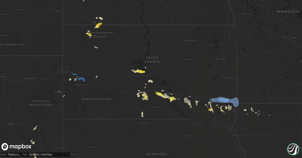
July 5 map
$229
one time, instant access
Download today. No call, no setup
Keep the $229
Bought the map and want the full workflow? Apply the entire $229 to a subscription within 7 days. None of it is wasted.
Every map, not just this one
This buys you this map. Subscription and you get every map we run, in the markets you choose from a few cities to whole states to nationwide. Plus real-time alerts the moment a storm fires.
Contact data
Name, contact info, occupancy, even credit band for addresses in the footprint. You go from where it hit to who to call.
Become the source they trust
Unlimited branding weather history reports on demand. You already have the documented answer ready for the property owner, and you are the one who showed up with it.
Property data and RoofTrace estimates
Pull up any address you have got, its value and the exact code rules for that jurisdiction, straight from One Click Code. Then RoofTrace estimates the squares, pitch, and roof value, priced the way you price.
Storm reports in South Dakota
South Dakota
| Date | Description |
|---|---|
| 07/05/20216:57 PM CDT | Report from mping: 1-inch tree limbs broken; shingles blown off. |
| 07/05/20216:57 PM CDT | Report from mping: 1-inch tree limbs broken; shingles blown off. |
| 07/05/20216:56 PM CDT | Trailer tipped over near i-90 mile marker 401 by wind gusts. No injuries reported. |
| 07/05/20216:55 PM CDT | Large portion of the rubber roofing damaged at the expo building on the w.h. Lyon fairgrounds. Time estimated from radar. |
| 07/05/20216:54 PM CDT | A local report indicates 65 MPH wind near 3 W SIOUX FALLS |
| 07/05/20216:40 PM CDT | Report from mping: 1-inch tree limbs broken; shingles blown off. |
| 07/05/20216:29 PM CDT | A local report indicates 70 MPH wind near 2 SE MONTROSE |
| 07/05/20216:25 PM CDT | A local report indicates 60 MPH wind near 1 SSE STURGIS |
| 07/05/20216:13 PM CDT | A local report indicates 1.00 inch wind near 11 NNW PRAIRIE CITY |
| 07/05/20216:03 PM CDT | A local report indicates 62 MPH wind near 8 W JEWEL CAVE |
| 07/05/20215:08 PM CDT | Some quarter sized hail... But mostly dime sized. Very heavy rain estimated at 2 inches so far. Wind gusts just before storm were estimated 60+... But nearly calm at mo |
| 07/05/20215:00 PM CDT | Irrigation pivot flipped over due to thunderstorm winds. |
| 07/05/20214:16 PM CDT | Mesonet station 201 gann valley |
| 07/05/20213:19 PM CDT | Most of the hail was pea sized... But some of the stones were as big as quarters. This was accompanied by very heavy rain. |
| 07/05/20212:45 PM CDT | Mesonet station 285 14w lower brule |
| 07/05/202112:15 PM CDT | A local report indicates 1.75 inch wind near 2 WNW CHANTLER CREEK RE |
| 07/05/20217:14 AM CDT | At 1214 PM CDT/1114 AM MDT/, a severe thunderstorm was located over southern Lake Oahe, or 14 miles northwest of Fort Pierre, moving east at 15 mph. HAZARD...60 mph wind gusts and quarter size hail. SOURCE...Radar indicated. IMPACT...Hail damage to vehicles is expected. Expect wind damage to roofs, siding, and trees. Locations impacted include... Oahe Mission Rec Area, Okobojo Point Rec Area, Spring Creek Rec Area, Cow Creek Rec Area, West Shore Rec Area and southern Lake Oahe. |
| 07/05/20212:20 AM CDT | Outbuilding collapsed. |
| 07/05/20211:15 AM CDT | At 614 PM CDT, a severe thunderstorm was located over Lake Vermillion State Recreation Area, moving east at 15 mph. HAZARD...60 mph wind gusts and penny size hail. SOURCE...Radar indicated. IMPACT...Expect damage to roofs, siding, and trees. This severe thunderstorm will be near... Humboldt around 640 PM CDT. Wall Lake around 650 PM CDT. Hartford around 700 PM CDT. |
| 07/05/20211:11 AM CDT | At 610 PM MDT, a severe thunderstorm was located 3 miles northwest of Viewfield, or 21 miles northeast of Rapid City, moving east at 50 mph. HAZARD...60 mph wind gusts. SOURCE...Radar indicated. IMPACT...Expect damage to roofs, siding, and trees. This severe thunderstorm will be near... Viewfield around 615 PM MDT. Curlew Lake around 620 PM MDT. Elm Springs around 630 PM MDT.Other locations in the path of this severe thunderstorm includeCreighton.This includes Interstate 90 in South Dakota between Mile Markers 69and 124. |
| 07/05/202112:19 AM CDT | At 519 PM MDT, severe thunderstorms were located along a line extending from 5 miles east of Vale to 2 miles southeast of Fort Meade to 4 miles north of Silver City, moving east at 30 mph. HAZARD...60 mph wind gusts and penny size hail. SOURCE...Radar indicated. IMPACT...Expect damage to roofs, siding, and trees. Severe thunderstorms will be near... Piedmont around 535 PM MDT.Other locations in the path of these severe thunderstorms includeSummerset, Black Hawk, Rapid City, Rapid Valley, Ellsworth Air ForceBase, Box Elder, Hereford and Rapid City Airport.This includes Interstate 90 in South Dakota between Mile Markers 26and 70. |
| 07/05/202112:12 AM CDT | At 512 PM MDT, a severe thunderstorm was located 8 miles north of Prairie City, or 27 miles southwest of Hettinger, moving southeast at 10 mph. HAZARD...Ping pong ball size hail and 60 mph wind gusts. SOURCE...Radar indicated. IMPACT...People and animals outdoors will be injured. Expect hail damage to roofs, siding, windows, and vehicles. Expect wind damage to roofs, siding, and trees. Locations impacted include... Prairie City. |
| 07/05/202112:00 AM CDT | At 500 PM CDT, a severe thunderstorm was located near Freeman, or 21 miles east of Parkston, moving east at 5 mph. HAZARD...60 mph wind gusts and half dollar size hail. SOURCE...Radar indicated. IMPACT...Hail damage to vehicles is expected. Expect wind damage to roofs, siding, and trees. This severe thunderstorm will be near... Freeman around 545 PM CDT. |
| 07/04/202111:54 PM CDT | At 453 PM MDT, a severe thunderstorm was located 5 miles northwest of Elk Mountain Lookout, or 6 miles southeast of Newcastle, moving northeast at 45 mph. HAZARD...60 mph wind gusts and nickel size hail. SOURCE...Radar indicated. IMPACT...Expect damage to roofs, siding, and trees. This severe thunderstorm will be near... Moon around 505 PM MDT. Redbank Spring Campground around 510 PM MDT.Other locations in the path of this severe thunderstorm include BearMountain Lookout. |
| 07/04/202110:17 PM CDT | At 317 PM CDT, a severe thunderstorm was located 8 miles northeast of Iona, or 10 miles south of Chamberlain, moving northeast at 5 mph. HAZARD...60 mph wind gusts and half dollar size hail. SOURCE...Radar indicated. IMPACT...Hail damage to vehicles is expected. Expect wind damage to roofs, siding, and trees. This severe thunderstorm will remain over mainly rural areas of southwestern Brule County. |
| 07/04/20219:30 PM CDT | At 229 PM CDT, a severe thunderstorm was located near Dude Ranch, or 10 miles southwest of Chamberlain, moving northeast at 5 mph. HAZARD...60 mph wind gusts and half dollar size hail. SOURCE...Radar indicated. IMPACT...Hail damage to vehicles is expected. Expect wind damage to roofs, siding, and trees. Locations impacted include... Lake Francis Case, Oacoma and Dude Ranch. |
| 07/04/20218:50 PM CDT | At 149 PM CDT, a severe thunderstorm was located 9 miles south of Reliance, or 16 miles west of Chamberlain, moving east at 10 mph. HAZARD...Ping pong ball size hail and 60 mph wind gusts. SOURCE...Radar indicated. IMPACT...People and animals outdoors will be injured. Expect hail damage to roofs, siding, windows, and vehicles. Expect wind damage to roofs, siding, and trees. Locations impacted include... Oacoma, Lake Francis Case and Dude Ranch. |
| 07/04/20217:25 PM CDT | A local report indicates 60 MPH wind near 8 SSW UNION CENTER |
| 07/04/20217:18 PM CDT | Report from mping: 3-inch tree limbs broken; power poles broken. |
| 07/04/20217:11 PM CDT | Report from mping: 1-inch tree limbs broken; shingles blown off. |
All States Impacted by Hail Map on July 5, 2021
Cities Impacted by Hail Map on July 5, 2021
- De Pere, WI
- Glen Ullin, ND
- Gladstone, ND
- Taylor, ND
- Hebron, ND
- Richardton, ND
- Douglas, WY
- Marinette, WI
- Peshtigo, WI
- Merrill, WI
- Wausau, WI
- Coopersville, MI
- Nunica, MI
- Porterfield, WI
- Lennox, SD
- Chancellor, SD
- Draper, SD
- Wood, SD
- Mora, NM
- Chamberlain, SD
- Pukwana, SD
- Okeechobee, FL
- Fort Pierre, SD
- Pierre, SD
- Hayes, SD
- Menno, SD
- Hartley, IA
- Primghar, IA
- Hudson, FL
- Chester, MT
- Newaygo, MI
- Howard City, MI
- Harrisville, MI
- Lincoln, MI
- Sanborn, IA
- Ashton, IA
- Sheldon, IA
- Crivitz, WI
- Greenbush, MI
- Mikado, MI
- Westcliffe, CO
- George, IA
- Kennebec, SD
- Reliance, SD
- Kimball, SD
- South Heart, ND
- Garden, MI
- Northport, MI
- Dubois, ID
- Meadow, SD
- Mott, ND
- Hettinger, ND
- Carrizozo, NM
- Freeman, SD
- Hull, IA
- Doon, IA
- Roscommon, MI
- Manistique, MI
- Presho, SD
- Rapid River, MI
- Pearsall, TX
- Dilley, TX
- Sturgis, SD
- Nemo, SD
- Piedmont, SD
- Lodgepole, SD
- Lemmon, SD
- Bridgewater, SD
- Emery, SD
- Cotulla, TX
- Olivet, SD
- Georgetown, CO
- Frederic, MI
- Kalkaska, MI
- Hurley, SD
- Red River, NM
- Black River, MI
- Dickens, IA
- Cooks, MI
- Barton City, MI
- Newcastle, WY
- Orlando, FL
- Ocoee, FL
- Willard, NM
- Plankinton, SD
- Wheatland, WY
- Beaver Island, MI
- Holabird, SD
- Montague, MA
- Wendell, MA
- Millers Falls, MA
- Stickney, SD
- Corsica, SD
- Rociada, NM
- Byers, CO
- White River, SD
- Murdo, SD
- Prairie City, SD
- Florissant, CO
- Belfield, ND
- Hondo, TX
- White Lake, SD
- Jeffrey City, WY
- Collins, MS
- Cornell, MI
- Gladstone, MI
- Waynesboro, MS
- Hamill, SD
- Kaukauna, WI
- Greenleaf, WI
- Wrightstown, WI
- Mission, SD
- Windermere, FL
- Harrisburg, SD
- Tea, SD
- Worthing, SD
- Sioux Falls, SD
- Canton, SD
- Oacoma, SD
- Empire, CO
- Idaho Springs, CO
- Garrett, WY
- Bison, SD
- Deadwood, SD
- Ossineke, MI
- Mount Vernon, SD
- Ethan, SD
- Egg Harbor, WI
- Reva, SD
- Naubinway, MI
- Parkston, SD
- Dimock, SD
- Lead, SD
- Spencer, IA
- West Winfield, NY
- Greene, IA
- Allison, IA
- Wasta, SD
- Fort Sumner, NM
- Gregory, SD
- Harrold, SD
- Marion, SD
- Fife Lake, MI
- Sheffield, IA
- Galata, MT
- Shelby, MT
- Lindon, CO
- Perkins, MI
- Rock, MI
- Pound, WI
- Spruce, MI
- Platte, SD
- Viborg, SD
- Parker, SD
- Davis, SD
- Garita, NM
- Harrison, SD
- Armour, SD
- Cochise, AZ
- Guffey, CO
- Vivian, SD
- Mountainair, NM
- Oconto, WI
- Mico, TX
- Dougherty, IA
- Centerville, SD
- Antigo, WI
- Little Suamico, WI
- Boyden, IA
- Kenansville, FL
- Coleman, WI
- Escanaba, MI
- Canistota, SD
- Beaver Creek, MN
- Valley Springs, SD
- Brandon, SD
- Hills, MN
- Crooks, SD
- Salem, SD
- Inwood, IA
- Garretson, SD
- Larchwood, IA
- Humboldt, SD
- Montrose, SD
- Hartford, SD
- Luverne, MN
- Fort Meade, SD
- Edgemont, SD
- Custer, SD
- Blackfoot, ID
- Riverton, WY
- Lander, WY
- Casper, WY


