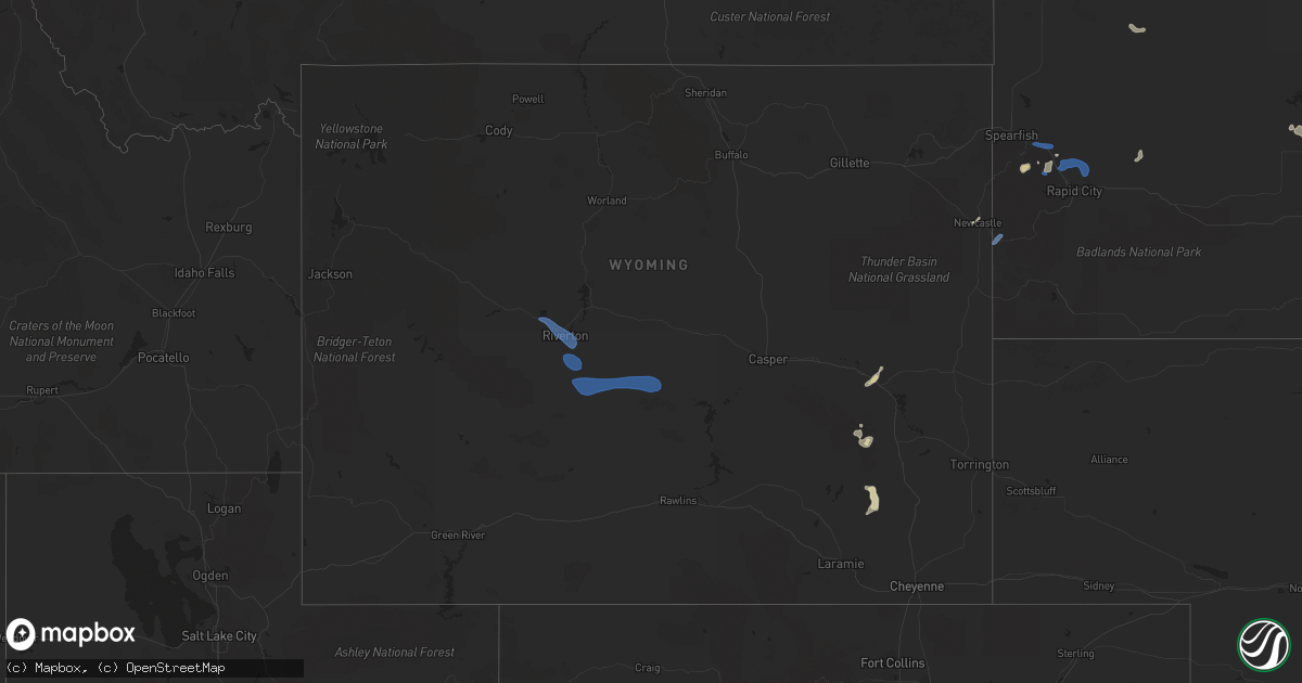
Hail Map in Wyoming on July 5, 2021
Get this storm
July 5 map
$229
one time, instant access
Download today. No call, no setup
Keep the $229
Bought the map and want the full workflow? Apply the entire $229 to a subscription within 7 days. None of it is wasted.
Every map, not just this one
This buys you this map. Subscription and you get every map we run, in the markets you choose from a few cities to whole states to nationwide. Plus real-time alerts the moment a storm fires.
Contact data
Name, contact info, occupancy, even credit band for addresses in the footprint. You go from where it hit to who to call.
Become the source they trust
Unlimited branding weather history reports on demand. You already have the documented answer ready for the property owner, and you are the one who showed up with it.
Property data and RoofTrace estimates
Pull up any address you have got, its value and the exact code rules for that jurisdiction, straight from One Click Code. Then RoofTrace estimates the squares, pitch, and roof value, priced the way you price.
Storm reports in Wyoming
Wyoming
| Date | Description |
|---|---|
| 07/05/20216:24 PM CDT | Asos station kriw riverton airport. |
| 07/05/20211:50 AM CDT | At 650 PM MDT, severe thunderstorms were located along a line extending from 6 miles west of Ervay to 13 miles northeast of Split Rock to 6 miles north of Muddy Gap, moving east at 30 mph. HAZARD...60 mph wind gusts and quarter size hail. SOURCE...Radar indicated. IMPACT...Hail damage to vehicles is expected. Expect wind damage to roofs, siding, and trees. Severe thunderstorms will be near... Ervay around 700 PM MDT. Devil's Gate around 710 PM MDT.Other locations in the path of these severe thunderstorms includeIndependence Rock. |
| 07/05/20211:12 AM CDT | At 612 PM MDT, severe thunderstorms were located along a line extending from 10 miles east of Battle Mountain to near Wheatland Reservoir 3 to 6 miles northwest of Bosler to 7 miles north of Lake Hattie Reservoir, moving east at 30 mph. HAZARD...60 mph wind gusts. SOURCE...Radar indicated. IMPACT...Expect damage to roofs, siding, and trees. Locations impacted include... Laramie, Rock River, Tie City Campground, North Crow Campground, Bosler, Baldy Peak, University Of Wyoming War Memorial Stadium, Garrett, Wheatland Reservoir 3, Vedauwoo Campground and Yellow Pine Campground.This includes Interstate 80 in Wyoming between mile markers 288 and329. |
| 07/05/202112:25 AM CDT | At 524 PM MDT, severe thunderstorms were located along a line extending from 7 miles northeast of Pavillion to near Hudson to 9 miles east of Red Canyon, moving east at 35 mph. HAZARD...60 mph wind gusts and nickel size hail. SOURCE...Radar indicated. IMPACT...Expect damage to roofs, siding, and trees. Severe thunderstorms will be near... Riverton and Arapahoe around 535 PM MDT.Other locations in the path of these severe thunderstorms includeSweetwater Station, Hidden Valley and Shoshoni. |
| 07/04/202110:21 PM CDT | At 320 PM MDT, severe thunderstorms were located along a line extending from 15 miles west of Bordeaux to 8 miles north of Iron Mountain, moving southeast at 25 mph. HAZARD...60 mph wind gusts and quarter size hail. SOURCE...Radar indicated. IMPACT...Hail damage to vehicles is expected. Expect wind damage to roofs, siding, and trees. These severe thunderstorms will remain over mainly rural areas of east central Albany, northwestern Laramie and southwestern Platte Counties. |
All States Impacted by Hail Map on July 5, 2021
Cities Impacted by Hail Map on July 5, 2021
- De Pere, WI
- Glen Ullin, ND
- Gladstone, ND
- Taylor, ND
- Hebron, ND
- Richardton, ND
- Douglas, WY
- Marinette, WI
- Peshtigo, WI
- Merrill, WI
- Wausau, WI
- Coopersville, MI
- Nunica, MI
- Porterfield, WI
- Lennox, SD
- Chancellor, SD
- Draper, SD
- Wood, SD
- Mora, NM
- Chamberlain, SD
- Pukwana, SD
- Okeechobee, FL
- Fort Pierre, SD
- Pierre, SD
- Hayes, SD
- Menno, SD
- Hartley, IA
- Primghar, IA
- Hudson, FL
- Chester, MT
- Newaygo, MI
- Howard City, MI
- Harrisville, MI
- Lincoln, MI
- Sanborn, IA
- Ashton, IA
- Sheldon, IA
- Crivitz, WI
- Greenbush, MI
- Mikado, MI
- Westcliffe, CO
- George, IA
- Kennebec, SD
- Reliance, SD
- Kimball, SD
- South Heart, ND
- Garden, MI
- Northport, MI
- Dubois, ID
- Meadow, SD
- Mott, ND
- Hettinger, ND
- Carrizozo, NM
- Freeman, SD
- Hull, IA
- Doon, IA
- Roscommon, MI
- Manistique, MI
- Presho, SD
- Rapid River, MI
- Pearsall, TX
- Dilley, TX
- Sturgis, SD
- Nemo, SD
- Piedmont, SD
- Lodgepole, SD
- Lemmon, SD
- Bridgewater, SD
- Emery, SD
- Cotulla, TX
- Olivet, SD
- Georgetown, CO
- Frederic, MI
- Kalkaska, MI
- Hurley, SD
- Red River, NM
- Black River, MI
- Dickens, IA
- Cooks, MI
- Barton City, MI
- Newcastle, WY
- Orlando, FL
- Ocoee, FL
- Willard, NM
- Plankinton, SD
- Wheatland, WY
- Beaver Island, MI
- Holabird, SD
- Montague, MA
- Wendell, MA
- Millers Falls, MA
- Stickney, SD
- Corsica, SD
- Rociada, NM
- Byers, CO
- White River, SD
- Murdo, SD
- Prairie City, SD
- Florissant, CO
- Belfield, ND
- Hondo, TX
- White Lake, SD
- Jeffrey City, WY
- Collins, MS
- Cornell, MI
- Gladstone, MI
- Waynesboro, MS
- Hamill, SD
- Kaukauna, WI
- Greenleaf, WI
- Wrightstown, WI
- Mission, SD
- Windermere, FL
- Harrisburg, SD
- Tea, SD
- Worthing, SD
- Sioux Falls, SD
- Canton, SD
- Oacoma, SD
- Empire, CO
- Idaho Springs, CO
- Garrett, WY
- Bison, SD
- Deadwood, SD
- Ossineke, MI
- Mount Vernon, SD
- Ethan, SD
- Egg Harbor, WI
- Reva, SD
- Naubinway, MI
- Parkston, SD
- Dimock, SD
- Lead, SD
- Spencer, IA
- West Winfield, NY
- Greene, IA
- Allison, IA
- Wasta, SD
- Fort Sumner, NM
- Gregory, SD
- Harrold, SD
- Marion, SD
- Fife Lake, MI
- Sheffield, IA
- Galata, MT
- Shelby, MT
- Lindon, CO
- Perkins, MI
- Rock, MI
- Pound, WI
- Spruce, MI
- Platte, SD
- Viborg, SD
- Parker, SD
- Davis, SD
- Garita, NM
- Harrison, SD
- Armour, SD
- Cochise, AZ
- Guffey, CO
- Vivian, SD
- Mountainair, NM
- Oconto, WI
- Mico, TX
- Dougherty, IA
- Centerville, SD
- Antigo, WI
- Little Suamico, WI
- Boyden, IA
- Kenansville, FL
- Coleman, WI
- Escanaba, MI
- Canistota, SD
- Beaver Creek, MN
- Valley Springs, SD
- Brandon, SD
- Hills, MN
- Crooks, SD
- Salem, SD
- Inwood, IA
- Garretson, SD
- Larchwood, IA
- Humboldt, SD
- Montrose, SD
- Hartford, SD
- Luverne, MN
- Fort Meade, SD
- Edgemont, SD
- Custer, SD
- Blackfoot, ID
- Riverton, WY
- Lander, WY
- Casper, WY


