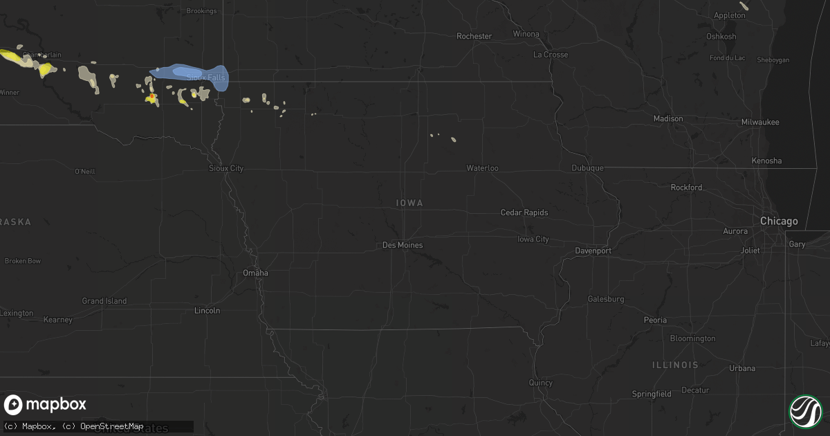
Hail Map in Iowa on July 5, 2021
Get this storm
July 5 map
$229
one time, instant access
Download today. No call, no setup
Keep the $229
Bought the map and want the full workflow? Apply the entire $229 to a subscription within 7 days. None of it is wasted.
Every map, not just this one
This buys you this map. Subscription and you get every map we run, in the markets you choose from a few cities to whole states to nationwide. Plus real-time alerts the moment a storm fires.
Contact data
Name, contact info, occupancy, even credit band for addresses in the footprint. You go from where it hit to who to call.
Become the source they trust
Unlimited branding weather history reports on demand. You already have the documented answer ready for the property owner, and you are the one who showed up with it.
Property data and RoofTrace estimates
Pull up any address you have got, its value and the exact code rules for that jurisdiction, straight from One Click Code. Then RoofTrace estimates the squares, pitch, and roof value, priced the way you price.
Storm reports in Iowa
Iowa
| Date | Description |
|---|---|
| 07/05/20213:24 AM CDT | At 823 PM CDT, a severe thunderstorm was located near Melvin, or 13 miles southeast of Sibley, moving east at 30 mph. HAZARD...60 mph wind gusts and penny size hail. SOURCE...Radar indicated. IMPACT...Expect damage to roofs, siding, and trees. This severe thunderstorm will be near... Hartley around 830 PM CDT. Everly around 845 PM CDT. Spencer In Clay County and Fostoria around 900 PM CDT.Other locations impacted by this severe thunderstorm include Dickens,Gillett Grove and Moneta. |
| 07/05/20212:57 AM CDT | At 756 PM CDT, a severe thunderstorm was located over Ashton, or near Sibley, moving east at 30 mph. HAZARD...60 mph wind gusts and penny size hail. SOURCE...Radar indicated. IMPACT...Expect damage to roofs, siding, and trees. This severe thunderstorm will be near... Sibley around 800 PM CDT. Melvin around 815 PM CDT. |
| 07/05/20212:16 AM CDT | At 716 PM CDT, severe thunderstorms were located along a line extending from near Trosky to 7 miles south of Luverne to near Alvord, moving east at 35 mph. HAZARD...70 mph wind gusts and penny size hail. SOURCE...Radar indicated. IMPACT...Expect considerable tree damage. Damage is likely to mobile homes, roofs, and outbuildings. Severe thunderstorms will be near... Rock Rapids around 720 PM CDT. Ellsworth around 730 PM CDT. George around 735 PM CDT. Adrian and Leota around 740 PM CDT. Little Rock and Lismore around 745 PM CDT. Rushmore around 750 PM CDT. Sibley, Ashton and Wilmont around 755 PM CDT.Other locations impacted by these severe thunderstorms includeKenneth, Steen, Magnolia and Bigelow. |
| 07/05/20211:37 AM CDT | At 637 PM CDT, severe thunderstorms were located along a line extending from near Dell Rapids to near Sioux Falls to near Brandon to near Lennox, moving east at 40 mph. HAZARD...60 mph wind gusts and penny size hail. SOURCE...Radar indicated. IMPACT...Expect damage to roofs, siding, and trees. Severe thunderstorms will be near... Brandon and Rowena around 645 PM CDT. Lake Alvin State Recreation Area and Palisades State Park around 650 PM CDT. Canton and Valley Springs around 655 PM CDT. Garretson, Hills, Beaver Creek and Sherman around 700 PM CDT. Larchwood, Inwood and Jasper around 705 PM CDT. Luverne and Lester around 710 PM CDT. Rock Rapids, Hardwick, Alvord and Blue Mounds State Park around 715 PM CDT.Other locations impacted by these severe thunderstorms includeMagnolia, Kenneth and Steen. |
| 07/04/20218:05 PM CDT | 6 to 8 inch diameter tree branches broken down by thunderstorm wind gusts. |
| 07/04/20218:03 PM CDT | Several branches estimated at 6 inches in diameter broken down by wind gusts. |
| 07/04/20217:40 PM CDT | A local report indicates 60 MPH wind near 3 WSW GEORGE |
All States Impacted by Hail Map on July 5, 2021
Cities Impacted by Hail Map on July 5, 2021
- De Pere, WI
- Glen Ullin, ND
- Gladstone, ND
- Taylor, ND
- Hebron, ND
- Richardton, ND
- Douglas, WY
- Marinette, WI
- Peshtigo, WI
- Merrill, WI
- Wausau, WI
- Coopersville, MI
- Nunica, MI
- Porterfield, WI
- Lennox, SD
- Chancellor, SD
- Draper, SD
- Wood, SD
- Mora, NM
- Chamberlain, SD
- Pukwana, SD
- Okeechobee, FL
- Fort Pierre, SD
- Pierre, SD
- Hayes, SD
- Menno, SD
- Hartley, IA
- Primghar, IA
- Hudson, FL
- Chester, MT
- Newaygo, MI
- Howard City, MI
- Harrisville, MI
- Lincoln, MI
- Sanborn, IA
- Ashton, IA
- Sheldon, IA
- Crivitz, WI
- Greenbush, MI
- Mikado, MI
- Westcliffe, CO
- George, IA
- Kennebec, SD
- Reliance, SD
- Kimball, SD
- South Heart, ND
- Garden, MI
- Northport, MI
- Dubois, ID
- Meadow, SD
- Mott, ND
- Hettinger, ND
- Carrizozo, NM
- Freeman, SD
- Hull, IA
- Doon, IA
- Roscommon, MI
- Manistique, MI
- Presho, SD
- Rapid River, MI
- Pearsall, TX
- Dilley, TX
- Sturgis, SD
- Nemo, SD
- Piedmont, SD
- Lodgepole, SD
- Lemmon, SD
- Bridgewater, SD
- Emery, SD
- Cotulla, TX
- Olivet, SD
- Georgetown, CO
- Frederic, MI
- Kalkaska, MI
- Hurley, SD
- Red River, NM
- Black River, MI
- Dickens, IA
- Cooks, MI
- Barton City, MI
- Newcastle, WY
- Orlando, FL
- Ocoee, FL
- Willard, NM
- Plankinton, SD
- Wheatland, WY
- Beaver Island, MI
- Holabird, SD
- Montague, MA
- Wendell, MA
- Millers Falls, MA
- Stickney, SD
- Corsica, SD
- Rociada, NM
- Byers, CO
- White River, SD
- Murdo, SD
- Prairie City, SD
- Florissant, CO
- Belfield, ND
- Hondo, TX
- White Lake, SD
- Jeffrey City, WY
- Collins, MS
- Cornell, MI
- Gladstone, MI
- Waynesboro, MS
- Hamill, SD
- Kaukauna, WI
- Greenleaf, WI
- Wrightstown, WI
- Mission, SD
- Windermere, FL
- Harrisburg, SD
- Tea, SD
- Worthing, SD
- Sioux Falls, SD
- Canton, SD
- Oacoma, SD
- Empire, CO
- Idaho Springs, CO
- Garrett, WY
- Bison, SD
- Deadwood, SD
- Ossineke, MI
- Mount Vernon, SD
- Ethan, SD
- Egg Harbor, WI
- Reva, SD
- Naubinway, MI
- Parkston, SD
- Dimock, SD
- Lead, SD
- Spencer, IA
- West Winfield, NY
- Greene, IA
- Allison, IA
- Wasta, SD
- Fort Sumner, NM
- Gregory, SD
- Harrold, SD
- Marion, SD
- Fife Lake, MI
- Sheffield, IA
- Galata, MT
- Shelby, MT
- Lindon, CO
- Perkins, MI
- Rock, MI
- Pound, WI
- Spruce, MI
- Platte, SD
- Viborg, SD
- Parker, SD
- Davis, SD
- Garita, NM
- Harrison, SD
- Armour, SD
- Cochise, AZ
- Guffey, CO
- Vivian, SD
- Mountainair, NM
- Oconto, WI
- Mico, TX
- Dougherty, IA
- Centerville, SD
- Antigo, WI
- Little Suamico, WI
- Boyden, IA
- Kenansville, FL
- Coleman, WI
- Escanaba, MI
- Canistota, SD
- Beaver Creek, MN
- Valley Springs, SD
- Brandon, SD
- Hills, MN
- Crooks, SD
- Salem, SD
- Inwood, IA
- Garretson, SD
- Larchwood, IA
- Humboldt, SD
- Montrose, SD
- Hartford, SD
- Luverne, MN
- Fort Meade, SD
- Edgemont, SD
- Custer, SD
- Blackfoot, ID
- Riverton, WY
- Lander, WY
- Casper, WY


