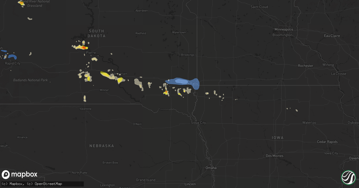
Hail Map on July 5, 2021
Get this storm
July 5 map
$229
one time, instant access
Download today. No call, no setup
Keep the $229
Bought the map and want the full workflow? Apply the entire $229 to a subscription within 7 days. None of it is wasted.
Every map, not just this one
This buys you this map. Subscription and you get every map we run, in the markets you choose from a few cities to whole states to nationwide. Plus real-time alerts the moment a storm fires.
Contact data
Name, contact info, occupancy, even credit band for addresses in the footprint. You go from where it hit to who to call.
Become the source they trust
Unlimited branding weather history reports on demand. You already have the documented answer ready for the property owner, and you are the one who showed up with it.
Property data and RoofTrace estimates
Pull up any address you have got, its value and the exact code rules for that jurisdiction, straight from One Click Code. Then RoofTrace estimates the squares, pitch, and roof value, priced the way you price.
States Impacted by Hail Map on July 5, 2021
Storm reports
Arizona
| Date | Description |
|---|---|
| 07/04/202111:32 PM CDT | At 431 PM MST, a severe thunderstorm was located near Pearce-Sunsites, or 17 miles south of Willcox, moving southeast at 10 mph. HAZARD...60 mph wind gusts and quarter size hail. SOURCE...Radar indicated. IMPACT...Hail damage to vehicles is expected. Expect wind damage to roofs, siding, and trees. Locations impacted include... Pearce-Sunsites.This includes Route 191 between mile markers 46 and 61. |
Idaho
| Date | Description |
|---|---|
| 07/05/20216:25 PM CDT | Mesonet station tab. |
| 07/05/202112:40 AM CDT | At 539 PM MDT, a severe thunderstorm was located near Rockford, or 12 miles west of Blackfoot, moving east at 25 mph. HAZARD...60 mph wind gusts and penny size hail. SOURCE...Radar and weather station indicated. A wind gust to 60 MPH was measured in Taber. IMPACT...Expect damage to roofs, siding, and trees. Locations impacted include... Blackfoot, Rockford, Moreland, Rose, Fort Hall Eagle Lodge, Pingree, Taber and Groveland. |
North Dakota
| Date | Description |
|---|---|
| 07/05/20216:53 PM CDT | Asos station khei hettinger airport. |
Kentucky
| Date | Description |
|---|---|
| 07/05/20211:08 AM CDT | At 607 PM EDT, a severe thunderstorm was located over Brazil, or near McKee, moving south at 10 mph. HAZARD...60 mph wind gusts. SOURCE...Radar indicated. IMPACT...Expect damage to roofs, siding, and trees. This severe thunderstorm will be near... Waneta around 620 PM EDT.Other locations in the path of this severe thunderstorm includeMcKee. |
Wisconsin
| Date | Description |
|---|---|
| 07/05/20216:43 PM CDT | Downed trees reported. Wind gusts measured 40 to 50 mph at wausau downtown airport. |
Mississippi
| Date | Description |
|---|---|
| 07/04/202111:25 PM CDT | At 425 PM CDT, a severe thunderstorm was located 5 miles west of Waynesboro, moving northwest at 25 mph. HAZARD...60 mph wind gusts and quarter size hail. SOURCE...Radar indicated. IMPACT...Hail damage to vehicles is expected. Expect wind damage to roofs, siding, and trees. Locations impacted include... Waynesboro and Clara. |
| 07/04/202110:11 PM CDT | At 311 PM CDT, a severe thunderstorm was located 5 miles west of Citronelle, moving west at 15 mph. HAZARD...60 mph wind gusts and penny size hail. SOURCE...Radar indicated. IMPACT...Expect damage to roofs, siding, and trees. Locations impacted include... Citronelle, Leakesville and Deer Park. |
Wyoming
| Date | Description |
|---|---|
| 07/05/20216:24 PM CDT | Asos station kriw riverton airport. |
| 07/05/20211:50 AM CDT | At 650 PM MDT, severe thunderstorms were located along a line extending from 6 miles west of Ervay to 13 miles northeast of Split Rock to 6 miles north of Muddy Gap, moving east at 30 mph. HAZARD...60 mph wind gusts and quarter size hail. SOURCE...Radar indicated. IMPACT...Hail damage to vehicles is expected. Expect wind damage to roofs, siding, and trees. Severe thunderstorms will be near... Ervay around 700 PM MDT. Devil's Gate around 710 PM MDT.Other locations in the path of these severe thunderstorms includeIndependence Rock. |
| 07/05/20211:12 AM CDT | At 612 PM MDT, severe thunderstorms were located along a line extending from 10 miles east of Battle Mountain to near Wheatland Reservoir 3 to 6 miles northwest of Bosler to 7 miles north of Lake Hattie Reservoir, moving east at 30 mph. HAZARD...60 mph wind gusts. SOURCE...Radar indicated. IMPACT...Expect damage to roofs, siding, and trees. Locations impacted include... Laramie, Rock River, Tie City Campground, North Crow Campground, Bosler, Baldy Peak, University Of Wyoming War Memorial Stadium, Garrett, Wheatland Reservoir 3, Vedauwoo Campground and Yellow Pine Campground.This includes Interstate 80 in Wyoming between mile markers 288 and329. |
| 07/05/202112:25 AM CDT | At 524 PM MDT, severe thunderstorms were located along a line extending from 7 miles northeast of Pavillion to near Hudson to 9 miles east of Red Canyon, moving east at 35 mph. HAZARD...60 mph wind gusts and nickel size hail. SOURCE...Radar indicated. IMPACT...Expect damage to roofs, siding, and trees. Severe thunderstorms will be near... Riverton and Arapahoe around 535 PM MDT.Other locations in the path of these severe thunderstorms includeSweetwater Station, Hidden Valley and Shoshoni. |
| 07/04/202110:21 PM CDT | At 320 PM MDT, severe thunderstorms were located along a line extending from 15 miles west of Bordeaux to 8 miles north of Iron Mountain, moving southeast at 25 mph. HAZARD...60 mph wind gusts and quarter size hail. SOURCE...Radar indicated. IMPACT...Hail damage to vehicles is expected. Expect wind damage to roofs, siding, and trees. These severe thunderstorms will remain over mainly rural areas of east central Albany, northwestern Laramie and southwestern Platte Counties. |
New York
| Date | Description |
|---|---|
| 07/05/20214:25 AM CDT | At 924 PM EDT, a severe thunderstorm was located 10 miles west of Cedar Point State Park, or 27 miles northwest of Watertown, moving east at 40 mph. HAZARD...60 mph wind gusts and penny size hail. SOURCE...Radar indicated. IMPACT...Expect damage to roofs, siding, and trees. Locations impacted include... Watertown, Fort Drum, West Carthage, Clayton, Dexter, Glen Park, Herrings, Redwood, Kring Point State Park and Wellesley Island State Park. This includes Interstate 81 between exits 46 and 52. |
| 07/04/202110:26 PM CDT | Large tree reported down on mulberry street in clinton. Time estimated by radar. |
| 07/04/20219:43 PM CDT | A local report indicates 1.00 inch wind near 1 E WESTMORELAND |
| 07/04/20218:55 PM CDT | 3 trees down over road. |
| 07/04/20218:55 PM CDT | Tree down over roadway. |
Iowa
| Date | Description |
|---|---|
| 07/05/20213:24 AM CDT | At 823 PM CDT, a severe thunderstorm was located near Melvin, or 13 miles southeast of Sibley, moving east at 30 mph. HAZARD...60 mph wind gusts and penny size hail. SOURCE...Radar indicated. IMPACT...Expect damage to roofs, siding, and trees. This severe thunderstorm will be near... Hartley around 830 PM CDT. Everly around 845 PM CDT. Spencer In Clay County and Fostoria around 900 PM CDT.Other locations impacted by this severe thunderstorm include Dickens,Gillett Grove and Moneta. |
| 07/05/20212:57 AM CDT | At 756 PM CDT, a severe thunderstorm was located over Ashton, or near Sibley, moving east at 30 mph. HAZARD...60 mph wind gusts and penny size hail. SOURCE...Radar indicated. IMPACT...Expect damage to roofs, siding, and trees. This severe thunderstorm will be near... Sibley around 800 PM CDT. Melvin around 815 PM CDT. |
| 07/05/20212:16 AM CDT | At 716 PM CDT, severe thunderstorms were located along a line extending from near Trosky to 7 miles south of Luverne to near Alvord, moving east at 35 mph. HAZARD...70 mph wind gusts and penny size hail. SOURCE...Radar indicated. IMPACT...Expect considerable tree damage. Damage is likely to mobile homes, roofs, and outbuildings. Severe thunderstorms will be near... Rock Rapids around 720 PM CDT. Ellsworth around 730 PM CDT. George around 735 PM CDT. Adrian and Leota around 740 PM CDT. Little Rock and Lismore around 745 PM CDT. Rushmore around 750 PM CDT. Sibley, Ashton and Wilmont around 755 PM CDT.Other locations impacted by these severe thunderstorms includeKenneth, Steen, Magnolia and Bigelow. |
| 07/05/20211:37 AM CDT | At 637 PM CDT, severe thunderstorms were located along a line extending from near Dell Rapids to near Sioux Falls to near Brandon to near Lennox, moving east at 40 mph. HAZARD...60 mph wind gusts and penny size hail. SOURCE...Radar indicated. IMPACT...Expect damage to roofs, siding, and trees. Severe thunderstorms will be near... Brandon and Rowena around 645 PM CDT. Lake Alvin State Recreation Area and Palisades State Park around 650 PM CDT. Canton and Valley Springs around 655 PM CDT. Garretson, Hills, Beaver Creek and Sherman around 700 PM CDT. Larchwood, Inwood and Jasper around 705 PM CDT. Luverne and Lester around 710 PM CDT. Rock Rapids, Hardwick, Alvord and Blue Mounds State Park around 715 PM CDT.Other locations impacted by these severe thunderstorms includeMagnolia, Kenneth and Steen. |
| 07/04/20218:05 PM CDT | 6 to 8 inch diameter tree branches broken down by thunderstorm wind gusts. |
| 07/04/20218:03 PM CDT | Several branches estimated at 6 inches in diameter broken down by wind gusts. |
| 07/04/20217:40 PM CDT | A local report indicates 60 MPH wind near 3 WSW GEORGE |
Texas
| Date | Description |
|---|---|
| 07/05/20217:59 AM CDT | At 1259 AM CDT, a severe thunderstorm was located 7 miles northeast of Claude, moving southwest at 20 mph. HAZARD...60 mph wind gusts and nickel size hail. SOURCE...Radar indicated. IMPACT...Minor damage to roofs, siding, and trees is possible. Locations impacted include... Claude and Washburn. |
| 07/05/20217:36 AM CDT | At 1236 AM CDT, a severe thunderstorm was located 5 miles northeast of Rhea, or 11 miles northwest of Friona, moving south at 25 mph. HAZARD...70 mph wind gusts and penny size hail. SOURCE...West Texas Mesonet at Bootleg reported a gust to 68 mph. IMPACT...Expect considerable tree damage. Damage is likely to mobile homes, roofs, and outbuildings. Locations impacted include... Friona, Bovina, Farwell, Oklahoma Lane, Black and Rhea. |
| 07/05/20217:24 AM CDT | At 1223 AM MDT, severe thunderstorms were located along a line extending from 19 miles south of Fort Sumner to 9 miles north of Elida to near West Camp, moving south at 35 mph. HAZARD...70 mph wind gusts. SOURCE...Radar indicated. IMPACT...Expect considerable tree damage. Damage is likely to mobile homes, roofs, and outbuildings. Locations impacted include... Portales, Farwell, Elida, Dora, Floyd, Causey, Milnesand, Elkins, Arch and Oasis State Park. |
| 07/05/20217:01 AM CDT | At 1201 AM CDT, a severe thunderstorm was located 8 miles north of Groom, or 16 miles south of Pampa, moving southwest at 20 mph. HAZARD...60 mph wind gusts and half dollar size hail. SOURCE...Radar indicated. IMPACT...Minor damage to roofs, siding, and trees is possible. Hail damage to vehicles is expected. Locations impacted include... Pampa, Groom, Lefors and Kingsmill. |
| 07/05/20215:11 AM CDT | At 1011 PM CDT, a severe thunderstorm was located 14 miles west of La Esperanza Ranch Airport, or 27 miles west of Encinal, moving east at 15 mph. HAZARD...60 mph wind gusts and quarter size hail. SOURCE...Radar indicated. IMPACT...Hail damage to vehicles is expected. Expect wind damage to roofs, siding, and trees. Locations impacted include... Las Tiendas and La Esperanza Ranch Airport. This includes US Highway 83 between mile markers 670 and 676. |
| 07/05/20212:12 AM CDT | At 712 PM CDT, a severe thunderstorm was located near Dilley, moving south at 10 mph. HAZARD...Quarter size hail. SOURCE...Radar indicated. IMPACT...Damage to vehicles is expected. Locations impacted include... Cotulla, Millett, Los Angeles and Gardendale. This includes Interstate 35 between mile markers 66 and 82. |
| 07/04/202110:53 PM CDT | At 352 AM CDT, a severe thunderstorm was located 5 miles southwest of Whitharral, or 7 miles north of Levelland, moving south at 15 mph. HAZARD...60 mph wind gusts and penny size hail. SOURCE...Radar indicated. IMPACT...Expect damage to roofs, siding, and trees. Locations impacted include... Levelland, Sundown, Whitharral, Smyer and Opdyke West. |
| 07/04/202110:00 PM CDT | At 300 AM MDT, severe thunderstorms were located along a line extending from 7 miles northeast of Hobbs to 6 miles west of Monument to 22 miles east of Carlsbad North to 7 miles south of Artesia to 10 miles northeast of Hope, moving south at 35 mph. HAZARD...60 mph wind gusts and nickel size hail. SOURCE...Radar indicated. IMPACT...Expect damage to roofs, siding, and trees. Locations impacted include... Hobbs, Carlsbad, Artesia, Lovington, Eunice, Loving, Monument, Humble City, Avalon, Maljamar, Eunice Airport, Seven Rivers Airport, Nadine, Brantley Lake State Park, Carlsbad North, Malaga, Loco Hills, Otis, Dayton and Halfway. |
| 07/04/20219:48 PM CDT | At 248 AM CDT, a severe thunderstorm was located near Enochs, or 10 miles north of Morton, moving south at 20 mph. HAZARD...60 mph wind gusts and quarter size hail. SOURCE...Radar indicated. IMPACT...Hail damage to vehicles is expected. Expect wind damage to roofs, siding, and trees. Locations impacted include... Morton, Muleshoe Wildlife Refuge, Bula, Enochs, Pep, Lehman and Whiteface. |
| 07/04/20218:31 PM CDT | At 131 AM CDT, a severe thunderstorm was located over Washburn, or 13 miles northwest of Claude, moving west at 20 mph. HAZARD...70 mph wind gusts and ping pong ball size hail. SOURCE...Radar indicated. IMPACT...Expect some tree damage. Damage is likely to mobile homes, roofs, and outbuildings. People and animals outdoors will be injured. Expect hail damage to roofs, siding, windows, and vehicles. Locations impacted include... Amarillo, Canyon, Claude, Lake Tanglewood, Mescalero Park, Washburn and Timbercreek Canyon. |
South Dakota
| Date | Description |
|---|---|
| 07/05/20216:57 PM CDT | Report from mping: 1-inch tree limbs broken; shingles blown off. |
| 07/05/20216:57 PM CDT | Report from mping: 1-inch tree limbs broken; shingles blown off. |
| 07/05/20216:56 PM CDT | Trailer tipped over near i-90 mile marker 401 by wind gusts. No injuries reported. |
| 07/05/20216:55 PM CDT | Large portion of the rubber roofing damaged at the expo building on the w.h. Lyon fairgrounds. Time estimated from radar. |
| 07/05/20216:54 PM CDT | A local report indicates 65 MPH wind near 3 W SIOUX FALLS |
| 07/05/20216:40 PM CDT | Report from mping: 1-inch tree limbs broken; shingles blown off. |
| 07/05/20216:29 PM CDT | A local report indicates 70 MPH wind near 2 SE MONTROSE |
| 07/05/20216:25 PM CDT | A local report indicates 60 MPH wind near 1 SSE STURGIS |
| 07/05/20216:13 PM CDT | A local report indicates 1.00 inch wind near 11 NNW PRAIRIE CITY |
| 07/05/20216:03 PM CDT | A local report indicates 62 MPH wind near 8 W JEWEL CAVE |
| 07/05/20215:08 PM CDT | Some quarter sized hail... But mostly dime sized. Very heavy rain estimated at 2 inches so far. Wind gusts just before storm were estimated 60+... But nearly calm at mo |
| 07/05/20215:00 PM CDT | Irrigation pivot flipped over due to thunderstorm winds. |
| 07/05/20214:16 PM CDT | Mesonet station 201 gann valley |
| 07/05/20213:19 PM CDT | Most of the hail was pea sized... But some of the stones were as big as quarters. This was accompanied by very heavy rain. |
| 07/05/20212:45 PM CDT | Mesonet station 285 14w lower brule |
| 07/05/202112:15 PM CDT | A local report indicates 1.75 inch wind near 2 WNW CHANTLER CREEK RE |
| 07/05/20217:14 AM CDT | At 1214 PM CDT/1114 AM MDT/, a severe thunderstorm was located over southern Lake Oahe, or 14 miles northwest of Fort Pierre, moving east at 15 mph. HAZARD...60 mph wind gusts and quarter size hail. SOURCE...Radar indicated. IMPACT...Hail damage to vehicles is expected. Expect wind damage to roofs, siding, and trees. Locations impacted include... Oahe Mission Rec Area, Okobojo Point Rec Area, Spring Creek Rec Area, Cow Creek Rec Area, West Shore Rec Area and southern Lake Oahe. |
| 07/05/20212:20 AM CDT | Outbuilding collapsed. |
| 07/05/20211:15 AM CDT | At 614 PM CDT, a severe thunderstorm was located over Lake Vermillion State Recreation Area, moving east at 15 mph. HAZARD...60 mph wind gusts and penny size hail. SOURCE...Radar indicated. IMPACT...Expect damage to roofs, siding, and trees. This severe thunderstorm will be near... Humboldt around 640 PM CDT. Wall Lake around 650 PM CDT. Hartford around 700 PM CDT. |
| 07/05/20211:11 AM CDT | At 610 PM MDT, a severe thunderstorm was located 3 miles northwest of Viewfield, or 21 miles northeast of Rapid City, moving east at 50 mph. HAZARD...60 mph wind gusts. SOURCE...Radar indicated. IMPACT...Expect damage to roofs, siding, and trees. This severe thunderstorm will be near... Viewfield around 615 PM MDT. Curlew Lake around 620 PM MDT. Elm Springs around 630 PM MDT.Other locations in the path of this severe thunderstorm includeCreighton.This includes Interstate 90 in South Dakota between Mile Markers 69and 124. |
| 07/05/202112:19 AM CDT | At 519 PM MDT, severe thunderstorms were located along a line extending from 5 miles east of Vale to 2 miles southeast of Fort Meade to 4 miles north of Silver City, moving east at 30 mph. HAZARD...60 mph wind gusts and penny size hail. SOURCE...Radar indicated. IMPACT...Expect damage to roofs, siding, and trees. Severe thunderstorms will be near... Piedmont around 535 PM MDT.Other locations in the path of these severe thunderstorms includeSummerset, Black Hawk, Rapid City, Rapid Valley, Ellsworth Air ForceBase, Box Elder, Hereford and Rapid City Airport.This includes Interstate 90 in South Dakota between Mile Markers 26and 70. |
| 07/05/202112:12 AM CDT | At 512 PM MDT, a severe thunderstorm was located 8 miles north of Prairie City, or 27 miles southwest of Hettinger, moving southeast at 10 mph. HAZARD...Ping pong ball size hail and 60 mph wind gusts. SOURCE...Radar indicated. IMPACT...People and animals outdoors will be injured. Expect hail damage to roofs, siding, windows, and vehicles. Expect wind damage to roofs, siding, and trees. Locations impacted include... Prairie City. |
| 07/05/202112:00 AM CDT | At 500 PM CDT, a severe thunderstorm was located near Freeman, or 21 miles east of Parkston, moving east at 5 mph. HAZARD...60 mph wind gusts and half dollar size hail. SOURCE...Radar indicated. IMPACT...Hail damage to vehicles is expected. Expect wind damage to roofs, siding, and trees. This severe thunderstorm will be near... Freeman around 545 PM CDT. |
| 07/04/202111:54 PM CDT | At 453 PM MDT, a severe thunderstorm was located 5 miles northwest of Elk Mountain Lookout, or 6 miles southeast of Newcastle, moving northeast at 45 mph. HAZARD...60 mph wind gusts and nickel size hail. SOURCE...Radar indicated. IMPACT...Expect damage to roofs, siding, and trees. This severe thunderstorm will be near... Moon around 505 PM MDT. Redbank Spring Campground around 510 PM MDT.Other locations in the path of this severe thunderstorm include BearMountain Lookout. |
| 07/04/202110:17 PM CDT | At 317 PM CDT, a severe thunderstorm was located 8 miles northeast of Iona, or 10 miles south of Chamberlain, moving northeast at 5 mph. HAZARD...60 mph wind gusts and half dollar size hail. SOURCE...Radar indicated. IMPACT...Hail damage to vehicles is expected. Expect wind damage to roofs, siding, and trees. This severe thunderstorm will remain over mainly rural areas of southwestern Brule County. |
| 07/04/20219:30 PM CDT | At 229 PM CDT, a severe thunderstorm was located near Dude Ranch, or 10 miles southwest of Chamberlain, moving northeast at 5 mph. HAZARD...60 mph wind gusts and half dollar size hail. SOURCE...Radar indicated. IMPACT...Hail damage to vehicles is expected. Expect wind damage to roofs, siding, and trees. Locations impacted include... Lake Francis Case, Oacoma and Dude Ranch. |
| 07/04/20218:50 PM CDT | At 149 PM CDT, a severe thunderstorm was located 9 miles south of Reliance, or 16 miles west of Chamberlain, moving east at 10 mph. HAZARD...Ping pong ball size hail and 60 mph wind gusts. SOURCE...Radar indicated. IMPACT...People and animals outdoors will be injured. Expect hail damage to roofs, siding, windows, and vehicles. Expect wind damage to roofs, siding, and trees. Locations impacted include... Oacoma, Lake Francis Case and Dude Ranch. |
| 07/04/20217:25 PM CDT | A local report indicates 60 MPH wind near 8 SSW UNION CENTER |
| 07/04/20217:18 PM CDT | Report from mping: 3-inch tree limbs broken; power poles broken. |
| 07/04/20217:11 PM CDT | Report from mping: 1-inch tree limbs broken; shingles blown off. |
Florida
| Date | Description |
|---|---|
| 07/04/202110:38 PM CDT | At 338 PM EDT, a severe thunderstorm was located 11 miles southeast of Golden Gate Estates, moving northwest at 25 mph. HAZARD...60 mph wind gusts and nickel size hail. SOURCE...Radar indicated. IMPACT...Expect damage to roofs, siding, and trees. Locations impacted include... Ave Maria, Golden Gate Estates, Immokalee, Orangetree and Big Corkscrew Island. |
| 07/04/202110:08 PM CDT | At 307 PM EDT, severe thunderstorms were located along a line extending from 16 miles east of Key Biscayne to 9 miles east of Black Point, moving north at 30 mph. HAZARD...60 mph wind gusts. SOURCE...Radar indicated. IMPACT...Expect damage to roofs, siding, and trees. Locations impacted include... Miami, Hialeah, Miami Beach, Coral Gables and Key Biscayne. |
Colorado
| Date | Description |
|---|---|
| 07/05/20216:44 PM CDT | Kbkf. |
| 07/04/202111:34 PM CDT | At 433 PM MDT, a severe thunderstorm was located near Crestone Peak, or 19 miles southeast of Hayden Pass Burn Scar, and is nearly stationary. HAZARD...60 mph wind gusts and quarter size hail. SOURCE...Radar indicated. IMPACT...Hail damage to vehicles is expected. Expect wind damage to roofs, siding, and trees. Locations impacted include... Crestone Peak, Silver Cliff and Westcliffe. |
| 07/04/20219:51 PM CDT | At 248 PM MDT, a severe thunderstorm was located near Florissant, or 23 miles west of Colorado Springs, moving east at 15 mph. HAZARD...60 mph wind gusts and quarter size hail. SOURCE...Radar indicated. IMPACT...Hail damage to vehicles is expected. Expect wind damage to roofs, siding, and trees. Locations impacted include... Cripple Creek, Florissant and Divide. |
Montana
| Date | Description |
|---|---|
| 07/05/20215:25 AM CDT | At 1024 PM MDT, a severe thunderstorm was located 16 miles west of Sunburst, or 20 miles north of Cut Bank, moving southeast at 35 mph. HAZARD...70 mph wind gusts and quarter size hail. SOURCE...Radar indicated. IMPACT...Hail damage to vehicles is expected. Expect considerable tree damage. Wind damage is also likely to mobile homes, roofs, and outbuildings. Locations impacted include... Shelby, Cut Bank, Sunburst, Kevin, Sweet Grass, Ethridge, Oilmont, Santa Rita and Ferdig. |
| 07/05/20214:57 AM CDT | At 956 PM MDT, a severe thunderstorm was located 26 miles northwest of Cut Bank, moving southeast at 30 mph. HAZARD...60 mph wind gusts and quarter size hail. SOURCE...Radar indicated. IMPACT...Hail damage to vehicles is expected. Expect wind damage to roofs, siding, and trees. Locations impacted include... Santa Rita. |
Michigan
| Date | Description |
|---|---|
| 07/05/20216:30 PM CDT | Pictures of multiple trees down in the village. Time estimated via radar. |
| 07/05/20213:34 AM CDT | At 834 PM EDT, a severe thunderstorm was located over Black River, or 9 miles southeast of Ossineke, moving east at 30 mph. HAZARD...60 mph wind gusts and quarter size hail. SOURCE...Radar indicated. IMPACT...Hail damage to vehicles is expected. Expect wind damage to roofs, siding, and trees. This severe thunderstorm will be near... Black River around 840 PM EDT. |
| 07/05/20211:32 AM CDT | At 632 PM EDT, a severe thunderstorm was located 8 miles northwest of Escanaba, moving southeast at 20 mph. HAZARD...Quarter size hail. SOURCE...Radar indicated. IMPACT...Damage to vehicles is expected. This severe thunderstorm will be near... Gladstone around 645 PM EDT. Escanaba around 650 PM EDT. |
| 07/04/202110:15 PM CDT | At 313 PM EDT, a severe thunderstorm was located over Gladstone, or near Escanaba, moving southeast at 25 mph. HAZARD...60 mph wind gusts and quarter size hail. SOURCE...Radar indicated. IMPACT...Hail damage to vehicles is expected. Expect wind damage to roofs, siding, and trees. This severe thunderstorm will remain over mainly rural areas of central Delta County, including the following locations... Stonington. |
| 07/04/202110:01 PM CDT | At 300 PM EDT, a severe thunderstorm was located near Gladstone, or 11 miles north of Escanaba, moving southeast at 20 mph. HAZARD...Quarter size hail. SOURCE...Radar indicated. IMPACT...Damage to vehicles is expected. This severe thunderstorm will be near... Rapid River around 310 PM EDT. Gladstone around 315 PM EDT. |
| 07/04/20219:43 PM CDT | At 243 PM EDT, a severe thunderstorm was located over Lincoln, or near Harrisville, moving east at 30 mph. HAZARD...60 mph wind gusts and quarter size hail. SOURCE...Radar indicated. IMPACT...Hail damage to vehicles is expected. Expect wind damage to roofs, siding, and trees. This severe thunderstorm will be near... Harrisville and Harrisville State Park around 255 PM EDT. |
| 07/04/20217:35 PM CDT | At least five 12-18 size trees are down on the property due to strong winds. Minor damage to one building as one tree fell against it. |
New Mexico
| Date | Description |
|---|---|
| 07/05/202110:24 AM CDT | Small tree limbs generally less than 1 inch diameter knocked down. |
Cities Impacted by Hail Map on July 5, 2021
- De Pere, WI
- Glen Ullin, ND
- Gladstone, ND
- Taylor, ND
- Hebron, ND
- Richardton, ND
- Douglas, WY
- Marinette, WI
- Peshtigo, WI
- Merrill, WI
- Wausau, WI
- Coopersville, MI
- Nunica, MI
- Porterfield, WI
- Lennox, SD
- Chancellor, SD
- Draper, SD
- Wood, SD
- Mora, NM
- Chamberlain, SD
- Pukwana, SD
- Okeechobee, FL
- Fort Pierre, SD
- Pierre, SD
- Hayes, SD
- Menno, SD
- Hartley, IA
- Primghar, IA
- Hudson, FL
- Chester, MT
- Newaygo, MI
- Howard City, MI
- Harrisville, MI
- Lincoln, MI
- Sanborn, IA
- Ashton, IA
- Sheldon, IA
- Crivitz, WI
- Greenbush, MI
- Mikado, MI
- Westcliffe, CO
- George, IA
- Kennebec, SD
- Reliance, SD
- Kimball, SD
- South Heart, ND
- Garden, MI
- Northport, MI
- Dubois, ID
- Meadow, SD
- Mott, ND
- Hettinger, ND
- Carrizozo, NM
- Freeman, SD
- Hull, IA
- Doon, IA
- Roscommon, MI
- Manistique, MI
- Presho, SD
- Rapid River, MI
- Pearsall, TX
- Dilley, TX
- Sturgis, SD
- Nemo, SD
- Piedmont, SD
- Lodgepole, SD
- Lemmon, SD
- Bridgewater, SD
- Emery, SD
- Cotulla, TX
- Olivet, SD
- Georgetown, CO
- Frederic, MI
- Kalkaska, MI
- Hurley, SD
- Red River, NM
- Black River, MI
- Dickens, IA
- Cooks, MI
- Barton City, MI
- Newcastle, WY
- Orlando, FL
- Ocoee, FL
- Willard, NM
- Plankinton, SD
- Wheatland, WY
- Beaver Island, MI
- Holabird, SD
- Montague, MA
- Wendell, MA
- Millers Falls, MA
- Stickney, SD
- Corsica, SD
- Rociada, NM
- Byers, CO
- White River, SD
- Murdo, SD
- Prairie City, SD
- Florissant, CO
- Belfield, ND
- Hondo, TX
- White Lake, SD
- Jeffrey City, WY
- Collins, MS
- Cornell, MI
- Gladstone, MI
- Waynesboro, MS
- Hamill, SD
- Kaukauna, WI
- Greenleaf, WI
- Wrightstown, WI
- Mission, SD
- Windermere, FL
- Harrisburg, SD
- Tea, SD
- Worthing, SD
- Sioux Falls, SD
- Canton, SD
- Oacoma, SD
- Empire, CO
- Idaho Springs, CO
- Garrett, WY
- Bison, SD
- Deadwood, SD
- Ossineke, MI
- Mount Vernon, SD
- Ethan, SD
- Egg Harbor, WI
- Reva, SD
- Naubinway, MI
- Parkston, SD
- Dimock, SD
- Lead, SD
- Spencer, IA
- West Winfield, NY
- Greene, IA
- Allison, IA
- Wasta, SD
- Fort Sumner, NM
- Gregory, SD
- Harrold, SD
- Marion, SD
- Fife Lake, MI
- Sheffield, IA
- Galata, MT
- Shelby, MT
- Lindon, CO
- Perkins, MI
- Rock, MI
- Pound, WI
- Spruce, MI
- Platte, SD
- Viborg, SD
- Parker, SD
- Davis, SD
- Garita, NM
- Harrison, SD
- Armour, SD
- Cochise, AZ
- Guffey, CO
- Vivian, SD
- Mountainair, NM
- Oconto, WI
- Mico, TX
- Dougherty, IA
- Centerville, SD
- Antigo, WI
- Little Suamico, WI
- Boyden, IA
- Kenansville, FL
- Coleman, WI
- Escanaba, MI
- Canistota, SD
- Beaver Creek, MN
- Valley Springs, SD
- Brandon, SD
- Hills, MN
- Crooks, SD
- Salem, SD
- Inwood, IA
- Garretson, SD
- Larchwood, IA
- Humboldt, SD
- Montrose, SD
- Hartford, SD
- Luverne, MN
- Fort Meade, SD
- Edgemont, SD
- Custer, SD
- Blackfoot, ID
- Riverton, WY
- Lander, WY
- Casper, WY