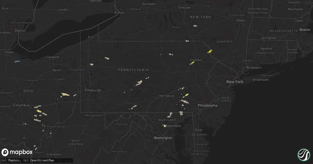
Hail Map in Pennsylvania on July 1, 2022
Get this storm
July 1 map
$229
one time, instant access
Download today. No call, no setup
Keep the $229
Bought the map and want the full workflow? Apply the entire $229 to a subscription within 7 days. None of it is wasted.
Every map, not just this one
This buys you this map. Subscription and you get every map we run, in the markets you choose from a few cities to whole states to nationwide. Plus real-time alerts the moment a storm fires.
Contact data
Name, contact info, occupancy, even credit band for addresses in the footprint. You go from where it hit to who to call.
Become the source they trust
Unlimited branding weather history reports on demand. You already have the documented answer ready for the property owner, and you are the one who showed up with it.
Property data and RoofTrace estimates
Pull up any address you have got, its value and the exact code rules for that jurisdiction, straight from One Click Code. Then RoofTrace estimates the squares, pitch, and roof value, priced the way you price.
Storm reports in Pennsylvania
Pennsylvania
| Date | Description |
|---|---|
| 07/01/20224:46 PM CDT | Multiple trees down. Time estimated via radar. |
| 07/01/20224:45 PM CDT | Tree down on a house on amelia road. |
| 07/01/20224:37 PM CDT | A local report indicates 1.00 inch wind near AVOCA |
| 07/01/20224:37 PM CDT | A local report indicates 1.00 inch wind near OLD FORGE |
| 07/01/20223:45 PM CDT | Trees down on wires along pine creek drive. |
| 07/01/20223:24 PM CDT | Moderate-sized tree branches and limbs down along good hope road between route 896 and flint hill road. Time estimated via radar. |
| 07/01/20222:40 PM CDT | Trees down on wires. |
| 07/01/20222:12 PM CDT | Trees down on wires near green springs road. |
| 07/01/20222:10 PM CDT | Trees down on wires along route 472. |
| 07/01/20222:02 PM CDT | Trees down on wires across barrens road. |
| 07/01/20221:53 PM CDT | Numerous trees and wires down in the manor ridge area. |
| 07/01/20221:41 PM CDT | Trees down on wires at the intersection of compass road and hill road. Time estimated via radar. |
| 07/01/20221:20 PM CDT | Several medium size limbs and 1 medium size tree down. |
| 07/01/20221:18 PM CDT | Trees down on wires. |
| 07/01/20221:15 PM CDT | Tree toppled on wires on charles street. |
| 07/01/20221:10 PM CDT | Picture via social media with an estimated size given. Time estimated via radar. |
| 07/01/20221:09 PM CDT | Multiple trees/wires down reported in reading/wyomissing/spring twp area via em. Time estimated via radar. |
| 07/01/20221:08 PM CDT | 1 inch hail reported in west wyomissing/spring township. Time estimated via radar. |
| 07/01/20221:07 PM CDT | Ppl outage center reports trees down on wires in this neighborhood. Time estimated via radar. |
| 07/01/20221:06 PM CDT | Report from trained spotter of pea to quarter sized hail. Time estimated via radar. |
| 07/01/20221:06 PM CDT | Time estimated via radar. |
| 07/01/20221:00 PM CDT | One tree snapped with a large limb landing on the roof of a house on the 2600 block of stoverstown rd. |
| 07/01/202212:55 PM CDT | Tree damage intersection of pa-45 and pa-350 via social media. |
| 07/01/202212:53 PM CDT | Trees and wires down in franklin twp near warriors mark. |
| 07/01/202212:30 PM CDT | Trees down in tyrone twp. |
| 07/01/202212:26 PM CDT | Trees and wires down on bellmeade drive. |
| 07/01/202212:21 PM CDT | Several trees down along kettle road. Power poles snapped near blackie lane. |
| 07/01/202212:15 PM CDT | Trees down in allegheny twp/sugar run rd. |
| 07/01/202212:06 PM CDT | Multiple trees and wires down along old route 22. |
| 07/01/20226:18 AM CDT | At 1118 PM EDT, a severe thunderstorm was located near Jeffries, moving east at 40 mph. HAZARD...60 mph wind gusts. SOURCE...Radar indicated. IMPACT...Expect damage to roofs, siding, and trees. Locations impacted include... Philipsburg, Curwensville, Osceola Mills, Chester Hill, Houtzdale, Jeffries, Morrisdale, Irvona, West Decatur, Coalport, Ramey and Brisbin. |
| 07/01/20225:05 AM CDT | At 1005 PM EDT, severe thunderstorms were located along a line extending from near Vestal Center to Brackney, moving east at 20 mph. HAZARD...60 mph wind gusts and quarter size hail. SOURCE...Radar indicated. IMPACT...Hail damage to vehicles is expected. Expect wind damage to roofs, siding, and trees. Locations impacted include... Kirkwood, Conklin, Great Bend and Brackney. |
| 07/01/20224:27 AM CDT | At 927 PM EDT, a severe thunderstorm was located over Vestal Center, or near Binghamton, moving east at 30 mph. HAZARD...60 mph wind gusts and quarter size hail. SOURCE...Radar indicated. IMPACT...Hail damage to vehicles is expected. Expect wind damage to roofs, siding, and trees. Locations impacted include... Binghamton, Kirkwood, Conklin, Susquehanna, Susquehanna Depot, Hallstead, Windsor, New Milford, Great Bend and Lanesboro. |
| 07/01/20224:20 AM CDT | At 919 PM EDT, severe thunderstorms were located along a line extending from Stamford to near Sanford, moving southeast at 30 mph. HAZARD...60 mph wind gusts and quarter size hail. SOURCE...Radar indicated. IMPACT...Hail damage to vehicles is expected. Expect wind damage to roofs, siding, and trees. Locations impacted include... Rockland, Oneonta, Sidney, Walton, Delhi, Davenport, Roxbury, Sanford, Colchester and Maryland. |
| 07/01/20223:50 AM CDT | At 849 PM EDT, severe thunderstorms were located along a line extending from Colliersville to near Bainbridge, moving southeast at 25 mph. HAZARD...60 mph wind gusts and quarter size hail. SOURCE...Radar indicated. IMPACT...Hail damage to vehicles is expected. Expect wind damage to roofs, siding, and trees. Locations impacted include... Oneonta, Sidney, Walton, Delhi, Davenport, Guilford, Sanford, Colchester, Maryland and Kortright. |
| 07/01/20223:48 AM CDT | At 848 PM EDT, a severe thunderstorm was located near Shunk, or 9 miles southeast of Canton, moving east at 15 mph. HAZARD...60 mph wind gusts and quarter size hail. SOURCE...Radar indicated. IMPACT...Hail damage to vehicles is expected. Expect wind damage to roofs, siding, and trees. Locations impacted include... Canton, West Franklin, Wilmot, Hollenback, Wyalusing, Monroe, New Albany, Overton, Monroeton and Sugar Run. |
| 07/01/20221:50 AM CDT | At 650 PM EDT, a severe thunderstorm was located over Fosterdale, or 12 miles southwest of Liberty, moving northeast at 35 mph. HAZARD...60 mph wind gusts and half dollar size hail. SOURCE...Radar indicated. IMPACT...Hail damage to vehicles is expected. Expect wind damage to roofs, siding, and trees. Locations impacted include... Liberty, Bethel, Neversink, South Fallsburg, Cochecton, Jeffersonville, Parksville, Swan Lake, Loch Sheldrake and Hurleyville. |
| 07/01/202212:39 AM CDT | At 539 PM EDT, a severe thunderstorm was located over Moosic, or over Scranton, moving northeast at 30 mph. HAZARD...60 mph wind gusts and quarter size hail. SOURCE...Radar indicated. IMPACT...Hail damage to vehicles is expected. Expect wind damage to roofs, siding, and trees. Locations impacted include... Scranton, Dunmore, Carbondale, Old Forge, Archbald, Blakely, Taylor, Dickson City, Moosic and Olyphant. |
| 07/01/202212:37 AM CDT | At 537 PM EDT, a severe thunderstorm was located over Locust Grove, moving east at 30 mph. HAZARD...60 mph wind gusts and quarter size hail. SOURCE...Radar indicated. IMPACT...Hail damage to vehicles is expected. Expect wind damage to roofs, siding, and trees. This severe thunderstorm will be near... Locust Grove and Crystal Springs around 550 PM EDT. Needmore around 600 PM EDT. McConnellsburg, Harrisonville and Big Cove Tannery around 610 PM EDT.This includes the following Interstates... Interstate 70 from mile markers 149 to 166. The Pennsylvania Turnpike from mile markers 175 to 182. |
| 06/30/202211:56 PM CDT | At 456 PM EDT, a severe thunderstorm was located near Strausstown, or near Schuylkill Haven, moving east at 20 mph. HAZARD...60 mph wind gusts and quarter size hail. SOURCE...Radar indicated. IMPACT...Minor damage to vehicles is possible. Wind damage to roofs, siding, trees, and power lines is possible. Locations impacted include... Kutztown, Hamburg, Fleetwood, Leesport, Shoemakersville, Bernville, Strausstown, Lenhartsville, Fairview Hgts and Centerport.This includes Interstate 78 in Pennsylvania between mile markers 19and 41. |
| 06/30/202211:52 PM CDT | Trees and wires down along route 654. |
| 06/30/202211:47 PM CDT | Trees and wires down along route 118. |
| 06/30/202211:26 PM CDT | At 426 PM EDT, a severe thunderstorm was located over Friedensburg, moving northeast at 30 mph. HAZARD...60 mph wind gusts and quarter size hail. SOURCE...Radar indicated. IMPACT...Hail damage to vehicles is expected. Expect wind damage to roofs, siding, and trees. Locations impacted include... Pottsville, Tamaqua, Schuylkill Haven, St. Clair, Orwigsburg, Port Carbon, Hometown, Tuscarora, New Philadelphia, Friedensburg, Grier City-Park Crest and Renningers. |
| 06/30/202211:15 PM CDT | Tree down across road on the 1800 block of axemann rd. |
| 06/30/202210:43 PM CDT | Pa 350 closed near blue rock ln in taylor twp due to downed trees and powerlines. |
| 06/30/202210:38 PM CDT | At 338 PM EDT, a severe thunderstorm was located over Strausstown, or 8 miles south of Schuylkill Haven, moving northeast at 25 mph. HAZARD...60 mph wind gusts and quarter size hail. SOURCE...Radar indicated. IMPACT...Minor damage to vehicles is possible. Wind damage to roofs, siding, trees, and power lines is possible. Locations impacted include... Hamburg and Strausstown. This includes Interstate 78 in Pennsylvania between mile markers 17and 33. |
| 06/30/202210:22 PM CDT | Pa 36 closed near pine run rd due to downed trees and wires. |
| 06/30/20229:42 PM CDT | At 241 PM EDT, a severe thunderstorm was located over New Oxford, moving northeast at 25 mph. HAZARD...60 mph wind gusts and quarter size hail. SOURCE...Radar indicated. IMPACT...Hail damage to vehicles is expected. Expect wind damage to roofs, siding, and trees. This severe thunderstorm will be near... Hampton around 250 PM EDT. East Berlin and Lake Meade around 300 PM EDT. York Airport and Spring Grove around 310 PM EDT. Weigelstown, Dover and Shiloh around 320 PM EDT. York, Emigsville and Manchester around 330 PM EDT.Other locations impacted by this severe thunderstorm include YorkHaven, Heidlersburg, Abbottstown, New Salem and Lewisberry.This includes Interstate 83 from mile markers 15 to 34. |
| 06/30/20229:26 PM CDT | At 226 PM EDT, a severe thunderstorm was located over Centre Hall, moving east at 40 mph. HAZARD...60 mph wind gusts and quarter size hail. SOURCE...Radar indicated. IMPACT...Hail damage to vehicles is expected. Expect wind damage to roofs, siding, and trees. This severe thunderstorm will be near... Potters Mills around 230 PM EDT. Spring Mills, Poe Valley State Park and Madisonburg around 240 PM EDT. Millheim, Aaronsburg and Coburn around 250 PM EDT. Woodward and Weikert around 300 PM EDT. Mifflinburg, R.B. Winter State Park and Laurelton Center around 310 PM EDT.Other locations impacted by this severe thunderstorm includeLoganton, Hartleton, McCall Dam State Park, Tussey Mountain Ski Areaand Pennsylvania Military Museum.For those driving on Interstate 80, this includes areas between theLock Haven and Mile Run exits, specifically from mile markers 183 to196.This includes Interstate 99 from mile markers 77 to 82. |
| 06/30/20229:18 PM CDT | At 218 PM EDT, a severe thunderstorm was located near New Holland, moving east at 15 mph. HAZARD...Ping pong ball size hail and 60 mph wind gusts. SOURCE...Radar indicated. IMPACT...People and animals outdoors will be injured. Expect hail damage to roofs, siding, windows, and vehicles. Wind damage to roofs, siding, trees, and power lines is possible. Locations impacted include... Coatesville, Parkesburg, Honey Brook, Elverson, New Morgan, Atglen, South Coatesville and Modena.This includes the following highways... Pennsylvania Turnpike between mile markers 296 and 304. Interstate 176 in Pennsylvania between mile markers 1 and 2. |
| 06/30/20229:15 PM CDT | Trees down along route 85 near kittanning |
| 06/30/20229:07 PM CDT | At 207 PM EDT, a severe thunderstorm was located over New Holland, moving east at 25 mph. HAZARD...60 mph wind gusts and quarter size hail. SOURCE...Radar indicated. IMPACT...Hail damage to vehicles is expected. Expect wind damage to roofs, siding, and trees. This severe thunderstorm will be near... Churchtown and Gap around 220 PM EDT.Other locations impacted by this severe thunderstorm includeGoodville, Intercourse, Christiana, Gordonville and White Horse.This includes The Pennsylvania Turnpike from mile markers 293 to 295. |
| 06/30/20229:04 PM CDT | At 203 PM EDT, a severe thunderstorm was located over Sinking Spring, or near Reading, moving northeast at 30 mph. HAZARD...60 mph wind gusts and quarter size hail. SOURCE...Radar indicated. IMPACT...Minor damage to vehicles is possible. Wind damage to roofs, siding, trees, and power lines is possible. Locations impacted include... Reading, Wyomissing, Birdsboro, Kutztown, Fleetwood, Sinking Spring, Laureldale, Wernersville, Topton, Leesport, Bally, Bechtelsville, Lyons, Spring Ridge, Shillington, West Reading, Boyertown, Mount Penn, Mohnton and Kenhorst.This includes the following highways... Interstate 78 in Pennsylvania between mile markers 44 and 45. Interstate 176 in Pennsylvania between mile markers 6 and 11. |
| 06/30/20228:53 PM CDT | At 153 PM EDT, a severe thunderstorm was located over Franklinville, moving northeast at 30 mph. HAZARD...60 mph wind gusts and quarter size hail. SOURCE...Radar indicated. IMPACT...Hail damage to vehicles is expected. Expect wind damage to roofs, siding, and trees. This severe thunderstorm will be near... Rock Springs, Ramblewood and Stormstown around 210 PM EDT. State College, Pine Grove Mills and Whipple Dam State Park around 220 PM EDT. Boalsburg, Lemont and Houserville around 230 PM EDT. Centre Hall, Potters Mills and Seven Mountains around 240 PM EDT.Other locations impacted by this severe thunderstorm includePetersburg, Barrville, Alexandria, Tussey Mountain Ski Area andPennsylvania State University.This includes Interstate 99 from mile markers 69 to 83. |
| 06/30/20228:26 PM CDT | At 126 PM EDT, a severe thunderstorm was located over Canoe Creek State Park, moving northeast at 35 mph. HAZARD...60 mph wind gusts and quarter size hail. SOURCE...Radar indicated. IMPACT...Hail damage to vehicles is expected. Expect wind damage to roofs, siding, and trees. This severe thunderstorm will be near... Williamsburg and Sinking Valley around 130 PM EDT. Spruce Creek and Birmingham around 140 PM EDT. Huntingdon and Franklinville around 150 PM EDT. Whipple Dam State Park and Mcalevys Fort around 200 PM EDT.Other locations impacted by this severe thunderstorm includePetersburg, Alexandria, McConnellstown, Juniata College and PennState Altoona.This includes Interstate 99 from mile markers 33 to 40. |
| 06/30/20228:10 PM CDT | Trees and wires down on homets ferry road in wyalusing township. |
| 06/30/20228:10 PM CDT | Trees and wires down in terry township along route 187. |
| 06/30/20228:04 PM CDT | Widespread trees down between blossburg and ogdensburg along ogdensburg road. |
| 06/30/20228:03 PM CDT | At 103 PM EDT, a severe thunderstorm was located over Lilly, moving east at 40 mph. HAZARD...60 mph wind gusts and quarter size hail. SOURCE...Radar indicated. IMPACT...Hail damage to vehicles is expected. Expect wind damage to roofs, siding, and trees. This severe thunderstorm will be near... Claysburg around 110 PM EDT. Hollidaysburg, Roaring Spring and Duncansville around 120 PM EDT. Royer, Entriken and Williamsburg around 130 PM EDT. Trough Creek State Park and Raystown Dam around 140 PM EDT.Other locations impacted by this severe thunderstorm includeCassville, Cassandra, Marklesburg, Mapleton and McConnellstown.This includes Interstate 99 from mile markers 16 to 32. |
| 06/30/20227:52 PM CDT | Multiple trees and wires down in canton township near route 414. |
All States Impacted by Hail Map on July 1, 2022
Cities Impacted by Hail Map on July 1, 2022
- Moosic, PA
- Kingston, PA
- Duryea, PA
- Wilkes Barre, PA
- Pittston, PA
- Luzerne, PA
- Glenrock, WY
- Douglas, WY
- Upton, WY
- Ellsworth, NE
- Aladdin, WY
- Hulett, WY
- Reading, PA
- Reinholds, PA
- Mohnton, PA
- Tippecanoe, OH
- Freeport, OH
- Hanston, KS
- Larned, KS
- Ashburn, VA
- Spring Mills, PA
- Centre Hall, PA
- Athens, OH
- Smithfield, OH
- Mingo Junction, OH
- Dillonvale, OH
- Rayland, OH
- Steubenville, OH
- Scottown, OH
- Proctorville, OH
- Chesapeake, OH
- Encino, TX
- Crook, CO
- Hebbronville, TX
- Realitos, TX
- Concepcion, TX
- Wilson, KS
- Ellsworth, KS
- Kinzers, PA
- Gordonville, PA
- Coatesville, PA
- Leola, PA
- Ephrata, PA
- Lititz, PA
- Honey Brook, PA
- Bird In Hand, PA
- Ronks, PA
- Lancaster, PA
- Gap, PA
- Narvon, PA
- New Holland, PA
- Brownstown, PA
- Logan, OH
- Bremen, OH
- New Straitsville, OH
- Salina, KS
- Stoneboro, PA
- Washington Boro, PA
- Tionesta, PA
- Okeana, OH
- Hamilton, OH
- Oxford, OH
- Tyrone, PA
- Forksville, PA
- New Albany, PA
- Lance Creek, WY
- Myerstown, PA
- Bethel, PA
- Fredericksburg, PA
- Wheatland, WY
- Guernsey, WY
- Montezuma, KS
- Kadoka, SD
- Interior, SD
- Portage, PA
- Newmanstown, PA
- Kirksville, MO
- Sylvan Grove, KS
- Weston, CO
- Marsland, NE
- Hemingford, NE
- Kingsville, TX
- Dayton, OH
- Chillicothe, OH
- Port Charlotte, FL
- Uhrichsville, OH
- Cadiz, OH
- Scio, OH
- Gore, VA
- Onaga, KS
- Riley, KS
- Saint George, KS
- Manhattan, KS
- Milford, KS
- Olsburg, KS
- Westmoreland, KS
- Ulysses, KS
- Sublette, KS
- Satanta, KS
- Clearville, PA
- Brackney, PA
- Vestal, NY
- New Underwood, SD
- Caputa, SD
- Gillette, WY
- Kaycee, WY
- Liberty, PA
- Canton, PA
- Shunk, PA
- Narrowsburg, NY
- Beach Lake, PA
- Cochecton, NY
- Damascus, PA
- Milanville, PA
- Lake Huntington, NY
- Sturgis, SD
- Sundance, WY
- Bernville, PA
- Strausstown, PA
- Newcastle, WY
- Freeland, MD
- Reisterstown, MD
- Hampstead, MD
- Sparks Glencoe, MD
- Manchester, MD
- Parkton, MD
- Upperco, MD
- Alzada, MT
- Willow Street, PA
- New Providence, PA
- Strasburg, PA
- Haxtun, CO
- Las Vegas, NM
- Rociada, NM
- Flagstaff, AZ
- McDonough, NY
- Oxford, NY
- White Sulphur Springs, WV
- Sterling, VA
- Miles City, MT
- Volborg, MT
- Kinsey, MT
- Ismay, MT
- Willow Wood, OH
- Glendo, WY
- Hartville, WY
- Orange Grove, TX
- Alice, TX
- New Lexington, OH
- Corning, OH
- Shawnee, OH
- Hollidaysburg, PA
- Kirkwood, PA
- Quarryville, PA
- Loogootee, IN
- Whitetail, MT
- Redstone, MT
- Reserve, MT
- Flaxville, MT
- Plentywood, MT
- Ellicott City, MD
- Marriottsville, MD
- Sykesville, MD
- West Friendship, MD
- Duchesne, UT
- Shoals, IN
- Mitchell, IN
- Laurel, MT
- Alexandria, PA
- Petersburg, PA
- Pennsylvania Furnace, PA
- Warriors Mark, PA
- Spruce Creek, PA
- Van Buren, ME
- Grand Isle, ME
- St John, KS
- Pawnee Rock, KS
- Delta, PA
- Street, MD
- Conowingo, MD
- Peach Bottom, PA
- Drumore, PA
- Whiteford, MD
- Darlington, MD
- Needmore, PA
- Breezewood, PA
- Crystal Spring, PA
- Warfordsburg, PA
- Rushville, IN
- Aguilar, CO
- Assaria, KS
- Grove City, PA
- Kennerdell, PA
- Polk, PA
- Jackson Center, PA
- Maysville, KY
- Denver, PA
- Stevens, PA
- Lebanon, PA
- Cooksville, MD
- Glenwood, MD
- Woodbine, MD
- Molt, MT
- Friendsville, PA
- Binghamton, NY
- Claremont, IL
- Oblong, IL
- Willow Hill, IL
- Sumner, IL
- West Liberty, IL
- Cottonwood Falls, KS
- Matfield Green, KS
- Marion, KS
- Lincolnville, KS
- Elmdale, KS
- Strong City, KS
- Cedar Point, KS
- Walsenburg, CO
- Tucson, AZ
- Branson, CO
- Robinson, IL
- Stoy, IL
- Newnan, GA
- Glenford, OH
- Thornville, OH
- Gerrardstown, WV
- Hedgesville, WV
- Halstead, KS
- Moundridge, KS
- Owanka, SD
- Hesston, KS
- Inman, KS
- Newton, KS
- Mcpherson, KS
- Burrton, KS
- Buhler, KS
- Tribune, KS
- Leoti, KS
- Trinidad, CO
- Trinchera, CO
- Malta, OH
- Kanopolis, KS
- Brookville, KS
- Franklin, GA
- Lagrange, GA
- Meadow Bridge, WV
- Heath, OH
- Hopewell, OH
- Mount Perry, OH
- Miamisburg, OH
- Berkeley Springs, WV
- Winchester, VA
- Glengary, WV
- Cross Junction, VA
- Olney, IL
- Newton, IL
- Sainte Marie, IL
- Dundas, IL
- Dayton, VA
- Bridgewater, VA
- Pomeroy, OH
- Long Bottom, OH
- Saint Mary, MO
- Perryville, MO
- Somerset, OH
- Whitney Point, NY
- Lisle, NY
- Catlettsburg, KY
- Ellsworth Afb, SD
- Rapid City, SD
- Box Elder, SD
- Lorraine, KS
- Mount Lemmon, AZ
- Falfurrias, TX
- Glenwood, IN
- Fort Riley, KS
- Louisa, KY
- Prichard, WV
- Beatrice, AL
- Hutchinson, KS
- Valley Center, KS
- Sedgwick, KS
- Belle Fourche, SD
- Frenchville, ME
- High View, WV
- Yellow Spring, WV
- Keyes, OK
- Crooksville, OH
- Riviera, TX
- Premont, TX
- Wall, SD
- Wasta, SD
- Great Bend, KS
- Kimbolton, OH
- Vernal, UT
- Baltimore, OH
- San Diego, TX
- Gallipolis Ferry, WV
- Kingston, TN
- Ravenswood, WV
- Solomon, KS
- New Cambria, KS
- New Lebanon, OH
- Germantown, OH
- Minford, OH
- Lucasville, OH
- Buchtel, OH
- Union Furnace, OH
- Haydenville, OH
- Nelsonville, OH
- Walton, KS
- Zanesville, OH
- Fremont, OH
- Helena, OH
- Wanblee, SD
- Long Valley, SD
- Porcupine, SD
- Martin, SD
- Allen, SD
- Batesland, SD
- Billings, MT
- Piedmont, SD
- Old Forge, PA
- Callicoon, NY
- Honesdale, PA
- Kenoza Lake, NY


