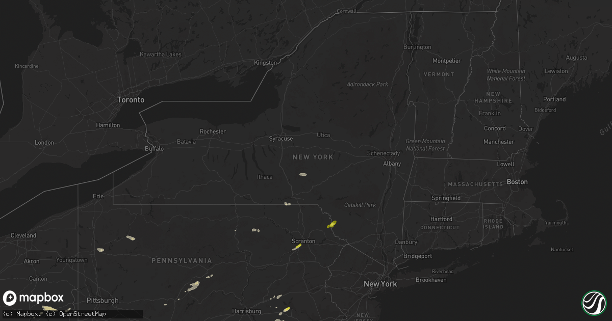
Hail Map in New York on July 1, 2022
Get this storm
July 1 map
$229
one time, instant access
Download today. No call, no setup
Keep the $229
Bought the map and want the full workflow? Apply the entire $229 to a subscription within 7 days. None of it is wasted.
Every map, not just this one
This buys you this map. Subscription and you get every map we run, in the markets you choose from a few cities to whole states to nationwide. Plus real-time alerts the moment a storm fires.
Contact data
Name, contact info, occupancy, even credit band for addresses in the footprint. You go from where it hit to who to call.
Become the source they trust
Unlimited branding weather history reports on demand. You already have the documented answer ready for the property owner, and you are the one who showed up with it.
Property data and RoofTrace estimates
Pull up any address you have got, its value and the exact code rules for that jurisdiction, straight from One Click Code. Then RoofTrace estimates the squares, pitch, and roof value, priced the way you price.
Storm reports in New York
New York
| Date | Description |
|---|---|
| 07/01/20226:55 PM CDT | Multiple reports of trees and wires down in preston. |
| 07/01/20225:53 PM CDT | Trees down in bethel. |
| 07/01/20225:50 PM CDT | Trees down in the town of delaware. |
| 07/01/20225:14 AM CDT | At 1014 PM EDT, severe thunderstorms were located along a line extending from near Greater Binghamton Airport to near Tioga Center, moving east at 25 mph. HAZARD...60 mph wind gusts and quarter size hail. SOURCE...Radar indicated. IMPACT...Hail damage to vehicles is expected. Expect wind damage to roofs, siding, and trees. Locations impacted include... Binghamton, Johnson City, Endicott, Maine, Owego, Port Dickinson, Newark Valley, Greater Binghamton Airport, Chenango Forks and West Corners. |
| 07/01/20224:16 AM CDT | At 916 PM EDT, a severe thunderstorm was located near Hagaman, or near Amsterdam, moving east at 40 mph. HAZARD...60 mph wind gusts and quarter size hail. SOURCE...Radar indicated. IMPACT...Hail damage to vehicles is expected. Expect wind damage to roofs, siding, and trees. Locations impacted include... Amsterdam, Glenville, Ballston Spa, Broadalbin, Hagaman, Mayfield, Fort Johnson, Galway, North Ballston Spa, Rock City Falls, Mount Pleasant, Charlton, Perth, Parkis Mills, West Perth, Munsonville, Shaw Corners, Barkersville, West Milton and Glenwild. |
| 07/01/20223:45 AM CDT | At 845 PM EDT, severe thunderstorms were located along a line extending from near Cherry Valley to near Cooperstown Junction, moving east at 40 mph. HAZARD...60 mph wind gusts and quarter size hail. SOURCE...Radar indicated. IMPACT...Hail damage to vehicles is expected. Expect wind damage to roofs, siding, and trees. Locations impacted include... Worcester, Middlefield, Maryland, Cooperstown, Westville, Westford, Cherry Valley, Milford, Bowerstown and Elk Creek. |
| 07/01/20223:10 AM CDT | At 810 PM EDT, a severe thunderstorm was located over Whitney Point, or 8 miles southeast of Marathon, moving east at 25 mph. HAZARD...60 mph wind gusts and quarter size hail. SOURCE...Radar indicated. IMPACT...Hail damage to vehicles is expected. Expect wind damage to roofs, siding, and trees. Locations impacted include... Coventry, Greene, Oxford, Whitney Point, Lisle, Brisben, Smithville Flats, Nineveh, South Oxford and Smithville Center. |
| 07/01/20223:08 AM CDT | At 808 PM EDT, a severe thunderstorm was located over Norwich, moving east at 30 mph. HAZARD...60 mph wind gusts and quarter size hail. SOURCE...Radar indicated. IMPACT...Hail damage to vehicles is expected. Expect wind damage to roofs, siding, and trees. Locations impacted include... Oneonta, Norwich, Edmeston, North Norwich, Oxford, Pittsfield, New Lisbon, Preston, New Berlin and Otego. |
| 07/01/20223:04 AM CDT | At 804 PM EDT, a severe thunderstorm was located near Edmeston, or 13 miles west of Cooperstown, moving east at 30 mph. HAZARD...60 mph wind gusts and quarter size hail. SOURCE...Radar indicated. IMPACT...Hail damage to vehicles is expected. Expect wind damage to roofs, siding, and trees. Locations impacted include... Worcester, Middlefield, Hartwick, Maryland, Cooperstown, Edmeston, Westville, Pittsfield, Springfield and Richfield Springs. |
| 07/01/202212:42 AM CDT | At 542 PM EDT, a severe thunderstorm was located over Coney Island, moving northeast at 30 mph. HAZARD...60 mph wind gusts and penny size hail. SOURCE...Radar indicated. IMPACT...Expect damage to trees and power lines. This severe thunderstorm will be near... Sheepshead Bay around 545 PM EDT. Flatbush around 550 PM EDT. Canarsie around 555 PM EDT. Rockaway Beach and Howard Beach around 600 PM EDT. Kennedy Airport around 605 PM EDT. Jamaica and Long Beach around 610 PM EDT. Valley Stream and Lynbrook around 615 PM EDT. Garden City and Baldwin around 620 PM EDT. Freeport and Mineola around 625 PM EDT. Levittown and Massapequa around 630 PM EDT. |
| 06/30/20229:29 PM CDT | Large tree down blocking farm to market road. |
| 06/30/20229:15 PM CDT | Multiple reports of trees down in the town of maine. |
| 06/30/20228:52 PM CDT | Tree downed across county road 68 |
| 06/30/20228:51 PM CDT | Tree and power lines downed on louden road at edie road |
| 06/30/20228:51 PM CDT | Tree downed at the corner of magnolia drive and azalea drive |
| 06/30/20228:50 PM CDT | Tree downed across the roadway at the intersection of rose terrace and louden road |
| 06/30/20228:50 PM CDT | Tree and power lines downed across ingersoll road at lilac lane |
| 06/30/20228:49 PM CDT | Tree and power lines downed at 314 louden road |
| 06/30/20228:49 PM CDT | Tree amd power lines downed on louden road between morris road and ingersoll road |
| 06/30/20228:45 PM CDT | Tree downed across smith bridge road |
| 06/30/20228:42 PM CDT | Tree downed on a trailer at brookview mobile home park |
| 06/30/20228:39 PM CDT | Tree downed on a house on lawrence street |
| 06/30/20228:28 PM CDT | Multiple trees and large branches down in the vicinity of west hill road in vestal center. |
| 06/30/20228:16 PM CDT | Tree down near church street and northern boulevard in hagaman. |
| 06/30/20228:14 PM CDT | Tree downed at the corner of regina lane and bylina lane |
| 06/30/20228:12 PM CDT | Multiple trees and powerlines down throughout amsterdam |
| 06/30/20228:12 PM CDT | Trees and powerlines downed on mesacosa road |
| 06/30/20228:10 PM CDT | Trees and wires down. |
| 06/30/20228:10 PM CDT | Trees and wires down in unadilla. |
| 06/30/20228:10 PM CDT | Multiple reports of trees and wires down in bainbridge. |
| 06/30/20228:08 PM CDT | Multiple large tree limbs down in fort johnson. Time estimated from radar. |
| 06/30/20228:08 PM CDT | Erie canal bike trail impassable between amsterdam and fort hunter due to many downed trees |
| 06/30/20228:00 PM CDT | Tree down along mohawk drive near fonda. |
| 06/30/20227:52 PM CDT | Multiple reports of trees and wires down in guilford. |
| 06/30/20227:33 PM CDT | Multiple reports of trees and wires down in gilbertsville. |
| 06/30/20227:29 PM CDT | Trees and wires down in morris. |
| 06/30/20227:25 PM CDT | Multiple reports of trees and wires down in oxford. |
| 06/30/20227:15 PM CDT | Trees and wires down on route 206 between whitney point and triangle. |
| 06/30/20227:15 PM CDT | Tree and power lines down on ticknor brook road. |
| 06/30/20227:12 PM CDT | Tree down on a house on hyde street. |
| 06/30/20227:10 PM CDT | Corrects previous tstm wnd dmg report from richfield springs. Trees and wires down. |
All States Impacted by Hail Map on July 1, 2022
Cities Impacted by Hail Map on July 1, 2022
- Moosic, PA
- Kingston, PA
- Duryea, PA
- Wilkes Barre, PA
- Pittston, PA
- Luzerne, PA
- Glenrock, WY
- Douglas, WY
- Upton, WY
- Ellsworth, NE
- Aladdin, WY
- Hulett, WY
- Reading, PA
- Reinholds, PA
- Mohnton, PA
- Tippecanoe, OH
- Freeport, OH
- Hanston, KS
- Larned, KS
- Ashburn, VA
- Spring Mills, PA
- Centre Hall, PA
- Athens, OH
- Smithfield, OH
- Mingo Junction, OH
- Dillonvale, OH
- Rayland, OH
- Steubenville, OH
- Scottown, OH
- Proctorville, OH
- Chesapeake, OH
- Encino, TX
- Crook, CO
- Hebbronville, TX
- Realitos, TX
- Concepcion, TX
- Wilson, KS
- Ellsworth, KS
- Kinzers, PA
- Gordonville, PA
- Coatesville, PA
- Leola, PA
- Ephrata, PA
- Lititz, PA
- Honey Brook, PA
- Bird In Hand, PA
- Ronks, PA
- Lancaster, PA
- Gap, PA
- Narvon, PA
- New Holland, PA
- Brownstown, PA
- Logan, OH
- Bremen, OH
- New Straitsville, OH
- Salina, KS
- Stoneboro, PA
- Washington Boro, PA
- Tionesta, PA
- Okeana, OH
- Hamilton, OH
- Oxford, OH
- Tyrone, PA
- Forksville, PA
- New Albany, PA
- Lance Creek, WY
- Myerstown, PA
- Bethel, PA
- Fredericksburg, PA
- Wheatland, WY
- Guernsey, WY
- Montezuma, KS
- Kadoka, SD
- Interior, SD
- Portage, PA
- Newmanstown, PA
- Kirksville, MO
- Sylvan Grove, KS
- Weston, CO
- Marsland, NE
- Hemingford, NE
- Kingsville, TX
- Dayton, OH
- Chillicothe, OH
- Port Charlotte, FL
- Uhrichsville, OH
- Cadiz, OH
- Scio, OH
- Gore, VA
- Onaga, KS
- Riley, KS
- Saint George, KS
- Manhattan, KS
- Milford, KS
- Olsburg, KS
- Westmoreland, KS
- Ulysses, KS
- Sublette, KS
- Satanta, KS
- Clearville, PA
- Brackney, PA
- Vestal, NY
- New Underwood, SD
- Caputa, SD
- Gillette, WY
- Kaycee, WY
- Liberty, PA
- Canton, PA
- Shunk, PA
- Narrowsburg, NY
- Beach Lake, PA
- Cochecton, NY
- Damascus, PA
- Milanville, PA
- Lake Huntington, NY
- Sturgis, SD
- Sundance, WY
- Bernville, PA
- Strausstown, PA
- Newcastle, WY
- Freeland, MD
- Reisterstown, MD
- Hampstead, MD
- Sparks Glencoe, MD
- Manchester, MD
- Parkton, MD
- Upperco, MD
- Alzada, MT
- Willow Street, PA
- New Providence, PA
- Strasburg, PA
- Haxtun, CO
- Las Vegas, NM
- Rociada, NM
- Flagstaff, AZ
- McDonough, NY
- Oxford, NY
- White Sulphur Springs, WV
- Sterling, VA
- Miles City, MT
- Volborg, MT
- Kinsey, MT
- Ismay, MT
- Willow Wood, OH
- Glendo, WY
- Hartville, WY
- Orange Grove, TX
- Alice, TX
- New Lexington, OH
- Corning, OH
- Shawnee, OH
- Hollidaysburg, PA
- Kirkwood, PA
- Quarryville, PA
- Loogootee, IN
- Whitetail, MT
- Redstone, MT
- Reserve, MT
- Flaxville, MT
- Plentywood, MT
- Ellicott City, MD
- Marriottsville, MD
- Sykesville, MD
- West Friendship, MD
- Duchesne, UT
- Shoals, IN
- Mitchell, IN
- Laurel, MT
- Alexandria, PA
- Petersburg, PA
- Pennsylvania Furnace, PA
- Warriors Mark, PA
- Spruce Creek, PA
- Van Buren, ME
- Grand Isle, ME
- St John, KS
- Pawnee Rock, KS
- Delta, PA
- Street, MD
- Conowingo, MD
- Peach Bottom, PA
- Drumore, PA
- Whiteford, MD
- Darlington, MD
- Needmore, PA
- Breezewood, PA
- Crystal Spring, PA
- Warfordsburg, PA
- Rushville, IN
- Aguilar, CO
- Assaria, KS
- Grove City, PA
- Kennerdell, PA
- Polk, PA
- Jackson Center, PA
- Maysville, KY
- Denver, PA
- Stevens, PA
- Lebanon, PA
- Cooksville, MD
- Glenwood, MD
- Woodbine, MD
- Molt, MT
- Friendsville, PA
- Binghamton, NY
- Claremont, IL
- Oblong, IL
- Willow Hill, IL
- Sumner, IL
- West Liberty, IL
- Cottonwood Falls, KS
- Matfield Green, KS
- Marion, KS
- Lincolnville, KS
- Elmdale, KS
- Strong City, KS
- Cedar Point, KS
- Walsenburg, CO
- Tucson, AZ
- Branson, CO
- Robinson, IL
- Stoy, IL
- Newnan, GA
- Glenford, OH
- Thornville, OH
- Gerrardstown, WV
- Hedgesville, WV
- Halstead, KS
- Moundridge, KS
- Owanka, SD
- Hesston, KS
- Inman, KS
- Newton, KS
- Mcpherson, KS
- Burrton, KS
- Buhler, KS
- Tribune, KS
- Leoti, KS
- Trinidad, CO
- Trinchera, CO
- Malta, OH
- Kanopolis, KS
- Brookville, KS
- Franklin, GA
- Lagrange, GA
- Meadow Bridge, WV
- Heath, OH
- Hopewell, OH
- Mount Perry, OH
- Miamisburg, OH
- Berkeley Springs, WV
- Winchester, VA
- Glengary, WV
- Cross Junction, VA
- Olney, IL
- Newton, IL
- Sainte Marie, IL
- Dundas, IL
- Dayton, VA
- Bridgewater, VA
- Pomeroy, OH
- Long Bottom, OH
- Saint Mary, MO
- Perryville, MO
- Somerset, OH
- Whitney Point, NY
- Lisle, NY
- Catlettsburg, KY
- Ellsworth Afb, SD
- Rapid City, SD
- Box Elder, SD
- Lorraine, KS
- Mount Lemmon, AZ
- Falfurrias, TX
- Glenwood, IN
- Fort Riley, KS
- Louisa, KY
- Prichard, WV
- Beatrice, AL
- Hutchinson, KS
- Valley Center, KS
- Sedgwick, KS
- Belle Fourche, SD
- Frenchville, ME
- High View, WV
- Yellow Spring, WV
- Keyes, OK
- Crooksville, OH
- Riviera, TX
- Premont, TX
- Wall, SD
- Wasta, SD
- Great Bend, KS
- Kimbolton, OH
- Vernal, UT
- Baltimore, OH
- San Diego, TX
- Gallipolis Ferry, WV
- Kingston, TN
- Ravenswood, WV
- Solomon, KS
- New Cambria, KS
- New Lebanon, OH
- Germantown, OH
- Minford, OH
- Lucasville, OH
- Buchtel, OH
- Union Furnace, OH
- Haydenville, OH
- Nelsonville, OH
- Walton, KS
- Zanesville, OH
- Fremont, OH
- Helena, OH
- Wanblee, SD
- Long Valley, SD
- Porcupine, SD
- Martin, SD
- Allen, SD
- Batesland, SD
- Billings, MT
- Piedmont, SD
- Old Forge, PA
- Callicoon, NY
- Honesdale, PA
- Kenoza Lake, NY


