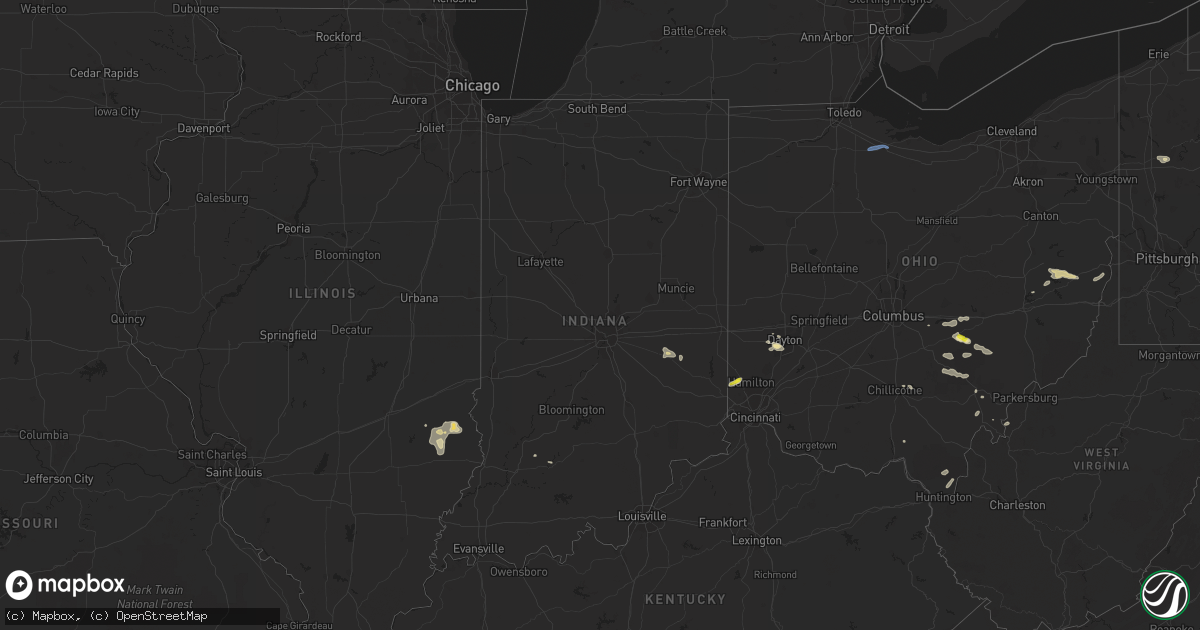
Hail Map in Indiana on July 1, 2022
Get this storm
July 1 map
$229
one time, instant access
Download today. No call, no setup
Keep the $229
Bought the map and want the full workflow? Apply the entire $229 to a subscription within 7 days. None of it is wasted.
Every map, not just this one
This buys you this map. Subscription and you get every map we run, in the markets you choose from a few cities to whole states to nationwide. Plus real-time alerts the moment a storm fires.
Contact data
Name, contact info, occupancy, even credit band for addresses in the footprint. You go from where it hit to who to call.
Become the source they trust
Unlimited branding weather history reports on demand. You already have the documented answer ready for the property owner, and you are the one who showed up with it.
Property data and RoofTrace estimates
Pull up any address you have got, its value and the exact code rules for that jurisdiction, straight from One Click Code. Then RoofTrace estimates the squares, pitch, and roof value, priced the way you price.
Storm reports in Indiana
Indiana
| Date | Description |
|---|---|
| 07/01/20226:50 PM CDT | Multiple trees snapped or uprooted at rush county fairgrounds. Also flying debris as tents were blown down and tables blown over. Additionally a communication tower was |
| 07/01/20222:44 PM CDT | A local report indicates 58 MPH wind near 2 NNE LANDESS |
| 07/01/20223:25 AM CDT | At 824 PM CDT, severe thunderstorms were located along a line extending from near Palestine to Robinson to Willow Hill, moving east-southeast at 15 mph. HAZARD...60 mph wind gusts and quarter size hail. SOURCE...Radar indicated. IMPACT...Hail damage to vehicles is expected. Expect wind damage to roofs, siding, and trees. Severe thunderstorms will be near... Hutsonville around 830 PM CDT. Robinson around 835 PM CDT.Other locations in the path of these severe thunderstorms includeFlat Rock, Palestine, Hardinville and New Hebron. |
All States Impacted by Hail Map on July 1, 2022
Cities Impacted by Hail Map on July 1, 2022
- Moosic, PA
- Kingston, PA
- Duryea, PA
- Wilkes Barre, PA
- Pittston, PA
- Luzerne, PA
- Glenrock, WY
- Douglas, WY
- Upton, WY
- Ellsworth, NE
- Aladdin, WY
- Hulett, WY
- Reading, PA
- Reinholds, PA
- Mohnton, PA
- Tippecanoe, OH
- Freeport, OH
- Hanston, KS
- Larned, KS
- Ashburn, VA
- Spring Mills, PA
- Centre Hall, PA
- Athens, OH
- Smithfield, OH
- Mingo Junction, OH
- Dillonvale, OH
- Rayland, OH
- Steubenville, OH
- Scottown, OH
- Proctorville, OH
- Chesapeake, OH
- Encino, TX
- Crook, CO
- Hebbronville, TX
- Realitos, TX
- Concepcion, TX
- Wilson, KS
- Ellsworth, KS
- Kinzers, PA
- Gordonville, PA
- Coatesville, PA
- Leola, PA
- Ephrata, PA
- Lititz, PA
- Honey Brook, PA
- Bird In Hand, PA
- Ronks, PA
- Lancaster, PA
- Gap, PA
- Narvon, PA
- New Holland, PA
- Brownstown, PA
- Logan, OH
- Bremen, OH
- New Straitsville, OH
- Salina, KS
- Stoneboro, PA
- Washington Boro, PA
- Tionesta, PA
- Okeana, OH
- Hamilton, OH
- Oxford, OH
- Tyrone, PA
- Forksville, PA
- New Albany, PA
- Lance Creek, WY
- Myerstown, PA
- Bethel, PA
- Fredericksburg, PA
- Wheatland, WY
- Guernsey, WY
- Montezuma, KS
- Kadoka, SD
- Interior, SD
- Portage, PA
- Newmanstown, PA
- Kirksville, MO
- Sylvan Grove, KS
- Weston, CO
- Marsland, NE
- Hemingford, NE
- Kingsville, TX
- Dayton, OH
- Chillicothe, OH
- Port Charlotte, FL
- Uhrichsville, OH
- Cadiz, OH
- Scio, OH
- Gore, VA
- Onaga, KS
- Riley, KS
- Saint George, KS
- Manhattan, KS
- Milford, KS
- Olsburg, KS
- Westmoreland, KS
- Ulysses, KS
- Sublette, KS
- Satanta, KS
- Clearville, PA
- Brackney, PA
- Vestal, NY
- New Underwood, SD
- Caputa, SD
- Gillette, WY
- Kaycee, WY
- Liberty, PA
- Canton, PA
- Shunk, PA
- Narrowsburg, NY
- Beach Lake, PA
- Cochecton, NY
- Damascus, PA
- Milanville, PA
- Lake Huntington, NY
- Sturgis, SD
- Sundance, WY
- Bernville, PA
- Strausstown, PA
- Newcastle, WY
- Freeland, MD
- Reisterstown, MD
- Hampstead, MD
- Sparks Glencoe, MD
- Manchester, MD
- Parkton, MD
- Upperco, MD
- Alzada, MT
- Willow Street, PA
- New Providence, PA
- Strasburg, PA
- Haxtun, CO
- Las Vegas, NM
- Rociada, NM
- Flagstaff, AZ
- McDonough, NY
- Oxford, NY
- White Sulphur Springs, WV
- Sterling, VA
- Miles City, MT
- Volborg, MT
- Kinsey, MT
- Ismay, MT
- Willow Wood, OH
- Glendo, WY
- Hartville, WY
- Orange Grove, TX
- Alice, TX
- New Lexington, OH
- Corning, OH
- Shawnee, OH
- Hollidaysburg, PA
- Kirkwood, PA
- Quarryville, PA
- Loogootee, IN
- Whitetail, MT
- Redstone, MT
- Reserve, MT
- Flaxville, MT
- Plentywood, MT
- Ellicott City, MD
- Marriottsville, MD
- Sykesville, MD
- West Friendship, MD
- Duchesne, UT
- Shoals, IN
- Mitchell, IN
- Laurel, MT
- Alexandria, PA
- Petersburg, PA
- Pennsylvania Furnace, PA
- Warriors Mark, PA
- Spruce Creek, PA
- Van Buren, ME
- Grand Isle, ME
- St John, KS
- Pawnee Rock, KS
- Delta, PA
- Street, MD
- Conowingo, MD
- Peach Bottom, PA
- Drumore, PA
- Whiteford, MD
- Darlington, MD
- Needmore, PA
- Breezewood, PA
- Crystal Spring, PA
- Warfordsburg, PA
- Rushville, IN
- Aguilar, CO
- Assaria, KS
- Grove City, PA
- Kennerdell, PA
- Polk, PA
- Jackson Center, PA
- Maysville, KY
- Denver, PA
- Stevens, PA
- Lebanon, PA
- Cooksville, MD
- Glenwood, MD
- Woodbine, MD
- Molt, MT
- Friendsville, PA
- Binghamton, NY
- Claremont, IL
- Oblong, IL
- Willow Hill, IL
- Sumner, IL
- West Liberty, IL
- Cottonwood Falls, KS
- Matfield Green, KS
- Marion, KS
- Lincolnville, KS
- Elmdale, KS
- Strong City, KS
- Cedar Point, KS
- Walsenburg, CO
- Tucson, AZ
- Branson, CO
- Robinson, IL
- Stoy, IL
- Newnan, GA
- Glenford, OH
- Thornville, OH
- Gerrardstown, WV
- Hedgesville, WV
- Halstead, KS
- Moundridge, KS
- Owanka, SD
- Hesston, KS
- Inman, KS
- Newton, KS
- Mcpherson, KS
- Burrton, KS
- Buhler, KS
- Tribune, KS
- Leoti, KS
- Trinidad, CO
- Trinchera, CO
- Malta, OH
- Kanopolis, KS
- Brookville, KS
- Franklin, GA
- Lagrange, GA
- Meadow Bridge, WV
- Heath, OH
- Hopewell, OH
- Mount Perry, OH
- Miamisburg, OH
- Berkeley Springs, WV
- Winchester, VA
- Glengary, WV
- Cross Junction, VA
- Olney, IL
- Newton, IL
- Sainte Marie, IL
- Dundas, IL
- Dayton, VA
- Bridgewater, VA
- Pomeroy, OH
- Long Bottom, OH
- Saint Mary, MO
- Perryville, MO
- Somerset, OH
- Whitney Point, NY
- Lisle, NY
- Catlettsburg, KY
- Ellsworth Afb, SD
- Rapid City, SD
- Box Elder, SD
- Lorraine, KS
- Mount Lemmon, AZ
- Falfurrias, TX
- Glenwood, IN
- Fort Riley, KS
- Louisa, KY
- Prichard, WV
- Beatrice, AL
- Hutchinson, KS
- Valley Center, KS
- Sedgwick, KS
- Belle Fourche, SD
- Frenchville, ME
- High View, WV
- Yellow Spring, WV
- Keyes, OK
- Crooksville, OH
- Riviera, TX
- Premont, TX
- Wall, SD
- Wasta, SD
- Great Bend, KS
- Kimbolton, OH
- Vernal, UT
- Baltimore, OH
- San Diego, TX
- Gallipolis Ferry, WV
- Kingston, TN
- Ravenswood, WV
- Solomon, KS
- New Cambria, KS
- New Lebanon, OH
- Germantown, OH
- Minford, OH
- Lucasville, OH
- Buchtel, OH
- Union Furnace, OH
- Haydenville, OH
- Nelsonville, OH
- Walton, KS
- Zanesville, OH
- Fremont, OH
- Helena, OH
- Wanblee, SD
- Long Valley, SD
- Porcupine, SD
- Martin, SD
- Allen, SD
- Batesland, SD
- Billings, MT
- Piedmont, SD
- Old Forge, PA
- Callicoon, NY
- Honesdale, PA
- Kenoza Lake, NY


