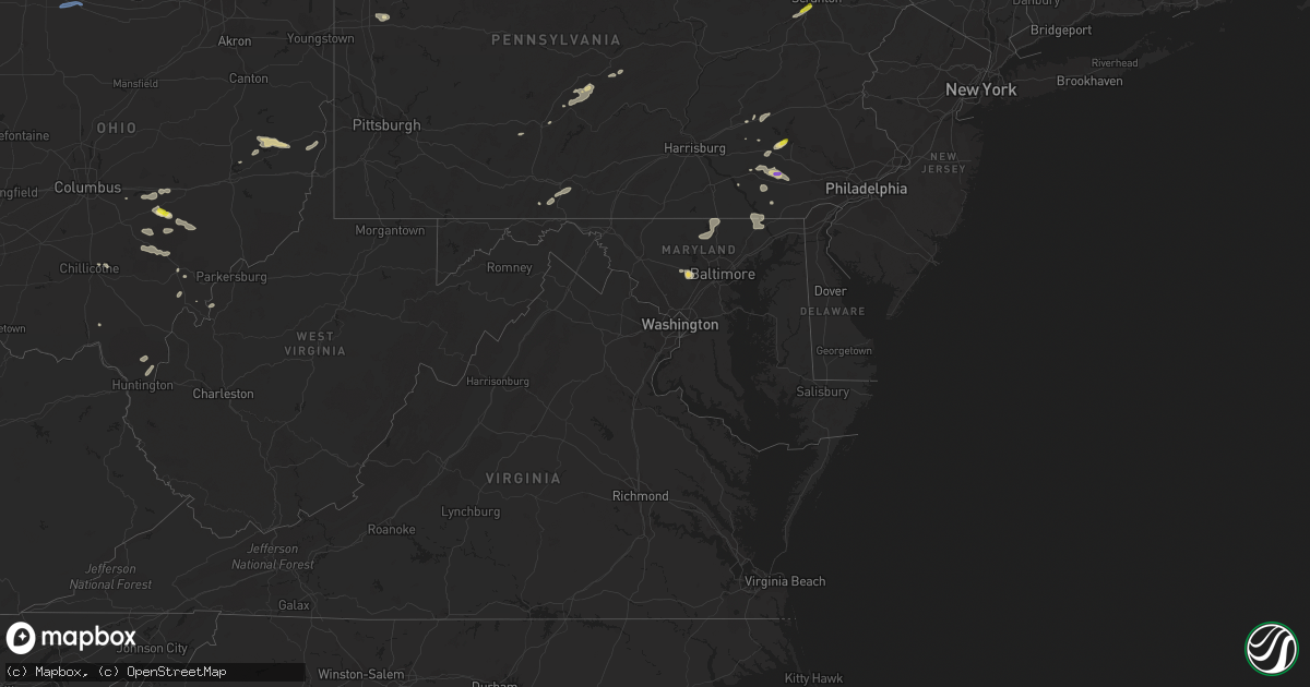
Hail Map in Maryland on July 1, 2022
Get this storm
July 1 map
$229
one time, instant access
Download today. No call, no setup
Keep the $229
Bought the map and want the full workflow? Apply the entire $229 to a subscription within 7 days. None of it is wasted.
Every map, not just this one
This buys you this map. Subscription and you get every map we run, in the markets you choose from a few cities to whole states to nationwide. Plus real-time alerts the moment a storm fires.
Contact data
Name, contact info, occupancy, even credit band for addresses in the footprint. You go from where it hit to who to call.
Become the source they trust
Unlimited branding weather history reports on demand. You already have the documented answer ready for the property owner, and you are the one who showed up with it.
Property data and RoofTrace estimates
Pull up any address you have got, its value and the exact code rules for that jurisdiction, straight from One Click Code. Then RoofTrace estimates the squares, pitch, and roof value, priced the way you price.
Storm reports in Maryland
Maryland
| Date | Description |
|---|---|
| 07/01/20222:48 PM CDT | A tree blew down near the 710 block of priestford rd. |
| 07/01/20222:45 PM CDT | Tree damage was reported around darlington. Trees blew down near the intersection of md-623 castleton road and us-1 conowingo road. Trees and wires blew down near the i |
| 07/01/20222:44 PM CDT | A tree blew down near castleton rd and conowingo rd. |
| 07/01/20222:08 PM CDT | Trees blew down off of folly quarter road near carroll mill road. |
| 07/01/20222:06 PM CDT | Tree down off of folly quarter road near carroll mill road. |
| 07/01/20222:02 PM CDT | Tree down blocking 20000 blk of west liberty rd |
| 07/01/20222:02 PM CDT | Tree down blocking 20000 blk of west liberty rd |
| 07/01/20222:02 PM CDT | Tree damage was reported near bentley springs... Including in the 20000 block of west liberty road. |
| 07/01/20221:50 PM CDT | Tree down on butler rd |
| 07/01/20221:28 PM CDT | 2 trees down. |
| 07/01/20221:28 PM CDT | Two trees blew down near the intersection of north gorsuch road and leisters church road. |
| 07/01/20221:24 PM CDT | Tree branch on wires |
| 07/01/20221:18 PM CDT | Tree damage was reported near westminster. Trees blew down onto wires on wyndwood terrace. A large tree limb blew down onto wires near the intersection of rinehart road |
| 07/01/20221:18 PM CDT | Trees blew down onto wires on wyndwood terrace. |
| 07/01/20221:18 PM CDT | Tree on wires |
| 07/01/20221:11 PM CDT | Trees blew down onto wires near the intersection of pipe creek road and stem road. |
| 07/01/20221:11 PM CDT | Tree down on wires. |
| 07/01/202212:53 PM CDT | A large tree limb fell and brought down power lines near the 30 block of east 2nd street. |
| 07/01/202212:52 PM CDT | A large tree limb fell and brought down power lines near old annapolis rd and bridle path ln. |
| 07/01/202212:50 PM CDT | Tree down near route 15 & mountville road |
| 07/01/202212:43 PM CDT | Tree damage was reported near and north of frederick. Several trees blew down on ford road. A tree blew down near the intersection of us-15 and mountville road. A large |
| 07/01/202212:43 PM CDT | Trees down on ford road. |
| 07/01/202212:43 PM CDT | Several trees blew down on ford road. |
| 07/01/20227:58 AM CDT | At 1257 PM EDT, a severe thunderstorm was located near Kearneysville, or near Shepherdstown, moving east at 30 mph. HAZARD...60 mph wind gusts and quarter size hail. SOURCE...Radar indicated. IMPACT...Damaging winds will cause some trees and large branches to fall. This could injure those outdoors, as well as damage homes and vehicles. Roadways may become blocked by downed trees. Localized power outages are possible. Unsecured light objects may become projectiles. Locations impacted include... Shepherdstown, Brunswick, Ranson, Boonsboro, Braddock Heights, Mount Lena, Harpers Ferry, Kearneysville, Jefferson, Myersville, Keedysville, Sharpsburg, Shenandoah Junction, Fairplay, Rosemont, Rohrersville, Burkittsville, Gapland, Brownsville and Antietam. |
| 06/30/202210:44 PM CDT | At 344 PM EDT, a severe thunderstorm was located over Rock Springs, or 13 miles north of Havre De Grace, moving east at 30 mph. HAZARD...60 mph wind gusts and quarter size hail. SOURCE...Radar indicated. IMPACT...Minor damage to vehicles is possible. Wind damage to roofs, siding, trees, and power lines is possible. Locations impacted include... Newark, Oxford, West Grove, Homeville, Glen Roy, North Star, Landenberg, Mount Vernon, Kemblesville, Pike Creek, Hockessin, Avondale, Toughkenamon and Brookside.This includes Interstate 95 in Delaware near mile marker 5. |
| 06/30/202210:42 PM CDT | At 341 PM EDT, a severe thunderstorm was located over Conowingo, or 9 miles northwest of Havre De Grace, moving east at 40 mph. HAZARD...60 mph wind gusts and quarter size hail. SOURCE...Radar indicated. IMPACT...Damaging winds will cause some trees and large branches to fall. This could injure those outdoors, as well as damage homes and vehicles. Roadways may become blocked by downed trees. Localized power outages are possible. Unsecured light objects may become projectiles. Locations impacted include... Calvert, North East, Rising Sun, Zion, Richardsmere, Woodlawn, West Nottingham, Octoraro, Conowingo, Rock Springs, Bay View, Farmington, Port Deposit, Darlington, Scarboro and Whiteford. |
| 06/30/20229:57 PM CDT | At 257 PM EDT, a severe thunderstorm was located over Sykesville, or 10 miles northwest of Historic Ellicott City, moving east at 30 mph. HAZARD...60 mph wind gusts and quarter size hail. SOURCE...Radar indicated. IMPACT...Damaging winds will cause some trees and large branches to fall. This could injure those outdoors, as well as damage homes and vehicles. Roadways may become blocked by downed trees. Localized power outages are possible. Unsecured light objects may become projectiles. Locations impacted include... Pikesville, Historic Ellicott City, Ellicott City, Catonsville, Woodlawn, Randallstown, Owings Mills, Eldersburg, Milford Mill, Reisterstown, Lochearn, Sykesville, Oakland, Garrison, Henryton, West Friendship, Woodstock, Gaither, Granite and Mcdonogh. |
| 06/30/20229:57 PM CDT | At 257 PM EDT, a severe thunderstorm was located over Stewartstown, moving east at 35 mph. HAZARD...60 mph wind gusts and quarter size hail. SOURCE...Radar indicated. IMPACT...Hail damage to vehicles is expected. Expect wind damage to roofs, siding, and trees. This severe thunderstorm will be near... Stewartstown and Cross Roads around 300 PM EDT. Delta, Sunnyburn and Holtwood around 320 PM EDT. Wakefield and Quarryville around 340 PM EDT.Other locations impacted by this severe thunderstorm include FawnGrove, Buck, Peach Bottom, Little Britain and Airville.This includes Interstate 83 from mile markers 0 to 4. |
| 06/30/20229:33 PM CDT | At 233 PM EDT, a severe thunderstorm was located over Hampstead, or near Westminster, moving northeast at 35 mph. HAZARD...60 mph wind gusts and quarter size hail. SOURCE...Radar indicated. IMPACT...Damaging winds will cause some trees and large branches to fall. This could injure those outdoors, as well as damage homes and vehicles. Roadways may become blocked by downed trees. Localized power outages are possible. Unsecured light objects may become projectiles. Locations impacted include... Westminster, Hampstead, Manchester, Carrollton, Upperco, Freeland, Lineboro, Boring, Bentley Springs, Patapsco, Reese, Parkton, Hereford, Millers, Greenmount, Butler and Maryland Line. |
| 06/30/20229:26 PM CDT | At 226 PM EDT, a severe thunderstorm was located over Green Valley, or near Damascus, moving east at 40 mph. HAZARD...60 mph wind gusts and quarter size hail. SOURCE...Radar indicated. IMPACT...Damaging winds will cause some trees and large branches to fall. This could injure those outdoors, as well as damage homes and vehicles. Roadways may become blocked by downed trees. Localized power outages are possible. Unsecured light objects may become projectiles. Locations impacted include... Damascus, Ballenger Creek, Mount Airy, New Market, Green Valley, Linganore-Bartonsville, Clarksburg, Monrovia, Ijamsville, Lisbon, Watersville, Poplar Springs, Roxbury Mills and Woodbine. |
| 06/30/20229:11 PM CDT | At 211 PM EDT, a severe thunderstorm was located near Taneytown, or near Westminster, moving east at 25 mph. HAZARD...60 mph wind gusts and quarter size hail. SOURCE...Radar indicated. IMPACT...Damaging winds will cause some trees and large branches to fall. This could injure those outdoors, as well as damage homes and vehicles. Roadways may become blocked by downed trees. Localized power outages are possible. Unsecured light objects may become projectiles. Locations impacted include... Westminster, Taneytown, New Windsor, Union Bridge, Carrollton, Linwood, Patapsco, Reese, Uniontown, Wagners Mill, Marston, Keymar and Unionville. |
| 06/30/20228:33 PM CDT | At 133 PM EDT, a severe thunderstorm was located near Boonsboro, or 9 miles west of Frederick, moving east at 25 mph. HAZARD...60 mph wind gusts and quarter size hail. SOURCE...Radar indicated. IMPACT...Damaging winds will cause some trees and large branches to fall. This could injure those outdoors, as well as damage homes and vehicles. Roadways may become blocked by downed trees. Localized power outages are possible. Unsecured light objects may become projectiles. Locations impacted include... Frederick, Harry Grove Stadium, Ballenger Creek, Walkersville, Braddock Heights, New Market, Discovery-Spring Garden, Clover Hill, Linganore-Bartonsville, Jefferson, Woodsboro, Buckeystown, Libertytown, Monrovia, Ijamsville, Bloomfield, Mount Pleasant, Clifton, Utica and Middletown In Frederick Md. |
All States Impacted by Hail Map on July 1, 2022
Cities Impacted by Hail Map on July 1, 2022
- Moosic, PA
- Kingston, PA
- Duryea, PA
- Wilkes Barre, PA
- Pittston, PA
- Luzerne, PA
- Glenrock, WY
- Douglas, WY
- Upton, WY
- Ellsworth, NE
- Aladdin, WY
- Hulett, WY
- Reading, PA
- Reinholds, PA
- Mohnton, PA
- Tippecanoe, OH
- Freeport, OH
- Hanston, KS
- Larned, KS
- Ashburn, VA
- Spring Mills, PA
- Centre Hall, PA
- Athens, OH
- Smithfield, OH
- Mingo Junction, OH
- Dillonvale, OH
- Rayland, OH
- Steubenville, OH
- Scottown, OH
- Proctorville, OH
- Chesapeake, OH
- Encino, TX
- Crook, CO
- Hebbronville, TX
- Realitos, TX
- Concepcion, TX
- Wilson, KS
- Ellsworth, KS
- Kinzers, PA
- Gordonville, PA
- Coatesville, PA
- Leola, PA
- Ephrata, PA
- Lititz, PA
- Honey Brook, PA
- Bird In Hand, PA
- Ronks, PA
- Lancaster, PA
- Gap, PA
- Narvon, PA
- New Holland, PA
- Brownstown, PA
- Logan, OH
- Bremen, OH
- New Straitsville, OH
- Salina, KS
- Stoneboro, PA
- Washington Boro, PA
- Tionesta, PA
- Okeana, OH
- Hamilton, OH
- Oxford, OH
- Tyrone, PA
- Forksville, PA
- New Albany, PA
- Lance Creek, WY
- Myerstown, PA
- Bethel, PA
- Fredericksburg, PA
- Wheatland, WY
- Guernsey, WY
- Montezuma, KS
- Kadoka, SD
- Interior, SD
- Portage, PA
- Newmanstown, PA
- Kirksville, MO
- Sylvan Grove, KS
- Weston, CO
- Marsland, NE
- Hemingford, NE
- Kingsville, TX
- Dayton, OH
- Chillicothe, OH
- Port Charlotte, FL
- Uhrichsville, OH
- Cadiz, OH
- Scio, OH
- Gore, VA
- Onaga, KS
- Riley, KS
- Saint George, KS
- Manhattan, KS
- Milford, KS
- Olsburg, KS
- Westmoreland, KS
- Ulysses, KS
- Sublette, KS
- Satanta, KS
- Clearville, PA
- Brackney, PA
- Vestal, NY
- New Underwood, SD
- Caputa, SD
- Gillette, WY
- Kaycee, WY
- Liberty, PA
- Canton, PA
- Shunk, PA
- Narrowsburg, NY
- Beach Lake, PA
- Cochecton, NY
- Damascus, PA
- Milanville, PA
- Lake Huntington, NY
- Sturgis, SD
- Sundance, WY
- Bernville, PA
- Strausstown, PA
- Newcastle, WY
- Freeland, MD
- Reisterstown, MD
- Hampstead, MD
- Sparks Glencoe, MD
- Manchester, MD
- Parkton, MD
- Upperco, MD
- Alzada, MT
- Willow Street, PA
- New Providence, PA
- Strasburg, PA
- Haxtun, CO
- Las Vegas, NM
- Rociada, NM
- Flagstaff, AZ
- McDonough, NY
- Oxford, NY
- White Sulphur Springs, WV
- Sterling, VA
- Miles City, MT
- Volborg, MT
- Kinsey, MT
- Ismay, MT
- Willow Wood, OH
- Glendo, WY
- Hartville, WY
- Orange Grove, TX
- Alice, TX
- New Lexington, OH
- Corning, OH
- Shawnee, OH
- Hollidaysburg, PA
- Kirkwood, PA
- Quarryville, PA
- Loogootee, IN
- Whitetail, MT
- Redstone, MT
- Reserve, MT
- Flaxville, MT
- Plentywood, MT
- Ellicott City, MD
- Marriottsville, MD
- Sykesville, MD
- West Friendship, MD
- Duchesne, UT
- Shoals, IN
- Mitchell, IN
- Laurel, MT
- Alexandria, PA
- Petersburg, PA
- Pennsylvania Furnace, PA
- Warriors Mark, PA
- Spruce Creek, PA
- Van Buren, ME
- Grand Isle, ME
- St John, KS
- Pawnee Rock, KS
- Delta, PA
- Street, MD
- Conowingo, MD
- Peach Bottom, PA
- Drumore, PA
- Whiteford, MD
- Darlington, MD
- Needmore, PA
- Breezewood, PA
- Crystal Spring, PA
- Warfordsburg, PA
- Rushville, IN
- Aguilar, CO
- Assaria, KS
- Grove City, PA
- Kennerdell, PA
- Polk, PA
- Jackson Center, PA
- Maysville, KY
- Denver, PA
- Stevens, PA
- Lebanon, PA
- Cooksville, MD
- Glenwood, MD
- Woodbine, MD
- Molt, MT
- Friendsville, PA
- Binghamton, NY
- Claremont, IL
- Oblong, IL
- Willow Hill, IL
- Sumner, IL
- West Liberty, IL
- Cottonwood Falls, KS
- Matfield Green, KS
- Marion, KS
- Lincolnville, KS
- Elmdale, KS
- Strong City, KS
- Cedar Point, KS
- Walsenburg, CO
- Tucson, AZ
- Branson, CO
- Robinson, IL
- Stoy, IL
- Newnan, GA
- Glenford, OH
- Thornville, OH
- Gerrardstown, WV
- Hedgesville, WV
- Halstead, KS
- Moundridge, KS
- Owanka, SD
- Hesston, KS
- Inman, KS
- Newton, KS
- Mcpherson, KS
- Burrton, KS
- Buhler, KS
- Tribune, KS
- Leoti, KS
- Trinidad, CO
- Trinchera, CO
- Malta, OH
- Kanopolis, KS
- Brookville, KS
- Franklin, GA
- Lagrange, GA
- Meadow Bridge, WV
- Heath, OH
- Hopewell, OH
- Mount Perry, OH
- Miamisburg, OH
- Berkeley Springs, WV
- Winchester, VA
- Glengary, WV
- Cross Junction, VA
- Olney, IL
- Newton, IL
- Sainte Marie, IL
- Dundas, IL
- Dayton, VA
- Bridgewater, VA
- Pomeroy, OH
- Long Bottom, OH
- Saint Mary, MO
- Perryville, MO
- Somerset, OH
- Whitney Point, NY
- Lisle, NY
- Catlettsburg, KY
- Ellsworth Afb, SD
- Rapid City, SD
- Box Elder, SD
- Lorraine, KS
- Mount Lemmon, AZ
- Falfurrias, TX
- Glenwood, IN
- Fort Riley, KS
- Louisa, KY
- Prichard, WV
- Beatrice, AL
- Hutchinson, KS
- Valley Center, KS
- Sedgwick, KS
- Belle Fourche, SD
- Frenchville, ME
- High View, WV
- Yellow Spring, WV
- Keyes, OK
- Crooksville, OH
- Riviera, TX
- Premont, TX
- Wall, SD
- Wasta, SD
- Great Bend, KS
- Kimbolton, OH
- Vernal, UT
- Baltimore, OH
- San Diego, TX
- Gallipolis Ferry, WV
- Kingston, TN
- Ravenswood, WV
- Solomon, KS
- New Cambria, KS
- New Lebanon, OH
- Germantown, OH
- Minford, OH
- Lucasville, OH
- Buchtel, OH
- Union Furnace, OH
- Haydenville, OH
- Nelsonville, OH
- Walton, KS
- Zanesville, OH
- Fremont, OH
- Helena, OH
- Wanblee, SD
- Long Valley, SD
- Porcupine, SD
- Martin, SD
- Allen, SD
- Batesland, SD
- Billings, MT
- Piedmont, SD
- Old Forge, PA
- Callicoon, NY
- Honesdale, PA
- Kenoza Lake, NY


