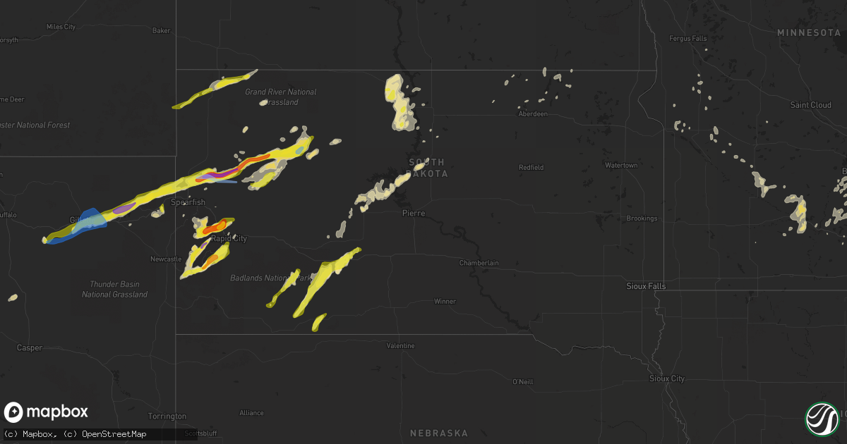
Hail Map in South Dakota on June 28, 2020
Get this storm
June 28 map
$229
one time, instant access
Download today. No call, no setup
Keep the $229
Bought the map and want the full workflow? Apply the entire $229 to a subscription within 7 days. None of it is wasted.
Every map, not just this one
This buys you this map. Subscription and you get every map we run, in the markets you choose from a few cities to whole states to nationwide. Plus real-time alerts the moment a storm fires.
Contact data
Name, contact info, occupancy, even credit band for addresses in the footprint. You go from where it hit to who to call.
Become the source they trust
Unlimited branding weather history reports on demand. You already have the documented answer ready for the property owner, and you are the one who showed up with it.
Property data and RoofTrace estimates
Pull up any address you have got, its value and the exact code rules for that jurisdiction, straight from One Click Code. Then RoofTrace estimates the squares, pitch, and roof value, priced the way you price.
Storm reports in South Dakota
South Dakota
| Date | Description |
|---|---|
| 06/28/20206:50 PM CDT | A local report indicates 2.00 inch wind near 4 N SILVER CITY |
| 06/28/20206:42 PM CDT | A local report indicates 69 MPH wind near 1 N BUFFALO |
| 06/28/20206:35 PM CDT | A local report indicates 1.00 inch wind near 3 N MYSTIC |
| 06/28/20206:20 PM CDT | A local report indicates 1.50 inch wind near 2 N NISLAND |
| 06/28/20206:20 PM CDT | A local report indicates 58 MPH wind near 1 NNW NISLAND |
| 06/28/20206:15 PM CDT | A local report indicates 70 MPH wind near 2 SE BELLE FOURCHE RESV |
| 06/28/20206:15 PM CDT | Roof torn off shed |
| 06/28/20206:10 PM CDT | A local report indicates 60 MPH wind near 1 N CAMP CROOK |
| 06/28/20206:05 PM CDT | A local report indicates 60 MPH wind near BELLE FOURCHE |
| 06/28/20205:47 PM CDT | A local report indicates 1.00 inch wind near 9 WSW BELLE FOURCHE |
| 06/28/20205:11 AM CDT | At 1011 PM CDT/911 PM MDT/, a severe thunderstorm was located near Grand River Casino, or near Mobridge, moving east at 25 mph. HAZARD...60 mph wind gusts and quarter size hail. SOURCE...Radar indicated. IMPACT...Hail damage to vehicles is expected. Expect wind damage to roofs, siding, and trees. Locations impacted include... Mobridge, Glenham, Indian Memorial Rec Area, New Everets Resort, Revheim Bay Rec Area, Grand River Casino, Indian Creek Rec Area and Blackfoot. |
| 06/28/20204:46 AM CDT | At 946 PM CDT/846 PM MDT/, a severe thunderstorm was located near Little Eagle, or 9 miles southeast of Mclaughlin, moving east at 25 mph. HAZARD...60 mph wind gusts and quarter size hail. SOURCE...Radar indicated. IMPACT...Hail damage to vehicles is expected. Expect wind damage to roofs, siding, and trees. Locations impacted include... Wakpala, Pollock, Kenel and Mahto. |
| 06/28/20204:44 AM CDT | At 943 PM MDT, a severe thunderstorm was located 5 miles west of Belvidere, or 6 miles east of Kadoka, moving northeast at 35 mph. HAZARD...60 mph wind gusts and quarter size hail. SOURCE...Radar indicated. IMPACT...Hail damage to vehicles is expected. Expect wind damage to roofs, siding, and trees. This severe thunderstorm will be near... Nowlin around 1005 PM MDT. Midland around 1015 PM MDT.This includes Interstate 90 in South Dakota between Mile Markers 158and 174. |
| 06/28/20204:26 AM CDT | At 926 PM CDT, severe thunderstorms were located along a line extending from near Solen to 6 miles east of Selfridge, moving east at 15 mph. HAZARD...60 mph wind gusts and quarter size hail. SOURCE...Radar indicated. IMPACT...Hail damage to vehicles is expected. Expect wind damage to roofs, siding, and trees. Severe thunderstorms will be near... Prairie Knights Resort around 945 PM CDT. Cannon Ball around 955 PM CDT. Fort Yates around 1005 PM CDT. |
| 06/28/20203:54 AM CDT | At 854 PM MDT, severe thunderstorms were located along a line extending from 10 miles east of Badlands National Park to 6 miles west of Wanblee, moving northeast at 30 mph. HAZARD...60 mph wind gusts and quarter size hail. SOURCE...Radar indicated. IMPACT...Hail damage to vehicles is expected. Expect wind damage to roofs, siding, and trees. Locations impacted include... Kadoka, Potato Creek, Wanblee, Interior, Belvidere, Cactus Flat, Cedar Pass, Cottonwood, Minuteman Missile Visitors Center, Intersection of Highway 73 and White River and northeastern Badlands National Park.This includes Interstate 90 in South Dakota between Mile Markers 118and 163. |
| 06/28/20203:11 AM CDT | At 811 PM MDT, a severe thunderstorm was located over Reptile Gardens, or 7 miles south of Rapid City, moving northeast at 30 mph. HAZARD...60 mph wind gusts and half dollar size hail. SOURCE...Radar indicated. IMPACT...Hail damage to vehicles is expected. Expect wind damage to roofs, siding, and trees. This severe thunderstorm will be near... Rapid City and Hart Ranch around 815 PM MDT. Black Gap around 820 PM MDT. Rapid Valley around 825 PM MDT. New Underwood around 900 PM MDT.This includes Interstate 90 in South Dakota between Mile Markers 56and 82. |
| 06/28/20203:09 AM CDT | At 808 PM MDT, severe thunderstorms were located along a line extending from 8 miles southeast of Meadow to near Dupree, moving northeast at 35 mph. HAZARD...60 mph wind gusts and penny size hail. SOURCE...Radar indicated. IMPACT...Expect damage to roofs, siding, and trees. Locations impacted include... Timber Lake, Isabel, Firesteel, Little Moreau Rec Area, Shambo Ranch and Green Grass. |
| 06/28/20203:03 AM CDT | At 803 PM MDT, severe thunderstorms were located along a line extending from 10 miles northwest of Manderson to 7 miles north of Batesland to 10 miles south of Swett, moving northeast at 35 mph. HAZARD...60 mph wind gusts and quarter size hail. SOURCE...Radar indicated. IMPACT...Hail damage to vehicles is expected. Expect wind damage to roofs, siding, and trees. Severe thunderstorms will be near... Lacreek Wildlife Refuge around 820 PM MDT. Martin, Allen, Rockyford and Sharps Corner around 825 PM MDT. Snake Butte around 835 PM MDT. Hisle around 845 PM MDT. Eagle Nest Butte around 855 PM MDT. |
| 06/28/20202:38 AM CDT | At 737 PM MDT, a severe thunderstorm was located over northwestern Custer State Park, or 4 miles northeast of Custer, moving northeast at 20 mph. HAZARD...Golf ball size hail. SOURCE...Trained weather spotters. IMPACT...People and animals outdoors will be injured. Expect damage to roofs, siding, windows, and vehicles. This severe thunderstorm will be near... Black Hills Playhouse, Center Lake, Mount Rushmore National Memorial and Horse Thief Lake around 750 PM MDT. Keystone around 755 PM MDT. Hermosa and Bear Country around 820 PM MDT. Hart Ranch around 830 PM MDT. |
| 06/28/20202:28 AM CDT | At 727 PM MDT, a severe thunderstorm was located 4 miles north of Faith, moving northeast at 40 mph. HAZARD...Ping pong ball size hail and 60 mph wind gusts. SOURCE...Radar indicated. IMPACT...People and animals outdoors will be injured. Expect hail damage to roofs, siding, windows, and vehicles. Expect wind damage to roofs, siding, and trees. This severe thunderstorm will be near... Red Elm around 745 PM MDT. Iron Lightning around 750 PM MDT. Thunder Butte around 800 PM MDT. |
| 06/28/20202:18 AM CDT | At 717 PM MDT, a severe thunderstorm was located over Bear Mountain Lookout, or 10 miles southwest of Hill City, moving northeast at 30 mph. HAZARD...60 mph wind gusts and quarter size hail. SOURCE...Radar indicated. IMPACT...Hail damage to vehicles is expected. Expect wind damage to roofs, siding, and trees. This severe thunderstorm will be near... Hill City and Black Elk Peak around 735 PM MDT. Mount Rushmore National Memorial around 745 PM MDT. Rockerville around 755 PM MDT. Johnson Siding and Hisega around 800 PM MDT. |
| 06/28/20201:50 AM CDT | At 649 PM MDT, a severe thunderstorm was located 6 miles southwest of Jewel Cave National Monument, or 17 miles southwest of Custer, moving northeast at 25 mph. HAZARD...Half dollar size hail. SOURCE...Radar indicated. IMPACT...Damage to vehicles is expected. This severe thunderstorm will be near... Jewel Cave National Monument around 705 PM MDT. Custer around 730 PM MDT. Crazy Horse Memorial around 735 PM MDT. Stockade Lake, Sylvan Lake, Custer State Park, Mount Coolidge and Blue Bell around 740 PM MDT. |
| 06/28/20201:28 AM CDT | At 628 PM MDT, severe thunderstorms were located along a line extending from 6 miles northeast of Mud Butte to 5 miles north of Stoneville to 4 miles north of Union Center, moving east at 35 mph. HAZARD...70 mph wind gusts and ping pong ball size hail. SOURCE...Radar indicated. IMPACT...People and animals outdoors will be injured. Expect hail damage to roofs, siding, windows, and vehicles. Expect considerable tree damage. Wind damage is also likely to mobile homes, roofs, and outbuildings. Severe thunderstorms will be near... Red Owl and Maurine around 640 PM MDT. Opal around 645 PM MDT. Marcus around 700 PM MDT. Usta and Durkee Lake around 720 PM MDT. Faith around 725 PM MDT. |
| 06/28/20201:25 AM CDT | At 625 PM MDT, a severe thunderstorm was located 5 miles northeast of Summerset, or 12 miles north of Rapid City, moving northeast at 30 mph. HAZARD...Ping pong ball size hail. SOURCE...Radar indicated. IMPACT...People and animals outdoors will be injured. Expect damage to roofs, siding, windows, and vehicles. This severe thunderstorm will be near... Hereford around 705 PM MDT. |
| 06/28/20201:07 AM CDT | At 607 PM MDT, a severe thunderstorm was located 8 miles northwest of Ralph, or 23 miles northeast of Buffalo, moving northeast at 40 mph. HAZARD...60 mph wind gusts and quarter size hail. SOURCE...Radar indicated. IMPACT...Hail damage to vehicles is expected. Expect wind damage to roofs, siding, and trees. This severe thunderstorm will be near... Ralph around 615 PM MDT. |
| 06/28/20201:02 AM CDT | Mesonet station 157 forest city |
| 06/28/202012:32 AM CDT | At 532 PM MDT, severe thunderstorms were located along a line extending from near Castle Rock to 3 miles west of Owl Butte to 2 miles northeast of Sturgis, moving northeast at 40 mph. HAZARD...60 mph wind gusts and quarter size hail. SOURCE...Radar indicated. IMPACT...Hail damage to vehicles is expected. Expect wind damage to roofs, siding, and trees. Locations impacted include... Northwestern Sturgis, Newell, Nisland, Vale, Fairpoint, Castle Rock, Mud Butte, Bear Butte State Park, Dears Ears Butte, Owl Butte and Newell Lake.This includes Interstate 90 in South Dakota near Mile Marker 29. |
| 06/28/202012:26 AM CDT | At 525 PM MDT, severe thunderstorms were located along a line extending from 2 miles south of Deadwood to near Rochford, moving east at 25 mph. HAZARD...60 mph wind gusts and quarter size hail. SOURCE...Radar indicated. IMPACT...Hail damage to vehicles is expected. Expect wind damage to roofs, siding, and trees. Severe thunderstorms will be near... Galena around 535 PM MDT. Sturgis and Nemo around 550 PM MDT. Piedmont around 605 PM MDT. Summerset around 610 PM MDT. Black Hawk around 615 PM MDT.This includes Interstate 90 in South Dakota between Mile Markers 30and 52. |
| 06/27/202011:40 PM CDT | At 439 PM MDT, a severe thunderstorm was located 5 miles east of Aladdin, or 10 miles west of Belle Fourche, moving northeast at 40 mph. HAZARD...Golf ball size hail and 60 mph wind gusts. SOURCE...Radar indicated. IMPACT...People and animals outdoors will be injured. Expect hail damage to roofs, siding, windows, and vehicles. Expect wind damage to roofs, siding, and trees. This severe thunderstorm will be near... Belle Fourche around 455 PM MDT. Fruitdale and Belle Fourche Reservoir around 505 PM MDT. Arpan around 515 PM MDT. |
| 06/27/202010:58 PM CDT | At 357 PM MDT, a severe thunderstorm was located 3 miles east of Devils Tower Junction, or 13 miles northwest of Sundance, moving northeast at 35 mph. HAZARD...Ping pong ball size hail and 60 mph wind gusts. SOURCE...Radar indicated. IMPACT...People and animals outdoors will be injured. Expect hail damage to roofs, siding, windows, and vehicles. Expect wind damage to roofs, siding, and trees. This severe thunderstorm will be near... Warren Peak around 410 PM MDT. Cook Lake around 415 PM MDT. Bear Lodge Campground around 425 PM MDT. Aladdin around 435 PM MDT. Beulah around 440 PM MDT.This includes Interstate 90 in Wyoming between Mile Markers 198 and207. |
| 06/27/202010:41 PM CDT | A local report indicates 59 MPH wind near 3 E PHILIP |
| 06/27/202010:15 PM CDT | Nickel size hail |
| 06/27/20209:48 PM CDT | 50-60 mph. |
| 06/27/20209:20 PM CDT | A local report indicates 60 MPH wind near 5 WSW MARTIN |
| 06/27/20209:20 PM CDT | A local report indicates 1.00 inch wind near 5 WSW MARTIN |
| 06/27/20209:17 PM CDT | A local report indicates 1.25 inch wind near 4 S DWTN RAPID CITY |
| 06/27/20209:02 PM CDT | A local report indicates 1.00 inch wind near 1 SE ROCKERVILLE |
| 06/27/20209:00 PM CDT | A local report indicates 1.25 inch wind near 2 W HAYWARD |
| 06/27/20208:44 PM CDT | A local report indicates 72 MPH wind near 1 WSW RED ELM |
| 06/27/20208:40 PM CDT | A local report indicates 1.50 inch wind near 4 NW HILL CITY |
| 06/27/20208:34 PM CDT | A local report indicates 63 MPH wind near 1 WSW RED ELM |
| 06/27/20208:33 PM CDT | A local report indicates 1.75 inch wind near CUSTER |
| 06/27/20208:32 PM CDT | A local report indicates 60 MPH wind near 9 WSW RED ELM |
| 06/27/20208:30 PM CDT | A local report indicates 1.25 inch wind near 3 ENE CUSTER |
| 06/27/20208:29 PM CDT | A local report indicates 82 MPH wind near 1 NNE FAITH |
| 06/27/20208:22 PM CDT | A local report indicates 66 MPH wind near 1 NNE FAITH |
| 06/27/20208:20 PM CDT | A local report indicates 1.25 inch wind near 1 W CUSTER |
| 06/27/20208:00 PM CDT | A local report indicates 60 MPH wind near 9 E MAURINE |
| 06/27/20207:40 PM CDT | A local report indicates 83 MPH wind near 3 ENE NEWELL |
| 06/27/20207:39 PM CDT | A local report indicates 59 MPH wind near 1 ENE MUD BUTTE |
| 06/27/20207:35 PM CDT | A local report indicates 60 MPH wind near 6 NW UNION CENTER |
| 06/27/20207:34 PM CDT | A local report indicates 83 MPH wind near 7 NNE RALPH |
| 06/27/20207:30 PM CDT | A local report indicates 60 MPH wind near 12 WSW HEREFORD |
| 06/27/20207:29 PM CDT | A local report indicates 83 MPH wind near 7 NNE RALPH |
| 06/27/20207:18 PM CDT | A local report indicates 70 MPH wind near 9 SW MUD BUTTE |
| 06/27/20207:18 PM CDT | A local report indicates 1.25 inch wind near 9 SW MUD BUTTE |
| 06/27/20207:15 PM CDT | A local report indicates 2.00 inch wind near SUMMERSET |
| 06/27/20207:15 PM CDT | A local report indicates 2.25 inch wind near PIEDMONT |
| 06/27/20207:13 PM CDT | A local report indicates 1.75 inch wind near PIEDMONT |
| 06/27/20207:10 PM CDT | A local report indicates 65 MPH wind near 8 NW RALPH |
| 06/27/20207:10 PM CDT | Lots of half dollar size hail |
| 06/27/20207:09 PM CDT | A local report indicates 1.50 inch wind near 1 NNW PIEDMONT |
| 06/27/20207:03 PM CDT | A local report indicates 1.00 inch wind near NEMO |
All States Impacted by Hail Map on June 28, 2020
Cities Impacted by Hail Map on June 28, 2020
- Carpio, ND
- Lansford, ND
- Millington, MD
- Chestertown, MD
- Worton, MD
- Still Pond, MD
- Sudlersville, MD
- Crumpton, MD
- Kennedyville, MD
- Mandan, ND
- Napoleon, ND
- Hill City, SD
- Granville, ND
- Surrey, ND
- Norwich, ND
- Casper, WY
- West Haven, CT
- Orange, CT
- Shelton, CT
- Milford, CT
- Stratford, CT
- Mud Butte, SD
- Alfred, ME
- Glenwood City, WI
- Lake Crystal, MN
- Courtland, MN
- Midland, SD
- Wilton, ND
- Scenic, SD
- Kyle, SD
- Wharton, NJ
- Lake Hopatcong, NJ
- Clayton, AL
- Louisville, AL
- Montvale, NJ
- Westwood, NJ
- Orangeburg, NY
- Tappan, NY
- Pearl River, NY
- Moorcroft, WY
- Aladdin, WY
- Sundance, WY
- Belle Fourche, SD
- Beulah, WY
- Rozet, WY
- Gillette, WY
- Coleharbor, ND
- Riverdale, ND
- Garrison, ND
- Saint Paul, MN
- Montgomery, MN
- New Prague, MN
- Baldwin, ND
- Bismarck, ND
- Moscow, PA
- Gouldsboro, PA
- Lake Ariel, PA
- Custer, SD
- Keystone, SD
- Rapid City, SD
- Allen, SD
- Center, ND
- Newell, SD
- Buffalo, SD
- Lodgepole, SD
- Ralph, SD
- Ludlow, SD
- Reva, SD
- Stockholm, NJ
- Branchville, NJ
- Highland Lakes, NJ
- Glenwood, NJ
- Augusta, NJ
- Lafayette, NJ
- Vernon, NJ
- Franklin, NJ
- Hamburg, NJ
- Sussex, NJ
- Solen, ND
- Flasher, ND
- Denville, NJ
- Randolph, NJ
- Morris Plains, NJ
- Deadwood, SD
- Black Hawk, SD
- Nemo, SD
- Piedmont, SD
- Layton, NJ
- Adairville, KY
- Lead, SD
- Sturgis, SD
- Phoenicia, NY
- Dupree, SD
- Nisland, SD
- Faith, SD
- Meadow, SD
- Pierre, SD
- Saint Ansgar, IA
- Lyle, MN
- Fullerton, ND
- Lamoure, ND
- Downing, WI
- Clear Lake, WI
- Porcupine, SD
- Interior, SD
- Kadoka, SD
- Wanblee, SD
- Pine Ridge, SD
- Thompson, PA
- Olivia, MN
- Bird Island, MN
- Medway, MA
- Bellingham, MA
- Franklin, MA
- Kintyre, ND
- Philip, SD
- Pembroke, KY
- Hopkinsville, KY
- Wakpala, SD
- Millis, MA
- Milford, MA
- Cannon Falls, MN
- Dennison, MN
- Hampton, MN
- Farmington, MN
- Welch, MN
- Northfield, MN
- Hastings, MN
- Randolph, MN
- Sparrow Bush, NY
- Milford, PA
- Port Jervis, NY
- Huguenot, NY
- Montague, NJ
- Matamoras, PA
- Southfields, NY
- Pomona, NY
- Stony Point, NY
- Kaycee, WY
- Washburn, ND
- Martin, SD
- New Salem, ND
- Stewartville, MN
- Racine, MN
- Spring Valley, MN
- Grand Meadow, MN
- Parsippany, NJ
- Verona, ND
- Inver Grove Heights, MN
- Mcminnville, TN
- McKenzie, AL
- Evergreen, AL
- Georgiana, AL
- Fort Yates, ND
- Saint Anthony, ND
- Union Center, SD
- Forbes, ND
- Chatfield, MN
- Union, NH
- Deering, ND
- Minot, ND
- Upham, ND
- Velva, ND
- Bantry, ND
- Jermyn, PA
- Archbald, PA
- Carbondale, PA
- River Falls, WI
- Ellsworth, WI
- Bay City, WI
- Beldenville, WI
- Hager City, WI
- Elmwood, WI
- Maiden Rock, WI
- Spring Valley, WI
- Monson, MA
- Wales, MA
- Stafford Springs, CT
- Appleton, MN
- Opp, AL
- Winthrop, MN
- Gibbon, MN
- Steele, ND
- Berthold, ND
- Burlington, ND
- Buffalo, ND
- Scituate, MA
- Ocklawaha, FL
- Silver Springs, FL
- Fort McCoy, FL
- Long Eddy, NY
- Hancock, NY
- Fort Pierre, SD
- Seville, FL
- Pierson, FL
- Selfridge, ND
- Stanton, ND
- Cannon Ball, ND
- Shields, ND
- Danvers, MN
- Spring Valley, NY
- Suffern, NY
- Monsey, NY
- Maxbass, ND
- Park Ridge, NJ
- Sparkill, NY
- Piermont, NY
- Northvale, NJ
- Blauvelt, NY
- Nanuet, NY
- Nyack, NY
- Butler, AL
- Devils Tower, WY
- Easthampton, MA
- Northampton, MA
- Southampton, MA
- South Hadley, MA
- Hadley, MA
- Holyoke, MA
- Huntington, MA
- Florence, MA
- Rochester, MN
- Oronoco, MN
- Alzada, MT
- Trenton, KY
- Oshkosh, NE
- Dalton, MN
- Webster, MN
- Lonsdale, MN
- Savage, MN
- Rock Island, TN
- Holland, MA
- Hampden, MA
- Cerulean, KY
- McLaughlin, SD
- Northwood, IA
- Elkton, MN
- Adams, MN
- Kensett, IA
- Dexter, MN
- Rose Creek, MN
- Austin, MN
- Menomonie, WI
- Boyceville, WI
- Knapp, WI
- Gaylord, MN
- New Ulm, MN
- Nicollet, MN
- Saint Peter, MN
- Hanska, MN
- Madelia, MN
- Lafayette, MN
- Alton, NH
- Wolfeboro, NH
- Edgemont, SD
- Hermosa, SD
- Hazelton, ND
- Mendham, NJ
- Chester, NJ
- Hayes, SD
- Whitinsville, MA
- Sutton, MA
- Uxbridge, MA
- Harrisville, RI
- Long Valley, SD
- Johnston, SC
- Kilkenny, MN
- Faribault, MN
- Warsaw, MN
- Morristown, MN
- Waterville, MN
- North Smithfield, RI
- Aberdeen, SD
- Eagle Butte, SD
- Minneapolis, MN
- Burnsville, MN
- Lincoln, RI
- Smithfield, RI
- Granby, MA
- Chicopee, MA
- Glenburn, ND
- Brockton, MA
- Afton, MN
- Midway, AL
- Elkton, KY
- Oak Grove, KY
- Boyes, MT
- Hammond, MT
- Leola, SD
- Cohasset, MA
- Ludlow, MA
- Robinson, ND
- Caldwell, NJ
- Pine Brook, NJ
- Mountain Lakes, NJ
- Dover, NJ
- Whippany, NJ
- Lake Hiawatha, NJ
- Fairfield, NJ
- Montville, NJ
- Roseland, NJ
- Mount Tabor, NJ
- Rockaway, NJ
- East Hanover, NJ
- Shakopee, MN
- Prior Lake, MN
- Hobart, NY
- South Kortright, NY
- Guthrie, KY
- Mapleville, RI
- Putnam, CT
- Chepachet, RI
- Thompson, CT
- Pascoag, RI
- Oakland, RI
- Cologne, MN
- Carver, MN
- Chaska, MN
- Jordan, MN
- Prompton, PA
- Waymart, PA
- Gaffney, SC
- West Springfield, MA
- Ellendale, ND
- Waseca, MN
- Franklin, MN
- Chestnut Hill, MA
- Roxbury, MA
- Brookline, MA
- Jamaica Plain, MA
- Driscoll, ND
- Braddock, ND
- Medford, WI
- Roebuck, SC
- Spartanburg, SC
- Oakes, ND
- Lewiston, MN
- Winona, MN
- Walpole, MA
- Dover, MA
- Norwood, MA
- Sharon, MA
- Westwood, MA
- Canton, MA
- East Walpole, MA
- Blackstone, MA
- Southbridge, MA
- Letohatchee, AL
- Linton, ND
- Acton, ME
- East Wakefield, NH
- Enderlin, ND
- Belvidere, SD
- Sherborn, MA
- Morris, MN
- Donnelly, MN
- Fort Deposit, AL
- Joice, IA
- Pleasant Mount, PA
- Hector, MN
- Ashby, NE
- Nichols, SC
- Avon, MA
- Lapine, AL
- Hudson, WI
- Mankato, MN
- Cleveland, MN
- Le Center, MN
- Le Sueur, MN
- Madison Lake, MN
- Kasota, MN
- Minot Afb, ND
- Des Lacs, ND
- Newburg, ND
- Nome, ND
- Fingal, ND
- Mendota, MN
- Lakeville, MN
- Elko New Market, MN
- Hopkinton, MA
- Ashland, MA
- Upton, MA
- Scranton, PA
- Agar, SD
- Rib Lake, WI
- Holliston, MA
- Eddyville, IL
- Stirum, ND
- Deer Park, WI
- Spearfish, SD
- Charlotte, NC
- Hecla, SD
- Ware, MA
- Three Rivers, MA
- Palmer, MA
- Belchertown, MA
- Wilbraham, MA
- Bondsville, MA
- Wishek, ND
- Gurley, NE
- Florien, LA
- Graceville, MN
- Dorchester, MA
- Brighton, MA
- Hull, MA
- Roslindale, MA
- Quincy, MA
- Dorchester Center, MA
- Newton Center, MA
- Roxbury Crossing, MA
- Boston, MA
- Ninety Six, SC
- Pepin, WI
- Trempealeau, WI
- Saint Charles, MN
- Galesville, WI
- Rollingstone, MN
- Eyota, MN
- Altura, MN
- Lake Mills, IA
- Dodge, WI
- Minnesota City, MN
- Hanlontown, IA
- Fountain City, WI
- Utica, MN
- Dover, MN
- Hammond, WI
- Wrentham, MA
- Norfolk, MA
- Abington, MA
- Whitman, MA
- Millville, MA
- Hopedale, MA
- Stoughton, MA
- Mendon, MA
- Woonsocket, RI
- Medfield, MA
- Northbridge, MA
- Plainville, MA
- Cumberland, RI
- Clara City, MN
- Raymond, MN
- Capitol, MT
- Woodville, WI
- Winthrop, MA
- Wing, AL
- Trail City, SD
- Stewart, MN
- Buffalo Lake, MN
- Janesville, MN
- Souris, ND
- Hoffman, MN
- Herman, MN
- Prescott, WI
- Baldwin, WI
- Red Wing, MN
- Roberts, WI
- Monroe, NY
- Marion, LA
- Washingtonville, NY
- Campbell Hall, NY
- Rock Tavern, NY
- Hingham, MA
- Norwell, MA
- Lancaster, SC
- Waxhaw, NC
- Glenham, SD
- Dawson, ND
- Houghton, SD
- Columbia, SD
- Katonah, NY
- Bedford Hills, NY
- Tompkinsville, KY
- Kenyon, MN
- Wanamingo, MN
- Andalusia, AL
- Murdock, MN
- Bastrop, LA
- Crossett, AR
- Bethany, CT
- Belle Plaine, MN
- Sanbornville, NH
- Shapleigh, ME
- West Newfield, ME
- South Walpole, MA
- East Bridgewater, MA
- Holbrook, MA
- Glendale, RI
- Mansfield, MA
- Norton, MA
- Randolph, MA
- West Bridgewater, MA
- North Easton, MA
- Douglas, MA
- South Easton, MA
- Foxboro, MA
- Greenville, AL
- Valley City, ND
- Leeds, NY
- Freehold, NY
- Cairo, NY
- Montclair, NJ
- Little Falls, NJ
- Cedar Grove, NJ
- Chichester, NY
- Castleberry, AL
- Belmont, NC
- Yulan, NY
- Eldred, NY
- Narrowsburg, NY
- Pond Eddy, NY
- Highland Lake, NY
- Glen Spey, NY
- Barryville, NY
- Suffield, CT
- Correll, MN
- Odessa, MN
- Ortonville, MN
- Bloomingburg, NY
- Circleville, NY
- Pine Bush, NY
- Montgomery, NY
- Middletown, NY
- Exline, IA
- Mendon, IL
- Fowler, IL
- Adolphus, KY
- Hancock, MN
- Mondovi, WI
- Alma, WI
- Eufaula, AL
- Hannaford, ND
- Big Springs, NE
- Moravia, IA
- Mobridge, SD
- Little Eagle, SD
- Gilbertville, MA
- New Braintree, MA
- Millbury, MA
- Roxbury, NY
- Honoraville, AL
- Blenheim, SC
- Bennettsville, SC
- Woodstock, CT
- Westmoreland, TN
- Dedham, MA
- Hyde Park, MA
- Milton, MA
- Byron, MN
- Pine Island, MN
- Kellogg, MN
- Millville, MN
- Plainview, MN
- Elgin, MN
- Pikeville, TN
- Bangor, PA
- Rosemount, MN
- Banks, AL
- Rogers, MN
- Greenwich, CT
- Port Chester, NY
- Camp Crook, SD
- Union Springs, AL
- Box Elder, SD
- Selby, SD
- Gettysburg, SD
- Cuddebackville, NY
- Otisville, NY
- Westbrookville, NY
- Princeton, KY
- Dawson Springs, KY
- Cottage Grove, MN
- Saint Paul Park, MN
- Newport, MN
- Amherst, NH
- Milford, NH
- Malden, MA
- Everett, MA
- Haydenville, MA
- Stillwater, MN
- Shandaken, NY
- Tracy, IA
- Knoxville, IA
- Crofton, KY
- Dazey, ND
- Marine On Saint Croix, MN
- Florida, NY
- Goshen, NY
- Warwick, NY
- Chester, NY
- Williamsburg, MA
- Pollock, SD
- Belgrade, MN
- Fiskdale, MA
- Lodgepole, NE
- Julesburg, CO
- Frederick, SD
- West Brookfield, MA
- Warren, MA
- Forest Hill, MD
- Fort Mill, SC
- Tappen, ND
- Lumpkin, GA
- Morris, GA
- Seale, AL
- Pittsview, AL
- Onida, SD
- Dundas, MN
- Kearny, NJ
- Newark, NJ
- Blomkest, MN
- Danube, MN
- Page, ND
- Ramer, AL
- Grady, AL
- Springfield, MA
- Jessup, PA
- Olyphant, PA
- Claremont, SD
- North Hatfield, MA
- West Hatfield, MA
- Sunderland, MA
- Hatfield, MA
- Leverett, MA
- South Deerfield, MA
- Shutesbury, MA
- Amherst, MA
- Ooltewah, TN
- Jonesville, SC
- Montevideo, MN
- Maynard, MN
- Scottsville, KY
- Callicoon, NY
- Damascus, PA
- Topeka, KS
- Maple Hill, KS
- Harveyville, KS
- Mountain Lake, MN
- Prinsburg, MN
- Millry, AL
- Frankville, AL
- Middlebury, CT
- Woodbury, CT
- Benson, MN
- Barrett, MN
- Dale, TX
- Westtown, NY
- Amherst, SD
- Boonton, NJ
- Lincoln Park, NJ
- Butler, NJ
- Towaco, NJ
- Far Rockaway, NY
- Arverne, NY
- Cogswell, ND
- Saluda, SC
- Chappells, SC
- Arthur, NE
- Mound City, SD
- Colchester, CT
- West Newton, MA
- Auburndale, MA
- Newtonville, MA
- Waltham, MA
- Waban, MA
- Palisades, NY
- Irvington, NY
- Downing, MO
- Arkville, NY
- Big Indian, NY
- Amery, WI
- West Concord, MN
- Colfax, WI
- Lakeland, MN
- Wabasha, MN
- Woodstock Valley, CT
- Westborough, MA
- Fredonia, ND
- Kulm, ND
- Prairie City, SD
- Hoven, SD
- Milton, NH
- Milton Mills, NH
- Chidester, AR
- North Grafton, MA
- Shrewsbury, MA
- Oxford, MA
- Glen Gardner, NJ
- New Richmond, WI
- Fitzpatrick, AL
- Oriska, ND
- Westboro, WI
- Nerstrand, MN
- Cyrus, MN
- Elmsford, NY
- West Nyack, NY
- Tarrytown, NY
- White Plains, NY
- Dobbs Ferry, NY
- Ardsley, NY
- Hartsdale, NY
- Britton, SD
- Glenwood, MO
- Queen City, MO
- Sudbury, MA
- Weston, MA
- Wayland, MA
- Chattanooga, TN
- Medford, MN
- Owatonna, MN
- Carlisle, SC
- Buffalo, SC
- Union, SC
- Batesburg, SC
- Leesville, SC
- Mullins, SC
- Florence, SC
- Sellers, SC
- Darlington, SC
- Marion, SC
- Green Sea, SC
- Tabor City, NC
- Nakina, NC
- Loris, SC
- Derby, CT
- Woodbridge, CT
- Bridgton, ME
- Sebago, ME
- Naples, ME
- Denmark, ME
- Hiram, ME
- Fishs Eddy, NY
- Salisbury Mills, NY
- Maybrook, NY
- New Windsor, NY
- Cornwall, NY
- Prattsville, NY
- Harriman, NY
- Lanesville, NY
- New City, NY
- Allensville, KY
- Ekalaka, MT
- Batesland, SD
- Highland Home, AL
- Montgomery, AL
- Richland, GA
- Preston, GA
- Lewellen, NE
- Mohall, ND


