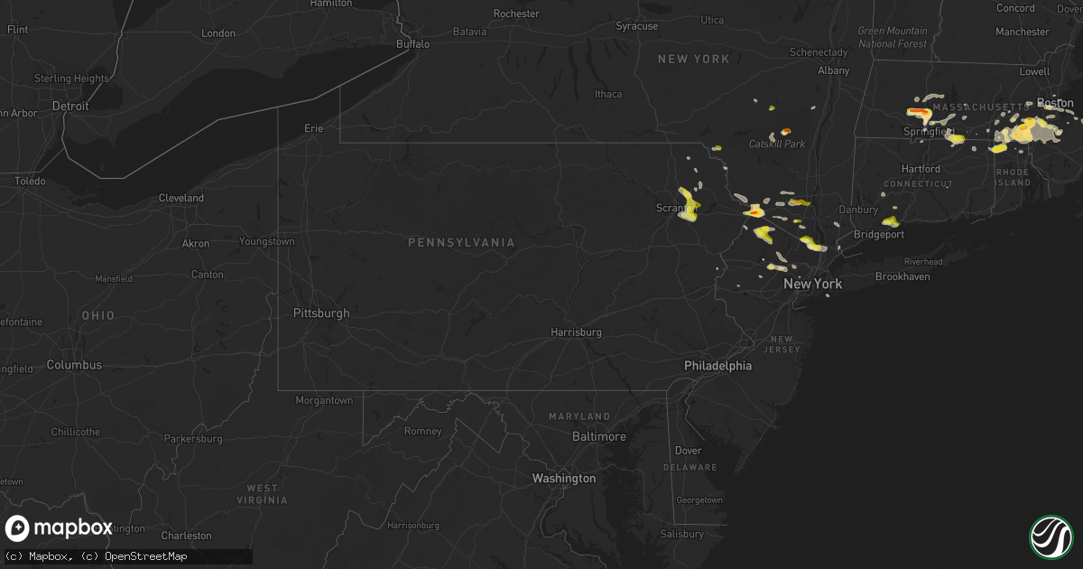
Hail Map in Pennsylvania on June 28, 2020
Get this storm
June 28 map
$229
one time, instant access
Download today. No call, no setup
Keep the $229
Bought the map and want the full workflow? Apply the entire $229 to a subscription within 7 days. None of it is wasted.
Every map, not just this one
This buys you this map. Subscription and you get every map we run, in the markets you choose from a few cities to whole states to nationwide. Plus real-time alerts the moment a storm fires.
Contact data
Name, contact info, occupancy, even credit band for addresses in the footprint. You go from where it hit to who to call.
Become the source they trust
Unlimited branding weather history reports on demand. You already have the documented answer ready for the property owner, and you are the one who showed up with it.
Property data and RoofTrace estimates
Pull up any address you have got, its value and the exact code rules for that jurisdiction, straight from One Click Code. Then RoofTrace estimates the squares, pitch, and roof value, priced the way you price.
Storm reports in Pennsylvania
Pennsylvania
| Date | Description |
|---|---|
| 06/28/20204:35 PM CDT | Downed tree blocking westtown road. |
| 06/28/20204:31 PM CDT | Downed tree blocking general weedon drive. Time estimated from radar. |
| 06/28/20204:15 PM CDT | Mping report of tree limbs down and shingles blown off. |
| 06/28/20202:50 PM CDT | 3 trees down on spring hill road |
| 06/28/20202:37 PM CDT | Trees and wires down |
| 06/28/20202:37 PM CDT | Trees and wires down |
| 06/28/20202:10 PM CDT | A local report indicates 1.00 inch wind near DRINKER |
| 06/28/20202:10 PM CDT | Trees down |
| 06/28/20201:52 PM CDT | A local report indicates 1.00 inch wind near JERMYN |
| 06/28/20201:46 PM CDT | A local report indicates 1.00 inch wind near PLEASANT MOUNT |
| 06/28/20201:43 PM CDT | Trees down near route 247 and petrilak road |
| 06/28/202012:30 PM CDT | Cars damaged in the area. |
| 06/28/202012:14 AM CDT | At 514 PM EDT, a severe thunderstorm was located near East Bangor, or 14 miles north of Easton, moving east at 20 mph. HAZARD...60 mph wind gusts and quarter size hail. SOURCE...Radar indicated. IMPACT...Minor damage to vehicles is possible. Wind damage to roofs, siding, trees, and power lines is possible. Locations impacted include... Hackettstown, Washington, Bangor, High Bridge, Stanhope, Netcong, Belvidere, Oxford, Hope, Glen Gardner, Hampton, Lebanon, East Bangor, Califon, Delaware Water Gap, Brass Castle, Long Valley, Great Meadows-Vienna, Allamuchy-Panther Valley and Pleasant Valley.This includes the following highways... Interstate 78 in New Jersey between mile markers 21 and 23. Interstate 80 in New Jersey between mile markers 2 and 26. |
| 06/28/202012:09 AM CDT | At 509 PM EDT, a severe thunderstorm was located over Marshallton, or near West Chester, moving east at 35 mph. HAZARD...60 mph wind gusts and half dollar size hail. SOURCE...Radar indicated. IMPACT...Minor damage to vehicles is possible. Wind damage to roofs, siding, trees, and power lines is possible. Locations impacted include... West Chester, Chester, Coatesville, Westtown, Downingtown, Swarthmore, Cheyney, Elam, Marshallton, Lima, Trout Lake, Chelsea, Radnor Township, Gradyville, Nether Providence Township, Broomall, Newtown Square, Chester Township, Concordville and Bryn Mawr.This includes the following highways... Interstate 95 in Pennsylvania between mile markers 2 and 6. Interstate 476 in Pennsylvania between mile markers 0 and 13. |
| 06/27/202011:29 PM CDT | At 428 PM EDT, a severe thunderstorm was located near Port Jervis, moving east at 25 mph. HAZARD...60 mph wind gusts and quarter size hail. SOURCE...Radar indicated. IMPACT...Hail damage to vehicles is possible. Expect wind damage to trees and power lines. This severe thunderstorm will be near... Unionville around 440 PM EDT. Warwick and Chester around 500 PM EDT. |
| 06/27/202010:30 PM CDT | At 330 PM EDT, severe thunderstorms were located along a line extending from near Pittston to Greentown, moving southeast at 25 mph. HAZARD...60 mph wind gusts and quarter size hail. SOURCE...Radar indicated. IMPACT...Hail damage to vehicles is expected. Expect wind damage to roofs, siding, and trees. Locations impacted include... Scranton, Wilkes-Barre, Dunmore, Old Forge, Pittston, Taylor, Moosic, Exeter, Swoyersville and Duryea. |
| 06/27/202010:05 PM CDT | At 305 PM EDT, severe thunderstorms were located along a line extending from 7 miles north of Willowemoc to near Narrowsburg, moving southeast at 20 mph. HAZARD...60 mph wind gusts and quarter size hail. SOURCE...Radar indicated. IMPACT...Hail damage to vehicles is expected. Expect wind damage to roofs, siding, and trees. Locations impacted include... Fallsburg, Monticello, Liberty, Bethel, Damascus, Neversink, South Fallsburg, Callicoon, Cochecton and Wurtsboro. |
| 06/27/20209:35 PM CDT | At 235 PM EDT, a severe thunderstorm was located over Carbondale, moving east at 30 mph. HAZARD...60 mph wind gusts and quarter size hail. SOURCE...Radar indicated. IMPACT...Hail damage to vehicles is expected. Expect wind damage to roofs, siding, and trees. Locations impacted include... Carbondale, Archbald, Jermyn, Mayfield, South Canaan, Waymart, Hawley, Vandling, Tompkinsville and Headley. |
| 06/27/20209:02 PM CDT | At 201 PM EDT, a severe thunderstorm was located near Columbia, or 17 miles northeast of Easton, moving east at 25 mph. HAZARD...60 mph wind gusts and quarter size hail. SOURCE...Radar indicated. IMPACT...Minor damage to vehicles is possible. Wind damage to roofs, siding, trees, and power lines is possible. Locations impacted include... Hopatcong, Hackettstown, Blairstown, Mount Arlington, Stanhope, Netcong, Belvidere, Oxford, Hope, Chester, Delaware Water Gap, Andover, Great Meadows-Vienna, Allamuchy-Panther Valley, Succasunna, Succasunna-Kenvil, Greendell, Long Valley, Columbia and Budd Lake.This includes Interstate 80 in New Jersey between mile markers 2 and30. |
| 06/27/20208:39 PM CDT | At 138 PM EDT, a severe thunderstorm was located near Unionville, or near Port Jervis, moving east at 15 mph. HAZARD...60 mph wind gusts and golf ball size hail. SOURCE...Radar indicated. IMPACT...Minor damage to vehicles is possible. Wind damage to roofs, siding, trees, and power lines is possible. This severe thunderstorm will be near... Unionville around 150 PM EDT. |
| 06/27/20208:22 PM CDT | At 122 PM EDT, a severe thunderstorm was located over Hainesville, or near Montague, moving east at 20 mph. HAZARD...60 mph wind gusts and quarter size hail. SOURCE...Radar indicated. IMPACT...Minor damage to vehicles is possible. Wind damage to roofs, siding, trees, and power lines is possible. Locations impacted include... Montague, Franklin, Hamburg, Sussex, Branchville, High Point, Pellettown, Highland Lake, Vernon Valley, Hainesville and Crandon Lakes. |
All States Impacted by Hail Map on June 28, 2020
Cities Impacted by Hail Map on June 28, 2020
- Carpio, ND
- Lansford, ND
- Millington, MD
- Chestertown, MD
- Worton, MD
- Still Pond, MD
- Sudlersville, MD
- Crumpton, MD
- Kennedyville, MD
- Mandan, ND
- Napoleon, ND
- Hill City, SD
- Granville, ND
- Surrey, ND
- Norwich, ND
- Casper, WY
- West Haven, CT
- Orange, CT
- Shelton, CT
- Milford, CT
- Stratford, CT
- Mud Butte, SD
- Alfred, ME
- Glenwood City, WI
- Lake Crystal, MN
- Courtland, MN
- Midland, SD
- Wilton, ND
- Scenic, SD
- Kyle, SD
- Wharton, NJ
- Lake Hopatcong, NJ
- Clayton, AL
- Louisville, AL
- Montvale, NJ
- Westwood, NJ
- Orangeburg, NY
- Tappan, NY
- Pearl River, NY
- Moorcroft, WY
- Aladdin, WY
- Sundance, WY
- Belle Fourche, SD
- Beulah, WY
- Rozet, WY
- Gillette, WY
- Coleharbor, ND
- Riverdale, ND
- Garrison, ND
- Saint Paul, MN
- Montgomery, MN
- New Prague, MN
- Baldwin, ND
- Bismarck, ND
- Moscow, PA
- Gouldsboro, PA
- Lake Ariel, PA
- Custer, SD
- Keystone, SD
- Rapid City, SD
- Allen, SD
- Center, ND
- Newell, SD
- Buffalo, SD
- Lodgepole, SD
- Ralph, SD
- Ludlow, SD
- Reva, SD
- Stockholm, NJ
- Branchville, NJ
- Highland Lakes, NJ
- Glenwood, NJ
- Augusta, NJ
- Lafayette, NJ
- Vernon, NJ
- Franklin, NJ
- Hamburg, NJ
- Sussex, NJ
- Solen, ND
- Flasher, ND
- Denville, NJ
- Randolph, NJ
- Morris Plains, NJ
- Deadwood, SD
- Black Hawk, SD
- Nemo, SD
- Piedmont, SD
- Layton, NJ
- Adairville, KY
- Lead, SD
- Sturgis, SD
- Phoenicia, NY
- Dupree, SD
- Nisland, SD
- Faith, SD
- Meadow, SD
- Pierre, SD
- Saint Ansgar, IA
- Lyle, MN
- Fullerton, ND
- Lamoure, ND
- Downing, WI
- Clear Lake, WI
- Porcupine, SD
- Interior, SD
- Kadoka, SD
- Wanblee, SD
- Pine Ridge, SD
- Thompson, PA
- Olivia, MN
- Bird Island, MN
- Medway, MA
- Bellingham, MA
- Franklin, MA
- Kintyre, ND
- Philip, SD
- Pembroke, KY
- Hopkinsville, KY
- Wakpala, SD
- Millis, MA
- Milford, MA
- Cannon Falls, MN
- Dennison, MN
- Hampton, MN
- Farmington, MN
- Welch, MN
- Northfield, MN
- Hastings, MN
- Randolph, MN
- Sparrow Bush, NY
- Milford, PA
- Port Jervis, NY
- Huguenot, NY
- Montague, NJ
- Matamoras, PA
- Southfields, NY
- Pomona, NY
- Stony Point, NY
- Kaycee, WY
- Washburn, ND
- Martin, SD
- New Salem, ND
- Stewartville, MN
- Racine, MN
- Spring Valley, MN
- Grand Meadow, MN
- Parsippany, NJ
- Verona, ND
- Inver Grove Heights, MN
- Mcminnville, TN
- McKenzie, AL
- Evergreen, AL
- Georgiana, AL
- Fort Yates, ND
- Saint Anthony, ND
- Union Center, SD
- Forbes, ND
- Chatfield, MN
- Union, NH
- Deering, ND
- Minot, ND
- Upham, ND
- Velva, ND
- Bantry, ND
- Jermyn, PA
- Archbald, PA
- Carbondale, PA
- River Falls, WI
- Ellsworth, WI
- Bay City, WI
- Beldenville, WI
- Hager City, WI
- Elmwood, WI
- Maiden Rock, WI
- Spring Valley, WI
- Monson, MA
- Wales, MA
- Stafford Springs, CT
- Appleton, MN
- Opp, AL
- Winthrop, MN
- Gibbon, MN
- Steele, ND
- Berthold, ND
- Burlington, ND
- Buffalo, ND
- Scituate, MA
- Ocklawaha, FL
- Silver Springs, FL
- Fort McCoy, FL
- Long Eddy, NY
- Hancock, NY
- Fort Pierre, SD
- Seville, FL
- Pierson, FL
- Selfridge, ND
- Stanton, ND
- Cannon Ball, ND
- Shields, ND
- Danvers, MN
- Spring Valley, NY
- Suffern, NY
- Monsey, NY
- Maxbass, ND
- Park Ridge, NJ
- Sparkill, NY
- Piermont, NY
- Northvale, NJ
- Blauvelt, NY
- Nanuet, NY
- Nyack, NY
- Butler, AL
- Devils Tower, WY
- Easthampton, MA
- Northampton, MA
- Southampton, MA
- South Hadley, MA
- Hadley, MA
- Holyoke, MA
- Huntington, MA
- Florence, MA
- Rochester, MN
- Oronoco, MN
- Alzada, MT
- Trenton, KY
- Oshkosh, NE
- Dalton, MN
- Webster, MN
- Lonsdale, MN
- Savage, MN
- Rock Island, TN
- Holland, MA
- Hampden, MA
- Cerulean, KY
- McLaughlin, SD
- Northwood, IA
- Elkton, MN
- Adams, MN
- Kensett, IA
- Dexter, MN
- Rose Creek, MN
- Austin, MN
- Menomonie, WI
- Boyceville, WI
- Knapp, WI
- Gaylord, MN
- New Ulm, MN
- Nicollet, MN
- Saint Peter, MN
- Hanska, MN
- Madelia, MN
- Lafayette, MN
- Alton, NH
- Wolfeboro, NH
- Edgemont, SD
- Hermosa, SD
- Hazelton, ND
- Mendham, NJ
- Chester, NJ
- Hayes, SD
- Whitinsville, MA
- Sutton, MA
- Uxbridge, MA
- Harrisville, RI
- Long Valley, SD
- Johnston, SC
- Kilkenny, MN
- Faribault, MN
- Warsaw, MN
- Morristown, MN
- Waterville, MN
- North Smithfield, RI
- Aberdeen, SD
- Eagle Butte, SD
- Minneapolis, MN
- Burnsville, MN
- Lincoln, RI
- Smithfield, RI
- Granby, MA
- Chicopee, MA
- Glenburn, ND
- Brockton, MA
- Afton, MN
- Midway, AL
- Elkton, KY
- Oak Grove, KY
- Boyes, MT
- Hammond, MT
- Leola, SD
- Cohasset, MA
- Ludlow, MA
- Robinson, ND
- Caldwell, NJ
- Pine Brook, NJ
- Mountain Lakes, NJ
- Dover, NJ
- Whippany, NJ
- Lake Hiawatha, NJ
- Fairfield, NJ
- Montville, NJ
- Roseland, NJ
- Mount Tabor, NJ
- Rockaway, NJ
- East Hanover, NJ
- Shakopee, MN
- Prior Lake, MN
- Hobart, NY
- South Kortright, NY
- Guthrie, KY
- Mapleville, RI
- Putnam, CT
- Chepachet, RI
- Thompson, CT
- Pascoag, RI
- Oakland, RI
- Cologne, MN
- Carver, MN
- Chaska, MN
- Jordan, MN
- Prompton, PA
- Waymart, PA
- Gaffney, SC
- West Springfield, MA
- Ellendale, ND
- Waseca, MN
- Franklin, MN
- Chestnut Hill, MA
- Roxbury, MA
- Brookline, MA
- Jamaica Plain, MA
- Driscoll, ND
- Braddock, ND
- Medford, WI
- Roebuck, SC
- Spartanburg, SC
- Oakes, ND
- Lewiston, MN
- Winona, MN
- Walpole, MA
- Dover, MA
- Norwood, MA
- Sharon, MA
- Westwood, MA
- Canton, MA
- East Walpole, MA
- Blackstone, MA
- Southbridge, MA
- Letohatchee, AL
- Linton, ND
- Acton, ME
- East Wakefield, NH
- Enderlin, ND
- Belvidere, SD
- Sherborn, MA
- Morris, MN
- Donnelly, MN
- Fort Deposit, AL
- Joice, IA
- Pleasant Mount, PA
- Hector, MN
- Ashby, NE
- Nichols, SC
- Avon, MA
- Lapine, AL
- Hudson, WI
- Mankato, MN
- Cleveland, MN
- Le Center, MN
- Le Sueur, MN
- Madison Lake, MN
- Kasota, MN
- Minot Afb, ND
- Des Lacs, ND
- Newburg, ND
- Nome, ND
- Fingal, ND
- Mendota, MN
- Lakeville, MN
- Elko New Market, MN
- Hopkinton, MA
- Ashland, MA
- Upton, MA
- Scranton, PA
- Agar, SD
- Rib Lake, WI
- Holliston, MA
- Eddyville, IL
- Stirum, ND
- Deer Park, WI
- Spearfish, SD
- Charlotte, NC
- Hecla, SD
- Ware, MA
- Three Rivers, MA
- Palmer, MA
- Belchertown, MA
- Wilbraham, MA
- Bondsville, MA
- Wishek, ND
- Gurley, NE
- Florien, LA
- Graceville, MN
- Dorchester, MA
- Brighton, MA
- Hull, MA
- Roslindale, MA
- Quincy, MA
- Dorchester Center, MA
- Newton Center, MA
- Roxbury Crossing, MA
- Boston, MA
- Ninety Six, SC
- Pepin, WI
- Trempealeau, WI
- Saint Charles, MN
- Galesville, WI
- Rollingstone, MN
- Eyota, MN
- Altura, MN
- Lake Mills, IA
- Dodge, WI
- Minnesota City, MN
- Hanlontown, IA
- Fountain City, WI
- Utica, MN
- Dover, MN
- Hammond, WI
- Wrentham, MA
- Norfolk, MA
- Abington, MA
- Whitman, MA
- Millville, MA
- Hopedale, MA
- Stoughton, MA
- Mendon, MA
- Woonsocket, RI
- Medfield, MA
- Northbridge, MA
- Plainville, MA
- Cumberland, RI
- Clara City, MN
- Raymond, MN
- Capitol, MT
- Woodville, WI
- Winthrop, MA
- Wing, AL
- Trail City, SD
- Stewart, MN
- Buffalo Lake, MN
- Janesville, MN
- Souris, ND
- Hoffman, MN
- Herman, MN
- Prescott, WI
- Baldwin, WI
- Red Wing, MN
- Roberts, WI
- Monroe, NY
- Marion, LA
- Washingtonville, NY
- Campbell Hall, NY
- Rock Tavern, NY
- Hingham, MA
- Norwell, MA
- Lancaster, SC
- Waxhaw, NC
- Glenham, SD
- Dawson, ND
- Houghton, SD
- Columbia, SD
- Katonah, NY
- Bedford Hills, NY
- Tompkinsville, KY
- Kenyon, MN
- Wanamingo, MN
- Andalusia, AL
- Murdock, MN
- Bastrop, LA
- Crossett, AR
- Bethany, CT
- Belle Plaine, MN
- Sanbornville, NH
- Shapleigh, ME
- West Newfield, ME
- South Walpole, MA
- East Bridgewater, MA
- Holbrook, MA
- Glendale, RI
- Mansfield, MA
- Norton, MA
- Randolph, MA
- West Bridgewater, MA
- North Easton, MA
- Douglas, MA
- South Easton, MA
- Foxboro, MA
- Greenville, AL
- Valley City, ND
- Leeds, NY
- Freehold, NY
- Cairo, NY
- Montclair, NJ
- Little Falls, NJ
- Cedar Grove, NJ
- Chichester, NY
- Castleberry, AL
- Belmont, NC
- Yulan, NY
- Eldred, NY
- Narrowsburg, NY
- Pond Eddy, NY
- Highland Lake, NY
- Glen Spey, NY
- Barryville, NY
- Suffield, CT
- Correll, MN
- Odessa, MN
- Ortonville, MN
- Bloomingburg, NY
- Circleville, NY
- Pine Bush, NY
- Montgomery, NY
- Middletown, NY
- Exline, IA
- Mendon, IL
- Fowler, IL
- Adolphus, KY
- Hancock, MN
- Mondovi, WI
- Alma, WI
- Eufaula, AL
- Hannaford, ND
- Big Springs, NE
- Moravia, IA
- Mobridge, SD
- Little Eagle, SD
- Gilbertville, MA
- New Braintree, MA
- Millbury, MA
- Roxbury, NY
- Honoraville, AL
- Blenheim, SC
- Bennettsville, SC
- Woodstock, CT
- Westmoreland, TN
- Dedham, MA
- Hyde Park, MA
- Milton, MA
- Byron, MN
- Pine Island, MN
- Kellogg, MN
- Millville, MN
- Plainview, MN
- Elgin, MN
- Pikeville, TN
- Bangor, PA
- Rosemount, MN
- Banks, AL
- Rogers, MN
- Greenwich, CT
- Port Chester, NY
- Camp Crook, SD
- Union Springs, AL
- Box Elder, SD
- Selby, SD
- Gettysburg, SD
- Cuddebackville, NY
- Otisville, NY
- Westbrookville, NY
- Princeton, KY
- Dawson Springs, KY
- Cottage Grove, MN
- Saint Paul Park, MN
- Newport, MN
- Amherst, NH
- Milford, NH
- Malden, MA
- Everett, MA
- Haydenville, MA
- Stillwater, MN
- Shandaken, NY
- Tracy, IA
- Knoxville, IA
- Crofton, KY
- Dazey, ND
- Marine On Saint Croix, MN
- Florida, NY
- Goshen, NY
- Warwick, NY
- Chester, NY
- Williamsburg, MA
- Pollock, SD
- Belgrade, MN
- Fiskdale, MA
- Lodgepole, NE
- Julesburg, CO
- Frederick, SD
- West Brookfield, MA
- Warren, MA
- Forest Hill, MD
- Fort Mill, SC
- Tappen, ND
- Lumpkin, GA
- Morris, GA
- Seale, AL
- Pittsview, AL
- Onida, SD
- Dundas, MN
- Kearny, NJ
- Newark, NJ
- Blomkest, MN
- Danube, MN
- Page, ND
- Ramer, AL
- Grady, AL
- Springfield, MA
- Jessup, PA
- Olyphant, PA
- Claremont, SD
- North Hatfield, MA
- West Hatfield, MA
- Sunderland, MA
- Hatfield, MA
- Leverett, MA
- South Deerfield, MA
- Shutesbury, MA
- Amherst, MA
- Ooltewah, TN
- Jonesville, SC
- Montevideo, MN
- Maynard, MN
- Scottsville, KY
- Callicoon, NY
- Damascus, PA
- Topeka, KS
- Maple Hill, KS
- Harveyville, KS
- Mountain Lake, MN
- Prinsburg, MN
- Millry, AL
- Frankville, AL
- Middlebury, CT
- Woodbury, CT
- Benson, MN
- Barrett, MN
- Dale, TX
- Westtown, NY
- Amherst, SD
- Boonton, NJ
- Lincoln Park, NJ
- Butler, NJ
- Towaco, NJ
- Far Rockaway, NY
- Arverne, NY
- Cogswell, ND
- Saluda, SC
- Chappells, SC
- Arthur, NE
- Mound City, SD
- Colchester, CT
- West Newton, MA
- Auburndale, MA
- Newtonville, MA
- Waltham, MA
- Waban, MA
- Palisades, NY
- Irvington, NY
- Downing, MO
- Arkville, NY
- Big Indian, NY
- Amery, WI
- West Concord, MN
- Colfax, WI
- Lakeland, MN
- Wabasha, MN
- Woodstock Valley, CT
- Westborough, MA
- Fredonia, ND
- Kulm, ND
- Prairie City, SD
- Hoven, SD
- Milton, NH
- Milton Mills, NH
- Chidester, AR
- North Grafton, MA
- Shrewsbury, MA
- Oxford, MA
- Glen Gardner, NJ
- New Richmond, WI
- Fitzpatrick, AL
- Oriska, ND
- Westboro, WI
- Nerstrand, MN
- Cyrus, MN
- Elmsford, NY
- West Nyack, NY
- Tarrytown, NY
- White Plains, NY
- Dobbs Ferry, NY
- Ardsley, NY
- Hartsdale, NY
- Britton, SD
- Glenwood, MO
- Queen City, MO
- Sudbury, MA
- Weston, MA
- Wayland, MA
- Chattanooga, TN
- Medford, MN
- Owatonna, MN
- Carlisle, SC
- Buffalo, SC
- Union, SC
- Batesburg, SC
- Leesville, SC
- Mullins, SC
- Florence, SC
- Sellers, SC
- Darlington, SC
- Marion, SC
- Green Sea, SC
- Tabor City, NC
- Nakina, NC
- Loris, SC
- Derby, CT
- Woodbridge, CT
- Bridgton, ME
- Sebago, ME
- Naples, ME
- Denmark, ME
- Hiram, ME
- Fishs Eddy, NY
- Salisbury Mills, NY
- Maybrook, NY
- New Windsor, NY
- Cornwall, NY
- Prattsville, NY
- Harriman, NY
- Lanesville, NY
- New City, NY
- Allensville, KY
- Ekalaka, MT
- Batesland, SD
- Highland Home, AL
- Montgomery, AL
- Richland, GA
- Preston, GA
- Lewellen, NE
- Mohall, ND


