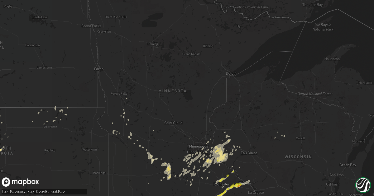
Hail Map in Minnesota on June 28, 2020
Get this storm
June 28 map
$229
one time, instant access
Download today. No call, no setup
Keep the $229
Bought the map and want the full workflow? Apply the entire $229 to a subscription within 7 days. None of it is wasted.
Every map, not just this one
This buys you this map. Subscription and you get every map we run, in the markets you choose from a few cities to whole states to nationwide. Plus real-time alerts the moment a storm fires.
Contact data
Name, contact info, occupancy, even credit band for addresses in the footprint. You go from where it hit to who to call.
Become the source they trust
Unlimited branding weather history reports on demand. You already have the documented answer ready for the property owner, and you are the one who showed up with it.
Property data and RoofTrace estimates
Pull up any address you have got, its value and the exact code rules for that jurisdiction, straight from One Click Code. Then RoofTrace estimates the squares, pitch, and roof value, priced the way you price.
Storm reports in Minnesota
Minnesota
| Date | Description |
|---|---|
| 06/28/20206:40 PM CDT | Delayed report - 1.15 inches of rain too. |
| 06/28/20206:40 PM CDT | Delayed report. |
| 06/28/20205:04 PM CDT | Relayed via social media. Approximate location. |
| 06/28/20205:00 PM CDT | Viewer report from kaal of golf ball sized hail. Time estimated based on radar. |
| 06/28/20204:55 PM CDT | 4-6 inch tree branches down. Time estimated by radar. |
| 06/28/20206:30 AM CDT | At 1130 PM CDT, a severe thunderstorm was located over Lafayette, or 11 miles northeast of New Ulm, moving north at 20 mph. HAZARD...60 mph wind gusts and half dollar size hail. SOURCE...Radar indicated. IMPACT...Hail damage to vehicles is expected. Expect wind damage to roofs, siding, and trees. Locations impacted include... Gaylord, Winthrop, Lafayette, New Sweden and Klossner. |
| 06/28/20205:52 AM CDT | At 1052 PM CDT, a severe thunderstorm was located near Nicollet, or 11 miles southeast of New Ulm, moving northeast at 20 mph. HAZARD...Ping pong ball size hail and 60 mph wind gusts. SOURCE...Radar indicated. IMPACT...People and animals outdoors will be injured. Expect hail damage to roofs, siding, windows, and vehicles. Expect wind damage to roofs, siding, and trees. Locations impacted include... Nicollet, Courtland, Judson and Oshawa. This includes U.S. Highway 14 between mile markers 111 and 121. |
| 06/28/20202:26 AM CDT | At 725 PM CDT, a severe thunderstorm was located over St. Charles, or 19 miles east of Rochester, moving northeast at 20 mph. HAZARD...60 mph wind gusts and quarter size hail. SOURCE...Trained weather spotters reported quarter size hail in St. Charles. IMPACT...Hail damage to vehicles is expected. Expect wind damage to roofs, siding, and trees. This severe thunderstorm will be near... Lewiston around 750 PM CDT. Altura around 755 PM CDT. Stockton around 805 PM CDT. Rollingstone around 810 PM CDT. Winona and Goodview around 820 PM CDT. Fountain City around 825 PM CDT.Other locations impacted by this severe thunderstorm includeWhitewater State Park, Lock And Dam 5 A, Elba, Whitman, County Roads28 And 31, Minnesota City and Utica. |
| 06/28/20201:33 AM CDT | At 633 PM CDT, a severe thunderstorm was located near Oronoco, or near Rochester, moving northeast at 20 mph. HAZARD...60 mph wind gusts and half dollar size hail. SOURCE...Radar indicated. IMPACT...Hail damage to vehicles is expected. Expect wind damage to roofs, siding, and trees. This severe thunderstorm will remain over mainly rural areas of north central Olmsted and southwestern Wabasha Counties, including the following locations... South Troy, Jarrett, Ringe, County Roads 79 And 2, Rattelsnake Point, Potsdam and Highway 52 And County 14. |
| 06/28/20201:28 AM CDT | At 628 PM CDT, a severe thunderstorm was located near Stewartville, or 15 miles south of Rochester, moving northeast at 25 mph. HAZARD...60 mph wind gusts and half dollar size hail. SOURCE...Radar indicated. IMPACT...Hail damage to vehicles is expected. Expect wind damage to roofs, siding, and trees. This severe thunderstorm will be near... Chatfield around 655 PM CDT. Eyota around 705 PM CDT. Dover around 710 PM CDT.Other locations impacted by this severe thunderstorm includePredmore, County Roads 9 And 10, I 90 Exit 218, I 90 Exit 229, I 90Exit 224, County Roads 137 And 136 and Fillmore. |
| 06/28/202012:43 AM CDT | At 542 PM CDT, a severe thunderstorm was located near Grand Meadow, or 13 miles east of Austin, moving northeast at 25 mph. HAZARD...Ping pong ball size hail and 60 mph wind gusts. SOURCE...Radar indicated. IMPACT...People and animals outdoors will be injured. Expect hail damage to roofs, siding, windows, and vehicles. Expect wind damage to roofs, siding, and trees. This severe thunderstorm will be near... Grand Meadow around 600 PM CDT. Spring Valley around 615 PM CDT.Other locations impacted by this severe thunderstorm include I 90Exit 209, Highways 63 And 16, Hamilton, I 90 Exit 193, High Forest, I90 Exit 205 and Dexter. |
| 06/27/202011:49 PM CDT | At 448 PM CDT, a severe thunderstorm was located near London, or 8 miles east of Northwood, moving northeast at 30 mph. HAZARD...Ping pong ball size hail and 60 mph wind gusts. SOURCE...Radar indicated. IMPACT...People and animals outdoors will be injured. Expect hail damage to roofs, siding, windows, and vehicles. Expect wind damage to roofs, siding, and trees. This severe thunderstorm will be near... Lyle around 500 PM CDT. Rose Creek around 520 PM CDT. Adams around 525 PM CDT.Other locations impacted by this severe thunderstorm include Meyer,Toeterville, County Roads 56 And 5, Otranto, Otranto Park, I 90 Exit187 and Elkton. |
| 06/27/202011:19 PM CDT | At 419 PM CDT, a severe thunderstorm was located over Northwood, moving northeast at 30 mph. HAZARD...60 mph wind gusts and quarter size hail. SOURCE...Radar indicated. IMPACT...Hail damage to vehicles is expected. Expect wind damage to roofs, siding, and trees. Locations impacted include... Northwood, Kensett, Grafton, Bolan and Northwood Municipal. This includes Interstate 35 between mile markers 209 and 218. |
| 06/27/20208:54 PM CDT | 2nd tornado from june 28th documented. Lasted approx 2 minutes and was low end ef0. |
| 06/27/20208:45 PM CDT | Preliminary report. |
| 06/27/20208:39 PM CDT | Preliminary report. |
| 06/27/20208:12 PM CDT | . |
| 06/27/20208:10 PM CDT | Delayed report. Large branches down and some shingles removed from a house in lewiston. Time estimated from radar. |
| 06/27/20208:10 PM CDT | Large tree branches down. |
| 06/27/20207:50 PM CDT | Quarter size hail 3 s of altura... Mn. Time estimated by radar. |
| 06/27/20207:23 PM CDT | . |
All States Impacted by Hail Map on June 28, 2020
Cities Impacted by Hail Map on June 28, 2020
- Carpio, ND
- Lansford, ND
- Millington, MD
- Chestertown, MD
- Worton, MD
- Still Pond, MD
- Sudlersville, MD
- Crumpton, MD
- Kennedyville, MD
- Mandan, ND
- Napoleon, ND
- Hill City, SD
- Granville, ND
- Surrey, ND
- Norwich, ND
- Casper, WY
- West Haven, CT
- Orange, CT
- Shelton, CT
- Milford, CT
- Stratford, CT
- Mud Butte, SD
- Alfred, ME
- Glenwood City, WI
- Lake Crystal, MN
- Courtland, MN
- Midland, SD
- Wilton, ND
- Scenic, SD
- Kyle, SD
- Wharton, NJ
- Lake Hopatcong, NJ
- Clayton, AL
- Louisville, AL
- Montvale, NJ
- Westwood, NJ
- Orangeburg, NY
- Tappan, NY
- Pearl River, NY
- Moorcroft, WY
- Aladdin, WY
- Sundance, WY
- Belle Fourche, SD
- Beulah, WY
- Rozet, WY
- Gillette, WY
- Coleharbor, ND
- Riverdale, ND
- Garrison, ND
- Saint Paul, MN
- Montgomery, MN
- New Prague, MN
- Baldwin, ND
- Bismarck, ND
- Moscow, PA
- Gouldsboro, PA
- Lake Ariel, PA
- Custer, SD
- Keystone, SD
- Rapid City, SD
- Allen, SD
- Center, ND
- Newell, SD
- Buffalo, SD
- Lodgepole, SD
- Ralph, SD
- Ludlow, SD
- Reva, SD
- Stockholm, NJ
- Branchville, NJ
- Highland Lakes, NJ
- Glenwood, NJ
- Augusta, NJ
- Lafayette, NJ
- Vernon, NJ
- Franklin, NJ
- Hamburg, NJ
- Sussex, NJ
- Solen, ND
- Flasher, ND
- Denville, NJ
- Randolph, NJ
- Morris Plains, NJ
- Deadwood, SD
- Black Hawk, SD
- Nemo, SD
- Piedmont, SD
- Layton, NJ
- Adairville, KY
- Lead, SD
- Sturgis, SD
- Phoenicia, NY
- Dupree, SD
- Nisland, SD
- Faith, SD
- Meadow, SD
- Pierre, SD
- Saint Ansgar, IA
- Lyle, MN
- Fullerton, ND
- Lamoure, ND
- Downing, WI
- Clear Lake, WI
- Porcupine, SD
- Interior, SD
- Kadoka, SD
- Wanblee, SD
- Pine Ridge, SD
- Thompson, PA
- Olivia, MN
- Bird Island, MN
- Medway, MA
- Bellingham, MA
- Franklin, MA
- Kintyre, ND
- Philip, SD
- Pembroke, KY
- Hopkinsville, KY
- Wakpala, SD
- Millis, MA
- Milford, MA
- Cannon Falls, MN
- Dennison, MN
- Hampton, MN
- Farmington, MN
- Welch, MN
- Northfield, MN
- Hastings, MN
- Randolph, MN
- Sparrow Bush, NY
- Milford, PA
- Port Jervis, NY
- Huguenot, NY
- Montague, NJ
- Matamoras, PA
- Southfields, NY
- Pomona, NY
- Stony Point, NY
- Kaycee, WY
- Washburn, ND
- Martin, SD
- New Salem, ND
- Stewartville, MN
- Racine, MN
- Spring Valley, MN
- Grand Meadow, MN
- Parsippany, NJ
- Verona, ND
- Inver Grove Heights, MN
- Mcminnville, TN
- McKenzie, AL
- Evergreen, AL
- Georgiana, AL
- Fort Yates, ND
- Saint Anthony, ND
- Union Center, SD
- Forbes, ND
- Chatfield, MN
- Union, NH
- Deering, ND
- Minot, ND
- Upham, ND
- Velva, ND
- Bantry, ND
- Jermyn, PA
- Archbald, PA
- Carbondale, PA
- River Falls, WI
- Ellsworth, WI
- Bay City, WI
- Beldenville, WI
- Hager City, WI
- Elmwood, WI
- Maiden Rock, WI
- Spring Valley, WI
- Monson, MA
- Wales, MA
- Stafford Springs, CT
- Appleton, MN
- Opp, AL
- Winthrop, MN
- Gibbon, MN
- Steele, ND
- Berthold, ND
- Burlington, ND
- Buffalo, ND
- Scituate, MA
- Ocklawaha, FL
- Silver Springs, FL
- Fort McCoy, FL
- Long Eddy, NY
- Hancock, NY
- Fort Pierre, SD
- Seville, FL
- Pierson, FL
- Selfridge, ND
- Stanton, ND
- Cannon Ball, ND
- Shields, ND
- Danvers, MN
- Spring Valley, NY
- Suffern, NY
- Monsey, NY
- Maxbass, ND
- Park Ridge, NJ
- Sparkill, NY
- Piermont, NY
- Northvale, NJ
- Blauvelt, NY
- Nanuet, NY
- Nyack, NY
- Butler, AL
- Devils Tower, WY
- Easthampton, MA
- Northampton, MA
- Southampton, MA
- South Hadley, MA
- Hadley, MA
- Holyoke, MA
- Huntington, MA
- Florence, MA
- Rochester, MN
- Oronoco, MN
- Alzada, MT
- Trenton, KY
- Oshkosh, NE
- Dalton, MN
- Webster, MN
- Lonsdale, MN
- Savage, MN
- Rock Island, TN
- Holland, MA
- Hampden, MA
- Cerulean, KY
- McLaughlin, SD
- Northwood, IA
- Elkton, MN
- Adams, MN
- Kensett, IA
- Dexter, MN
- Rose Creek, MN
- Austin, MN
- Menomonie, WI
- Boyceville, WI
- Knapp, WI
- Gaylord, MN
- New Ulm, MN
- Nicollet, MN
- Saint Peter, MN
- Hanska, MN
- Madelia, MN
- Lafayette, MN
- Alton, NH
- Wolfeboro, NH
- Edgemont, SD
- Hermosa, SD
- Hazelton, ND
- Mendham, NJ
- Chester, NJ
- Hayes, SD
- Whitinsville, MA
- Sutton, MA
- Uxbridge, MA
- Harrisville, RI
- Long Valley, SD
- Johnston, SC
- Kilkenny, MN
- Faribault, MN
- Warsaw, MN
- Morristown, MN
- Waterville, MN
- North Smithfield, RI
- Aberdeen, SD
- Eagle Butte, SD
- Minneapolis, MN
- Burnsville, MN
- Lincoln, RI
- Smithfield, RI
- Granby, MA
- Chicopee, MA
- Glenburn, ND
- Brockton, MA
- Afton, MN
- Midway, AL
- Elkton, KY
- Oak Grove, KY
- Boyes, MT
- Hammond, MT
- Leola, SD
- Cohasset, MA
- Ludlow, MA
- Robinson, ND
- Caldwell, NJ
- Pine Brook, NJ
- Mountain Lakes, NJ
- Dover, NJ
- Whippany, NJ
- Lake Hiawatha, NJ
- Fairfield, NJ
- Montville, NJ
- Roseland, NJ
- Mount Tabor, NJ
- Rockaway, NJ
- East Hanover, NJ
- Shakopee, MN
- Prior Lake, MN
- Hobart, NY
- South Kortright, NY
- Guthrie, KY
- Mapleville, RI
- Putnam, CT
- Chepachet, RI
- Thompson, CT
- Pascoag, RI
- Oakland, RI
- Cologne, MN
- Carver, MN
- Chaska, MN
- Jordan, MN
- Prompton, PA
- Waymart, PA
- Gaffney, SC
- West Springfield, MA
- Ellendale, ND
- Waseca, MN
- Franklin, MN
- Chestnut Hill, MA
- Roxbury, MA
- Brookline, MA
- Jamaica Plain, MA
- Driscoll, ND
- Braddock, ND
- Medford, WI
- Roebuck, SC
- Spartanburg, SC
- Oakes, ND
- Lewiston, MN
- Winona, MN
- Walpole, MA
- Dover, MA
- Norwood, MA
- Sharon, MA
- Westwood, MA
- Canton, MA
- East Walpole, MA
- Blackstone, MA
- Southbridge, MA
- Letohatchee, AL
- Linton, ND
- Acton, ME
- East Wakefield, NH
- Enderlin, ND
- Belvidere, SD
- Sherborn, MA
- Morris, MN
- Donnelly, MN
- Fort Deposit, AL
- Joice, IA
- Pleasant Mount, PA
- Hector, MN
- Ashby, NE
- Nichols, SC
- Avon, MA
- Lapine, AL
- Hudson, WI
- Mankato, MN
- Cleveland, MN
- Le Center, MN
- Le Sueur, MN
- Madison Lake, MN
- Kasota, MN
- Minot Afb, ND
- Des Lacs, ND
- Newburg, ND
- Nome, ND
- Fingal, ND
- Mendota, MN
- Lakeville, MN
- Elko New Market, MN
- Hopkinton, MA
- Ashland, MA
- Upton, MA
- Scranton, PA
- Agar, SD
- Rib Lake, WI
- Holliston, MA
- Eddyville, IL
- Stirum, ND
- Deer Park, WI
- Spearfish, SD
- Charlotte, NC
- Hecla, SD
- Ware, MA
- Three Rivers, MA
- Palmer, MA
- Belchertown, MA
- Wilbraham, MA
- Bondsville, MA
- Wishek, ND
- Gurley, NE
- Florien, LA
- Graceville, MN
- Dorchester, MA
- Brighton, MA
- Hull, MA
- Roslindale, MA
- Quincy, MA
- Dorchester Center, MA
- Newton Center, MA
- Roxbury Crossing, MA
- Boston, MA
- Ninety Six, SC
- Pepin, WI
- Trempealeau, WI
- Saint Charles, MN
- Galesville, WI
- Rollingstone, MN
- Eyota, MN
- Altura, MN
- Lake Mills, IA
- Dodge, WI
- Minnesota City, MN
- Hanlontown, IA
- Fountain City, WI
- Utica, MN
- Dover, MN
- Hammond, WI
- Wrentham, MA
- Norfolk, MA
- Abington, MA
- Whitman, MA
- Millville, MA
- Hopedale, MA
- Stoughton, MA
- Mendon, MA
- Woonsocket, RI
- Medfield, MA
- Northbridge, MA
- Plainville, MA
- Cumberland, RI
- Clara City, MN
- Raymond, MN
- Capitol, MT
- Woodville, WI
- Winthrop, MA
- Wing, AL
- Trail City, SD
- Stewart, MN
- Buffalo Lake, MN
- Janesville, MN
- Souris, ND
- Hoffman, MN
- Herman, MN
- Prescott, WI
- Baldwin, WI
- Red Wing, MN
- Roberts, WI
- Monroe, NY
- Marion, LA
- Washingtonville, NY
- Campbell Hall, NY
- Rock Tavern, NY
- Hingham, MA
- Norwell, MA
- Lancaster, SC
- Waxhaw, NC
- Glenham, SD
- Dawson, ND
- Houghton, SD
- Columbia, SD
- Katonah, NY
- Bedford Hills, NY
- Tompkinsville, KY
- Kenyon, MN
- Wanamingo, MN
- Andalusia, AL
- Murdock, MN
- Bastrop, LA
- Crossett, AR
- Bethany, CT
- Belle Plaine, MN
- Sanbornville, NH
- Shapleigh, ME
- West Newfield, ME
- South Walpole, MA
- East Bridgewater, MA
- Holbrook, MA
- Glendale, RI
- Mansfield, MA
- Norton, MA
- Randolph, MA
- West Bridgewater, MA
- North Easton, MA
- Douglas, MA
- South Easton, MA
- Foxboro, MA
- Greenville, AL
- Valley City, ND
- Leeds, NY
- Freehold, NY
- Cairo, NY
- Montclair, NJ
- Little Falls, NJ
- Cedar Grove, NJ
- Chichester, NY
- Castleberry, AL
- Belmont, NC
- Yulan, NY
- Eldred, NY
- Narrowsburg, NY
- Pond Eddy, NY
- Highland Lake, NY
- Glen Spey, NY
- Barryville, NY
- Suffield, CT
- Correll, MN
- Odessa, MN
- Ortonville, MN
- Bloomingburg, NY
- Circleville, NY
- Pine Bush, NY
- Montgomery, NY
- Middletown, NY
- Exline, IA
- Mendon, IL
- Fowler, IL
- Adolphus, KY
- Hancock, MN
- Mondovi, WI
- Alma, WI
- Eufaula, AL
- Hannaford, ND
- Big Springs, NE
- Moravia, IA
- Mobridge, SD
- Little Eagle, SD
- Gilbertville, MA
- New Braintree, MA
- Millbury, MA
- Roxbury, NY
- Honoraville, AL
- Blenheim, SC
- Bennettsville, SC
- Woodstock, CT
- Westmoreland, TN
- Dedham, MA
- Hyde Park, MA
- Milton, MA
- Byron, MN
- Pine Island, MN
- Kellogg, MN
- Millville, MN
- Plainview, MN
- Elgin, MN
- Pikeville, TN
- Bangor, PA
- Rosemount, MN
- Banks, AL
- Rogers, MN
- Greenwich, CT
- Port Chester, NY
- Camp Crook, SD
- Union Springs, AL
- Box Elder, SD
- Selby, SD
- Gettysburg, SD
- Cuddebackville, NY
- Otisville, NY
- Westbrookville, NY
- Princeton, KY
- Dawson Springs, KY
- Cottage Grove, MN
- Saint Paul Park, MN
- Newport, MN
- Amherst, NH
- Milford, NH
- Malden, MA
- Everett, MA
- Haydenville, MA
- Stillwater, MN
- Shandaken, NY
- Tracy, IA
- Knoxville, IA
- Crofton, KY
- Dazey, ND
- Marine On Saint Croix, MN
- Florida, NY
- Goshen, NY
- Warwick, NY
- Chester, NY
- Williamsburg, MA
- Pollock, SD
- Belgrade, MN
- Fiskdale, MA
- Lodgepole, NE
- Julesburg, CO
- Frederick, SD
- West Brookfield, MA
- Warren, MA
- Forest Hill, MD
- Fort Mill, SC
- Tappen, ND
- Lumpkin, GA
- Morris, GA
- Seale, AL
- Pittsview, AL
- Onida, SD
- Dundas, MN
- Kearny, NJ
- Newark, NJ
- Blomkest, MN
- Danube, MN
- Page, ND
- Ramer, AL
- Grady, AL
- Springfield, MA
- Jessup, PA
- Olyphant, PA
- Claremont, SD
- North Hatfield, MA
- West Hatfield, MA
- Sunderland, MA
- Hatfield, MA
- Leverett, MA
- South Deerfield, MA
- Shutesbury, MA
- Amherst, MA
- Ooltewah, TN
- Jonesville, SC
- Montevideo, MN
- Maynard, MN
- Scottsville, KY
- Callicoon, NY
- Damascus, PA
- Topeka, KS
- Maple Hill, KS
- Harveyville, KS
- Mountain Lake, MN
- Prinsburg, MN
- Millry, AL
- Frankville, AL
- Middlebury, CT
- Woodbury, CT
- Benson, MN
- Barrett, MN
- Dale, TX
- Westtown, NY
- Amherst, SD
- Boonton, NJ
- Lincoln Park, NJ
- Butler, NJ
- Towaco, NJ
- Far Rockaway, NY
- Arverne, NY
- Cogswell, ND
- Saluda, SC
- Chappells, SC
- Arthur, NE
- Mound City, SD
- Colchester, CT
- West Newton, MA
- Auburndale, MA
- Newtonville, MA
- Waltham, MA
- Waban, MA
- Palisades, NY
- Irvington, NY
- Downing, MO
- Arkville, NY
- Big Indian, NY
- Amery, WI
- West Concord, MN
- Colfax, WI
- Lakeland, MN
- Wabasha, MN
- Woodstock Valley, CT
- Westborough, MA
- Fredonia, ND
- Kulm, ND
- Prairie City, SD
- Hoven, SD
- Milton, NH
- Milton Mills, NH
- Chidester, AR
- North Grafton, MA
- Shrewsbury, MA
- Oxford, MA
- Glen Gardner, NJ
- New Richmond, WI
- Fitzpatrick, AL
- Oriska, ND
- Westboro, WI
- Nerstrand, MN
- Cyrus, MN
- Elmsford, NY
- West Nyack, NY
- Tarrytown, NY
- White Plains, NY
- Dobbs Ferry, NY
- Ardsley, NY
- Hartsdale, NY
- Britton, SD
- Glenwood, MO
- Queen City, MO
- Sudbury, MA
- Weston, MA
- Wayland, MA
- Chattanooga, TN
- Medford, MN
- Owatonna, MN
- Carlisle, SC
- Buffalo, SC
- Union, SC
- Batesburg, SC
- Leesville, SC
- Mullins, SC
- Florence, SC
- Sellers, SC
- Darlington, SC
- Marion, SC
- Green Sea, SC
- Tabor City, NC
- Nakina, NC
- Loris, SC
- Derby, CT
- Woodbridge, CT
- Bridgton, ME
- Sebago, ME
- Naples, ME
- Denmark, ME
- Hiram, ME
- Fishs Eddy, NY
- Salisbury Mills, NY
- Maybrook, NY
- New Windsor, NY
- Cornwall, NY
- Prattsville, NY
- Harriman, NY
- Lanesville, NY
- New City, NY
- Allensville, KY
- Ekalaka, MT
- Batesland, SD
- Highland Home, AL
- Montgomery, AL
- Richland, GA
- Preston, GA
- Lewellen, NE
- Mohall, ND


