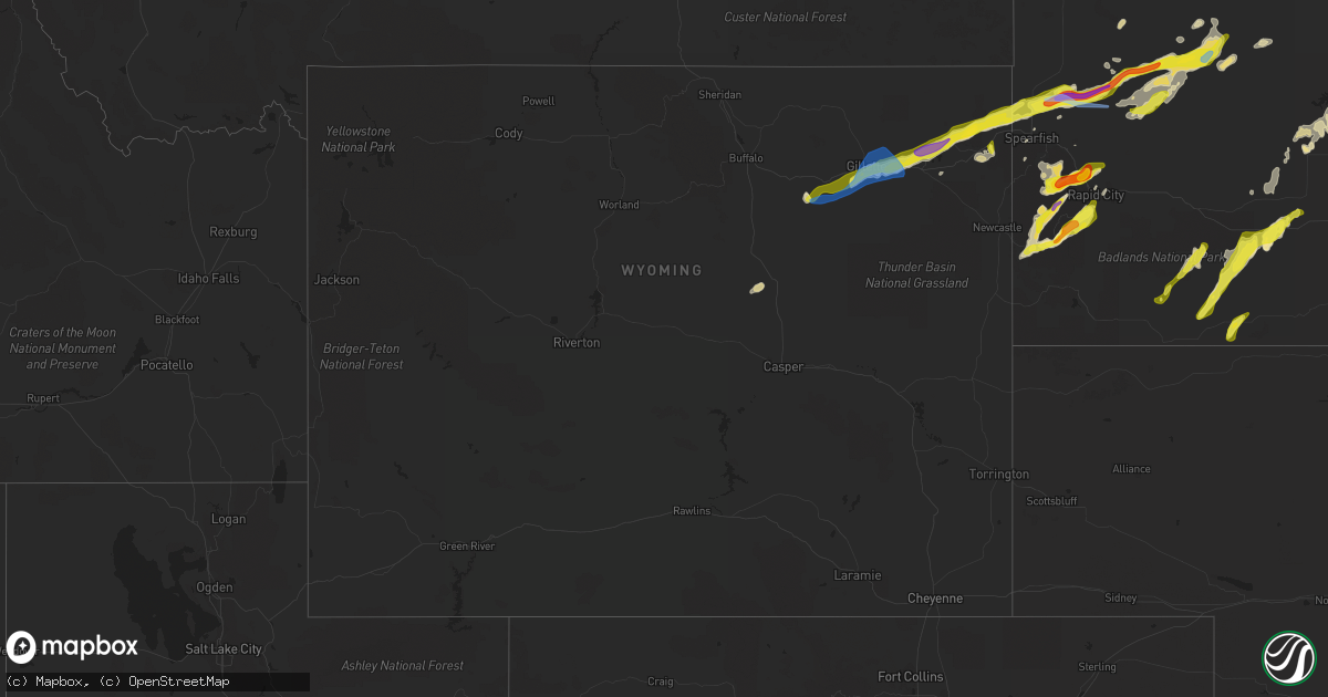
Hail Map in Wyoming on June 28, 2020
Get this storm
June 28 map
$229
one time, instant access
Download today. No call, no setup
Keep the $229
Bought the map and want the full workflow? Apply the entire $229 to a subscription within 7 days. None of it is wasted.
Every map, not just this one
This buys you this map. Subscription and you get every map we run, in the markets you choose from a few cities to whole states to nationwide. Plus real-time alerts the moment a storm fires.
Contact data
Name, contact info, occupancy, even credit band for addresses in the footprint. You go from where it hit to who to call.
Become the source they trust
Unlimited branding weather history reports on demand. You already have the documented answer ready for the property owner, and you are the one who showed up with it.
Property data and RoofTrace estimates
Pull up any address you have got, its value and the exact code rules for that jurisdiction, straight from One Click Code. Then RoofTrace estimates the squares, pitch, and roof value, priced the way you price.
Storm reports in Wyoming
Wyoming
| Date | Description |
|---|---|
| 06/28/20206:32 PM CDT | Wydot station wy62 i25 us87 - smokey gap. |
| 06/28/20205:47 PM CDT | A local report indicates 60 MPH wind near 3 E SUNDANCE |
| 06/28/20205:32 PM CDT | A local report indicates 1.00 inch wind near ALADDIN |
| 06/28/20205:26 PM CDT | Mesonet station krec atlantic city 10 ne |
| 06/28/20205:05 PM CDT | A local report indicates 1.75 inch wind near 11 E DEVILS TOWER |
| 06/28/20205:00 PM CDT | A local report indicates 1.00 inch wind near 9 SE DEVILS TOWER |
| 06/28/20204:35 PM CDT | Awos station kemm kemmerer airport. |
| 06/28/20204:14 PM CDT | A power pole was broken off... Numerous houses lost siding... A roof was blown off one. |
| 06/28/20204:10 PM CDT | Camper laid on it's side |
| 06/28/20204:10 PM CDT | Camper laid on it's side |
| 06/28/20204:05 PM CDT | A local report indicates 1.00 inch wind near ROZET |
| 06/28/20203:50 PM CDT | A local report indicates 60 MPH wind near 5 ENE DWTN GILLETTE |
| 06/28/20203:50 PM CDT | A local report indicates 1.00 inch wind near 5 ENE DWTN GILLETTE |
| 06/28/20203:42 PM CDT | A local report indicates 1.00 inch wind near DWTN GILLETTE |
| 06/28/20203:40 PM CDT | A local report indicates 60 MPH wind near 1 S DWTN GILLETTE |
| 06/28/20203:35 PM CDT | A local report indicates 1.00 inch wind near 4 S DWTN GILLETTE |
| 06/28/20203:30 PM CDT | Lost roof off a barn... Debris thrown 150 feet |
| 06/28/20203:25 PM CDT | A local report indicates 70 MPH wind near 9 WSW DWTN GILLETTE |
| 06/28/20203:22 PM CDT | A local report indicates 61 MPH wind near 16 WSW DWTN GILLETTE |
| 06/28/20203:18 PM CDT | Asos station krks rock springs airport. |
| 06/28/20203:10 PM CDT | Roof blown away |
| 06/28/20202:41 PM CDT | Asos station krks rock springs airport. |
| 06/28/20202:20 PM CDT | Asos station kcpr casper airport. |
| 06/28/20202:32 AM CDT | At 732 PM MDT, a severe thunderstorm was located 17 miles north of Legend Rock State Petroglyph Site, which is 21 miles southeast of Meeteetse, moving northeast at 30 mph. HAZARD...60 mph wind gusts and penny size hail. SOURCE...Radar indicated. IMPACT...Expect damage to roofs, siding, and trees. This severe thunderstorm will remain over mainly rural areas of north central Hot Springs, southwestern Big Horn and northwestern Washakie Counties, including the following locations... Badlands Overlook. |
| 06/28/202012:01 AM CDT | At 501 PM MDT, a severe thunderstorm was located 12 miles west of Midwest, which is 19 miles south of Kaycee, moving northeast at 30 mph. HAZARD...60 mph wind gusts and penny size hail. SOURCE...Radar indicated. IMPACT...Expect damage to roofs, siding, and trees. This severe thunderstorm will be near... Midwest around 520 PM MDT. Linch around 540 PM MDT.Other locations impacted by this severe thunderstorm include Sussex.This includes Interstate 25 between mile markers 214 and 246. |
| 06/27/202011:46 PM CDT | At 446 PM MDT, a severe thunderstorm was located 5 miles east of Sundance, moving northeast at 35 mph. HAZARD...60 mph wind gusts and quarter size hail. SOURCE...Radar indicated. IMPACT...Hail damage to vehicles is expected. Expect wind damage to roofs, siding, and trees. This severe thunderstorm will be near... Cement Ridge Lookout around 500 PM MDT. Crow Peak around 510 PM MDT. Spearfish Canyon around 515 PM MDT. Spearfish around 525 PM MDT. Whitewood and Saint Onge around 535 PM MDT.This includes... Interstate 90 in South Dakota between Mile Markers 1 and 28. Interstate 90 in Wyoming between Mile Markers 186 and 196, and nearMile Marker 207. |
| 06/27/202011:38 PM CDT | At 436 PM MDT, severe thunderstorms were located along a line extending from 11 miles southeast of Hudson to 7 miles southeast of Sand Draw, moving northeast at 65 mph. HAZARD...60 mph wind gusts. SOURCE...Radar indicated. IMPACT...Expect damage to roofs, siding, and trees. Severe thunderstorms will be near... Sand Draw around 440 PM MDT. Boysen State Park and Hidden Valley around 500 PM MDT. Shoshoni around 510 PM MDT. Moneta around 515 PM MDT.Other locations impacted by these severe thunderstorms includeRiverton Landfill and Bonneville.This severe thunderstorm warning replaces the previous severe thunderstorm warning that covered South Pass. |
| 06/27/202011:35 PM CDT | At 434 PM MDT, a severe thunderstorm was located 7 miles southwest of Mayoworth, which is 11 miles west of Kaycee, moving northeast at 50 mph. HAZARD...60 mph wind gusts and penny size hail. SOURCE...Radar indicated. IMPACT...Expect damage to roofs, siding, and trees. This severe thunderstorm will be near... Mayoworth around 440 PM MDT. Kaycee around 445 PM MDT.Other locations impacted by this severe thunderstorm include Barnum.This includes the following highways... Interstate 25 between mile markers 246 and 277. Interstate 90 between mile markers 79 and 88. |
| 06/27/202011:05 PM CDT | At 404 PM MDT, a severe thunderstorm was located near South Pass City, which is 23 miles south of Lander, moving northeast at 55 mph. HAZARD...60 mph wind gusts. SOURCE...Radar indicated. IMPACT...Expect damage to roofs, siding, and trees. This severe thunderstorm will be near... Red Canyon around 415 PM MDT. Sand Draw around 440 PM MDT.Other locations impacted by this severe thunderstorm include AtlanticCity, Highway 28, and the Red Canyon area. |
| 06/27/20209:54 PM CDT | At 253 PM MDT, a severe thunderstorm was located near Rozet, or 11 miles east of Gillette, moving east at 40 mph. HAZARD...70 mph wind gusts and half dollar size hail. SOURCE...Radar indicated. This storm has a history of producing winds in excess of 70 mph and at least quarter size hail as reported by trained spotters. IMPACT...Hail damage to vehicles is expected. Expect considerable tree damage. Wind damage is also likely to mobile homes, roofs, and outbuildings. This severe thunderstorm will be near... Moorcroft around 315 PM MDT. Keyhole Reservoir around 320 PM MDT. Pine Haven around 325 PM MDT. Carlile around 330 PM MDT. Devils Tower Junction around 340 PM MDT.This includes Interstate 90 in Wyoming between Mile Markers 134 and183. |
| 06/27/20209:16 PM CDT | At 216 PM MDT, severe thunderstorms were located along a line extending from 7 miles west of Pumpkin Buttes to 4 miles southwest of Pine Tree Junction, moving northeast at 35 mph. HAZARD...60 mph wind gusts and quarter size hail. SOURCE...Radar indicated. IMPACT...Hail damage to vehicles is expected. Expect wind damage to roofs, siding, and trees. Severe thunderstorms will be near... Pine Tree Junction and Pumpkin Buttes around 225 PM MDT. Savageton around 245 PM MDT. Wright around 250 PM MDT. Reno Junction around 255 PM MDT. |
| 06/27/20208:56 PM CDT | At 156 PM MDT, a severe thunderstorm was located 12 miles southeast of Powder River Rest Area, or 29 miles southwest of Gillette, moving northeast at 45 mph. HAZARD...60 mph wind gusts and quarter size hail. SOURCE...Radar indicated. IMPACT...Hail damage to vehicles is expected. Expect wind damage to roofs, siding, and trees. This severe thunderstorm will be near... Gillette and Gillette Airport around 235 PM MDT. Camplex Event Facility around 240 PM MDT.This includes Interstate 90 in Wyoming between Mile Markers 97 and137. |
| 06/27/20208:39 PM CDT | At 138 PM MDT, a severe thunderstorm was located near Antelope Hills, which is 20 miles north of Casper, moving northeast at 35 mph. HAZARD...60 mph wind gusts. SOURCE...Radar indicated. IMPACT...Expect damage to roofs, siding, and trees. This severe thunderstorm will remain over mainly rural areas of northeastern Natrona and southeastern Johnson Counties, including the following locations... Casper-Natrona County International Airport.This includes Interstate 25 between mile markers 195 and 229. |
All States Impacted by Hail Map on June 28, 2020
Cities Impacted by Hail Map on June 28, 2020
- Carpio, ND
- Lansford, ND
- Millington, MD
- Chestertown, MD
- Worton, MD
- Still Pond, MD
- Sudlersville, MD
- Crumpton, MD
- Kennedyville, MD
- Mandan, ND
- Napoleon, ND
- Hill City, SD
- Granville, ND
- Surrey, ND
- Norwich, ND
- Casper, WY
- West Haven, CT
- Orange, CT
- Shelton, CT
- Milford, CT
- Stratford, CT
- Mud Butte, SD
- Alfred, ME
- Glenwood City, WI
- Lake Crystal, MN
- Courtland, MN
- Midland, SD
- Wilton, ND
- Scenic, SD
- Kyle, SD
- Wharton, NJ
- Lake Hopatcong, NJ
- Clayton, AL
- Louisville, AL
- Montvale, NJ
- Westwood, NJ
- Orangeburg, NY
- Tappan, NY
- Pearl River, NY
- Moorcroft, WY
- Aladdin, WY
- Sundance, WY
- Belle Fourche, SD
- Beulah, WY
- Rozet, WY
- Gillette, WY
- Coleharbor, ND
- Riverdale, ND
- Garrison, ND
- Saint Paul, MN
- Montgomery, MN
- New Prague, MN
- Baldwin, ND
- Bismarck, ND
- Moscow, PA
- Gouldsboro, PA
- Lake Ariel, PA
- Custer, SD
- Keystone, SD
- Rapid City, SD
- Allen, SD
- Center, ND
- Newell, SD
- Buffalo, SD
- Lodgepole, SD
- Ralph, SD
- Ludlow, SD
- Reva, SD
- Stockholm, NJ
- Branchville, NJ
- Highland Lakes, NJ
- Glenwood, NJ
- Augusta, NJ
- Lafayette, NJ
- Vernon, NJ
- Franklin, NJ
- Hamburg, NJ
- Sussex, NJ
- Solen, ND
- Flasher, ND
- Denville, NJ
- Randolph, NJ
- Morris Plains, NJ
- Deadwood, SD
- Black Hawk, SD
- Nemo, SD
- Piedmont, SD
- Layton, NJ
- Adairville, KY
- Lead, SD
- Sturgis, SD
- Phoenicia, NY
- Dupree, SD
- Nisland, SD
- Faith, SD
- Meadow, SD
- Pierre, SD
- Saint Ansgar, IA
- Lyle, MN
- Fullerton, ND
- Lamoure, ND
- Downing, WI
- Clear Lake, WI
- Porcupine, SD
- Interior, SD
- Kadoka, SD
- Wanblee, SD
- Pine Ridge, SD
- Thompson, PA
- Olivia, MN
- Bird Island, MN
- Medway, MA
- Bellingham, MA
- Franklin, MA
- Kintyre, ND
- Philip, SD
- Pembroke, KY
- Hopkinsville, KY
- Wakpala, SD
- Millis, MA
- Milford, MA
- Cannon Falls, MN
- Dennison, MN
- Hampton, MN
- Farmington, MN
- Welch, MN
- Northfield, MN
- Hastings, MN
- Randolph, MN
- Sparrow Bush, NY
- Milford, PA
- Port Jervis, NY
- Huguenot, NY
- Montague, NJ
- Matamoras, PA
- Southfields, NY
- Pomona, NY
- Stony Point, NY
- Kaycee, WY
- Washburn, ND
- Martin, SD
- New Salem, ND
- Stewartville, MN
- Racine, MN
- Spring Valley, MN
- Grand Meadow, MN
- Parsippany, NJ
- Verona, ND
- Inver Grove Heights, MN
- Mcminnville, TN
- McKenzie, AL
- Evergreen, AL
- Georgiana, AL
- Fort Yates, ND
- Saint Anthony, ND
- Union Center, SD
- Forbes, ND
- Chatfield, MN
- Union, NH
- Deering, ND
- Minot, ND
- Upham, ND
- Velva, ND
- Bantry, ND
- Jermyn, PA
- Archbald, PA
- Carbondale, PA
- River Falls, WI
- Ellsworth, WI
- Bay City, WI
- Beldenville, WI
- Hager City, WI
- Elmwood, WI
- Maiden Rock, WI
- Spring Valley, WI
- Monson, MA
- Wales, MA
- Stafford Springs, CT
- Appleton, MN
- Opp, AL
- Winthrop, MN
- Gibbon, MN
- Steele, ND
- Berthold, ND
- Burlington, ND
- Buffalo, ND
- Scituate, MA
- Ocklawaha, FL
- Silver Springs, FL
- Fort McCoy, FL
- Long Eddy, NY
- Hancock, NY
- Fort Pierre, SD
- Seville, FL
- Pierson, FL
- Selfridge, ND
- Stanton, ND
- Cannon Ball, ND
- Shields, ND
- Danvers, MN
- Spring Valley, NY
- Suffern, NY
- Monsey, NY
- Maxbass, ND
- Park Ridge, NJ
- Sparkill, NY
- Piermont, NY
- Northvale, NJ
- Blauvelt, NY
- Nanuet, NY
- Nyack, NY
- Butler, AL
- Devils Tower, WY
- Easthampton, MA
- Northampton, MA
- Southampton, MA
- South Hadley, MA
- Hadley, MA
- Holyoke, MA
- Huntington, MA
- Florence, MA
- Rochester, MN
- Oronoco, MN
- Alzada, MT
- Trenton, KY
- Oshkosh, NE
- Dalton, MN
- Webster, MN
- Lonsdale, MN
- Savage, MN
- Rock Island, TN
- Holland, MA
- Hampden, MA
- Cerulean, KY
- McLaughlin, SD
- Northwood, IA
- Elkton, MN
- Adams, MN
- Kensett, IA
- Dexter, MN
- Rose Creek, MN
- Austin, MN
- Menomonie, WI
- Boyceville, WI
- Knapp, WI
- Gaylord, MN
- New Ulm, MN
- Nicollet, MN
- Saint Peter, MN
- Hanska, MN
- Madelia, MN
- Lafayette, MN
- Alton, NH
- Wolfeboro, NH
- Edgemont, SD
- Hermosa, SD
- Hazelton, ND
- Mendham, NJ
- Chester, NJ
- Hayes, SD
- Whitinsville, MA
- Sutton, MA
- Uxbridge, MA
- Harrisville, RI
- Long Valley, SD
- Johnston, SC
- Kilkenny, MN
- Faribault, MN
- Warsaw, MN
- Morristown, MN
- Waterville, MN
- North Smithfield, RI
- Aberdeen, SD
- Eagle Butte, SD
- Minneapolis, MN
- Burnsville, MN
- Lincoln, RI
- Smithfield, RI
- Granby, MA
- Chicopee, MA
- Glenburn, ND
- Brockton, MA
- Afton, MN
- Midway, AL
- Elkton, KY
- Oak Grove, KY
- Boyes, MT
- Hammond, MT
- Leola, SD
- Cohasset, MA
- Ludlow, MA
- Robinson, ND
- Caldwell, NJ
- Pine Brook, NJ
- Mountain Lakes, NJ
- Dover, NJ
- Whippany, NJ
- Lake Hiawatha, NJ
- Fairfield, NJ
- Montville, NJ
- Roseland, NJ
- Mount Tabor, NJ
- Rockaway, NJ
- East Hanover, NJ
- Shakopee, MN
- Prior Lake, MN
- Hobart, NY
- South Kortright, NY
- Guthrie, KY
- Mapleville, RI
- Putnam, CT
- Chepachet, RI
- Thompson, CT
- Pascoag, RI
- Oakland, RI
- Cologne, MN
- Carver, MN
- Chaska, MN
- Jordan, MN
- Prompton, PA
- Waymart, PA
- Gaffney, SC
- West Springfield, MA
- Ellendale, ND
- Waseca, MN
- Franklin, MN
- Chestnut Hill, MA
- Roxbury, MA
- Brookline, MA
- Jamaica Plain, MA
- Driscoll, ND
- Braddock, ND
- Medford, WI
- Roebuck, SC
- Spartanburg, SC
- Oakes, ND
- Lewiston, MN
- Winona, MN
- Walpole, MA
- Dover, MA
- Norwood, MA
- Sharon, MA
- Westwood, MA
- Canton, MA
- East Walpole, MA
- Blackstone, MA
- Southbridge, MA
- Letohatchee, AL
- Linton, ND
- Acton, ME
- East Wakefield, NH
- Enderlin, ND
- Belvidere, SD
- Sherborn, MA
- Morris, MN
- Donnelly, MN
- Fort Deposit, AL
- Joice, IA
- Pleasant Mount, PA
- Hector, MN
- Ashby, NE
- Nichols, SC
- Avon, MA
- Lapine, AL
- Hudson, WI
- Mankato, MN
- Cleveland, MN
- Le Center, MN
- Le Sueur, MN
- Madison Lake, MN
- Kasota, MN
- Minot Afb, ND
- Des Lacs, ND
- Newburg, ND
- Nome, ND
- Fingal, ND
- Mendota, MN
- Lakeville, MN
- Elko New Market, MN
- Hopkinton, MA
- Ashland, MA
- Upton, MA
- Scranton, PA
- Agar, SD
- Rib Lake, WI
- Holliston, MA
- Eddyville, IL
- Stirum, ND
- Deer Park, WI
- Spearfish, SD
- Charlotte, NC
- Hecla, SD
- Ware, MA
- Three Rivers, MA
- Palmer, MA
- Belchertown, MA
- Wilbraham, MA
- Bondsville, MA
- Wishek, ND
- Gurley, NE
- Florien, LA
- Graceville, MN
- Dorchester, MA
- Brighton, MA
- Hull, MA
- Roslindale, MA
- Quincy, MA
- Dorchester Center, MA
- Newton Center, MA
- Roxbury Crossing, MA
- Boston, MA
- Ninety Six, SC
- Pepin, WI
- Trempealeau, WI
- Saint Charles, MN
- Galesville, WI
- Rollingstone, MN
- Eyota, MN
- Altura, MN
- Lake Mills, IA
- Dodge, WI
- Minnesota City, MN
- Hanlontown, IA
- Fountain City, WI
- Utica, MN
- Dover, MN
- Hammond, WI
- Wrentham, MA
- Norfolk, MA
- Abington, MA
- Whitman, MA
- Millville, MA
- Hopedale, MA
- Stoughton, MA
- Mendon, MA
- Woonsocket, RI
- Medfield, MA
- Northbridge, MA
- Plainville, MA
- Cumberland, RI
- Clara City, MN
- Raymond, MN
- Capitol, MT
- Woodville, WI
- Winthrop, MA
- Wing, AL
- Trail City, SD
- Stewart, MN
- Buffalo Lake, MN
- Janesville, MN
- Souris, ND
- Hoffman, MN
- Herman, MN
- Prescott, WI
- Baldwin, WI
- Red Wing, MN
- Roberts, WI
- Monroe, NY
- Marion, LA
- Washingtonville, NY
- Campbell Hall, NY
- Rock Tavern, NY
- Hingham, MA
- Norwell, MA
- Lancaster, SC
- Waxhaw, NC
- Glenham, SD
- Dawson, ND
- Houghton, SD
- Columbia, SD
- Katonah, NY
- Bedford Hills, NY
- Tompkinsville, KY
- Kenyon, MN
- Wanamingo, MN
- Andalusia, AL
- Murdock, MN
- Bastrop, LA
- Crossett, AR
- Bethany, CT
- Belle Plaine, MN
- Sanbornville, NH
- Shapleigh, ME
- West Newfield, ME
- South Walpole, MA
- East Bridgewater, MA
- Holbrook, MA
- Glendale, RI
- Mansfield, MA
- Norton, MA
- Randolph, MA
- West Bridgewater, MA
- North Easton, MA
- Douglas, MA
- South Easton, MA
- Foxboro, MA
- Greenville, AL
- Valley City, ND
- Leeds, NY
- Freehold, NY
- Cairo, NY
- Montclair, NJ
- Little Falls, NJ
- Cedar Grove, NJ
- Chichester, NY
- Castleberry, AL
- Belmont, NC
- Yulan, NY
- Eldred, NY
- Narrowsburg, NY
- Pond Eddy, NY
- Highland Lake, NY
- Glen Spey, NY
- Barryville, NY
- Suffield, CT
- Correll, MN
- Odessa, MN
- Ortonville, MN
- Bloomingburg, NY
- Circleville, NY
- Pine Bush, NY
- Montgomery, NY
- Middletown, NY
- Exline, IA
- Mendon, IL
- Fowler, IL
- Adolphus, KY
- Hancock, MN
- Mondovi, WI
- Alma, WI
- Eufaula, AL
- Hannaford, ND
- Big Springs, NE
- Moravia, IA
- Mobridge, SD
- Little Eagle, SD
- Gilbertville, MA
- New Braintree, MA
- Millbury, MA
- Roxbury, NY
- Honoraville, AL
- Blenheim, SC
- Bennettsville, SC
- Woodstock, CT
- Westmoreland, TN
- Dedham, MA
- Hyde Park, MA
- Milton, MA
- Byron, MN
- Pine Island, MN
- Kellogg, MN
- Millville, MN
- Plainview, MN
- Elgin, MN
- Pikeville, TN
- Bangor, PA
- Rosemount, MN
- Banks, AL
- Rogers, MN
- Greenwich, CT
- Port Chester, NY
- Camp Crook, SD
- Union Springs, AL
- Box Elder, SD
- Selby, SD
- Gettysburg, SD
- Cuddebackville, NY
- Otisville, NY
- Westbrookville, NY
- Princeton, KY
- Dawson Springs, KY
- Cottage Grove, MN
- Saint Paul Park, MN
- Newport, MN
- Amherst, NH
- Milford, NH
- Malden, MA
- Everett, MA
- Haydenville, MA
- Stillwater, MN
- Shandaken, NY
- Tracy, IA
- Knoxville, IA
- Crofton, KY
- Dazey, ND
- Marine On Saint Croix, MN
- Florida, NY
- Goshen, NY
- Warwick, NY
- Chester, NY
- Williamsburg, MA
- Pollock, SD
- Belgrade, MN
- Fiskdale, MA
- Lodgepole, NE
- Julesburg, CO
- Frederick, SD
- West Brookfield, MA
- Warren, MA
- Forest Hill, MD
- Fort Mill, SC
- Tappen, ND
- Lumpkin, GA
- Morris, GA
- Seale, AL
- Pittsview, AL
- Onida, SD
- Dundas, MN
- Kearny, NJ
- Newark, NJ
- Blomkest, MN
- Danube, MN
- Page, ND
- Ramer, AL
- Grady, AL
- Springfield, MA
- Jessup, PA
- Olyphant, PA
- Claremont, SD
- North Hatfield, MA
- West Hatfield, MA
- Sunderland, MA
- Hatfield, MA
- Leverett, MA
- South Deerfield, MA
- Shutesbury, MA
- Amherst, MA
- Ooltewah, TN
- Jonesville, SC
- Montevideo, MN
- Maynard, MN
- Scottsville, KY
- Callicoon, NY
- Damascus, PA
- Topeka, KS
- Maple Hill, KS
- Harveyville, KS
- Mountain Lake, MN
- Prinsburg, MN
- Millry, AL
- Frankville, AL
- Middlebury, CT
- Woodbury, CT
- Benson, MN
- Barrett, MN
- Dale, TX
- Westtown, NY
- Amherst, SD
- Boonton, NJ
- Lincoln Park, NJ
- Butler, NJ
- Towaco, NJ
- Far Rockaway, NY
- Arverne, NY
- Cogswell, ND
- Saluda, SC
- Chappells, SC
- Arthur, NE
- Mound City, SD
- Colchester, CT
- West Newton, MA
- Auburndale, MA
- Newtonville, MA
- Waltham, MA
- Waban, MA
- Palisades, NY
- Irvington, NY
- Downing, MO
- Arkville, NY
- Big Indian, NY
- Amery, WI
- West Concord, MN
- Colfax, WI
- Lakeland, MN
- Wabasha, MN
- Woodstock Valley, CT
- Westborough, MA
- Fredonia, ND
- Kulm, ND
- Prairie City, SD
- Hoven, SD
- Milton, NH
- Milton Mills, NH
- Chidester, AR
- North Grafton, MA
- Shrewsbury, MA
- Oxford, MA
- Glen Gardner, NJ
- New Richmond, WI
- Fitzpatrick, AL
- Oriska, ND
- Westboro, WI
- Nerstrand, MN
- Cyrus, MN
- Elmsford, NY
- West Nyack, NY
- Tarrytown, NY
- White Plains, NY
- Dobbs Ferry, NY
- Ardsley, NY
- Hartsdale, NY
- Britton, SD
- Glenwood, MO
- Queen City, MO
- Sudbury, MA
- Weston, MA
- Wayland, MA
- Chattanooga, TN
- Medford, MN
- Owatonna, MN
- Carlisle, SC
- Buffalo, SC
- Union, SC
- Batesburg, SC
- Leesville, SC
- Mullins, SC
- Florence, SC
- Sellers, SC
- Darlington, SC
- Marion, SC
- Green Sea, SC
- Tabor City, NC
- Nakina, NC
- Loris, SC
- Derby, CT
- Woodbridge, CT
- Bridgton, ME
- Sebago, ME
- Naples, ME
- Denmark, ME
- Hiram, ME
- Fishs Eddy, NY
- Salisbury Mills, NY
- Maybrook, NY
- New Windsor, NY
- Cornwall, NY
- Prattsville, NY
- Harriman, NY
- Lanesville, NY
- New City, NY
- Allensville, KY
- Ekalaka, MT
- Batesland, SD
- Highland Home, AL
- Montgomery, AL
- Richland, GA
- Preston, GA
- Lewellen, NE
- Mohall, ND


