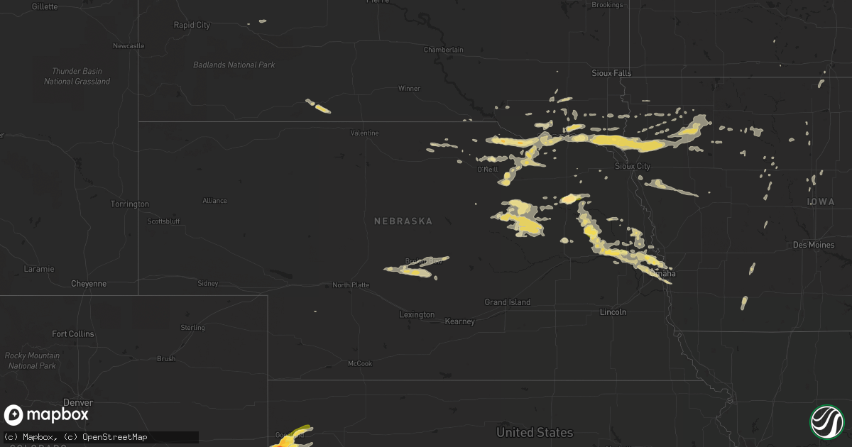
Hail Map in Nebraska on June 28, 2014
Get this storm
June 28 map
$229
one time, instant access
Download today. No call, no setup
Keep the $229
Bought the map and want the full workflow? Apply the entire $229 to a subscription within 7 days. None of it is wasted.
Every map, not just this one
This buys you this map. Subscription and you get every map we run, in the markets you choose from a few cities to whole states to nationwide. Plus real-time alerts the moment a storm fires.
Contact data
Name, contact info, occupancy, even credit band for addresses in the footprint. You go from where it hit to who to call.
Become the source they trust
Unlimited branding weather history reports on demand. You already have the documented answer ready for the property owner, and you are the one who showed up with it.
Property data and RoofTrace estimates
Pull up any address you have got, its value and the exact code rules for that jurisdiction, straight from One Click Code. Then RoofTrace estimates the squares, pitch, and roof value, priced the way you price.
Storm reports in Nebraska
Nebraska
| Date | Description |
|---|---|
| 06/28/20146:45 PM CDT | A local report indicates 1.75 inch wind near 2 NE HADAR |
| 06/28/20146:30 AM CDT | Hail covered the ground. |
| 06/28/20146:30 AM CDT | A local report indicates 60 MPH wind near 7 E CALLAWAY |
| 06/28/20143:44 AM CDT | A local report indicates 1.00 inch wind near SANTEE |
| 06/27/201410:42 PM CDT | A local report indicates 1.00 inch wind near 3 E BENNINGTON |
| 06/27/20149:06 PM CDT | Also 45-55 mph winds and 0.40 of rainfall. |
| 06/27/20148:07 PM CDT | A local report indicates 1.00 inch wind near HOWELLS |
| 06/27/20147:50 PM CDT | A local report indicates 1.00 inch wind near CLARKSON |
All States Impacted by Hail Map on June 28, 2014
Cities Impacted by Hail Map on June 28, 2014
- Winnsboro, LA
- Broken Bow, NE
- Callaway, NE
- Goodland, KS
- Ewing, NE
- Buffalo, OK
- Bridger, MT
- Chiefland, FL
- Bellevue, NE
- Council Bluffs, IA
- Springfield, SD
- Niobrara, NE
- Lynch, NE
- Verdigre, NE
- Tuthill, SD
- Saint Francis, SD
- Stuart, NE
- Atkinson, NE
- Wewahitchka, FL
- Winona, KS
- Wallace, KS
- Cedar Lake, IN
- Alford, FL
- Dunnellon, FL
- Humboldt, IA
- Fort Dodge, IA
- Brinkley, AR
- Cotton Plant, AR
- Beebe, AR
- Ottosen, IA
- Rolfe, IA
- Yankton, SD
- Tilden, NE
- Battle Creek, NE
- Meadow Grove, NE
- Sarasota, FL
- Richton, MS
- Columbia, MS
- Oklahoma City, OK
- Edmond, OK
- Sanborn, IA
- Primghar, IA
- Archer, IA
- Larrabee, IA
- Meriden, IA
- Cleghorn, IA
- Cherokee, IA
- Paullina, IA
- Peterson, IA
- Sutherland, IA
- Howells, NE
- Fremont, NE
- Scribner, NE
- Clarkson, NE
- Crescent, IA
- Wisner, NE
- Bennington, NE
- North Bend, NE
- Hoskins, NE
- Hooper, NE
- Boys Town, NE
- Schuyler, NE
- Stanton, NE
- Pilger, NE
- Cedar Bluffs, NE
- Kennard, NE
- Dodge, NE
- Arlington, NE
- Ames, NE
- Elkhorn, NE
- Rogers, NE
- Omaha, NE
- Blair, NE
- Nickerson, NE
- Fort Calhoun, NE
- Valley, NE
- Marion, AL
- Utica, KS
- Ransom, KS
- Mills, NE
- Grinnell, KS
- Gove, KS
- Quinter, KS
- Craig, NE
- Herman, NE
- Tekamah, NE
- Punta Gorda, FL
- Goldfield, IA
- Renwick, IA
- Burlington, CO
- Clearwater, NE
- Oakdale, NE
- West Point, NE
- Albion, NE
- Meridian, MS
- Oakland, NE
- Depew, OK
- Drumright, OK
- Bristow, OK
- Osyka, MS
- Kentwood, LA
- Orland Park, IL
- Oak Forest, IL
- Tinley Park, IL
- Becker, MN
- Alton, IA
- Remsen, IA
- Marcus, IA
- Fayette, MS
- Corning, IA
- Prescott, IA
- Gravity, IA
- Lenox, IA
- Smithland, IA
- Mutual, OK
- Vermillion, SD
- Merrill, IA
- Hinton, IA
- Burbank, SD
- Elk Point, SD
- Akron, IA
- Kingsley, IA
- Le Mars, IA
- Westfield, IA
- State Line, MS
- Woodward, OK
- Kiron, IA
- Forest Lake, MN
- Norfolk, NE
- Pierce, NE
- Hoisington, KS
- Great Bend, KS
- Collyer, KS
- Wakeeney, KS
- Mount Olive, MS
- York, AL
- Cuba, AL
- Petersburg, NE
- Minneapolis, MN
- Parsons, KS
- Marvell, AR
- Westerville, NE
- Arcadia, NE
- Gothenburg, NE
- Ansley, NE
- Alva, OK
- Waynoka, OK
- Dacoma, OK
- Fontanelle, IA
- McCune, KS
- Grant Park, IL
- Beecher, IL
- Oneill, NE
- Center, NE
- Pawnee Rock, KS
- Larned, KS
- Albert, KS
- Otis, KS
- Bison, KS
- Olmitz, KS
- Springview, NE
- Bassett, NE
- Humphrey, NE
- Genoa, WI
- De Soto, WI
- Elgin, NE
- Newman Grove, NE
- Primrose, NE
- Bartlett, NE
- Freeman, SD
- Bassfield, MS
- Claflin, KS
- Dighton, KS
- Healy, KS
- Monument, KS
- Oakley, KS
- Mission Hill, SD
- Beresford, SD
- Alcester, SD
- West Monroe, LA
- West Bend, IA
- Longton, KS
- Sharon Springs, KS
- Kanorado, KS
- Mason City, NE
- Oconto, NE
- Independence, KS
- Elk City, KS
- Bagley, IA
- Jamaica, IA
- Yale, IA
- Wyoming, MN
- Andover, MN
- Freedom, OK
- Martin, SD
- Newport, NE
- England, AR
- Newellton, LA
- Bloomfield, NE
- Washington, NE
- Wakonda, SD
- Volin, SD
- Avon, SD
- Fort Supply, OK
- Wynot, NE
- Gayville, SD
- Saint Helena, NE
- Irene, SD
- Menno, SD
- Utica, SD
- Eads, TN
- Belmond, IA
- Port Charlotte, FL
- Louin, MS
- Allen, NE
- Wakefield, NE
- Emerson, NE
- Jefferson, IA
- Paton, IA
- Bristow, NE
- Laurens, IA
- Webb, IA
- Curlew, IA
- Davenport, OK
- Chandler, OK
- Crofton, NE
- Mallard, IA
- Naples, FL
- Edson, KS
- Weskan, KS
- Brewster, KS
- Creston, NE
- Columbus, NE
- Story City, IA
- Jewell, IA
- Fordyce, NE
- Ellsworth, IA
- Cape Coral, FL
- Linn Grove, IA
- Jackson, AL
- Enterprise, LA
- Harrisonburg, LA
- Columbia, LA
- Saint Paul, MN
- Brookhaven, MS
- Hawarden, IA
- Ireton, IA
- Blue Earth, MN
- Silas, AL
- Stuttgart, AR
- Creighton, NE
- Winnetoon, NE
- Ruleville, MS
- Minter City, MS
- Storm Lake, IA
- Albert City, IA
- Stroud, OK
- Vicksburg, MS
- Rush Center, KS
- Hugo, MN
- Tabor, SD
- Chunky, MS
- Sharon, OK
- Welch, OK
- Ward, AR
- Olla, LA
- Mapleton, IA
- Oto, IA
- Moville, IA
- Anthon, IA
- Hornick, IA
- Kanawha, IA
- Garner, IA
- Tyndall, SD
- McCracken, KS
- Sweet Water, AL
- Gould, AR
- Bay Minette, AL
- Vici, OK
- Wall, SD
- Charter Oak, IA
- Battle Creek, IA
- Denison, IA
- Danbury, IA
- Schleswig, IA
- Sloan, IA
- Salix, IA
- Hartley, IA
- Wagner, SD
- Buffalo, KS
- Benedict, KS
- Orange City, IA
- Maurice, IA
- Burwell, NE
- Sergeant Bluff, IA
- Orchard, NE
- Somers, IA
- Coleridge, NE
- Wallace, NE
- Northwood, IA
- Lake Mills, IA
- Joice, IA
- Mountain, WI
- Ridgeway, IA
- Colby, KS
- Almyra, AR
- Crocketts Bluff, AR
- Casscoe, AR
- Shuqualak, MS
- Deerwood, MN
- Scotland, SD
- Clutier, IA
- Jonesville, LA
- Aimwell, LA
- Momence, IL
- Emery, SD
- Bridgewater, SD
- Hull, IA
- Crenshaw, MS
- Gillett, AR
- De Witt, AR
- Pittsburg, KS
- Girard, KS
- Kellyville, OK
- Stacy, MN
- North Branch, MN
- Saint Paul, KS
- Midland, SD
- Moorland, IA
- Roxie, MS
- Fairfax, SD
- Spencer, NE
- Delhi, LA
- Searcy, AR
- Cherokee, KS
- Dunkerton, IA
- Waterloo, IA
- Tulsa, OK
- McRae, AR
- Lesterville, SD
- Olivet, SD
- Sioux Center, IA
- Sledge, MS
- Page, NE
- Bogue Chitto, MS
- Circle Pines, MN
- Paulding, MS
- Myakka City, FL
- Collinsville, MS
- Lowell, IN
- Crown Point, IN
- Carroll, NE
- Granville, IA
- La Porte City, IA
- Vilonia, AR
- El Paso, AR
- Waynesboro, MS
- Middleton, TN
- Mayer, MN
- Marion Junction, AL
- Centerville, SD
- Swatara, MN
- Brooksville, FL
- Collins, MS
- Clare, IA
- Hudson, SD
- Lyon, MS
- Clarksdale, MS
- Enid, MS
- Mount Hermon, LA
- Arcadia, OK
- Luther, OK
- Jones, OK
- La Crosse, KS
- Madison, NE
- Fonda, IA
- Pocahontas, IA
- Palmer, IA
- Miami, FL
- Trout, LA
- Leakesville, MS
- Marianna, FL
- Fountain, FL
- Spalding, NE
- Vona, CO
- Winside, NE
- Marks, MS
- Little Rock, AR
- Osage, OK
- Sheridan, AR
- Jefferson, AR
- Redfield, AR
- Hensley, AR
- Parrish, FL
- Brownell, KS
- Uniontown, AL
- Seiling, OK
- Humboldt, KS
- Quinn, SD
- Rembrandt, IA
- Lindstrom, MN
- Dennis, KS
- Amboy, MN
- Cherryvale, KS
- Lake Andes, SD
- De Kalb, MS
- Hominy, OK
- Taloga, OK
- Vredenburgh, AL
- Bonesteel, SD
- Frankville, AL
- Twin Lakes, MN
- Hospers, IA
- Alden, IA
- Radcliffe, IA
- Williams, IA
- Lorman, MS
- Port Gibson, MS
- Alma, WI
- Boligee, AL
- Koshkonong, MO
- Chicago, IL
- Starkville, MS
- Mississippi State, MS
- Holly Grove, AR
- Ovett, MS
- Gowrie, IA
- Viroqua, WI
- Clarion, IA
- Havelock, IA
- Sioux Rapids, IA
- Newcastle, NE
- Calumet, IA
- Royal, IA
- Inman, NE
- Aurelia, IA
- Young America, MN
- Norwood Young America, MN
- Almena, WI
- Bay Springs, MS
- Osprey, FL
- Callender, IA
- Scott, AR
- Canton, MS
- Alta, IA
- River Falls, WI
- Scandia, MN
- Chisago City, MN
- Mound Valley, KS
- Altamont, KS
- Marshalltown, IA
- Gilman, IA
- Arnett, OK
- Elberon, IA
- Wayne, NE
- Senatobia, MS
- Coldwater, MS
- Pickens, MS
- Camden, MS
- Ames, IA
- Mooreland, OK
- Randolph, NE


