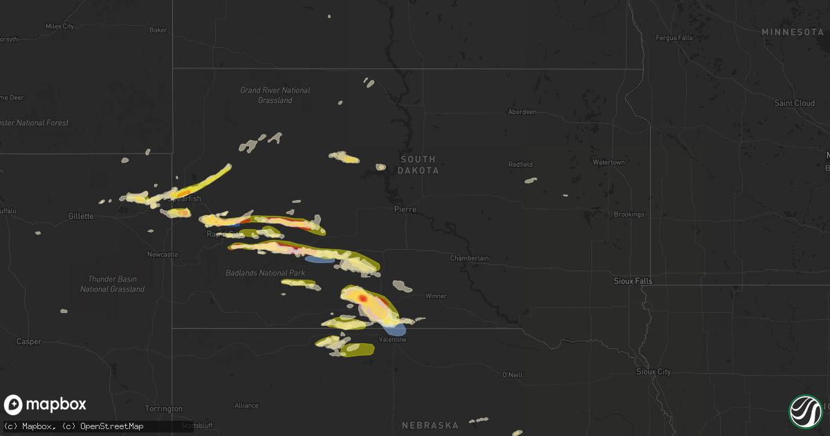
Hail Map in South Dakota on June 27, 2023
Get this storm
June 27 map
$229
one time, instant access
Download today. No call, no setup
Keep the $229
Bought the map and want the full workflow? Apply the entire $229 to a subscription within 7 days. None of it is wasted.
Every map, not just this one
This buys you this map. Subscription and you get every map we run, in the markets you choose from a few cities to whole states to nationwide. Plus real-time alerts the moment a storm fires.
Contact data
Name, contact info, occupancy, even credit band for addresses in the footprint. You go from where it hit to who to call.
Become the source they trust
Unlimited branding weather history reports on demand. You already have the documented answer ready for the property owner, and you are the one who showed up with it.
Property data and RoofTrace estimates
Pull up any address you have got, its value and the exact code rules for that jurisdiction, straight from One Click Code. Then RoofTrace estimates the squares, pitch, and roof value, priced the way you price.
Storm reports in South Dakota
South Dakota
| Date | Description |
|---|---|
| 06/27/20236:25 PM CDT | A local report indicates 69 MPH wind near 7 NNE Ellsworth AFB |
| 06/27/20236:25 PM CDT | A local report indicates 1.00 inch wind near 7 NNE Ellsworth AFB |
| 06/27/20236:15 PM CDT | A local report indicates 75 MPH wind near 5 NW Ellsworth AFB |
| 06/27/20236:15 PM CDT | A local report indicates 75 MPH wind near 5 NW Ellsworth AFB |
| 06/27/20236:15 PM CDT | A local report indicates 1.75 inch wind near 5 NW Ellsworth AFB |
| 06/27/20236:15 PM CDT | A local report indicates 1.75 inch wind near 10 N Scenic |
| 06/27/20236:09 PM CDT | A local report indicates 65 MPH wind near 6 NE Summerset |
| 06/27/20236:07 PM CDT | *** 1 inj *** meade county sheriff reports numerous homes and vehicles damaged just southeast of the elk creek road/haines ave intersection. |
| 06/27/20236:07 PM CDT | Meade county sheriff reports numerous homes and vehicles damaged just southeast of the elk creek road/haines ave intersection. No injuries or fatalities. |
| 06/27/20236:07 PM CDT | A local report indicates 1.00 inch wind near 6 NE Summerset |
| 06/27/20236:00 PM CDT | A local report indicates 60 MPH wind near 1 NNW Piedmont |
| 06/27/20236:00 PM CDT | Broken house windows |
| 06/27/20235:55 PM CDT | A local report indicates 65 MPH wind near Piedmont |
| 06/27/20235:55 PM CDT | Several trees damaged across the city of piedmont through the elk creek village subdivision one mile nnw of piedmont. |
| 06/27/20235:54 PM CDT | A local report indicates 60 MPH wind near 1 NNW Piedmont |
| 06/27/20235:34 PM CDT | A local report indicates 1.00 inch wind near New Underwood |
| 06/27/20235:26 PM CDT | A local report indicates 1.00 inch wind near Lead |
| 06/27/20235:18 PM CDT | A local report indicates 1.00 inch wind near 6 WSW Caputa |
| 06/27/20234:59 PM CDT | A local report indicates 1.00 inch wind near 3 W Dwtn Rapid City |
| 06/27/20234:00 PM CDT | A local report indicates 1.75 inch wind near Summerset |
| 06/27/20233:52 PM CDT | A local report indicates 1.25 inch wind near 1 NNW Piedmont |
| 06/27/20233:41 PM CDT | Marble hail with some quarters |
| 06/27/20232:51 PM CDT | Marble hail with a few quarters |
| 06/27/20232:30 PM CDT | A local report indicates 1.50 inch wind near 2 NW Dwtn Spearfish |
| 06/26/202310:20 PM CDT | A local report indicates 60 MPH wind near 23 SSE Okreek |
| 06/26/20239:57 PM CDT | A local report indicates 63 MPH wind near 15 SSE Mission |
| 06/26/20239:50 PM CDT | A local report indicates 60 MPH wind near 5 S Mission |
| 06/26/20239:50 PM CDT | A local report indicates 60 MPH wind near 4 SW Mission |
| 06/26/20239:47 PM CDT | A local report indicates 79 MPH wind near 15 SSE Mission |
| 06/26/20239:30 PM CDT | Tree branches down |
| 06/26/20239:00 PM CDT | Several buildings in the parmalee area have roof damage and broken windows. Many vehicles also received damage... Including broken windshields. |
| 06/26/20239:00 PM CDT | A local report indicates 2.50 inch wind near Parmelee |
| 06/26/20238:39 PM CDT | A local report indicates 1.25 inch wind near 5 ESE Norris |
| 06/26/20238:13 PM CDT | A local report indicates 1.00 inch wind near 4 N Philip |
| 06/26/20237:54 PM CDT | Mping report |
| 06/26/20237:39 PM CDT | Mping report |
| 06/26/20237:35 PM CDT | A local report indicates 1.25 inch wind near 4 S Creighton |
| 06/26/20237:30 PM CDT | A local report indicates 67 MPH wind near 4 E Cactus Flat |
| 06/26/20237:02 PM CDT | A local report indicates 1.00 inch wind near New Underwood |
All States Impacted by Hail Map on June 27, 2023
Cities Impacted by Hail Map on June 27, 2023
- Orlando, OK
- Mulhall, OK
- Edmond, OK
- Guthrie, OK
- Crescent, OK
- Wellston, OK
- Chandler, OK
- Jones, OK
- Sparks, OK
- Mcloud, OK
- Arcadia, OK
- Coyle, OK
- Carney, OK
- Perkins, OK
- Luther, OK
- Meridian, OK
- Prague, OK
- Meeker, OK
- Stillwater, OK
- Harrah, OK
- Tryon, OK
- Boley, OK
- Paden, OK
- Okemah, OK
- Davenport, OK
- Stroud, OK
- Jennings, OK
- Bristow, OK
- Agra, OK
- Yale, OK
- Castle, OK
- Cushing, OK
- Depew, OK
- Kellyville, OK
- Ripley, OK
- Drumright, OK
- Mannford, OK
- Glencoe, OK
- Inman, KS
- Moundridge, KS
- South Hutchinson, KS
- Hutchinson, KS
- Buhler, KS
- Burrton, KS
- Newton, KS
- Haven, KS
- Halstead, KS
- Hesston, KS
- Bentley, KS
- Mount Hope, KS
- Colwich, KS
- Sedgwick, KS
- Valley Center, KS
- Andale, KS
- Nickerson, KS
- Sterling, KS
- Wichita, KS
- Kechi, KS
- Maize, KS
- Sapulpa, OK
- Beggs, OK
- Mounds, OK
- Hanna, OK
- Weleetka, OK
- Okmulgee, OK
- Henryetta, OK
- Eufaula, OK
- Canadian, OK
- Checotah, OK
- Oktaha, OK
- Council Hill, OK
- Morris, OK
- Boynton, OK
- Stigler, OK
- Kinta, OK
- Whitefield, OK
- Porum, OK
- Quinton, OK
- Warner, OK
- Washington, AR
- Ozan, AR
- Badger, MN
- Alma, AR
- Lavaca, AR
- Nashville, AR
- Booneville, AR
- Waldron, AR
- Murfreesboro, AR
- Hope, AR
- Windom, KS
- Geneseo, KS
- Little River, KS
- Holtwood, PA
- Pequea, PA
- Muldrow, OK
- Lyons, KS
- Mcpherson, KS
- Marquette, KS
- Arkoma, OK
- Barling, AR
- Greenwood, AR
- Fort Smith, AR
- Midland, AR
- Mansfield, AR
- Hackett, AR
- Hartford, AR
- Cameron, OK
- Huntington, AR
- Conestoga, PA
- Poteau, OK
- Yukon, OK
- Pocola, OK
- Gurdon, AR
- Okolona, AR
- Columbus, AR
- Oklahoma City, OK
- Spencer, OK
- McCaskill, AR
- Covington, OK
- Odenton, MD
- Gambrills, MD
- Bowie, MD
- Millersville, MD
- Crofton, MD
- Spearfish, SD
- Belle Fourche, SD
- Saint Onge, SD
- Baltimore, MD
- Towson, MD
- Parkville, MD
- Nottingham, MD
- Davidsonville, MD
- Edgewater, MD
- Harwood, MD
- Nisland, SD
- Vale, SD
- Newell, SD
- Walsh, CO
- Nemo, SD
- Deadwood, SD
- Piedmont, SD
- Black Hawk, SD
- Rapid City, SD
- Sundance, WY
- Moorcroft, WY
- Lead, SD
- Caputa, SD
- Hermosa, SD
- Bridgeport, NE
- Bayard, NE
- Broadwater, NE
- Portland, AR
- Eudora, AR
- Hollandale, MS
- Greenville, MS
- Lake Village, AR
- Parkdale, AR
- Glen Allan, MS
- Chatham, MS
- Montrose, AR
- Lake Providence, LA
- Rolling Fork, MS
- Mayersville, MS
- Cary, MS
- Valley Park, MS
- Holly Bluff, MS
- Yazoo City, MS
- Redwood, MS
- Anguilla, MS
- Box Elder, SD
- New Underwood, SD
- Sturgis, SD
- Satartia, MS
- Bentonia, MS
- Vicksburg, MS
- Glen Saint Mary, FL
- Raiford, FL
- Wasta, SD
- Owanka, SD
- Wall, SD
- Lisco, NE
- Macclenny, FL
- Guymon, OK
- Hooker, OK
- Jacksonville, FL
- Osage, WY
- Upton, WY
- Northome, MN
- Blackduck, MN
- Lake City, FL
- Wellborn, FL
- Clayton, NM
- Hampton, AR
- Delhi, LA
- Live Oak, FL
- Lee, FL
- Shickshinny, PA
- Wapwallopen, PA
- Berwick, PA
- Virginia Beach, VA
- Middletown, DE
- Mud Butte, SD
- Annapolis, MD
- Junction City, AR
- El Dorado, AR
- Kenton, OK
- Meadow, SD
- Hamburg, AR
- Morehead City, NC
- Beaufort, NC
- Williams, MN
- Roosevelt, MN
- Boise City, OK
- Boyes, MT
- Atglen, PA
- Quarryville, PA
- Cochranville, PA
- Kirkwood, PA
- Christiana, PA
- Springfield, CO
- Two Buttes, CO
- Tallulah, LA
- Utica, MS
- Beulah, WY
- Devils Tower, WY
- Faith, SD
- Rozet, WY
- Brusett, MT
- Fort Peck, MT
- Westby, MT
- Warren, AR
- Alzada, MT
- Hulett, WY
- Oak Grove, LA
- Oakton, VA
- Herndon, VA
- Reston, VA
- Monticello, AR
- Harvey, AR
- Havelock, NC
- Jackson, AL
- Saint Stephens, AL
- Greenville, FL
- Hague, VA
- Forest Hill, MD
- Bel Air, MD
- Kaycee, WY
- Delta, PA
- Whiteford, MD
- Campo, CO
- McLean, VA
- Vienna, VA
- Great Falls, VA
- Stevensville, MD
- Salem, NJ
- Chesapeake, VA
- Thomasville, AL
- Townsend, DE
- Fallston, MD
- Baldwin, MD
- Fort George G Meade, MD
- Strong, AR
- Hammond, MT
- Hermitage, AR
- West River, MD
- Upper Marlboro, MD
- Crownsville, MD
- Galesville, MD
- Shady Side, MD
- Jonestown, PA
- Lebanon, PA
- Auburn, WY
- Phoenix, MD
- Lutherville Timonium, MD
- Hydes, MD
- Glen Arm, MD
- Street, MD
- Halethorpe, MD
- Brooklyn, MD
- Madison, FL
- Wolf Point, MT
- Mora, MN
- Isle, MN
- Halifax, PA
- Sheridan, AR
- Marion, LA
- Louann, AR
- Hot Springs Village, AR
- Crossett, AR
- Banks, AR
- Hot Springs National Park, AR
- Fredericksburg, PA
- Laurel, MD
- Jessup, MD
- Elkridge, MD
- Haynesville, LA
- Grenora, ND
- Frazer, MT
- Oshkosh, NE
- Holyoke, CO
- Wray, CO
- Champion, NE
- Goodwell, OK
- Gruver, TX
- Lewellen, NE
- Kadoka, SD
- Quinn, SD
- Turpin, OK
- Balko, OK
- Beaver, OK
- Hardesty, OK
- Hugoton, KS
- Rolla, KS
- Keyes, OK
- Texhoma, OK
- Liberal, KS
- Moscow, KS
- Satanta, KS
- Perryton, TX
- Forgan, OK
- Interior, SD
- Belvidere, SD
- Long Valley, SD
- Philip, SD
- Kyle, SD
- Wanblee, SD
- Plains, KS
- Meade, KS
- Spearman, TX
- Sunray, TX
- Stratford, TX
- Tyrone, OK
- Kismet, KS
- Copeland, KS
- Sublette, KS
- Fowler, KS
- Cimarron, KS
- Ensign, KS
- Montezuma, KS
- Gate, OK
- Englewood, KS
- Dodge City, KS
- Minneola, KS
- Lemoyne, NE
- Arthur, NE
- Sutherland, NE
- Tryon, NE
- Haigler, NE
- Parks, NE
- Lakota, ND
- Michigan, ND
- Petersburg, ND
- Fordville, ND
- Lankin, ND
- Sheyenne, ND
- Saint Michael, ND
- Oberon, ND
- Fort Totten, ND
- Ashland, KS
- Wright, KS
- Spearville, KS
- Ford, KS
- Bucklin, KS
- Protection, KS
- Mullinville, KS
- Rosston, OK
- Buffalo, OK
- Murdo, SD
- White River, SD
- Norris, SD
- Parmelee, SD
- Saint Francis, SD
- Martin, SD
- Tuthill, SD
- Merriman, NE
- Mission, SD
- Rosebud, SD
- Cody, NE
- Greensburg, KS
- Offerle, KS
- Freedom, OK
- Coldwater, KS
- Alva, OK
- Dahlen, ND
- Cando, ND
- Lake City, KS
- Kilgore, NE
- Baudette, MN
- Kiowa, KS
- Cherokee, OK
- Hardtner, KS
- Valentine, NE
- Nenzel, NE
- Crookston, NE
- Mooreland, OK
- Waynoka, OK
- Burlington, OK
- Amorita, OK
- Medicine Lodge, KS
- Hazelton, KS
- Manchester, OK
- Anthony, KS
- Attica, KS
- Danville, KS
- Harper, KS
- Waldron, KS
- Jet, OK
- Nash, OK
- Freeport, KS
- Wakita, OK
- Bluff City, KS
- Caldwell, KS
- Argonia, KS
- Medford, OK
- Milan, KS
- South Haven, KS
- Wellington, KS
- Mayfield, KS
- Braman, OK
- Oxford, KS
- Newkirk, OK
- Geuda Springs, KS
- Arkansas City, KS
- Kaw City, OK
- Ponca City, OK
- Udall, KS
- Winfield, KS
- Belle Plaine, KS
- Maple City, KS
- Leeds, ND
- Churchs Ferry, ND
- Rolla, ND
- Hansboro, ND
- Ismay, MT
- Carson, ND
- Dunn Center, ND
- Penn, ND
- Amite, LA
- Loranger, LA
- Husser, LA
- Waterproof, LA
- Ferriday, LA
- Clayton, LA
- Warsaw, VA
- Kinsale, VA
- Texline, TX
- Regan, ND
- Waynesboro, MS
- Pekin, ND
- Mchenry, ND
- Tolna, ND
- McLaughlin, SD
- Scenic, SD
- Dupree, SD
- Lantry, SD
- Eagle Butte, SD
- Lawtey, FL
- Sondheimer, LA
- Newellton, LA
- Dalhart, TX
- Grenville, NM
- Medora, ND
- Howes, SD
- Middleburg, FL
- Chatom, AL
- Manns Harbor, NC
- McIntosh, SD
- Roy, MT
- Elkhart, KS
- Ely, MN
- Transylvania, LA
- Yuma, CO
- Eckley, CO
- Babbitt, MN
- Perth, ND
- Columbia, NC
- Millry, AL
- Franklinton, LA
- Folsom, LA
- Princess Anne, MD
- State Line, MS
- Sidney, MT
- Raymond, MS
- Easton, MD
- Rayville, LA
- Imperial, NE
- Sedan, NM
- Sterlington, LA
- Silas, AL
- Saint Augustine, FL
- Killdeer, ND
- Wood, SD
- Green Cove Springs, FL
- Severna Park, MD
- Arnold, MD
- Porcupine, SD
- Bancroft, ID
- Sanderson, FL
- Jones, LA
- Starke, FL
- Saint Johns, FL
- Fleming Island, FL
- Orange Park, FL
- Westover, MD
- Madison, MS
- Canton, MS
- Lucedale, MS
- Pioneer, LA
- Knotts Island, NC
- Corolla, NC
- Beltsville, MD
- Fruitdale, AL
- Hattiesburg, MS
- Purvis, MS
- Preston, MD
- Glenfield, ND
- Milesville, SD
- Robertsdale, AL
- Burden, KS
- Dexter, KS
- Shidler, OK
- Burbank, OK
- Cambridge, KS
- Cedar Vale, KS
- Fairfax, OK
- Wynona, OK
- Pawhuska, OK
- Blackwell, OK
- Sedan, KS
- Chautauqua, KS
- Peru, KS
- Barnsdall, OK
- Bartlesville, OK
- Dewey, OK
- Copan, OK
- Ochelata, OK
- Golden Valley, ND
- Chelsea, OK
- Marland, OK
- Pocahontas, IA
- Palmer, IA
- Mcclusky, ND
- Hazen, ND
- Ericson, NE
- Big Cabin, OK
- Winner, SD
- Conway Springs, KS
- Delaware, OK
- Nowata, OK
- Red Rock, OK
- Burwell, NE
- Hominy, OK
- Scotia, NE
- Pawnee, OK
- Skiatook, OK
- Osage, OK
- Laverne, OK
- Glenrock, WY
- Springview, NE
- Mott, ND
- Iroquois, SD
- Hitchcock, SD
- Bartlett, NE
- Spalding, NE
- Greeley, NE
- Ralston, OK


