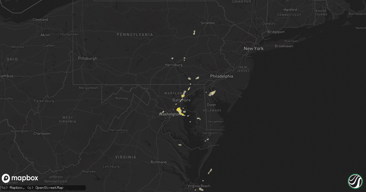
Hail Map on June 27, 2023
Get this storm
June 27 map
$229
one time, instant access
Download today. No call, no setup
Keep the $229
Bought the map and want the full workflow? Apply the entire $229 to a subscription within 7 days. None of it is wasted.
Every map, not just this one
This buys you this map. Subscription and you get every map we run, in the markets you choose from a few cities to whole states to nationwide. Plus real-time alerts the moment a storm fires.
Contact data
Name, contact info, occupancy, even credit band for addresses in the footprint. You go from where it hit to who to call.
Become the source they trust
Unlimited branding weather history reports on demand. You already have the documented answer ready for the property owner, and you are the one who showed up with it.
Property data and RoofTrace estimates
Pull up any address you have got, its value and the exact code rules for that jurisdiction, straight from One Click Code. Then RoofTrace estimates the squares, pitch, and roof value, priced the way you price.
States Impacted by Hail Map on June 27, 2023
Storm reports
Pennsylvania
| Date | Description |
|---|---|
| 06/27/20235:40 PM CDT | Northampton emergency management reports trees down throughout palmer township. Time estimated via radar. |
| 06/27/20235:01 PM CDT | Northampton emergency management reports trees and wires down throughout the area of bethlehem. |
| 06/27/20234:58 PM CDT | Report of a utility poll down on pa-132 between buck road and sycamore drive. |
| 06/27/20234:35 PM CDT | Downed tree in wires on church rd and pickering dam rd. Time estimated from radar. |
| 06/27/20233:50 PM CDT | Downed tree in wires on s main st. And main st. Time estimated from radar. |
| 06/27/20233:46 PM CDT | Power lines down on pa-132. Time estimated from radar. |
| 06/27/20233:46 PM CDT | Down power lines on pa-132. Time estimated from radar. |
| 06/27/20233:43 PM CDT | Corrects previous tstm wnd dmg report from 1 w lower southampton twp. Report of a utility poll down on pa-132 between buck road and sycamore drive. Corrected time to es |
| 06/27/20233:41 PM CDT | Downed utility pole on dreher ave/glen brook rd/cherry valley rd. Time estimated from radar. |
| 06/27/20233:38 PM CDT | Trees down throughout north and northeast philadelphia. Time estimated on radar. |
| 06/27/20233:04 PM CDT | Tree fell down on house causing structural damage. Radar time estimate. Via county dispatch. |
| 06/27/20233:04 PM CDT | Trees and wires down. Time estimated from radar. |
| 06/27/20232:53 PM CDT | Corrects previous tstm wnd dmg report from 2 ssw harveys lake. Trees and wires down. Time estimated from radar. |
| 06/27/20232:44 PM CDT | Trees down across roadway. Radar time estimate. Via county dispatch. |
| 06/27/20232:35 PM CDT | Corrects previous tstm wnd dmg report from 2 nnw devault. Downed tree in wires on church rd and pickering dam rd. Time estimated from radar. Corrected time. |
| 06/27/20232:20 PM CDT | Multiple downed trees near mountain drive. Time estimated by radar. |
| 06/27/20231:45 PM CDT | Reports of multiple trees and wires down along sand beach rd. Time estimated by radar. |
| 06/27/20231:40 PM CDT | Wires and tree down. Time estimated by radar. |
| 06/27/20231:25 PM CDT | Tree down on pa-041. Time estimated from radar. |
| 06/27/202312:13 PM CDT | Large tree knocked down along the intersection of martic heights dr & rawlinsville rd. Time estimated by radar. |
| 06/27/202312:06 PM CDT | Tree knocked down over power lines on douts hill rd. Time estimated by radar. |
| 06/26/20237:44 PM CDT | Road closed in both directions due to tree and wires down. Time estimated by radar. |
| 06/26/20237:44 PM CDT | Road closed in both directions due to tree and wires down. Time estimated by radar. |
Maryland
| Date | Description |
|---|---|
| 06/27/20234:39 PM CDT | Large tree down on glebe rd in easton. Time estimated from radar. |
| 06/27/20234:39 PM CDT | Large tree down on chapel rd. In easton. Time estimated from radar. |
| 06/27/20233:12 PM CDT | Quarter size hail was reported in middle river. |
| 06/27/20232:54 PM CDT | Quarter size hail was reported in birdsville. |
| 06/27/20232:40 PM CDT | A local report indicates 1.00 inch wind near 1 N Fullerton |
| 06/27/20232:31 PM CDT | Delayed report. Off-duty nws meteorologist reports quarter-sized hail in crofton. |
| 06/27/20232:25 PM CDT | Trees blew down blocking a couple of roadways in odenton. |
| 06/27/20232:15 PM CDT | Half dollar size hail was reported in the 2600 block of april dawn way in gambrills. |
| 06/27/20232:09 PM CDT | Quarter size hail was reported in piney orchard near odenton. |
| 06/27/20231:40 PM CDT | Trees blew down near street... Near the intersection of mill green road and md-646 prospect road... And along md-136 whiteford road. |
| 06/27/20231:01 PM CDT | A tree fell onto a gutter at a residence along kathleen drive in fallston. |
Texas
| Date | Description |
|---|---|
| 06/27/20235:54 PM CDT | A local report indicates 63 MPH wind near 4 WNW Stratford |
| 06/27/20235:13 PM CDT | Large tree was blown over on a house. Trained spotter collected a report from the resident of this home. Resident says no damage on the inside of the house. Time estima |
Oklahoma
| Date | Description |
|---|---|
| 06/27/20236:47 PM CDT | Photo submitted via social media. |
| 06/27/20236:46 PM CDT | Report from mping: grapefruit |
| 06/27/20236:31 PM CDT | Photo submitted via social media. |
| 06/27/20236:30 PM CDT | Report of downed telephone poles on the northside of hwy 56. |
| 06/27/20236:11 PM CDT | A local report indicates 1.75 inch wind near 6 SE Hough |
| 06/27/20236:11 PM CDT | Photo submitted via social media. |
| 06/27/202311:47 AM CDT | Power line down on hwy 9a / main street in arkoma. Radar estimated time. |
| 06/27/202310:15 AM CDT | A local report indicates 59 MPH wind near Checotah |
| 06/27/20239:09 AM CDT | A local report indicates 59 MPH wind near 4 SE Bristow |
| 06/27/20239:00 AM CDT | A local report indicates 60 MPH wind near Oilton |
| 06/27/20239:00 AM CDT | A local report indicates 60 MPH wind near Oilton |
| 06/27/20238:55 AM CDT | A local report indicates 66 MPH wind near 3 NE Chandler |
| 06/27/20238:30 AM CDT | Outbuilding roofs and trees damaged. |
| 06/27/20238:30 AM CDT | A local report indicates 79 MPH wind near 2 NNW Perkins |
| 06/27/20238:24 AM CDT | Reported by broken arrow em. |
| 06/27/20238:20 AM CDT | A local report indicates 60 MPH wind near 5 SSW Lake Carl Blackwe |
| 06/27/20237:55 AM CDT | A local report indicates 58 MPH wind near 3 SE Breckenridge |
| 06/26/202311:55 PM CDT | A local report indicates 63 MPH wind near 8 E Newkirk |
| 06/26/202310:00 PM CDT | Freedom mesonet. |
| 06/26/20239:50 PM CDT | May ranch mesonet. |
| 06/26/20238:05 PM CDT | Highest wind gust measured before data was lost for 15 minutes. |
| 06/26/20237:56 PM CDT | Trees down in forgan... Winds estimated to be around 80 mph. |
| 06/26/20237:47 PM CDT | Storm chaser measured with a mounted anemometer. |
| 06/26/20237:46 PM CDT | Irrigation pivot flipped just north of the highway. |
| 06/26/20237:37 PM CDT | Corrects previous tstm wnd dmg report from 6 e hardesty. Irrigation pivot flipped just north of the highway. Time was re-estimated on radar. |
| 06/26/20237:25 PM CDT | Report of barn roof sheared/blown off and downed power poles. |
| 06/26/20237:11 PM CDT | Report submitted via social media. Time estimated by radar. |
Utah
| Date | Description |
|---|---|
| 06/27/20236:20 PM CDT | A local report indicates 61 MPH wind near 7 SE SNOWVILLE |
| 06/27/20236:10 PM CDT | A local report indicates 62 MPH wind near 9 SSE SNOWVILLE |
North Carolina
| Date | Description |
|---|---|
| 06/27/20235:45 PM CDT | Dominion power reported numerous power outages between nags head and kill devil hills. |
Colorado
| Date | Description |
|---|---|
| 06/27/20236:25 PM CDT | Trained spotter reports hail from 0.75 up to quarter size. Time estimated from radar. |
| 06/27/20235:30 PM CDT | Public report of estimated thunderstorm wind gust of 60 mph. Time estimated from radar. |
| 06/27/20233:37 PM CDT | A local report indicates 1.00 inch wind near Walsh |
| 06/26/20237:05 PM CDT | Public report via social media of golf ball size hail 7 miles east of hwy 385 on cr 51. Time estimated from radar. |
| 06/26/20237:05 PM CDT | Public report via social media of broken power poles 7 miles east of hwy 385 on cr 51. Time estimated from radar. |
New Mexico
| Date | Description |
|---|---|
| 06/27/20235:34 PM CDT | Asos station krtn raton crews airport. |
| 06/27/20235:29 PM CDT | Asos station krtn raton crews airport. |
| 06/27/20233:55 PM CDT | Asos station ktcc tucumcari muni airport. |
| 06/27/20233:20 PM CDT | A local report indicates 64 MPH wind near 2 E Fort Sumner |
Florida
| Date | Description |
|---|---|
| 06/27/20236:53 PM CDT | Tree down over driveway in the vicinity of racetrack rd and veterans pkwy. |
| 06/27/20236:48 PM CDT | Trained storm spotter reported a large oak tree was uprooted and fell across fleming drive near the intersection of emilys way. |
| 06/27/20236:40 PM CDT | Tree and powerlines down across lake asbury drive west of circuit rider road causing partial roadway blockage. Time estimated by radar. |
| 06/27/20236:40 PM CDT | Delayed report with time estimated by radar. Large pine tree down on 160 block of johns street in clay county. |
| 06/27/20236:35 PM CDT | Delayed report. Large tree fell on home... Minor roof damage. Time estimated from radar. |
| 06/27/20236:35 PM CDT | Delayed report and time estimated from radar. Medium tree down and damage sustained to fence and pole barn. |
| 06/27/20236:35 PM CDT | Two large trees down across the southbound lane of henley road. One tree fell onto powerlines. Time estimated by radar. |
| 06/27/20236:35 PM CDT | Corrects previous storm report to include more detail on damage in lake asbury area. Delayed report and time estimated from radar. Medium tree down and damage sustained |
| 06/27/20236:35 PM CDT | Delayed report. Large tree fell on home... Minor roof damage. Time estimated from radar. |
| 06/27/20236:10 PM CDT | Report of power lines and trees down. |
| 06/27/20236:00 PM CDT | Multiple trees down. |
| 06/27/20235:58 PM CDT | Report of tree down over road and power outage. |
| 06/27/20235:50 PM CDT | Multiple trees down. |
| 06/27/20235:50 PM CDT | Trees and power lines down. |
| 06/27/20235:26 PM CDT | Tree and power line down caused by tstm winds. |
| 06/27/20235:18 PM CDT | Report of trees and power lines down caused by thunderstorms. |
| 06/27/20235:01 PM CDT | Power line and tree down caused by thunderstorm winds. |
| 06/27/20234:55 PM CDT | Corrects previous tstm wnd dmg report from 2 n live oak. Report of trees and power lines down caused by thunderstorms. |
| 06/26/20237:00 PM CDT | Report of multiple trees and power lines down caused by thunderstorm winds. |
| 06/26/20237:00 PM CDT | Trees down along state road 13 causing power outages around san juan del rio catholic church. Time estimated by radar. |
South Dakota
| Date | Description |
|---|---|
| 06/27/20236:25 PM CDT | A local report indicates 1.00 inch wind near 7 NNE Ellsworth AFB |
| 06/27/20236:25 PM CDT | A local report indicates 69 MPH wind near 7 NNE Ellsworth AFB |
| 06/27/20236:15 PM CDT | A local report indicates 1.75 inch wind near 10 N Scenic |
| 06/27/20236:15 PM CDT | A local report indicates 75 MPH wind near 5 NW Ellsworth AFB |
| 06/27/20236:15 PM CDT | A local report indicates 75 MPH wind near 5 NW Ellsworth AFB |
| 06/27/20236:15 PM CDT | A local report indicates 1.75 inch wind near 5 NW Ellsworth AFB |
| 06/27/20236:09 PM CDT | A local report indicates 65 MPH wind near 6 NE Summerset |
| 06/27/20236:07 PM CDT | A local report indicates 1.00 inch wind near 6 NE Summerset |
| 06/27/20236:07 PM CDT | Meade county sheriff reports numerous homes and vehicles damaged just southeast of the elk creek road/haines ave intersection. No injuries or fatalities. |
| 06/27/20236:07 PM CDT | *** 1 inj *** meade county sheriff reports numerous homes and vehicles damaged just southeast of the elk creek road/haines ave intersection. |
| 06/27/20236:00 PM CDT | A local report indicates 60 MPH wind near 1 NNW Piedmont |
| 06/27/20236:00 PM CDT | Broken house windows |
| 06/27/20235:55 PM CDT | Several trees damaged across the city of piedmont through the elk creek village subdivision one mile nnw of piedmont. |
| 06/27/20235:55 PM CDT | A local report indicates 65 MPH wind near Piedmont |
| 06/27/20235:54 PM CDT | A local report indicates 60 MPH wind near 1 NNW Piedmont |
| 06/27/20235:34 PM CDT | A local report indicates 1.00 inch wind near New Underwood |
| 06/27/20235:26 PM CDT | A local report indicates 1.00 inch wind near Lead |
| 06/27/20235:18 PM CDT | A local report indicates 1.00 inch wind near 6 WSW Caputa |
| 06/27/20234:59 PM CDT | A local report indicates 1.00 inch wind near 3 W Dwtn Rapid City |
| 06/27/20234:00 PM CDT | A local report indicates 1.75 inch wind near Summerset |
| 06/27/20233:52 PM CDT | A local report indicates 1.25 inch wind near 1 NNW Piedmont |
| 06/27/20233:41 PM CDT | Marble hail with some quarters |
| 06/27/20232:51 PM CDT | Marble hail with a few quarters |
| 06/27/20232:30 PM CDT | A local report indicates 1.50 inch wind near 2 NW Dwtn Spearfish |
| 06/26/202310:20 PM CDT | A local report indicates 60 MPH wind near 23 SSE Okreek |
| 06/26/20239:57 PM CDT | A local report indicates 63 MPH wind near 15 SSE Mission |
| 06/26/20239:50 PM CDT | A local report indicates 60 MPH wind near 4 SW Mission |
| 06/26/20239:50 PM CDT | A local report indicates 60 MPH wind near 5 S Mission |
| 06/26/20239:47 PM CDT | A local report indicates 79 MPH wind near 15 SSE Mission |
| 06/26/20239:30 PM CDT | Tree branches down |
| 06/26/20239:00 PM CDT | A local report indicates 2.50 inch wind near Parmelee |
| 06/26/20239:00 PM CDT | Several buildings in the parmalee area have roof damage and broken windows. Many vehicles also received damage... Including broken windshields. |
| 06/26/20238:39 PM CDT | A local report indicates 1.25 inch wind near 5 ESE Norris |
| 06/26/20238:13 PM CDT | A local report indicates 1.00 inch wind near 4 N Philip |
| 06/26/20237:54 PM CDT | Mping report |
| 06/26/20237:39 PM CDT | Mping report |
| 06/26/20237:35 PM CDT | A local report indicates 1.25 inch wind near 4 S Creighton |
| 06/26/20237:30 PM CDT | A local report indicates 67 MPH wind near 4 E Cactus Flat |
| 06/26/20237:02 PM CDT | A local report indicates 1.00 inch wind near New Underwood |
Kansas
| Date | Description |
|---|---|
| 06/27/20239:11 AM CDT | Nickel hail. |
| 06/27/20238:56 AM CDT | A local report indicates 70 MPH wind near Sedgwick |
| 06/27/20238:34 AM CDT | Tree branches of three to four inches in diameter were reported down via a picture on facebook. Time is based on wind report. |
| 06/27/20238:34 AM CDT | A local report indicates 80 MPH wind near Burrton |
| 06/27/20238:18 AM CDT | A local report indicates 64 MPH wind near Hutchinson Airport ASOS |
| 06/26/202311:38 PM CDT | At strother field. |
| 06/26/202310:55 PM CDT | 60-65mph. |
| 06/26/202310:40 PM CDT | Measured by kansas mesonet. |
| 06/26/202310:35 PM CDT | A local report indicates 60 MPH wind near 2 S Anthony |
| 06/26/202310:30 PM CDT | A local report indicates 60 MPH wind near 1.5 S Anthony |
| 06/26/202310:15 PM CDT | Emergency manager reported 60 mph gust in byers. Town is without power. |
| 06/26/20239:30 PM CDT | Tree limbs down... Wire down. Time est from radar. |
| 06/26/20239:30 PM CDT | Tree limbs down. Time est from radar. |
| 06/26/20239:30 PM CDT | Asos station kddc dodge city regional airport. |
| 06/26/20239:15 PM CDT | Mesonet station dw9907 bloom. |
| 06/26/20239:08 PM CDT | Asos station kddc dodge city regional airport. |
| 06/26/20239:00 PM CDT | Report of a semi blown over on highway 34 near mile marker 28. |
| 06/26/20239:00 PM CDT | Report received through social media. |
| 06/26/20239:00 PM CDT | Mesonet station dw9907 bloom. |
| 06/26/20238:59 PM CDT | Mesonet station up313 2.1 w minneola |
| 06/26/20238:55 PM CDT | Mesonet station gw3433 dodge city. |
| 06/26/20238:47 PM CDT | Mesonet station up835 3.0 w kingsdown |
| 06/26/20238:45 PM CDT | Mesonet station dw9907 bloom. |
| 06/26/20238:43 PM CDT | Multiple tree limbs down 3 inches and bigger. |
| 06/26/20238:39 PM CDT | Mesonet station up313 2.1 w minneola |
| 06/26/20238:34 PM CDT | Mesonet station up313 2.1 w minneola |
| 06/26/20238:32 PM CDT | Semi blown over on highway 400 at mile marker 130. |
| 06/26/20238:27 PM CDT | Mesonet station up367 4.9 ne meade |
| 06/26/20238:25 PM CDT | A local report indicates 100 MPH wind near 7 NE Missler |
| 06/26/20238:23 PM CDT | Wind speeds ranged from 60 to 70 mph. Meade is currently without power. |
| 06/26/20238:15 PM CDT | A local report indicates 70 MPH wind near 4 N Meade |
| 06/26/20238:05 PM CDT | Mesonet station ur350 4.4 ne hayne |
| 06/26/20237:20 PM CDT | A local report indicates 80 MPH wind near 8 SSE Feterita |
| 06/26/20237:12 PM CDT | A local report indicates 80 MPH wind near 9 S Hugoton |
Minnesota
| Date | Description |
|---|---|
| 06/27/20232:35 PM CDT | Public reports quarter sized hail. |
Nebraska
| Date | Description |
|---|---|
| 06/27/20236:55 PM CDT | A local report indicates 2.00 inch wind near Oshkosh |
| 06/27/20236:43 PM CDT | A local report indicates 2.50 inch wind near 10 W Oshkosh |
| 06/27/20236:32 PM CDT | A local report indicates 3.25 inch wind near Lisco |
| 06/27/20236:32 PM CDT | A local report indicates 2.75 inch wind near Lisco |
| 06/27/20236:31 PM CDT | Time estimated by radar. |
| 06/27/20236:29 PM CDT | Trained spotter reports hail of 2.5 inches in diameter. This corrects a previous public storm report. |
| 06/27/20236:29 PM CDT | Trained spotter reports hail of 3.5 inches in diameter |
| 06/27/20236:28 PM CDT | Social media report via twitter of between two to two and half inch diameter hail. |
| 06/27/20236:28 PM CDT | Trained spotter reports hail of 3 inches in diameter. |
| 06/27/20236:25 PM CDT | Trained spotter reports hail of 1.75 inches in diameter. |
| 06/27/20236:24 PM CDT | Trained spotter reports hail of two inches in diameter. |
| 06/27/20236:10 PM CDT | A local report indicates 1.00 inch wind near 10 SE Broadwater |
| 06/27/20235:30 PM CDT | Social media report of tennis ball sized hail stones. Damage to car windshield occurred. |
| 06/27/20235:28 PM CDT | Trained spotter reports hail size up to one inch in diameter. |
| 06/26/202310:19 PM CDT | A local report indicates 58 MPH wind near 1 S Valentine |
| 06/26/202310:19 PM CDT | (lbf |
| 06/26/20239:12 PM CDT | Pea to quarter sized hail. |
| 06/26/20238:30 PM CDT | A local report indicates 1.25 inch wind near 10 S Flats |
Idaho
| Date | Description |
|---|---|
| 06/27/20236:00 PM CDT | Itd rwis itd47 juniper interchange i-84. |
Virginia
| Date | Description |
|---|---|
| 06/27/20231:34 PM CDT | Trees blew down on va-7 leesburg pike near carlin springs road. |
| 06/27/20231:30 PM CDT | Trees blew down on heather brook court near ridge drive. |
| 06/27/20231:28 PM CDT | Trees blew down onto va-620 braddock road near burke station road. |
| 06/27/20231:27 PM CDT | Trees blew down along va-807 old falls road. |
| 06/27/20231:27 PM CDT | Trees blew down near the intersection of va-685 swinks mill road and va-738 old dominion drive. |
| 06/27/20231:25 PM CDT | The ramp from eastbound va-7 leesburg pike to northbound va-123 chain bridge road was blocked by downed trees. |
| 06/27/20231:24 PM CDT | Trees and wires blew down blocking va-676 towlston road near dara lane. |
| 06/27/20231:23 PM CDT | Trees blew down onto va-675 browns mill road near va-702 beulah road... And near windstone drive. |
| 06/27/20231:12 PM CDT | Trees blew down near the intersection of south lakes drive and soapstone drive. |
| 06/27/20231:11 PM CDT | Trees blew down on va-665 fox mill road near thoroughbred road. |
Washington
| Date | Description |
|---|---|
| 06/26/20238:18 PM CDT | Downed power lines and power outages near swenson road. Time estimated from radar. |
| 06/26/20238:18 PM CDT | Downed power lines and power outages near wild rose road. Time estimated from radar. |
| 06/26/20238:17 PM CDT | Downed wires near safari lane. Time estimated from radar. |
| 06/26/20238:17 PM CDT | Downed power lines and power outages near akers lane. Time estimated from radar. |
| 06/26/20238:17 PM CDT | Downed trees and wires near rose meadow lane. Time estimated from radar. |
| 06/26/20238:17 PM CDT | Reports of a downed wire on a residence in deer park. Time and location estimated from radar and dispatch report. |
North Dakota
| Date | Description |
|---|---|
| 06/27/20236:15 PM CDT | Public reports quarter sized hail... Mixed in with smaller stones. Brief duration. |
| 06/26/20238:25 PM CDT | Public reports quarter sized hail for 20 minutes. Crop damage occurred... 100�rop loss estimated. |
Arkansas
| Date | Description |
|---|---|
| 06/27/20233:32 PM CDT | Multiple trees downed in the city of hamburg and in the county. |
| 06/27/202312:36 PM CDT | Trees and powerlines down in booneville. |
| 06/27/202312:13 PM CDT | Power poles and power lines down. |
| 06/27/202311:48 AM CDT | Large tree limb fell into home causing damage. Relayed via social media by local broadcast media. |
| 06/27/202311:48 AM CDT | Trees and power poles down. Report via social media from local broadcast media. |
| 06/27/202311:47 AM CDT | Power lines down and a tree fallen on a house |
Mississippi
| Date | Description |
|---|---|
| 06/27/20235:20 PM CDT | Multiple trees downed on house. |
| 06/27/20235:18 PM CDT | Multiple trees downed inside city limits and in county limits. |
| 06/27/20233:58 PM CDT | Report of multiple trees downed throughout the county. |
| 06/26/20237:35 PM CDT | A few trees down near us hwy 61 and ms-24. |
| 06/26/20237:35 PM CDT | *** 1 inj *** tree fell on manufactured home. |
| 06/26/20237:10 PM CDT | Shingles were blown off of a house along duck pond road. |
| 06/26/20237:10 PM CDT | Numerous trees down across adams county with power outages reported. |
New Jersey
| Date | Description |
|---|---|
| 06/27/20234:28 PM CDT | Tree down in cherry hill. Time estimated from radar. |
| 06/27/20234:23 PM CDT | Report of a 60 mph wind gust received on social media. Report received at 4:45pm. |
| 06/27/20233:45 PM CDT | Corrects previous tstm wnd dmg report from malaga. Report of a 60 mph wind gust received on social media. Report received at 4:45pm. |
| 06/27/20233:45 PM CDT | Corrects previous tstm wnd dmg report from malaga. Report of a 60 mph wind gust received on social media. Report received at 4:45pm. |
| 06/27/20233:23 PM CDT | Report of wires down in hancocks bridge area by emergency management. Time estimated via radar. |
Wyoming
| Date | Description |
|---|---|
| 06/27/20234:18 PM CDT | Lots of hail ranging from pea to quarter |
| 06/27/20233:55 PM CDT | Heavy rain as well. From cr25 |
Louisiana
| Date | Description |
|---|---|
| 06/27/20236:20 PM CDT | Tree downed on highway 568. |
| 06/27/20236:18 PM CDT | Several trees down across the county. |
| 06/27/20236:15 PM CDT | Tree downed on highway 571. |
| 06/27/20236:10 PM CDT | Powerlines downed across highway 888. |
| 06/27/20236:06 PM CDT | Report of multiple trees and powerlines downed around the parish. |
| 06/27/20235:54 PM CDT | Several trees downed across the parish. |
| 06/27/20235:52 PM CDT | Tree fell on a house. |
| 06/27/20235:40 PM CDT | Two powerlines and a tree down in the city of monroe. |
| 06/27/20235:20 PM CDT | Several trees downed across the parish. |
| 06/27/20235:10 PM CDT | Several trees downed across the parish. |
| 06/27/20235:00 PM CDT | Tree down across defee lankford road near highway 143. |
| 06/27/20234:15 PM CDT | Report of tree downed. |
Cities Impacted by Hail Map on June 27, 2023
- Orlando, OK
- Mulhall, OK
- Edmond, OK
- Guthrie, OK
- Crescent, OK
- Wellston, OK
- Chandler, OK
- Jones, OK
- Sparks, OK
- Mcloud, OK
- Arcadia, OK
- Coyle, OK
- Carney, OK
- Perkins, OK
- Luther, OK
- Meridian, OK
- Prague, OK
- Meeker, OK
- Stillwater, OK
- Harrah, OK
- Tryon, OK
- Boley, OK
- Paden, OK
- Okemah, OK
- Davenport, OK
- Stroud, OK
- Jennings, OK
- Bristow, OK
- Agra, OK
- Yale, OK
- Castle, OK
- Cushing, OK
- Depew, OK
- Kellyville, OK
- Ripley, OK
- Drumright, OK
- Mannford, OK
- Glencoe, OK
- Inman, KS
- Moundridge, KS
- South Hutchinson, KS
- Hutchinson, KS
- Buhler, KS
- Burrton, KS
- Newton, KS
- Haven, KS
- Halstead, KS
- Hesston, KS
- Bentley, KS
- Mount Hope, KS
- Colwich, KS
- Sedgwick, KS
- Valley Center, KS
- Andale, KS
- Nickerson, KS
- Sterling, KS
- Wichita, KS
- Kechi, KS
- Maize, KS
- Sapulpa, OK
- Beggs, OK
- Mounds, OK
- Hanna, OK
- Weleetka, OK
- Okmulgee, OK
- Henryetta, OK
- Eufaula, OK
- Canadian, OK
- Checotah, OK
- Oktaha, OK
- Council Hill, OK
- Morris, OK
- Boynton, OK
- Stigler, OK
- Kinta, OK
- Whitefield, OK
- Porum, OK
- Quinton, OK
- Warner, OK
- Washington, AR
- Ozan, AR
- Badger, MN
- Alma, AR
- Lavaca, AR
- Nashville, AR
- Booneville, AR
- Waldron, AR
- Murfreesboro, AR
- Hope, AR
- Windom, KS
- Geneseo, KS
- Little River, KS
- Holtwood, PA
- Pequea, PA
- Muldrow, OK
- Lyons, KS
- Mcpherson, KS
- Marquette, KS
- Arkoma, OK
- Barling, AR
- Greenwood, AR
- Fort Smith, AR
- Midland, AR
- Mansfield, AR
- Hackett, AR
- Hartford, AR
- Cameron, OK
- Huntington, AR
- Conestoga, PA
- Poteau, OK
- Yukon, OK
- Pocola, OK
- Gurdon, AR
- Okolona, AR
- Columbus, AR
- Oklahoma City, OK
- Spencer, OK
- McCaskill, AR
- Covington, OK
- Odenton, MD
- Gambrills, MD
- Bowie, MD
- Millersville, MD
- Crofton, MD
- Spearfish, SD
- Belle Fourche, SD
- Saint Onge, SD
- Baltimore, MD
- Towson, MD
- Parkville, MD
- Nottingham, MD
- Davidsonville, MD
- Edgewater, MD
- Harwood, MD
- Nisland, SD
- Vale, SD
- Newell, SD
- Walsh, CO
- Nemo, SD
- Deadwood, SD
- Piedmont, SD
- Black Hawk, SD
- Rapid City, SD
- Sundance, WY
- Moorcroft, WY
- Lead, SD
- Caputa, SD
- Hermosa, SD
- Bridgeport, NE
- Bayard, NE
- Broadwater, NE
- Portland, AR
- Eudora, AR
- Hollandale, MS
- Greenville, MS
- Lake Village, AR
- Parkdale, AR
- Glen Allan, MS
- Chatham, MS
- Montrose, AR
- Lake Providence, LA
- Rolling Fork, MS
- Mayersville, MS
- Cary, MS
- Valley Park, MS
- Holly Bluff, MS
- Yazoo City, MS
- Redwood, MS
- Anguilla, MS
- Box Elder, SD
- New Underwood, SD
- Sturgis, SD
- Satartia, MS
- Bentonia, MS
- Vicksburg, MS
- Glen Saint Mary, FL
- Raiford, FL
- Wasta, SD
- Owanka, SD
- Wall, SD
- Lisco, NE
- Macclenny, FL
- Guymon, OK
- Hooker, OK
- Jacksonville, FL
- Osage, WY
- Upton, WY
- Northome, MN
- Blackduck, MN
- Lake City, FL
- Wellborn, FL
- Clayton, NM
- Hampton, AR
- Delhi, LA
- Live Oak, FL
- Lee, FL
- Shickshinny, PA
- Wapwallopen, PA
- Berwick, PA
- Virginia Beach, VA
- Middletown, DE
- Mud Butte, SD
- Annapolis, MD
- Junction City, AR
- El Dorado, AR
- Kenton, OK
- Meadow, SD
- Hamburg, AR
- Morehead City, NC
- Beaufort, NC
- Williams, MN
- Roosevelt, MN
- Boise City, OK
- Boyes, MT
- Atglen, PA
- Quarryville, PA
- Cochranville, PA
- Kirkwood, PA
- Christiana, PA
- Springfield, CO
- Two Buttes, CO
- Tallulah, LA
- Utica, MS
- Beulah, WY
- Devils Tower, WY
- Faith, SD
- Rozet, WY
- Brusett, MT
- Fort Peck, MT
- Westby, MT
- Warren, AR
- Alzada, MT
- Hulett, WY
- Oak Grove, LA
- Oakton, VA
- Herndon, VA
- Reston, VA
- Monticello, AR
- Harvey, AR
- Havelock, NC
- Jackson, AL
- Saint Stephens, AL
- Greenville, FL
- Hague, VA
- Forest Hill, MD
- Bel Air, MD
- Kaycee, WY
- Delta, PA
- Whiteford, MD
- Campo, CO
- McLean, VA
- Vienna, VA
- Great Falls, VA
- Stevensville, MD
- Salem, NJ
- Chesapeake, VA
- Thomasville, AL
- Townsend, DE
- Fallston, MD
- Baldwin, MD
- Fort George G Meade, MD
- Strong, AR
- Hammond, MT
- Hermitage, AR
- West River, MD
- Upper Marlboro, MD
- Crownsville, MD
- Galesville, MD
- Shady Side, MD
- Jonestown, PA
- Lebanon, PA
- Auburn, WY
- Phoenix, MD
- Lutherville Timonium, MD
- Hydes, MD
- Glen Arm, MD
- Street, MD
- Halethorpe, MD
- Brooklyn, MD
- Madison, FL
- Wolf Point, MT
- Mora, MN
- Isle, MN
- Halifax, PA
- Sheridan, AR
- Marion, LA
- Louann, AR
- Hot Springs Village, AR
- Crossett, AR
- Banks, AR
- Hot Springs National Park, AR
- Fredericksburg, PA
- Laurel, MD
- Jessup, MD
- Elkridge, MD
- Haynesville, LA
- Grenora, ND
- Frazer, MT
- Oshkosh, NE
- Holyoke, CO
- Wray, CO
- Champion, NE
- Goodwell, OK
- Gruver, TX
- Lewellen, NE
- Kadoka, SD
- Quinn, SD
- Turpin, OK
- Balko, OK
- Beaver, OK
- Hardesty, OK
- Hugoton, KS
- Rolla, KS
- Keyes, OK
- Texhoma, OK
- Liberal, KS
- Moscow, KS
- Satanta, KS
- Perryton, TX
- Forgan, OK
- Interior, SD
- Belvidere, SD
- Long Valley, SD
- Philip, SD
- Kyle, SD
- Wanblee, SD
- Plains, KS
- Meade, KS
- Spearman, TX
- Sunray, TX
- Stratford, TX
- Tyrone, OK
- Kismet, KS
- Copeland, KS
- Sublette, KS
- Fowler, KS
- Cimarron, KS
- Ensign, KS
- Montezuma, KS
- Gate, OK
- Englewood, KS
- Dodge City, KS
- Minneola, KS
- Lemoyne, NE
- Arthur, NE
- Sutherland, NE
- Tryon, NE
- Haigler, NE
- Parks, NE
- Lakota, ND
- Michigan, ND
- Petersburg, ND
- Fordville, ND
- Lankin, ND
- Sheyenne, ND
- Saint Michael, ND
- Oberon, ND
- Fort Totten, ND
- Ashland, KS
- Wright, KS
- Spearville, KS
- Ford, KS
- Bucklin, KS
- Protection, KS
- Mullinville, KS
- Rosston, OK
- Buffalo, OK
- Murdo, SD
- White River, SD
- Norris, SD
- Parmelee, SD
- Saint Francis, SD
- Martin, SD
- Tuthill, SD
- Merriman, NE
- Mission, SD
- Rosebud, SD
- Cody, NE
- Greensburg, KS
- Offerle, KS
- Freedom, OK
- Coldwater, KS
- Alva, OK
- Dahlen, ND
- Cando, ND
- Lake City, KS
- Kilgore, NE
- Baudette, MN
- Kiowa, KS
- Cherokee, OK
- Hardtner, KS
- Valentine, NE
- Nenzel, NE
- Crookston, NE
- Mooreland, OK
- Waynoka, OK
- Burlington, OK
- Amorita, OK
- Medicine Lodge, KS
- Hazelton, KS
- Manchester, OK
- Anthony, KS
- Attica, KS
- Danville, KS
- Harper, KS
- Waldron, KS
- Jet, OK
- Nash, OK
- Freeport, KS
- Wakita, OK
- Bluff City, KS
- Caldwell, KS
- Argonia, KS
- Medford, OK
- Milan, KS
- South Haven, KS
- Wellington, KS
- Mayfield, KS
- Braman, OK
- Oxford, KS
- Newkirk, OK
- Geuda Springs, KS
- Arkansas City, KS
- Kaw City, OK
- Ponca City, OK
- Udall, KS
- Winfield, KS
- Belle Plaine, KS
- Maple City, KS
- Leeds, ND
- Churchs Ferry, ND
- Rolla, ND
- Hansboro, ND
- Ismay, MT
- Carson, ND
- Dunn Center, ND
- Penn, ND
- Amite, LA
- Loranger, LA
- Husser, LA
- Waterproof, LA
- Ferriday, LA
- Clayton, LA
- Warsaw, VA
- Kinsale, VA
- Texline, TX
- Regan, ND
- Waynesboro, MS
- Pekin, ND
- Mchenry, ND
- Tolna, ND
- McLaughlin, SD
- Scenic, SD
- Dupree, SD
- Lantry, SD
- Eagle Butte, SD
- Lawtey, FL
- Sondheimer, LA
- Newellton, LA
- Dalhart, TX
- Grenville, NM
- Medora, ND
- Howes, SD
- Middleburg, FL
- Chatom, AL
- Manns Harbor, NC
- McIntosh, SD
- Roy, MT
- Elkhart, KS
- Ely, MN
- Transylvania, LA
- Yuma, CO
- Eckley, CO
- Babbitt, MN
- Perth, ND
- Columbia, NC
- Millry, AL
- Franklinton, LA
- Folsom, LA
- Princess Anne, MD
- State Line, MS
- Sidney, MT
- Raymond, MS
- Easton, MD
- Rayville, LA
- Imperial, NE
- Sedan, NM
- Sterlington, LA
- Silas, AL
- Saint Augustine, FL
- Killdeer, ND
- Wood, SD
- Green Cove Springs, FL
- Severna Park, MD
- Arnold, MD
- Porcupine, SD
- Bancroft, ID
- Sanderson, FL
- Jones, LA
- Starke, FL
- Saint Johns, FL
- Fleming Island, FL
- Orange Park, FL
- Westover, MD
- Madison, MS
- Canton, MS
- Lucedale, MS
- Pioneer, LA
- Knotts Island, NC
- Corolla, NC
- Beltsville, MD
- Fruitdale, AL
- Hattiesburg, MS
- Purvis, MS
- Preston, MD
- Glenfield, ND
- Milesville, SD
- Robertsdale, AL
- Burden, KS
- Dexter, KS
- Shidler, OK
- Burbank, OK
- Cambridge, KS
- Cedar Vale, KS
- Fairfax, OK
- Wynona, OK
- Pawhuska, OK
- Blackwell, OK
- Sedan, KS
- Chautauqua, KS
- Peru, KS
- Barnsdall, OK
- Bartlesville, OK
- Dewey, OK
- Copan, OK
- Ochelata, OK
- Golden Valley, ND
- Chelsea, OK
- Marland, OK
- Pocahontas, IA
- Palmer, IA
- Mcclusky, ND
- Hazen, ND
- Ericson, NE
- Big Cabin, OK
- Winner, SD
- Conway Springs, KS
- Delaware, OK
- Nowata, OK
- Red Rock, OK
- Burwell, NE
- Hominy, OK
- Scotia, NE
- Pawnee, OK
- Skiatook, OK
- Osage, OK
- Laverne, OK
- Glenrock, WY
- Springview, NE
- Mott, ND
- Iroquois, SD
- Hitchcock, SD
- Bartlett, NE
- Spalding, NE
- Greeley, NE
- Ralston, OK