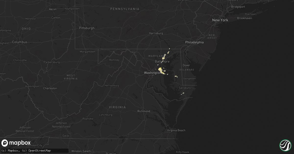
Hail Map in Maryland on June 27, 2023
Get this storm
June 27 map
$229
one time, instant access
Download today. No call, no setup
Keep the $229
Bought the map and want the full workflow? Apply the entire $229 to a subscription within 7 days. None of it is wasted.
Every map, not just this one
This buys you this map. Subscription and you get every map we run, in the markets you choose from a few cities to whole states to nationwide. Plus real-time alerts the moment a storm fires.
Contact data
Name, contact info, occupancy, even credit band for addresses in the footprint. You go from where it hit to who to call.
Become the source they trust
Unlimited branding weather history reports on demand. You already have the documented answer ready for the property owner, and you are the one who showed up with it.
Property data and RoofTrace estimates
Pull up any address you have got, its value and the exact code rules for that jurisdiction, straight from One Click Code. Then RoofTrace estimates the squares, pitch, and roof value, priced the way you price.
Storm reports in Maryland
Maryland
| Date | Description |
|---|---|
| 06/27/20234:39 PM CDT | Large tree down on glebe rd in easton. Time estimated from radar. |
| 06/27/20234:39 PM CDT | Large tree down on chapel rd. In easton. Time estimated from radar. |
| 06/27/20233:12 PM CDT | Quarter size hail was reported in middle river. |
| 06/27/20232:54 PM CDT | Quarter size hail was reported in birdsville. |
| 06/27/20232:40 PM CDT | A local report indicates 1.00 inch wind near 1 N Fullerton |
| 06/27/20232:31 PM CDT | Delayed report. Off-duty nws meteorologist reports quarter-sized hail in crofton. |
| 06/27/20232:25 PM CDT | Trees blew down blocking a couple of roadways in odenton. |
| 06/27/20232:15 PM CDT | Half dollar size hail was reported in the 2600 block of april dawn way in gambrills. |
| 06/27/20232:09 PM CDT | Quarter size hail was reported in piney orchard near odenton. |
| 06/27/20231:40 PM CDT | Trees blew down near street... Near the intersection of mill green road and md-646 prospect road... And along md-136 whiteford road. |
| 06/27/20231:01 PM CDT | A tree fell onto a gutter at a residence along kathleen drive in fallston. |
All States Impacted by Hail Map on June 27, 2023
Cities Impacted by Hail Map on June 27, 2023
- Orlando, OK
- Mulhall, OK
- Edmond, OK
- Guthrie, OK
- Crescent, OK
- Wellston, OK
- Chandler, OK
- Jones, OK
- Sparks, OK
- Mcloud, OK
- Arcadia, OK
- Coyle, OK
- Carney, OK
- Perkins, OK
- Luther, OK
- Meridian, OK
- Prague, OK
- Meeker, OK
- Stillwater, OK
- Harrah, OK
- Tryon, OK
- Boley, OK
- Paden, OK
- Okemah, OK
- Davenport, OK
- Stroud, OK
- Jennings, OK
- Bristow, OK
- Agra, OK
- Yale, OK
- Castle, OK
- Cushing, OK
- Depew, OK
- Kellyville, OK
- Ripley, OK
- Drumright, OK
- Mannford, OK
- Glencoe, OK
- Inman, KS
- Moundridge, KS
- South Hutchinson, KS
- Hutchinson, KS
- Buhler, KS
- Burrton, KS
- Newton, KS
- Haven, KS
- Halstead, KS
- Hesston, KS
- Bentley, KS
- Mount Hope, KS
- Colwich, KS
- Sedgwick, KS
- Valley Center, KS
- Andale, KS
- Nickerson, KS
- Sterling, KS
- Wichita, KS
- Kechi, KS
- Maize, KS
- Sapulpa, OK
- Beggs, OK
- Mounds, OK
- Hanna, OK
- Weleetka, OK
- Okmulgee, OK
- Henryetta, OK
- Eufaula, OK
- Canadian, OK
- Checotah, OK
- Oktaha, OK
- Council Hill, OK
- Morris, OK
- Boynton, OK
- Stigler, OK
- Kinta, OK
- Whitefield, OK
- Porum, OK
- Quinton, OK
- Warner, OK
- Washington, AR
- Ozan, AR
- Badger, MN
- Alma, AR
- Lavaca, AR
- Nashville, AR
- Booneville, AR
- Waldron, AR
- Murfreesboro, AR
- Hope, AR
- Windom, KS
- Geneseo, KS
- Little River, KS
- Holtwood, PA
- Pequea, PA
- Muldrow, OK
- Lyons, KS
- Mcpherson, KS
- Marquette, KS
- Arkoma, OK
- Barling, AR
- Greenwood, AR
- Fort Smith, AR
- Midland, AR
- Mansfield, AR
- Hackett, AR
- Hartford, AR
- Cameron, OK
- Huntington, AR
- Conestoga, PA
- Poteau, OK
- Yukon, OK
- Pocola, OK
- Gurdon, AR
- Okolona, AR
- Columbus, AR
- Oklahoma City, OK
- Spencer, OK
- McCaskill, AR
- Covington, OK
- Odenton, MD
- Gambrills, MD
- Bowie, MD
- Millersville, MD
- Crofton, MD
- Spearfish, SD
- Belle Fourche, SD
- Saint Onge, SD
- Baltimore, MD
- Towson, MD
- Parkville, MD
- Nottingham, MD
- Davidsonville, MD
- Edgewater, MD
- Harwood, MD
- Nisland, SD
- Vale, SD
- Newell, SD
- Walsh, CO
- Nemo, SD
- Deadwood, SD
- Piedmont, SD
- Black Hawk, SD
- Rapid City, SD
- Sundance, WY
- Moorcroft, WY
- Lead, SD
- Caputa, SD
- Hermosa, SD
- Bridgeport, NE
- Bayard, NE
- Broadwater, NE
- Portland, AR
- Eudora, AR
- Hollandale, MS
- Greenville, MS
- Lake Village, AR
- Parkdale, AR
- Glen Allan, MS
- Chatham, MS
- Montrose, AR
- Lake Providence, LA
- Rolling Fork, MS
- Mayersville, MS
- Cary, MS
- Valley Park, MS
- Holly Bluff, MS
- Yazoo City, MS
- Redwood, MS
- Anguilla, MS
- Box Elder, SD
- New Underwood, SD
- Sturgis, SD
- Satartia, MS
- Bentonia, MS
- Vicksburg, MS
- Glen Saint Mary, FL
- Raiford, FL
- Wasta, SD
- Owanka, SD
- Wall, SD
- Lisco, NE
- Macclenny, FL
- Guymon, OK
- Hooker, OK
- Jacksonville, FL
- Osage, WY
- Upton, WY
- Northome, MN
- Blackduck, MN
- Lake City, FL
- Wellborn, FL
- Clayton, NM
- Hampton, AR
- Delhi, LA
- Live Oak, FL
- Lee, FL
- Shickshinny, PA
- Wapwallopen, PA
- Berwick, PA
- Virginia Beach, VA
- Middletown, DE
- Mud Butte, SD
- Annapolis, MD
- Junction City, AR
- El Dorado, AR
- Kenton, OK
- Meadow, SD
- Hamburg, AR
- Morehead City, NC
- Beaufort, NC
- Williams, MN
- Roosevelt, MN
- Boise City, OK
- Boyes, MT
- Atglen, PA
- Quarryville, PA
- Cochranville, PA
- Kirkwood, PA
- Christiana, PA
- Springfield, CO
- Two Buttes, CO
- Tallulah, LA
- Utica, MS
- Beulah, WY
- Devils Tower, WY
- Faith, SD
- Rozet, WY
- Brusett, MT
- Fort Peck, MT
- Westby, MT
- Warren, AR
- Alzada, MT
- Hulett, WY
- Oak Grove, LA
- Oakton, VA
- Herndon, VA
- Reston, VA
- Monticello, AR
- Harvey, AR
- Havelock, NC
- Jackson, AL
- Saint Stephens, AL
- Greenville, FL
- Hague, VA
- Forest Hill, MD
- Bel Air, MD
- Kaycee, WY
- Delta, PA
- Whiteford, MD
- Campo, CO
- McLean, VA
- Vienna, VA
- Great Falls, VA
- Stevensville, MD
- Salem, NJ
- Chesapeake, VA
- Thomasville, AL
- Townsend, DE
- Fallston, MD
- Baldwin, MD
- Fort George G Meade, MD
- Strong, AR
- Hammond, MT
- Hermitage, AR
- West River, MD
- Upper Marlboro, MD
- Crownsville, MD
- Galesville, MD
- Shady Side, MD
- Jonestown, PA
- Lebanon, PA
- Auburn, WY
- Phoenix, MD
- Lutherville Timonium, MD
- Hydes, MD
- Glen Arm, MD
- Street, MD
- Halethorpe, MD
- Brooklyn, MD
- Madison, FL
- Wolf Point, MT
- Mora, MN
- Isle, MN
- Halifax, PA
- Sheridan, AR
- Marion, LA
- Louann, AR
- Hot Springs Village, AR
- Crossett, AR
- Banks, AR
- Hot Springs National Park, AR
- Fredericksburg, PA
- Laurel, MD
- Jessup, MD
- Elkridge, MD
- Haynesville, LA
- Grenora, ND
- Frazer, MT
- Oshkosh, NE
- Holyoke, CO
- Wray, CO
- Champion, NE
- Goodwell, OK
- Gruver, TX
- Lewellen, NE
- Kadoka, SD
- Quinn, SD
- Turpin, OK
- Balko, OK
- Beaver, OK
- Hardesty, OK
- Hugoton, KS
- Rolla, KS
- Keyes, OK
- Texhoma, OK
- Liberal, KS
- Moscow, KS
- Satanta, KS
- Perryton, TX
- Forgan, OK
- Interior, SD
- Belvidere, SD
- Long Valley, SD
- Philip, SD
- Kyle, SD
- Wanblee, SD
- Plains, KS
- Meade, KS
- Spearman, TX
- Sunray, TX
- Stratford, TX
- Tyrone, OK
- Kismet, KS
- Copeland, KS
- Sublette, KS
- Fowler, KS
- Cimarron, KS
- Ensign, KS
- Montezuma, KS
- Gate, OK
- Englewood, KS
- Dodge City, KS
- Minneola, KS
- Lemoyne, NE
- Arthur, NE
- Sutherland, NE
- Tryon, NE
- Haigler, NE
- Parks, NE
- Lakota, ND
- Michigan, ND
- Petersburg, ND
- Fordville, ND
- Lankin, ND
- Sheyenne, ND
- Saint Michael, ND
- Oberon, ND
- Fort Totten, ND
- Ashland, KS
- Wright, KS
- Spearville, KS
- Ford, KS
- Bucklin, KS
- Protection, KS
- Mullinville, KS
- Rosston, OK
- Buffalo, OK
- Murdo, SD
- White River, SD
- Norris, SD
- Parmelee, SD
- Saint Francis, SD
- Martin, SD
- Tuthill, SD
- Merriman, NE
- Mission, SD
- Rosebud, SD
- Cody, NE
- Greensburg, KS
- Offerle, KS
- Freedom, OK
- Coldwater, KS
- Alva, OK
- Dahlen, ND
- Cando, ND
- Lake City, KS
- Kilgore, NE
- Baudette, MN
- Kiowa, KS
- Cherokee, OK
- Hardtner, KS
- Valentine, NE
- Nenzel, NE
- Crookston, NE
- Mooreland, OK
- Waynoka, OK
- Burlington, OK
- Amorita, OK
- Medicine Lodge, KS
- Hazelton, KS
- Manchester, OK
- Anthony, KS
- Attica, KS
- Danville, KS
- Harper, KS
- Waldron, KS
- Jet, OK
- Nash, OK
- Freeport, KS
- Wakita, OK
- Bluff City, KS
- Caldwell, KS
- Argonia, KS
- Medford, OK
- Milan, KS
- South Haven, KS
- Wellington, KS
- Mayfield, KS
- Braman, OK
- Oxford, KS
- Newkirk, OK
- Geuda Springs, KS
- Arkansas City, KS
- Kaw City, OK
- Ponca City, OK
- Udall, KS
- Winfield, KS
- Belle Plaine, KS
- Maple City, KS
- Leeds, ND
- Churchs Ferry, ND
- Rolla, ND
- Hansboro, ND
- Ismay, MT
- Carson, ND
- Dunn Center, ND
- Penn, ND
- Amite, LA
- Loranger, LA
- Husser, LA
- Waterproof, LA
- Ferriday, LA
- Clayton, LA
- Warsaw, VA
- Kinsale, VA
- Texline, TX
- Regan, ND
- Waynesboro, MS
- Pekin, ND
- Mchenry, ND
- Tolna, ND
- McLaughlin, SD
- Scenic, SD
- Dupree, SD
- Lantry, SD
- Eagle Butte, SD
- Lawtey, FL
- Sondheimer, LA
- Newellton, LA
- Dalhart, TX
- Grenville, NM
- Medora, ND
- Howes, SD
- Middleburg, FL
- Chatom, AL
- Manns Harbor, NC
- McIntosh, SD
- Roy, MT
- Elkhart, KS
- Ely, MN
- Transylvania, LA
- Yuma, CO
- Eckley, CO
- Babbitt, MN
- Perth, ND
- Columbia, NC
- Millry, AL
- Franklinton, LA
- Folsom, LA
- Princess Anne, MD
- State Line, MS
- Sidney, MT
- Raymond, MS
- Easton, MD
- Rayville, LA
- Imperial, NE
- Sedan, NM
- Sterlington, LA
- Silas, AL
- Saint Augustine, FL
- Killdeer, ND
- Wood, SD
- Green Cove Springs, FL
- Severna Park, MD
- Arnold, MD
- Porcupine, SD
- Bancroft, ID
- Sanderson, FL
- Jones, LA
- Starke, FL
- Saint Johns, FL
- Fleming Island, FL
- Orange Park, FL
- Westover, MD
- Madison, MS
- Canton, MS
- Lucedale, MS
- Pioneer, LA
- Knotts Island, NC
- Corolla, NC
- Beltsville, MD
- Fruitdale, AL
- Hattiesburg, MS
- Purvis, MS
- Preston, MD
- Glenfield, ND
- Milesville, SD
- Robertsdale, AL
- Burden, KS
- Dexter, KS
- Shidler, OK
- Burbank, OK
- Cambridge, KS
- Cedar Vale, KS
- Fairfax, OK
- Wynona, OK
- Pawhuska, OK
- Blackwell, OK
- Sedan, KS
- Chautauqua, KS
- Peru, KS
- Barnsdall, OK
- Bartlesville, OK
- Dewey, OK
- Copan, OK
- Ochelata, OK
- Golden Valley, ND
- Chelsea, OK
- Marland, OK
- Pocahontas, IA
- Palmer, IA
- Mcclusky, ND
- Hazen, ND
- Ericson, NE
- Big Cabin, OK
- Winner, SD
- Conway Springs, KS
- Delaware, OK
- Nowata, OK
- Red Rock, OK
- Burwell, NE
- Hominy, OK
- Scotia, NE
- Pawnee, OK
- Skiatook, OK
- Osage, OK
- Laverne, OK
- Glenrock, WY
- Springview, NE
- Mott, ND
- Iroquois, SD
- Hitchcock, SD
- Bartlett, NE
- Spalding, NE
- Greeley, NE
- Ralston, OK


