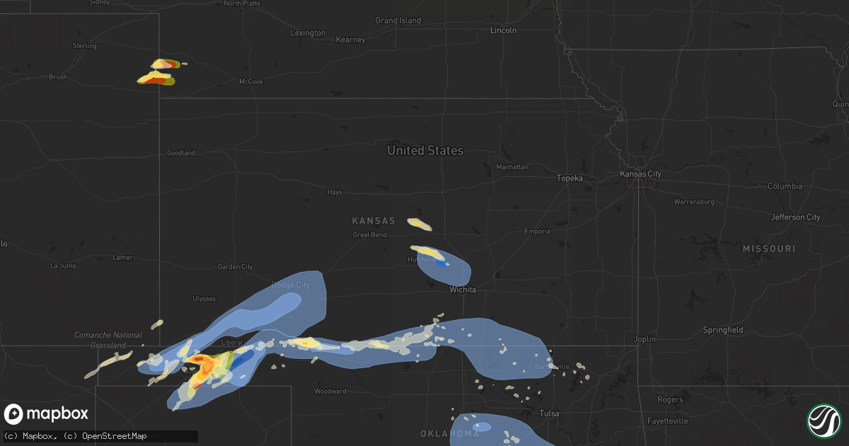
Hail Map in Kansas on June 27, 2023
Get this storm
June 27 map
$229
one time, instant access
Download today. No call, no setup
Keep the $229
Bought the map and want the full workflow? Apply the entire $229 to a subscription within 7 days. None of it is wasted.
Every map, not just this one
This buys you this map. Subscription and you get every map we run, in the markets you choose from a few cities to whole states to nationwide. Plus real-time alerts the moment a storm fires.
Contact data
Name, contact info, occupancy, even credit band for addresses in the footprint. You go from where it hit to who to call.
Become the source they trust
Unlimited branding weather history reports on demand. You already have the documented answer ready for the property owner, and you are the one who showed up with it.
Property data and RoofTrace estimates
Pull up any address you have got, its value and the exact code rules for that jurisdiction, straight from One Click Code. Then RoofTrace estimates the squares, pitch, and roof value, priced the way you price.
Storm reports in Kansas
Kansas
| Date | Description |
|---|---|
| 06/27/20239:11 AM CDT | Nickel hail. |
| 06/27/20238:56 AM CDT | A local report indicates 70 MPH wind near Sedgwick |
| 06/27/20238:34 AM CDT | A local report indicates 80 MPH wind near Burrton |
| 06/27/20238:34 AM CDT | Tree branches of three to four inches in diameter were reported down via a picture on facebook. Time is based on wind report. |
| 06/27/20238:18 AM CDT | A local report indicates 64 MPH wind near Hutchinson Airport ASOS |
| 06/26/202311:38 PM CDT | At strother field. |
| 06/26/202310:55 PM CDT | 60-65mph. |
| 06/26/202310:40 PM CDT | Measured by kansas mesonet. |
| 06/26/202310:35 PM CDT | A local report indicates 60 MPH wind near 2 S Anthony |
| 06/26/202310:30 PM CDT | A local report indicates 60 MPH wind near 1.5 S Anthony |
| 06/26/202310:15 PM CDT | Emergency manager reported 60 mph gust in byers. Town is without power. |
| 06/26/20239:30 PM CDT | Tree limbs down. Time est from radar. |
| 06/26/20239:30 PM CDT | Tree limbs down... Wire down. Time est from radar. |
| 06/26/20239:30 PM CDT | Asos station kddc dodge city regional airport. |
| 06/26/20239:15 PM CDT | Mesonet station dw9907 bloom. |
| 06/26/20239:08 PM CDT | Asos station kddc dodge city regional airport. |
| 06/26/20239:00 PM CDT | Mesonet station dw9907 bloom. |
| 06/26/20239:00 PM CDT | Report of a semi blown over on highway 34 near mile marker 28. |
| 06/26/20239:00 PM CDT | Report received through social media. |
| 06/26/20238:59 PM CDT | Mesonet station up313 2.1 w minneola |
| 06/26/20238:55 PM CDT | Mesonet station gw3433 dodge city. |
| 06/26/20238:47 PM CDT | Mesonet station up835 3.0 w kingsdown |
| 06/26/20238:45 PM CDT | Mesonet station dw9907 bloom. |
| 06/26/20238:43 PM CDT | Multiple tree limbs down 3 inches and bigger. |
| 06/26/20238:39 PM CDT | Mesonet station up313 2.1 w minneola |
| 06/26/20238:34 PM CDT | Mesonet station up313 2.1 w minneola |
| 06/26/20238:32 PM CDT | Semi blown over on highway 400 at mile marker 130. |
| 06/26/20238:27 PM CDT | Mesonet station up367 4.9 ne meade |
| 06/26/20238:25 PM CDT | A local report indicates 100 MPH wind near 7 NE Missler |
| 06/26/20238:23 PM CDT | Wind speeds ranged from 60 to 70 mph. Meade is currently without power. |
| 06/26/20238:15 PM CDT | A local report indicates 70 MPH wind near 4 N Meade |
| 06/26/20238:05 PM CDT | Mesonet station ur350 4.4 ne hayne |
| 06/26/20237:20 PM CDT | A local report indicates 80 MPH wind near 8 SSE Feterita |
| 06/26/20237:12 PM CDT | A local report indicates 80 MPH wind near 9 S Hugoton |
All States Impacted by Hail Map on June 27, 2023
Cities Impacted by Hail Map on June 27, 2023
- Orlando, OK
- Mulhall, OK
- Edmond, OK
- Guthrie, OK
- Crescent, OK
- Wellston, OK
- Chandler, OK
- Jones, OK
- Sparks, OK
- Mcloud, OK
- Arcadia, OK
- Coyle, OK
- Carney, OK
- Perkins, OK
- Luther, OK
- Meridian, OK
- Prague, OK
- Meeker, OK
- Stillwater, OK
- Harrah, OK
- Tryon, OK
- Boley, OK
- Paden, OK
- Okemah, OK
- Davenport, OK
- Stroud, OK
- Jennings, OK
- Bristow, OK
- Agra, OK
- Yale, OK
- Castle, OK
- Cushing, OK
- Depew, OK
- Kellyville, OK
- Ripley, OK
- Drumright, OK
- Mannford, OK
- Glencoe, OK
- Inman, KS
- Moundridge, KS
- South Hutchinson, KS
- Hutchinson, KS
- Buhler, KS
- Burrton, KS
- Newton, KS
- Haven, KS
- Halstead, KS
- Hesston, KS
- Bentley, KS
- Mount Hope, KS
- Colwich, KS
- Sedgwick, KS
- Valley Center, KS
- Andale, KS
- Nickerson, KS
- Sterling, KS
- Wichita, KS
- Kechi, KS
- Maize, KS
- Sapulpa, OK
- Beggs, OK
- Mounds, OK
- Hanna, OK
- Weleetka, OK
- Okmulgee, OK
- Henryetta, OK
- Eufaula, OK
- Canadian, OK
- Checotah, OK
- Oktaha, OK
- Council Hill, OK
- Morris, OK
- Boynton, OK
- Stigler, OK
- Kinta, OK
- Whitefield, OK
- Porum, OK
- Quinton, OK
- Warner, OK
- Washington, AR
- Ozan, AR
- Badger, MN
- Alma, AR
- Lavaca, AR
- Nashville, AR
- Booneville, AR
- Waldron, AR
- Murfreesboro, AR
- Hope, AR
- Windom, KS
- Geneseo, KS
- Little River, KS
- Holtwood, PA
- Pequea, PA
- Muldrow, OK
- Lyons, KS
- Mcpherson, KS
- Marquette, KS
- Arkoma, OK
- Barling, AR
- Greenwood, AR
- Fort Smith, AR
- Midland, AR
- Mansfield, AR
- Hackett, AR
- Hartford, AR
- Cameron, OK
- Huntington, AR
- Conestoga, PA
- Poteau, OK
- Yukon, OK
- Pocola, OK
- Gurdon, AR
- Okolona, AR
- Columbus, AR
- Oklahoma City, OK
- Spencer, OK
- McCaskill, AR
- Covington, OK
- Odenton, MD
- Gambrills, MD
- Bowie, MD
- Millersville, MD
- Crofton, MD
- Spearfish, SD
- Belle Fourche, SD
- Saint Onge, SD
- Baltimore, MD
- Towson, MD
- Parkville, MD
- Nottingham, MD
- Davidsonville, MD
- Edgewater, MD
- Harwood, MD
- Nisland, SD
- Vale, SD
- Newell, SD
- Walsh, CO
- Nemo, SD
- Deadwood, SD
- Piedmont, SD
- Black Hawk, SD
- Rapid City, SD
- Sundance, WY
- Moorcroft, WY
- Lead, SD
- Caputa, SD
- Hermosa, SD
- Bridgeport, NE
- Bayard, NE
- Broadwater, NE
- Portland, AR
- Eudora, AR
- Hollandale, MS
- Greenville, MS
- Lake Village, AR
- Parkdale, AR
- Glen Allan, MS
- Chatham, MS
- Montrose, AR
- Lake Providence, LA
- Rolling Fork, MS
- Mayersville, MS
- Cary, MS
- Valley Park, MS
- Holly Bluff, MS
- Yazoo City, MS
- Redwood, MS
- Anguilla, MS
- Box Elder, SD
- New Underwood, SD
- Sturgis, SD
- Satartia, MS
- Bentonia, MS
- Vicksburg, MS
- Glen Saint Mary, FL
- Raiford, FL
- Wasta, SD
- Owanka, SD
- Wall, SD
- Lisco, NE
- Macclenny, FL
- Guymon, OK
- Hooker, OK
- Jacksonville, FL
- Osage, WY
- Upton, WY
- Northome, MN
- Blackduck, MN
- Lake City, FL
- Wellborn, FL
- Clayton, NM
- Hampton, AR
- Delhi, LA
- Live Oak, FL
- Lee, FL
- Shickshinny, PA
- Wapwallopen, PA
- Berwick, PA
- Virginia Beach, VA
- Middletown, DE
- Mud Butte, SD
- Annapolis, MD
- Junction City, AR
- El Dorado, AR
- Kenton, OK
- Meadow, SD
- Hamburg, AR
- Morehead City, NC
- Beaufort, NC
- Williams, MN
- Roosevelt, MN
- Boise City, OK
- Boyes, MT
- Atglen, PA
- Quarryville, PA
- Cochranville, PA
- Kirkwood, PA
- Christiana, PA
- Springfield, CO
- Two Buttes, CO
- Tallulah, LA
- Utica, MS
- Beulah, WY
- Devils Tower, WY
- Faith, SD
- Rozet, WY
- Brusett, MT
- Fort Peck, MT
- Westby, MT
- Warren, AR
- Alzada, MT
- Hulett, WY
- Oak Grove, LA
- Oakton, VA
- Herndon, VA
- Reston, VA
- Monticello, AR
- Harvey, AR
- Havelock, NC
- Jackson, AL
- Saint Stephens, AL
- Greenville, FL
- Hague, VA
- Forest Hill, MD
- Bel Air, MD
- Kaycee, WY
- Delta, PA
- Whiteford, MD
- Campo, CO
- McLean, VA
- Vienna, VA
- Great Falls, VA
- Stevensville, MD
- Salem, NJ
- Chesapeake, VA
- Thomasville, AL
- Townsend, DE
- Fallston, MD
- Baldwin, MD
- Fort George G Meade, MD
- Strong, AR
- Hammond, MT
- Hermitage, AR
- West River, MD
- Upper Marlboro, MD
- Crownsville, MD
- Galesville, MD
- Shady Side, MD
- Jonestown, PA
- Lebanon, PA
- Auburn, WY
- Phoenix, MD
- Lutherville Timonium, MD
- Hydes, MD
- Glen Arm, MD
- Street, MD
- Halethorpe, MD
- Brooklyn, MD
- Madison, FL
- Wolf Point, MT
- Mora, MN
- Isle, MN
- Halifax, PA
- Sheridan, AR
- Marion, LA
- Louann, AR
- Hot Springs Village, AR
- Crossett, AR
- Banks, AR
- Hot Springs National Park, AR
- Fredericksburg, PA
- Laurel, MD
- Jessup, MD
- Elkridge, MD
- Haynesville, LA
- Grenora, ND
- Frazer, MT
- Oshkosh, NE
- Holyoke, CO
- Wray, CO
- Champion, NE
- Goodwell, OK
- Gruver, TX
- Lewellen, NE
- Kadoka, SD
- Quinn, SD
- Turpin, OK
- Balko, OK
- Beaver, OK
- Hardesty, OK
- Hugoton, KS
- Rolla, KS
- Keyes, OK
- Texhoma, OK
- Liberal, KS
- Moscow, KS
- Satanta, KS
- Perryton, TX
- Forgan, OK
- Interior, SD
- Belvidere, SD
- Long Valley, SD
- Philip, SD
- Kyle, SD
- Wanblee, SD
- Plains, KS
- Meade, KS
- Spearman, TX
- Sunray, TX
- Stratford, TX
- Tyrone, OK
- Kismet, KS
- Copeland, KS
- Sublette, KS
- Fowler, KS
- Cimarron, KS
- Ensign, KS
- Montezuma, KS
- Gate, OK
- Englewood, KS
- Dodge City, KS
- Minneola, KS
- Lemoyne, NE
- Arthur, NE
- Sutherland, NE
- Tryon, NE
- Haigler, NE
- Parks, NE
- Lakota, ND
- Michigan, ND
- Petersburg, ND
- Fordville, ND
- Lankin, ND
- Sheyenne, ND
- Saint Michael, ND
- Oberon, ND
- Fort Totten, ND
- Ashland, KS
- Wright, KS
- Spearville, KS
- Ford, KS
- Bucklin, KS
- Protection, KS
- Mullinville, KS
- Rosston, OK
- Buffalo, OK
- Murdo, SD
- White River, SD
- Norris, SD
- Parmelee, SD
- Saint Francis, SD
- Martin, SD
- Tuthill, SD
- Merriman, NE
- Mission, SD
- Rosebud, SD
- Cody, NE
- Greensburg, KS
- Offerle, KS
- Freedom, OK
- Coldwater, KS
- Alva, OK
- Dahlen, ND
- Cando, ND
- Lake City, KS
- Kilgore, NE
- Baudette, MN
- Kiowa, KS
- Cherokee, OK
- Hardtner, KS
- Valentine, NE
- Nenzel, NE
- Crookston, NE
- Mooreland, OK
- Waynoka, OK
- Burlington, OK
- Amorita, OK
- Medicine Lodge, KS
- Hazelton, KS
- Manchester, OK
- Anthony, KS
- Attica, KS
- Danville, KS
- Harper, KS
- Waldron, KS
- Jet, OK
- Nash, OK
- Freeport, KS
- Wakita, OK
- Bluff City, KS
- Caldwell, KS
- Argonia, KS
- Medford, OK
- Milan, KS
- South Haven, KS
- Wellington, KS
- Mayfield, KS
- Braman, OK
- Oxford, KS
- Newkirk, OK
- Geuda Springs, KS
- Arkansas City, KS
- Kaw City, OK
- Ponca City, OK
- Udall, KS
- Winfield, KS
- Belle Plaine, KS
- Maple City, KS
- Leeds, ND
- Churchs Ferry, ND
- Rolla, ND
- Hansboro, ND
- Ismay, MT
- Carson, ND
- Dunn Center, ND
- Penn, ND
- Amite, LA
- Loranger, LA
- Husser, LA
- Waterproof, LA
- Ferriday, LA
- Clayton, LA
- Warsaw, VA
- Kinsale, VA
- Texline, TX
- Regan, ND
- Waynesboro, MS
- Pekin, ND
- Mchenry, ND
- Tolna, ND
- McLaughlin, SD
- Scenic, SD
- Dupree, SD
- Lantry, SD
- Eagle Butte, SD
- Lawtey, FL
- Sondheimer, LA
- Newellton, LA
- Dalhart, TX
- Grenville, NM
- Medora, ND
- Howes, SD
- Middleburg, FL
- Chatom, AL
- Manns Harbor, NC
- McIntosh, SD
- Roy, MT
- Elkhart, KS
- Ely, MN
- Transylvania, LA
- Yuma, CO
- Eckley, CO
- Babbitt, MN
- Perth, ND
- Columbia, NC
- Millry, AL
- Franklinton, LA
- Folsom, LA
- Princess Anne, MD
- State Line, MS
- Sidney, MT
- Raymond, MS
- Easton, MD
- Rayville, LA
- Imperial, NE
- Sedan, NM
- Sterlington, LA
- Silas, AL
- Saint Augustine, FL
- Killdeer, ND
- Wood, SD
- Green Cove Springs, FL
- Severna Park, MD
- Arnold, MD
- Porcupine, SD
- Bancroft, ID
- Sanderson, FL
- Jones, LA
- Starke, FL
- Saint Johns, FL
- Fleming Island, FL
- Orange Park, FL
- Westover, MD
- Madison, MS
- Canton, MS
- Lucedale, MS
- Pioneer, LA
- Knotts Island, NC
- Corolla, NC
- Beltsville, MD
- Fruitdale, AL
- Hattiesburg, MS
- Purvis, MS
- Preston, MD
- Glenfield, ND
- Milesville, SD
- Robertsdale, AL
- Burden, KS
- Dexter, KS
- Shidler, OK
- Burbank, OK
- Cambridge, KS
- Cedar Vale, KS
- Fairfax, OK
- Wynona, OK
- Pawhuska, OK
- Blackwell, OK
- Sedan, KS
- Chautauqua, KS
- Peru, KS
- Barnsdall, OK
- Bartlesville, OK
- Dewey, OK
- Copan, OK
- Ochelata, OK
- Golden Valley, ND
- Chelsea, OK
- Marland, OK
- Pocahontas, IA
- Palmer, IA
- Mcclusky, ND
- Hazen, ND
- Ericson, NE
- Big Cabin, OK
- Winner, SD
- Conway Springs, KS
- Delaware, OK
- Nowata, OK
- Red Rock, OK
- Burwell, NE
- Hominy, OK
- Scotia, NE
- Pawnee, OK
- Skiatook, OK
- Osage, OK
- Laverne, OK
- Glenrock, WY
- Springview, NE
- Mott, ND
- Iroquois, SD
- Hitchcock, SD
- Bartlett, NE
- Spalding, NE
- Greeley, NE
- Ralston, OK


