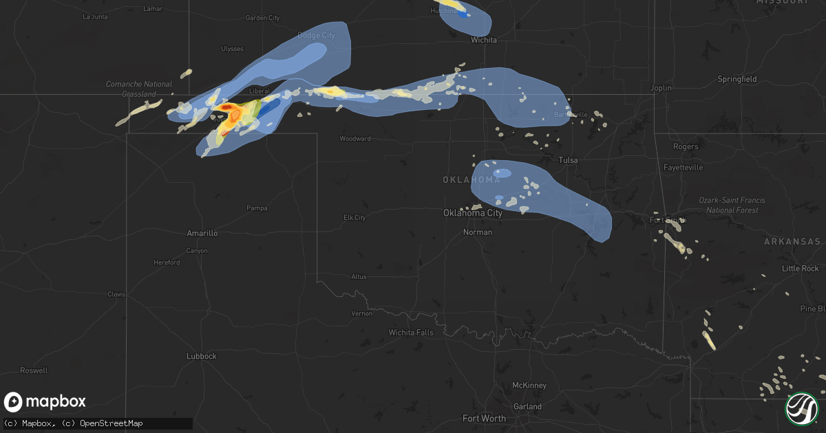
Hail Map in Oklahoma on June 27, 2023
Get this storm
June 27 map
$229
one time, instant access
Download today. No call, no setup
Keep the $229
Bought the map and want the full workflow? Apply the entire $229 to a subscription within 7 days. None of it is wasted.
Every map, not just this one
This buys you this map. Subscription and you get every map we run, in the markets you choose from a few cities to whole states to nationwide. Plus real-time alerts the moment a storm fires.
Contact data
Name, contact info, occupancy, even credit band for addresses in the footprint. You go from where it hit to who to call.
Become the source they trust
Unlimited branding weather history reports on demand. You already have the documented answer ready for the property owner, and you are the one who showed up with it.
Property data and RoofTrace estimates
Pull up any address you have got, its value and the exact code rules for that jurisdiction, straight from One Click Code. Then RoofTrace estimates the squares, pitch, and roof value, priced the way you price.
Storm reports in Oklahoma
Oklahoma
| Date | Description |
|---|---|
| 06/27/20236:47 PM CDT | Photo submitted via social media. |
| 06/27/20236:46 PM CDT | Report from mping: grapefruit |
| 06/27/20236:31 PM CDT | Photo submitted via social media. |
| 06/27/20236:30 PM CDT | Report of downed telephone poles on the northside of hwy 56. |
| 06/27/20236:11 PM CDT | A local report indicates 1.75 inch wind near 6 SE Hough |
| 06/27/20236:11 PM CDT | Photo submitted via social media. |
| 06/27/202311:47 AM CDT | Power line down on hwy 9a / main street in arkoma. Radar estimated time. |
| 06/27/202310:15 AM CDT | A local report indicates 59 MPH wind near Checotah |
| 06/27/20239:09 AM CDT | A local report indicates 59 MPH wind near 4 SE Bristow |
| 06/27/20239:00 AM CDT | A local report indicates 60 MPH wind near Oilton |
| 06/27/20239:00 AM CDT | A local report indicates 60 MPH wind near Oilton |
| 06/27/20238:55 AM CDT | A local report indicates 66 MPH wind near 3 NE Chandler |
| 06/27/20238:30 AM CDT | A local report indicates 79 MPH wind near 2 NNW Perkins |
| 06/27/20238:30 AM CDT | Outbuilding roofs and trees damaged. |
| 06/27/20238:24 AM CDT | Reported by broken arrow em. |
| 06/27/20238:20 AM CDT | A local report indicates 60 MPH wind near 5 SSW Lake Carl Blackwe |
| 06/27/20237:55 AM CDT | A local report indicates 58 MPH wind near 3 SE Breckenridge |
| 06/26/202311:55 PM CDT | A local report indicates 63 MPH wind near 8 E Newkirk |
| 06/26/202310:00 PM CDT | Freedom mesonet. |
| 06/26/20239:50 PM CDT | May ranch mesonet. |
| 06/26/20238:05 PM CDT | Highest wind gust measured before data was lost for 15 minutes. |
| 06/26/20237:56 PM CDT | Trees down in forgan... Winds estimated to be around 80 mph. |
| 06/26/20237:47 PM CDT | Storm chaser measured with a mounted anemometer. |
| 06/26/20237:46 PM CDT | Irrigation pivot flipped just north of the highway. |
| 06/26/20237:37 PM CDT | Corrects previous tstm wnd dmg report from 6 e hardesty. Irrigation pivot flipped just north of the highway. Time was re-estimated on radar. |
| 06/26/20237:25 PM CDT | Report of barn roof sheared/blown off and downed power poles. |
| 06/26/20237:11 PM CDT | Report submitted via social media. Time estimated by radar. |
All States Impacted by Hail Map on June 27, 2023
Cities Impacted by Hail Map on June 27, 2023
- Orlando, OK
- Mulhall, OK
- Edmond, OK
- Guthrie, OK
- Crescent, OK
- Wellston, OK
- Chandler, OK
- Jones, OK
- Sparks, OK
- Mcloud, OK
- Arcadia, OK
- Coyle, OK
- Carney, OK
- Perkins, OK
- Luther, OK
- Meridian, OK
- Prague, OK
- Meeker, OK
- Stillwater, OK
- Harrah, OK
- Tryon, OK
- Boley, OK
- Paden, OK
- Okemah, OK
- Davenport, OK
- Stroud, OK
- Jennings, OK
- Bristow, OK
- Agra, OK
- Yale, OK
- Castle, OK
- Cushing, OK
- Depew, OK
- Kellyville, OK
- Ripley, OK
- Drumright, OK
- Mannford, OK
- Glencoe, OK
- Inman, KS
- Moundridge, KS
- South Hutchinson, KS
- Hutchinson, KS
- Buhler, KS
- Burrton, KS
- Newton, KS
- Haven, KS
- Halstead, KS
- Hesston, KS
- Bentley, KS
- Mount Hope, KS
- Colwich, KS
- Sedgwick, KS
- Valley Center, KS
- Andale, KS
- Nickerson, KS
- Sterling, KS
- Wichita, KS
- Kechi, KS
- Maize, KS
- Sapulpa, OK
- Beggs, OK
- Mounds, OK
- Hanna, OK
- Weleetka, OK
- Okmulgee, OK
- Henryetta, OK
- Eufaula, OK
- Canadian, OK
- Checotah, OK
- Oktaha, OK
- Council Hill, OK
- Morris, OK
- Boynton, OK
- Stigler, OK
- Kinta, OK
- Whitefield, OK
- Porum, OK
- Quinton, OK
- Warner, OK
- Washington, AR
- Ozan, AR
- Badger, MN
- Alma, AR
- Lavaca, AR
- Nashville, AR
- Booneville, AR
- Waldron, AR
- Murfreesboro, AR
- Hope, AR
- Windom, KS
- Geneseo, KS
- Little River, KS
- Holtwood, PA
- Pequea, PA
- Muldrow, OK
- Lyons, KS
- Mcpherson, KS
- Marquette, KS
- Arkoma, OK
- Barling, AR
- Greenwood, AR
- Fort Smith, AR
- Midland, AR
- Mansfield, AR
- Hackett, AR
- Hartford, AR
- Cameron, OK
- Huntington, AR
- Conestoga, PA
- Poteau, OK
- Yukon, OK
- Pocola, OK
- Gurdon, AR
- Okolona, AR
- Columbus, AR
- Oklahoma City, OK
- Spencer, OK
- McCaskill, AR
- Covington, OK
- Odenton, MD
- Gambrills, MD
- Bowie, MD
- Millersville, MD
- Crofton, MD
- Spearfish, SD
- Belle Fourche, SD
- Saint Onge, SD
- Baltimore, MD
- Towson, MD
- Parkville, MD
- Nottingham, MD
- Davidsonville, MD
- Edgewater, MD
- Harwood, MD
- Nisland, SD
- Vale, SD
- Newell, SD
- Walsh, CO
- Nemo, SD
- Deadwood, SD
- Piedmont, SD
- Black Hawk, SD
- Rapid City, SD
- Sundance, WY
- Moorcroft, WY
- Lead, SD
- Caputa, SD
- Hermosa, SD
- Bridgeport, NE
- Bayard, NE
- Broadwater, NE
- Portland, AR
- Eudora, AR
- Hollandale, MS
- Greenville, MS
- Lake Village, AR
- Parkdale, AR
- Glen Allan, MS
- Chatham, MS
- Montrose, AR
- Lake Providence, LA
- Rolling Fork, MS
- Mayersville, MS
- Cary, MS
- Valley Park, MS
- Holly Bluff, MS
- Yazoo City, MS
- Redwood, MS
- Anguilla, MS
- Box Elder, SD
- New Underwood, SD
- Sturgis, SD
- Satartia, MS
- Bentonia, MS
- Vicksburg, MS
- Glen Saint Mary, FL
- Raiford, FL
- Wasta, SD
- Owanka, SD
- Wall, SD
- Lisco, NE
- Macclenny, FL
- Guymon, OK
- Hooker, OK
- Jacksonville, FL
- Osage, WY
- Upton, WY
- Northome, MN
- Blackduck, MN
- Lake City, FL
- Wellborn, FL
- Clayton, NM
- Hampton, AR
- Delhi, LA
- Live Oak, FL
- Lee, FL
- Shickshinny, PA
- Wapwallopen, PA
- Berwick, PA
- Virginia Beach, VA
- Middletown, DE
- Mud Butte, SD
- Annapolis, MD
- Junction City, AR
- El Dorado, AR
- Kenton, OK
- Meadow, SD
- Hamburg, AR
- Morehead City, NC
- Beaufort, NC
- Williams, MN
- Roosevelt, MN
- Boise City, OK
- Boyes, MT
- Atglen, PA
- Quarryville, PA
- Cochranville, PA
- Kirkwood, PA
- Christiana, PA
- Springfield, CO
- Two Buttes, CO
- Tallulah, LA
- Utica, MS
- Beulah, WY
- Devils Tower, WY
- Faith, SD
- Rozet, WY
- Brusett, MT
- Fort Peck, MT
- Westby, MT
- Warren, AR
- Alzada, MT
- Hulett, WY
- Oak Grove, LA
- Oakton, VA
- Herndon, VA
- Reston, VA
- Monticello, AR
- Harvey, AR
- Havelock, NC
- Jackson, AL
- Saint Stephens, AL
- Greenville, FL
- Hague, VA
- Forest Hill, MD
- Bel Air, MD
- Kaycee, WY
- Delta, PA
- Whiteford, MD
- Campo, CO
- McLean, VA
- Vienna, VA
- Great Falls, VA
- Stevensville, MD
- Salem, NJ
- Chesapeake, VA
- Thomasville, AL
- Townsend, DE
- Fallston, MD
- Baldwin, MD
- Fort George G Meade, MD
- Strong, AR
- Hammond, MT
- Hermitage, AR
- West River, MD
- Upper Marlboro, MD
- Crownsville, MD
- Galesville, MD
- Shady Side, MD
- Jonestown, PA
- Lebanon, PA
- Auburn, WY
- Phoenix, MD
- Lutherville Timonium, MD
- Hydes, MD
- Glen Arm, MD
- Street, MD
- Halethorpe, MD
- Brooklyn, MD
- Madison, FL
- Wolf Point, MT
- Mora, MN
- Isle, MN
- Halifax, PA
- Sheridan, AR
- Marion, LA
- Louann, AR
- Hot Springs Village, AR
- Crossett, AR
- Banks, AR
- Hot Springs National Park, AR
- Fredericksburg, PA
- Laurel, MD
- Jessup, MD
- Elkridge, MD
- Haynesville, LA
- Grenora, ND
- Frazer, MT
- Oshkosh, NE
- Holyoke, CO
- Wray, CO
- Champion, NE
- Goodwell, OK
- Gruver, TX
- Lewellen, NE
- Kadoka, SD
- Quinn, SD
- Turpin, OK
- Balko, OK
- Beaver, OK
- Hardesty, OK
- Hugoton, KS
- Rolla, KS
- Keyes, OK
- Texhoma, OK
- Liberal, KS
- Moscow, KS
- Satanta, KS
- Perryton, TX
- Forgan, OK
- Interior, SD
- Belvidere, SD
- Long Valley, SD
- Philip, SD
- Kyle, SD
- Wanblee, SD
- Plains, KS
- Meade, KS
- Spearman, TX
- Sunray, TX
- Stratford, TX
- Tyrone, OK
- Kismet, KS
- Copeland, KS
- Sublette, KS
- Fowler, KS
- Cimarron, KS
- Ensign, KS
- Montezuma, KS
- Gate, OK
- Englewood, KS
- Dodge City, KS
- Minneola, KS
- Lemoyne, NE
- Arthur, NE
- Sutherland, NE
- Tryon, NE
- Haigler, NE
- Parks, NE
- Lakota, ND
- Michigan, ND
- Petersburg, ND
- Fordville, ND
- Lankin, ND
- Sheyenne, ND
- Saint Michael, ND
- Oberon, ND
- Fort Totten, ND
- Ashland, KS
- Wright, KS
- Spearville, KS
- Ford, KS
- Bucklin, KS
- Protection, KS
- Mullinville, KS
- Rosston, OK
- Buffalo, OK
- Murdo, SD
- White River, SD
- Norris, SD
- Parmelee, SD
- Saint Francis, SD
- Martin, SD
- Tuthill, SD
- Merriman, NE
- Mission, SD
- Rosebud, SD
- Cody, NE
- Greensburg, KS
- Offerle, KS
- Freedom, OK
- Coldwater, KS
- Alva, OK
- Dahlen, ND
- Cando, ND
- Lake City, KS
- Kilgore, NE
- Baudette, MN
- Kiowa, KS
- Cherokee, OK
- Hardtner, KS
- Valentine, NE
- Nenzel, NE
- Crookston, NE
- Mooreland, OK
- Waynoka, OK
- Burlington, OK
- Amorita, OK
- Medicine Lodge, KS
- Hazelton, KS
- Manchester, OK
- Anthony, KS
- Attica, KS
- Danville, KS
- Harper, KS
- Waldron, KS
- Jet, OK
- Nash, OK
- Freeport, KS
- Wakita, OK
- Bluff City, KS
- Caldwell, KS
- Argonia, KS
- Medford, OK
- Milan, KS
- South Haven, KS
- Wellington, KS
- Mayfield, KS
- Braman, OK
- Oxford, KS
- Newkirk, OK
- Geuda Springs, KS
- Arkansas City, KS
- Kaw City, OK
- Ponca City, OK
- Udall, KS
- Winfield, KS
- Belle Plaine, KS
- Maple City, KS
- Leeds, ND
- Churchs Ferry, ND
- Rolla, ND
- Hansboro, ND
- Ismay, MT
- Carson, ND
- Dunn Center, ND
- Penn, ND
- Amite, LA
- Loranger, LA
- Husser, LA
- Waterproof, LA
- Ferriday, LA
- Clayton, LA
- Warsaw, VA
- Kinsale, VA
- Texline, TX
- Regan, ND
- Waynesboro, MS
- Pekin, ND
- Mchenry, ND
- Tolna, ND
- McLaughlin, SD
- Scenic, SD
- Dupree, SD
- Lantry, SD
- Eagle Butte, SD
- Lawtey, FL
- Sondheimer, LA
- Newellton, LA
- Dalhart, TX
- Grenville, NM
- Medora, ND
- Howes, SD
- Middleburg, FL
- Chatom, AL
- Manns Harbor, NC
- McIntosh, SD
- Roy, MT
- Elkhart, KS
- Ely, MN
- Transylvania, LA
- Yuma, CO
- Eckley, CO
- Babbitt, MN
- Perth, ND
- Columbia, NC
- Millry, AL
- Franklinton, LA
- Folsom, LA
- Princess Anne, MD
- State Line, MS
- Sidney, MT
- Raymond, MS
- Easton, MD
- Rayville, LA
- Imperial, NE
- Sedan, NM
- Sterlington, LA
- Silas, AL
- Saint Augustine, FL
- Killdeer, ND
- Wood, SD
- Green Cove Springs, FL
- Severna Park, MD
- Arnold, MD
- Porcupine, SD
- Bancroft, ID
- Sanderson, FL
- Jones, LA
- Starke, FL
- Saint Johns, FL
- Fleming Island, FL
- Orange Park, FL
- Westover, MD
- Madison, MS
- Canton, MS
- Lucedale, MS
- Pioneer, LA
- Knotts Island, NC
- Corolla, NC
- Beltsville, MD
- Fruitdale, AL
- Hattiesburg, MS
- Purvis, MS
- Preston, MD
- Glenfield, ND
- Milesville, SD
- Robertsdale, AL
- Burden, KS
- Dexter, KS
- Shidler, OK
- Burbank, OK
- Cambridge, KS
- Cedar Vale, KS
- Fairfax, OK
- Wynona, OK
- Pawhuska, OK
- Blackwell, OK
- Sedan, KS
- Chautauqua, KS
- Peru, KS
- Barnsdall, OK
- Bartlesville, OK
- Dewey, OK
- Copan, OK
- Ochelata, OK
- Golden Valley, ND
- Chelsea, OK
- Marland, OK
- Pocahontas, IA
- Palmer, IA
- Mcclusky, ND
- Hazen, ND
- Ericson, NE
- Big Cabin, OK
- Winner, SD
- Conway Springs, KS
- Delaware, OK
- Nowata, OK
- Red Rock, OK
- Burwell, NE
- Hominy, OK
- Scotia, NE
- Pawnee, OK
- Skiatook, OK
- Osage, OK
- Laverne, OK
- Glenrock, WY
- Springview, NE
- Mott, ND
- Iroquois, SD
- Hitchcock, SD
- Bartlett, NE
- Spalding, NE
- Greeley, NE
- Ralston, OK


