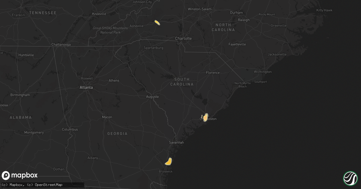
Hail Map in South Carolina on June 26, 2013
Get this storm
June 26 map
$229
one time, instant access
Download today. No call, no setup
Keep the $229
Bought the map and want the full workflow? Apply the entire $229 to a subscription within 7 days. None of it is wasted.
Every map, not just this one
This buys you this map. Subscription and you get every map we run, in the markets you choose from a few cities to whole states to nationwide. Plus real-time alerts the moment a storm fires.
Contact data
Name, contact info, occupancy, even credit band for addresses in the footprint. You go from where it hit to who to call.
Become the source they trust
Unlimited branding weather history reports on demand. You already have the documented answer ready for the property owner, and you are the one who showed up with it.
Property data and RoofTrace estimates
Pull up any address you have got, its value and the exact code rules for that jurisdiction, straight from One Click Code. Then RoofTrace estimates the squares, pitch, and roof value, priced the way you price.
Storm reports in South Carolina
South Carolina
| Date | Description |
|---|---|
| 06/26/20136:49 PM CDT | Kershaw dispatch reported power lines down in bethune. |
| 06/26/20135:52 PM CDT | Warning point reported tree down along witsell road and keans neck road. Time estimated by radar. |
| 06/26/20135:44 PM CDT | Sc highway patrol reports downed trees on wateree rd. Between debutary rd and woodside dr. |
| 06/26/20135:43 PM CDT | Warning point reported one tree down along the intersection of kinloch road and stroban road. Time estimated by radar. |
| 06/26/20135:35 PM CDT | Sc highway patrol reports trees down on heritage road near hwy 901 |
| 06/26/20135:24 PM CDT | Tree down on jasper station rd. |
| 06/26/20135:15 PM CDT | Tree down reported at the intersection of okatie highway and lowcountry drive. |
| 06/26/20135:15 PM CDT | Public reported ping pong ball sized hail on bent hickory road. |
| 06/26/20135:13 PM CDT | Public reported tree down on a house on bishop drive in west ashley. |
| 06/26/20135:05 PM CDT | Spotter reported up to tennis ball sized hail one mile south of the intersection of highway 61 and bees ferry road. |
| 06/26/20135:01 PM CDT | Law enforcement reported one tree down along bees ferry road and shadowmoss parkway. Time estimated by radar. |
| 06/26/20134:54 PM CDT | Spotter reported quarter sized hail in shadowmoss subdivision in west ashley. |
| 06/26/20134:31 PM CDT | Trees down on folk rd. Near old whitmire rd. |
| 06/26/20134:31 PM CDT | Large tree down on graham cemetary rd. |
| 06/26/20134:29 PM CDT | Media relayed report of quarter sized hail at tanner plantation in hanahan. |
| 06/26/20134:27 PM CDT | Off duty nws employee reports an estimated 60 mph wind on maybank bridge. |
| 06/26/20134:27 PM CDT | Tree fell on power lines and a tree limb caught fire. |
| 06/26/20134:25 PM CDT | A local report indicates 1.00 inch wind near 5 W LEEDS |
| 06/26/20134:24 PM CDT | Power lines down on bush river rd. |
| 06/26/20134:23 PM CDT | Tree and power line down reported on riverland drive. Report found via twitter. |
| 06/26/20134:14 PM CDT | Quarter size hail reported by public and relayed to us by wis-tv. |
| 06/26/20133:10 PM CDT | Tree in the roadway on main st. In new ellenton. |
| 06/26/20132:18 PM CDT | Trees on the roadway on short cut rd. At edgefield rd. |
All States Impacted by Hail Map on June 26, 2013
Cities Impacted by Hail Map on June 26, 2013
- Darien, GA
- Townsend, GA
- Mayfield, KY
- Sandoval, IL
- Odin, IL
- Kell, IL
- Centralia, IL
- Salem, IL
- North Charleston, SC
- Johns Island, SC
- Charleston, SC
- Hanahan, SC
- Ravenel, SC
- Nebo, NC
- Morganton, NC
- Webster, WI
- Siren, WI
- Ramsey, IN
- Crandall, IN
- Depauw, IN
- New Salisbury, IN
- Corydon, IN
- Wing, ND
- Perryville, MO
- Saint Mary, MO
- Fredericksburg, VA
- Verdigre, NE
- Winnetoon, NE
- Orchard, NE
- Sapelo Island, GA
- Wadmalaw Island, SC
- Charleston Afb, SC
- Sedalia, KY
- Wingo, KY
- Palmersville, TN
- Fulton, KY
- Cottage Grove, TN
- Paris, TN
- Dukedom, TN
- Dresden, TN
- McKenzie, TN
- Cedar Hill, MO
- House Springs, MO
- Hillsboro, MO
- Hardinsburg, IN
- Marengo, IN
- Paoli, IN
- Milltown, IN
- English, IN
- Iuka, IL
- Alma, IL
- Patoka, IL
- Linden, VA
- Front Royal, VA
- Texico, IL
- Vincennes, IN
- Lawrenceville, IL
- Saint Francisville, IL
- Dundas, IL
- Olney, IL
- Willow Hill, IL
- Sumner, IL
- Claremont, IL
- West Liberty, IL
- Bridgeport, IL
- Mizpah, MN
- Northome, MN
- Kelliher, MN
- Wirt, MN
- Max, MN


